Research Article
a
March
2019
Computer Science and Software Engineering
ISSN: 2277-128X (Volume-9, Issue-3)
Depth Analysis & Monitoring using K-Means Algorithm
Shashank Lale
BE, MTech, UGCNet Computer Science, Ph.D CS/IT Pursuing VJTI Matunga, Mumbai, Maharashtra, India
Abstract- In modern India, traffic on roads is increasing day by day. Life emergencies are getting disturbed and ambulances are unable to reach the hospital on time. The goal of this system is to understand ambulance services, reliability problems, traffic analysis and to resolve the same using potential technologies that can be used to automate ambulance services through traffic analysis and which will make patient-care more advance. This work has been done to conduct polling and data collection concerning emergency situation. Through this data, it is discovered that the main problems in ambulance services were associated with the delay in the emergency services which causes increase of stress experienced by patients and the amount of deaths. Potential technologies have been used in this work to improve emergency services which helps the people who are unable to reach the hospital on time. It also helps in the situations where ambulances are not available at the locations for the needy patient. It serves the ambulance driver to find the hospital routes which is not known to the driver.
Keywords- Geo-Spatial, Google Maps API Services, Android Studio, Bootstrap etc.
I. INTRODUCTION
This document is a template. An electronic copy can be downloaded from the Journal website. For questions on paper guidelines, please contact the journal publications committee as indicated on the journal website. Information about final paper submission is available from the conference website.
There is no system to provide real time tracking, routing, monitoring of the ambulance with patients in emergency situations and leads to the following.
ProblemsStatement:
There is no centralized management system for controlling and monitoring ambulance services due to which the
patients get suffered.
There is unavailability of route mapping for the ambulance which creates a lot of problem to the patient to reach the hospital, sometimes which also leadsstosdeath.
No real time tracking is present for the ambulance dealing with the emergency situations.
No data is generated and stored during the emergency situations.
K-means algorithm for data clustering:
The K Means Algorithm has been used to do clustering of data gathered in a frequent sessions. In this Algorithm the Input K : number of desired cluster
D : {d1, d2,…..dn} a data set containing n objects. Output A set of k cluster as specified in input Method Arbitrarily choose k data item from D dataset as initial cluster centriod;Repeat
Assign each data item di to the cluster to which object is most similar based on the mean value of the object in cluster;
Calculate the new mean value of the data items for each cluster and update the mean value;
Until no change. Firstly we arbitrarily select the value of k from data set D which specify the desired number of cluster. Each value of k initially represent the center of cluster or mean of cluster. For each of the remaining data item in D, data item is assigned to the cluster to which it is the most similar, based on distance between data item and cluster mean. Then compute the new mean for each cluster and update the mean value. Repeat this process until centroid tends to be unchangeable or we can say that until the criterion function converges. In k-mean algorithm the inter cluster distance i.e the minimum distance between cluster center is measured as
Fig 1: Ambulance live tracking
Current Scenarios:
According to WHO (World Health Organization) in 2016, 30% of the people died on roads due to traffic. In 2017, 20% of the people died on roads due to traffic. In 2018, 30% of the people died on roads due to traffic.
In the past, there were no ambulances present; peoples were needed to carry out through different mediums. In the present, there are ambulances present but due to increasing population and traffic it gets stuck in traffic.
So we are proposing a system through this paper which uses new technologies like GPS, Google Map Services (API), Android Studio Application, Geo-Spatial data to address all the problem statement as defined. The ultimate aim of this project is to provide efficient, safe and quick service of ambulance for the respective patient(s). The application is basically used by the ambulance driver, doctors, administrator, and traffic controller and will be used in emergency situations only for the needy patients. This system will provide a real time tracking, routing, monitoring of the ambulance with patients in emergency situations.
Proposed System:
Patient’s Application:- A nearby ambulance present will be requested and booked for the patient.
Driver’s Application:- Driver will use application by registering himself and generation of respective credentials before requesting for ambulance by patient. When the patient book the ambulance the driver will add the name of patient, the problem of the patient, age and the contact number of the patient/guardian. The driver will enter the data according to the emergency situations and search and select nearby hospital from the dropdown menu of the application. The driver will then request for the route mapping service from the patient’s location to the hospital. The shortest route to reach the hospital and according to the time will be displayed. If there is any kind of traffic issue while reaching the hospital occurs, then the Driver generates an alert for the assistance from Traffic control room.
Traffic Control’s Web Application: The traffic control room will be in charge of providing assistance to the driver like
if there is more traffic on the road then the traffic control room will find a new way to get out from the traffic and provide assistance to the driver by en-routing the new route which has less traffic and according to it the map routing will be overridden. Database will be maintained by the traffic control room for the amount of current emergency situations happening in the city. The amount of app used by the driver for emergency situations will be considered and observed. A record will be maintained for all the functions and services provided.
Hospital’s Application:- First, the confirmation of the patient arriving to the hospital will be done. Doctor in charge will
be engaged for attending the patient arriving as an emergency situation. Time estimation will be inspected of the ambulance arriving at the hospital. After patient’s arrival, the situation and data provided by the patient for the emergency will be reviewed by the doctor in charge. A feedback form will be taken by the doctor for confirming the emergency situation at the end of the day.
II. REVIEWOFLITERATURE
Google map projection:
ISSN(E): 2277-128X, ISSN(P): 2277-6451, pp. 42-52
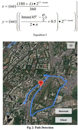
and the traffic map with transparent background can be stacked on the top of these three major types of map to provide additional traffic information of the roads. All map images are composed of 256x256 pixels PNG format image tiles. The parameter “v” means the map data version. The parameter “zoom” means the zoom actor, and it takes the value scope as 0~17, The parameter “x” means the map tile serial number along the longitude direction, and parameter “y” means the map tile serial number along the latitude direction. Both “x” and “y” take the value scope from zero to 17 . The parameter “t” is a string formed by array of 4 characters- “q”, “r”, “s” and “t”, and it means the serial number of the satellite map tile. The whole world becomes a 256x256 pixels map tile when the zoom value equals to 17, its center longitude and latitude are both zero, the t value is "t", the x and y values are both zero. The rest may be deduced by analogy that if zoom decreased by one, each map tile splits into four map tiles, the tag of these four new map tiles are arranged from Top Left to Right bottom in clockwise direction align to the order of “qrst”, the serial number of the new map tile is the original map tile’s serial number plus the given tag. In order to obtain the URL of the map tile at desired longitude and latitude, we need to transform the longitude and latitude into x and y coordinator, Google map's Mercator projection formulas are as below:
Equaltion I
Fig 2: Path Detection
Among the formula, λ is the east longitude varies from-180 to +180 degrees, ϕ is the north latitude. Among them, e is the natural logarithmic base. Specially, when y equals to zero, the latitude of the top left corner will be 90 degree, and when y equals to 17 , the latitude of the right bottom corner will be -90 degree.
Distance calculation:
Equation II
Google direction:
Among them, “saddr” means the source address, “daddr” means the target address, and they all can be street address, city name or location point defined by latitude and longitude. If the city name is used, then the Google defined central point of that city will be adopted. If the location point is used, Google will find the closest point on the nearby roads as source or target point of the direction. “ie” means the encoding method of the returned page. From the result page, the direction path information can be fetched, including the path points, and the text description of the path. Among the result page, the text description can be read directly, but the direction path points are in the so-called Encoded Polyline string. The encoding process converts a binary value into a series of character codes for ASCII characters using the familiar base64 encoding scheme: to ensure proper display of these characters, encoded values are summed with 63 (the ASCII character '?') before converting them into ASCII. The algorithm also checks for additional character codes for a given point by checking the least significant bit of each byte group. if this bit is set to 1, the point is not yet fully formed and additional data must follow. Additionally, to conserve space, points only include the offset from the previous point (except of course for the first point). All points are encoded in Base64 as signed integers, as latitudes and longitudes are signed values. The detailed steps for encoding a signed value like longitude and latitude can be found in Google Map API document.
Fig 3: Google Map Interrface
Assume that point P( λ, ϕ ) is the map center, and ''' P( λ`, ϕ`) is a yellow page item or direction path point, then the pixel distance between these 2 points can be calculated as below:
Equation III
III. DESIGN&ANALYSIS
ISSN(E): 2277-128X, ISSN(P): 2277-6451, pp. 42-52
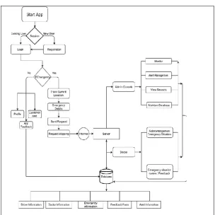
Fig 4: Block Diagram of the implemented system
Fig 6: Data Flow Diagram of the implemented system
Prov ide assistance to paramedic Prov ide f eedback to app Rev iew emergency data
Doctor
Enter pickup location
Store estimated time of arriv al
Store actual time of arriv al Patient Data
Paramedic record Enter v ictim data
Enter geographical data
Enter ty pe of casualty
Acknowledge app once trip ends
Respond to alert (if generated) Traf f ic Assistance
Driv er
Login/Registration
Enter destination hospital
Prov ide route to paramedic
Monitor paramedic route
Generate alert if certain condition occurs
Store data
Application
<<includes>.
<<includes>>
<<includes>> <<includes>> <<includes>>
<<includes>> <<includes>>
Smart Ambulance
ISSN(E): 2277-128X, ISSN(P): 2277-6451, pp. 42-52
Fig 8: Activity Diagram of the implemented system
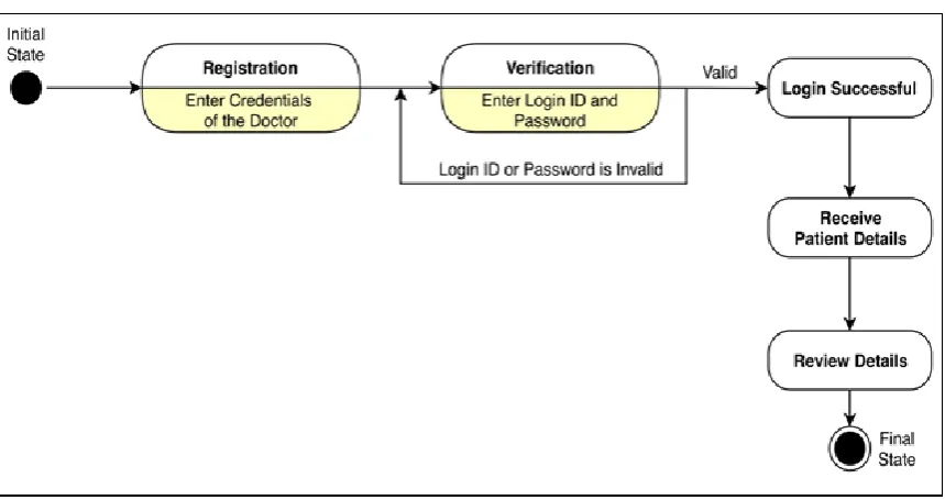
Fig 10 :State Diagram of the implemented system (Driver)
ISSN(E): 2277-128X, ISSN(P): 2277-6451, pp. 42-52
Fig 12: State Diagram of the implemented system (Traffic Assistance)
The methodology proposed in this project is based on ambulance services. The work is divided into various modules as follows:
Registration (Driver, Doctor, Traffic Administrator) Login
View Profile
Requesting for emergency details Provide route tracking
Traffic assistance monitoring Alert generation
Emergency situations handled
B. Module-wise working breakdown
Registration:
Here the user is registered into the system on website. Registration will be done for driver, doctor, traffic administrator which are associated and authenticated according to their connecting entities i.e. Ambulance driver should be addressed and associated to the hospital, doctor should be associated to the hospital. Registration is done through the website connected to the application.
Login:
Here the users can login to the application and also to the website for using the proposed system functions.
View Profile:
All the users can view their profile and can edit and update their profiles as per their needs.
Requesting for emergency details:
Here the ambulance drivers request for emergency as the emergency condition urges and will fill the limited verifying patient details in the application with the hospital destination and will request for emergency which will provide maps with all the possible routes.
Provide route tracking:
After requesting for emergency, the app will provide a full mapping and routing to help the patient reaching to the hospital as fast as possible. All the possible routes with the proper route time will be displayed.
Traffic assistance monitoring:
When the emergency is created, it gets displayed to the traffic assistance website. Traffic control room contains traffic administrator which will monitor the emergencies and will help the driver to reach the hospital.
Alert generation:
An alert will be generated if the ambulance gets stuck in traffic and is not moving in the fixed time limit then an alert will be generated. Then the traffic control room will coordinate to the nearest police officer and then the officer will help to remove the ambulance from the traffic and help the patient to reach the hospital as fast as possible.
Emergency situations handled:
All the emergency situations occurred and the details of all the successful transfer of the patient to the hospital are then displayed. Data will be reviewed at the end of the day by the doctor which was held for the patient and a review form will be get filled by the doctor for authenticating the emergency details as per specified.
V. FUTURE ENHANCEMENT
Project can be updated in near future as and when requirements for the same arise, as it is very flexible in terms of expansion. With the proposed software of database MySQL (MariaDB) ready and fully functional ambulance services is now able to be managed and hence run the entire work in a much managed way, accurate and with a centralized database. The following enhancements can be done in the currently implemented system:
1) Mumbai Traffic Police can use this app for saving lives of the people.
2) Private hospitals and agencies can implement the app according to their needs. 3) A database is maintained which will be helpful for emergency situations in future.
VI. CONCLUSION
ISSN(E): 2277-128X, ISSN(P): 2277-6451, pp. 42-52
emergency situation occurred during the whole crisis. Ambulances getting stuck in traffic which leads many people to death. According to WHO in 2016, 30% of people died in ambulances due to traffic. In Smart Ambulance based application, all the Ambulance services linked with the application hence can be monitored and reviewed by a central management node which can even keep a track of data flow and provide useful data for analysis. If tied with Mumbai Traffic Police can provide improved emergency response and avoid delays caused in emergency situations. The hospital management can keep track of all the emergency vehicles and monitor their activities thereby. Drivers can get easy and fastest route for travelling to the hospital. Alert generation is provided for faster reach due to traffic. Data review and data analysis will be done to provide fastest route and easy management and helping people more by saving the lives.
REFERENCES
[1] Dawn Griffiths, David Griffiths- Authors of “Head First Android Development”, you’ll learn hands-on
how to structure your app, design interfaces, create a database, June 2015.
[2] Ben Forta- Author of “Sams Teach Yourself SQL in 10 Minutes”, it teaches us topics like the use of sql
joins, sub-queries, stored procedures, cursors, triggers, and table constraints, May 1994.
[3] Alan Forbes- Author of “The Joy of PHP Programming: A Beginner’s Guide”, it teaches how to create and run
simple PHP scripts to modify web pages, August 1982.
[4] Williams R.T. Lambert and Mercator map projections in geology and geophysics. Computers and Geosciences,
1995.
[5] John P. Snyder. Map projections used by the U.S geological survey. Washington: U.S. Government Printing Office, 1982.
[6] Yoshiaki Ohsawa, Hirofumi Kagaya, Takeshi Koshizuka. Map projection errors in the weber problem. J
Geograph Syst (2002).
[7] Volgyesi, Lajos. Conversion between Austrian and Hungarian map projection systems.
[8] https://stackoverflow.com/
[9] https://developer.android.com/
[10] https://www.youtube.com/channel/UCFNPuSU9 9YOWy94LhRCZcfw
[11] https://www.youtube.com/channel/UCoNZZLhPuuRteu02rh7bzsw