72:3 (2015) 75–82 | www.jurnalteknologi.utm.my | eISSN 2180–3722 |
Full paper
Jurnal
Teknologi
Physical Characteristics of Boulders Formed in the Tropically Weathered
Granite
Mohd Firdaus Md Dan,a,*Edy Tonnizam Muhamad,b Ibrahim Komoo,c , Mohd Nur Asmawisham Alelb
aFaculty of Civil and Environmental Engineering, Universiti Tun Hussein Onn Malaysia, 86400 Batu Pahat, Johor, Malaysia bFaculty of Civil Engineering, Universiti Teknologi Malaysia, 81310 UTM Johor Bahru, Johor Malaysia
cUniversiti Malaysia Terengganu,21030 Kuala Terengganu, Terengganu, Malaysia
*Corresponding author: firdausd@uthm.edu.my
Article history
Received: 17 August 2014 Received in revised form: 17 November 2014 Accepted: 24 December 2014
Graphical abstract
Abstract
Deep weathering profile is a common phenomenon for humid tropic especially in Malaysia. The reactions of deep weathering under soil surface are decomposition of the massive rock and formation of thick stratum of soil and boulders. However, the occurrence of embedded boulders or loose blocks in the highly to completely weathered in the hilly area is not fully understood and investigated. This paper investigates the occurrence and physical characteristics of boulders in the granitic area. The parameters investigated are boulder’s discoloration, size, shape, rindlet properties and their distribution. Colour and shape were determined based on rock colour chart by Krumbein and Croft’s chart respectively. Size, rindlet and its distribution were determined based on field observation. Field results revealed that boulders in the hilly area can be found as shallow as 2 m from ground surface. In addition, it is found that boulder that embedded in deeper zone became larger in size and surrounded by thicker rindlet of up to 50 cm thick. Boulders embedded in soil stratum at weathering zone 4 and 5 are mostly independent and scattered around the weathering profile. The boulders can also be presented in various shapes; the smaller boulder is located at the upper zone more to flat to very spherical shape and rounded to well rounded edges, while the larger boulder that is located at lower zone more to sub-spherical shape and well rounded edges.
Keywords: Boulder; physical characteristics; weathered granite; tropical region Abstrak
Profil luluhawa dalaman adalah suatu fenomena biasa bagi kawasan tropika lembab terutamanya di Malaysia. Tindak balas luluhawa dalaman di bawah permukaan tanah menghuraikan batuan besar dan membentuk strata tanah tebal dan batu bundar. Walaubagaimanapun, kejadian batu bundar tertanam atau blok longgar di dalam luluhawa tinggi hingga sepenuhnya di kawasan berbukit masih tidak difahami dan disiasat sepenuhnya. Kajian ini menyiasat tentang kejadian dan ciri-ciri fizikal batu bundar dalam kawasan granit. Parameter dikaji termasuk perubahan warna batu bundar, saiz, bentuk, ciri-ciri rindlets dan taburannya.Warna dan bentuk ditentukan berdasarkan carta warna batu dan Carta Krumbein dan Croft. Saiz, rindlets dan taburannya ditentukan berdasarkan pemerhatian lapangan. Keputusan lapangan mendedahkan bahawa batu bundar di kawasan berbukit boleh ditemui sedalam 2 m dari permukaan tanah. Didapati, saiz batu bundar semakin besar di kawasan zon yang lebih dalam dan dikelilingi oleh rindlet yang tebal sehingga 50 cm. Batu bundar yang tertanam di zon luluhawa 4 dan 5 kebanyakannya bebas dan berselerak di sekitar profile luluhawa. Batu bundar boleh wujud dalam pelbagai bentuk; batu yang lebih kecil terletak di zon atas lebih berbentuk rata kepada sangat bulat dan dikelilingi oleh sudut yang sangat bulat, manakala batu bundar yang lebih besar terletak di zon lebih dalam dengan bentuk lebih kepada sub-bulat dan bersudut sangat sub-bulat.
Kata kunci: Batu bundar; ciri-ciri fizikal; granit terluluhawa; kawasan tropika
© 2015 Penerbit UTM Press. All rights reserved.
1.0 INTRODUCTION
In Malaysia, most rock formations experience weathering process whereby a natural process that changes the fresh rock to be
completely weathered and residual soils1. The weathering can
occur as deep as thickness of up to 100 m while weathering in
granitic rocks commonly weathered up to 10 to 30 m deep 2.
Furthermore, the highly intensity of rainfall in tropical region throughout the year such as in Malaysia will rapidly increase the reaction of weathering on the certain rock mass whether on the
ground surface or embedded in the soil stratum2–5. The infiltration
of rainfall deep into bedrock under soil stratum gradually will transform intact bedrock to be saprolite by the reaction of spherical
weathering on the fractured rock block6,7. The deep weathering on
Granite Boulder
Corestone (Grade II)
Rindlets (Grade III/IV)
< 50 cm thick
Saprolite (Grade IV/V) Alteration in
and then progressively altering the rock turn to become oblong in
shape or rounded known as boulder 8–10.
Although the investigations on soil weathering on weathered
granite in Malaysia had been done by previous researchers1,4,11–14
but the occurrence and characteristics of boulders in some weathered granite slope in humid tropics especially in Malaysia are not fully understood and rarely investigated. Therefore, this paper is attempted to focus on the occurrences and physical characteristics of boulders in tropically weathered granite.
1.1 Characteristics of Boulder in Humid Tropics
In humid tropics like Malaysia, boulder is normally found embedded 10 m to 20 m from ground surface and commonly it is found in weathering zone 3 to 5 (moderately to completely
weathered) 4,12,14. Boulder is a spheroidal weathering product on a
fractured rock that normally cores rounded form with a wide range of size and surrounded by spherical shells, separated by regions of
highly weathered rock 3,15. The occurrence of boulder in weathered
granite is due to the presence of discontinuity planes in the original
bedrock 14.The formation of boulder is also normally related to the
exfoliation process which is the rock breaks away from the parent
rock or rock mass 16. The fracturing activities on the fractured
bedrock gradually subdivide the bedrock into smaller block and then the spheroidal weathering will take part, transforms the
smaller block to become rounded 17.
There are several definitions on boulder. Boulder is defined as a corestone that formed via the reaction of spheroidal weathering on fractured bedrock, surrounded by concentric rindlet layers and saprolite3,8,18. Boulder is also defined as spherical or cylindrical shape, possessed different size of diameter and located anywhere
in the geologic medium that encountered 19. Boulder is also can be
defined as a large rounded mass of rock with size greater than 0.3m which is lying on the surface of the ground or embedded in the
sediment and soil 10.
Boulder presents in various shapes from spherical to ellipsoidal and some of them can be found virtually perfect spheres
while others are almost cubic with rounded edges20. The various
shapes of boulder are due to the spheroidal weathering reaction on fractured rock which is transforming a polyhedron shape of the
rock to become sphere 21. Spheroidal process is gradually
minimizing the volume of the boulder and when it becomes rounded, the rate of weathering will be slower than other shape that
have much edges and corners 17,21.
Boulders are commonly found surrounded by three to six
concentric sheets or layers6–8,18,21,22. The first layer of boulder that
is located near the boulder itself is corestone-rindlet interface, then followed by rindlet zone, rindlet-saprolite zone, protosaprolite layer and saprolite zone and the upper layer near the ground surface
is soil3,23. There are various names for the concentric layers of the
boulder, some of researchers called them as layers24 or onion-skin
layers6, shells17,21,22 or spherical shell 9, or rindlets 3,8,18,25,26. Therefore in this study, the term rindlets are used to describe the individual layers consistent with terminology that is used by most of the researchers a few years before.
2.0 FIELD WORKS PROGRAMS AND JUSTIFICATION
This section describes the field observation and field work programs that have been carried out to obtain physical parameters needed to quantify the weathering grade classification, boulder
and rindlets properties.
2.1 Field Observation in Tropically Weathered Granite
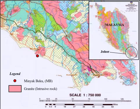
Field observation and investigation were carried out on 15-17 July 2013 at Minyak Beku (MB), Batu Pahat Johor, Malaysia (N1°49’23.0124’’ E102°55’34.9716’’) (Figure 1). According to the geological map of peninsular Malaysia, Batu Pahat Johor is identified as one of the intrusive granite rocks located at the southeast Malaysia27.
[image:2.612.318.559.180.369.2]
Figure 1 Location of the granite rock in Minyak Beku, Batu Pahat.
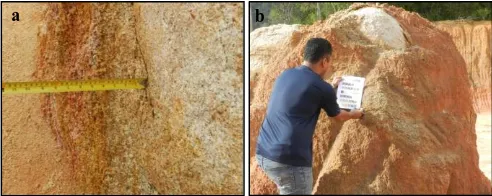
The selection of location in this study is based on availability of the stage of weathering grade, distribution and occurrence of embedded boulders, and natural occurring boundaries within the area. In order to identify the occurrence of boulder in weathered granite, scanline survey has been carried out on the weathered granite slopes. Two panels of rock face at the same location were chosen for investigation. The first panel is marked as A while another panel as B (Figure 2). For panel A, the length of the face studied is 56 m with the high ranged from 20 to 25 m from excavated ground surface. For panel B, the length and the high ranged of face studied are 40 m and 18 to 20 m respectively.
2.2 Weathering Grade Classification and Boulder Distribution
Determination of weathering grade classification is in accordance to ISRM28 with additional information from published journals by previous researchers1,29. The occurrence of boulders in weathering profile is observed for both of panel A and B and recorded in term of its distribution and depth from ground surface. Weathering profile that was published by Komoo12 and Raj30 are used as guidelines for identifying the boulder distribution in weathered granite.
Johor MALAYSIA
Minyak Beku, (MB)
Granite (Intrusive rock)
Figure 2 Photos of studied site; A) Panel A, B) Panel B
2.3 Classification of Boulder Shape and Size
A total of 40 boulders embedded have been observed and analyzed. The boulders were randomly chosen from panel A and B which are 6 nos. of boulders from panel A and 34 nos. of boulders from panel B. In order to determine the shape parameters of boulder, two properties are considered namely sphericity and roundness as suggested by Wadell31, Krumbein32 and Crofts33. Sphericity is how close a rock to form spherical shape and roundness is the smoothness of the rock edges 34. Although the suggested method was done on smaller size of particle, but in term of shape, this approach is reasonable and can be applied for corestones or boulders as what was done by Yang and Wu16. They carried out visual classification and utilized Krumbein chart to classify the corestones shape with the weathering grade of rock. Therefore in this study, visual classification is conducted and boulder shapes are classified in accordance to Krumbein’s and Crofts’s charts (Figure3).
Diameter of boulder is measured and the shape of boulder is
compared to the Krumbein’s and Croft’s charts (Figure 4). The visual observation considered the roundness and the sphericity of the boulder and the data was brought back to laboratory for shape classification.
2.4 Determination of Discolouration
[image:3.612.317.582.383.523.2]Most of previous researchers have classified the rock colour in accordance to standard rock chart that was published by Geological Society of America30,35. For instance, Commission of Engineering Geological Mapping36 used rock chart to classify the colour of rock and soil for engineering geological mapping. Therefore in this study, discolouration on boulder, rindlet and saprolite has been determined based on rock chart of Geological Society of America that was republished by Munsell37.
Figure 3 Shape classification with roundness numbers and sphericity; a) Krumbein’s chart, b) Crofts’s chart.
Figure 4 Shape of boulder basd on Krumbein’s and Crofts’s chart; a) Spherical shape with rounded edges; b) Sub-spherical shape with rounded shape edges.
Visual comparison of colour has been made between
boulder found in panel A and B with the rock chart and the code
a
b
[image:3.612.322.569.560.665.2]colour among boulder, rindlet and saprolite in weathering zone are identified and analyzed.
Figure 5 Identification of rock colour; a) Rock colour chart, b) Determination of boulder’s colour
2.5 Determination of Rindlets Properties
[image:4.612.53.297.99.198.2]The rindlets properties that are analyzed are thickness and layers, discolouration, texture, surface roughness and friability (Figure 6). The rindlets thickness was measured using measuring tape and the average thickness of rindlet is calculated. Identification on rindlets colour is carried out based on visual observation and it is compared to rock colour chart. Determination of texture, surface roughness and friability are based on ISRM28. The same methods were done on the corestone surface.
Figure 6 Field works on the boulder’s rindlets; a) Measurement on the rindlets thickness, b) Identification of rindlets colour.
2.6 Boulder Data and Analysis
From the field study, the boulders are classified into four groups based on their diameter found embedded in weathered granite. The groups are S, M, L and XL where group S is for boulder with size in range of 0.3 to 1.0 m; group M is for size in range of 1.0 to 2.0 m; group L is for size in range of 2.0 to 5.0 m and group XL is for size larger than 5.0 m.
Panel A
Based on the field study, no boulders were found in weathering zone 6 (residual soil). Boulder was also not found in weathering zone 5 (completely weathered). However, 6 boulders with size M, L and XL were found embedded in weathering zone IV (highly weathered). 2 boulders with size 1.0 m to 2.0 m (group M) were found 20 m from ground surface. Meanwhile, 3 boulders with size 2.0 m to 5.0 m (group L) were found embedded 18 m from ground surface and 1 boulder with XL size (diameter more than 5 m) was found embedded 15 m from ground surface.
Panel B
According to field observation, no boulder was found in weathering zone 6 but boulders were found in weathering zone 4
boulders with size S (0.3 to 1.0 m) were embedded in zone 5 with thickness of 2 m to 10 m from ground surface. Meanwhile, 3 boulders with diameter 1.0 m to 2.0 m (group M) encountered in weathering zone 5 which is situated 2 m to 10 m from ground surface but 1 of them embedded in zone 4 which is located 10 m from ground surface. However, 1 boulder with diameter of 2.0 m to 5.0 m (group L) was found embedded in zone 5 at depth 1 m from ground surface.
3.0 RESULTS AND DISCUSSION
This study revealed some findings on the occurrences and distribution of boulders. According to field observation, boulders that embedded in weathered granite of humid topics in hilly area can be found as deep as 1 m from ground surface. Boulder is found in weathering zone 4 (highly weathered) to zone 5 (completely weathered) but not available in zone 6 (residual soil). The typical characteristics of the boulder, rindlets and saprolite can be summarized as in Table 1 and Table 2.
Most corestones that formed boulder are identified as grade
II or slightly weathered rocks which are hard to break, require more than one blows of geological hammer to fracture it and possess light grey to greyish orange pink colored. Boulder presents in variety of shapes in weathering profile; upper zone (zone 5) is more to flat to very spherical shape with well-rounded to rounded edges, while the deeper zone (zone 4) is more to sub-spherical to sub-spherical shape with edges rounded to well rounded. This is constant with Twidale20, who stated that boulder presents in various shapes under the soil stratum. The field study has also shown that boulders are surrounded by rindlets and saprolite as reported by previous study3. Boulder with size 0.3 m to 1 m is surrounded by rindlet 1-7 cm thick; 1 m to 2 m diameter is surrounded by rindlets 6-14 cm thick; 2 m to 5 m diameter is surrounded by 8 -17 cm and diameter more than 5 m is surrounded by rindlet 10 to 50 cm thick.
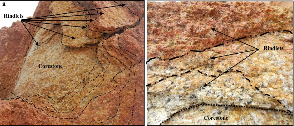
Rindlet is found to be surrounding the boulders with more
than three to six layers (Figure 7). This finding is constant with the previous researchers’ reports6–8,18,21,22. Rindlets that surrounded the corestone are identified as weathering grade III or IV while saprolite is classified as weathering grade IV or V based on ISRM, (1981). Saprolite is the outer layer of boulder and located at near the ground surface. Saprolite is found thicker than rindlet where its thickness ranged from 2 m to 20 m thick, with different weathering grade either grade IV (highly weathered) or V (completely weathered). The saprolite colour normally found darker than rindlet colour, light to moderate red coloured. The differences of weathering grade of saprolite depend on where the boulder is found in weathering profile.
4.0 CONCLUSION
Studies on boulders of weathered granite in humid tropics in term of physical characteristics revealed summarization on this matter. Boulder in humid tropic of weathered granite is formed in various shapes depending on its size and location in weathering zone; upper zone (zone 5) is more to flat to very spherical shape with well rounded edges, while the deeper zone (zone 4) is more to sub-spherical to spherical shape with rounded edges. Boulder consists of three main elements namely corestone, rindlets and saprolite. Each element has different properties in term of weathering grade, colour, texture and friability.
a b
[image:4.612.49.295.341.439.2]Figure 1: Rindlets with different layers; (A) 6 layers of rindlets, (B) 3 layers of rindlets
[image:5.612.61.547.326.644.2]Figure 7 Rindlets with different layers; a) 6 layers of rindlets, b) 3 layers of rindlets.
Table 1 Physical characteristic of boulders
Zone Photo Weathering
Grade2
Colour1 Friability2 Remarks
Corestone
II Light grey to greyish orange
pink
Cannot be scraped or peeled by hand; require more than one blow of geological hammer to fracture it.
The material fabric is still intact; its surface is rough, covered by 1 to 2 mm thin layer of rock sheets.
Rindlets
III/IV Greyish orange pink to reddish
orange
Can be peeled and fractured by hand but with difficulty.
Material fabric is untextured, rougher than corestone, present in 3 to 6 layers, each layer 5 to 10 cm thick.
Saprolite
IV/V Moderate Red/ Light Red
Can be peeled and crumbled when compressed by hand.
Some or half rock material is decomposed and rough.
1 According to rock chart of American Geological Society, republished by Munsell, (2009). 2 Based on evaluation by ISRM, (1981).
b
Corestone
Rindlets
Corestone Rindlets
Table 2 Characteristics of boulders in weathering profile of weathered granite
Group Boulder Dia. Size
(m)
Boulder’s Description
S 0.3-1.0
Corestones:
W/G: grade II (slightly weathered).
Shape: flat to very spherical shape and rounded to well rounded edges.
Friability: need more than one blow of geology hammer to fracture it.
Colour: light grey to medium light grey,
Location Found: distributed in grade V (completely weathered granite), located as deep as 2 to 10 m from ground surface.
Rindlets:
W/G: grade III or IV (moderately to highly weathered).
Thickness: covered by 1 to 2 mm thin layer of rock sheets and wrapped by thin layer of rindlets of 1-7 cm thick with.
No. of layer(s): 3 to 4 layers
Friability: friable and crumbled when broken by hand.
Colour: greyish orange pink to moderate red coloured
Saprolite:
W/G: grade IV or V (highly to completely weathered).
Thickness: 1.99 to 9.93 m.
Friability: Can be peeled and crumbled when compressed by hand,
Colour: Moderate Red
M 1.0-2.0
Corestones:
W/G: grade II (slightly weathered).
Shape: sub-flat to spherical shape and rounded to well rounded edges.
Friability: hard to be broken by geology hammer.
Colour: medium light grey coloured.
Location Found: in grade IV and V (highly & completely weathered), encountered in depth 10-20 m from ground surface. But, it can be found as shallow as 2 m from ground surface.
Rindlets:
W/G: grade III or IV (moderately to highly weathered).
Thickness: covered by 1 to 2 mm thin layer of rock sheets and surrounded by rindlet of 6-14 cm thick.
No. of layer(s): 3 to 4 layers.
Friability: can be peeled by hand or chisel.
Colour: greyish orange pink to moderate reddish brown coloured.
Saprolite:
W/G: grade IV or V (highly to completely weathered).
Thickness: 1.94 to 19.86 m.
Friability: Can be peeled and crumbled when compressed by hand.
Colour: Light Red to Moderate Red.
L 2.0-5.0
Corestone:
W/G: grade II (slightly weathered).
Shape: sub-spherical with sub-rounded edges.
Friability: require more than one blows of geological hammer to fracture it.
Colour: medium grey coloured.
Location Found: more than 10 m from ground surface, at grade IV (highly weathered zone) but also found 1 m from ground surface.
Rindlets:
W/G: grade III to IV (moderately to highly weathered).
Thickness: 1 to 2 mm thin layer of rock sheets and 8 -17 cm thick.
No. of layer(s): 3 to 6 layers.
Friability: quite hard to peel it from corestone by hand.
Colour: brown stain coloured.
Saprolite:
W/G: grade IV or V (highly to completely weathered).
Thickness: 0.92 to 17.83 m.
Friability: Can be peeled and crumbled when compressed by hand.
Colour: Moderate Red or Light Red.
XL > 5.0
Corestone:
W/G: grade II (slightly weathered).
Shape: sub-spherical shape and well rounded edges.
Friability: requires many blows of geological hammer to fracture it.
Colour: greyish orange pink coloured.
Rindlets:
W/G: grade III (moderately weathered)
Thickness: covered by 1 to 2 mm thin layer of rock sheets and surrounded by thick rindlet of approximately 10 to 50 cm.
No. of layer(s): 4 to 6 layers.
Friability: can be peeled and fractured by hand with difficulty.
Colour: moderate reddish orange coloured.
Saprolite:
W/G: grade IV (highly weathered).
Thickness: 19.8 m
Friability: Can be peeled and crushed by hand.
Colour: Moderate Red or Light Red.
W/G: weathering grade based on ISRM (1981).
The outer layer of boulder has higher weathering grade compared to the inner boulder that has lower weathering grade as follows; boulder → rindlets → saprolite with weathering grade change from grade II → grade III/IV → grade IV/V. The colour of corestone, rindlet and saprolite is different in term its brightness, which is the changes from corestone to saprolite with the sequence of light grey → light orange → light red. The rindlet has three to six layers and its texture is rougher than corestone and harder than saprolite texture surface. The thickness of rindlet is found relative with the boulder size where the larger boulder possesses the thicker rindlets thickness.
Acknowledgement
We are grateful to Mr. Bujang and his company for facilitating works in the field. The authors also want to thank and express appreciation to Geological laboratory of Universiti Tun Hussein Onn Malaysia and Universiti Teknologi Malaysia for the contribution in the analysis.
References
[1] Komoo I. 1985. Engineering properties of weathered rock profiles in
Peninsular Malaysia. In: Proceedings of the eighth Southeast Asian
conference geotechnical conference, Kuala Lumpur.1(3–81): 3–86.
[2] Chigira M, Mohamad Z, Sian L.C, Komoo I. Landslides in weathered
granitic rocks in Japan and Malaysia. Bull Geol Soc Malaysia,.
2011;Vol.57:pp.1–6. doi:10.7186/bgsm2011001.
[3] Buss H.L, Sak P.B, Webb S.M, Brantley S.L. 2008. Weathering of the
Rio Blanco quartz diorite, Luquillo Mountains, Puerto Rico: Coupling
oxidation, dissolution, and fracturing. Geochim Cosmochim
Acta.72(18):4488–4507. doi:10.1016/j.gca.2008.06.020.
[4] Komoo I. 1995. Geologi kejuruteraan perspektif rantau tropika lembab.
Syarahan Perdana,Universiti Kebangs Malaysia, Bangi, Selangor Malaysia. 1–62.
[5] Rahardjo H, Rezaur R.B, Leong E.C. 2009. Mechanism of
rainfall-induced slope failures in tropical regions. 1st Ital Work Landslides
Napoli, Italy. 8–10.
[6] Buss H.L, White A.F, Brantley S.L. 2004. Mineral dissolution at the
granite–saprolite interface. 11th Int Symp Water–Rock Interact. 11:819–
823.
[7] Ollier C. 1971. Causes of spheroidal weathering. Earth-Science Rev.
7(3): 127–141.
[8] Fletcher R, Buss H, Brantley S.A. 2006. Spheroidal weathering model
coupling porewater chemistry to soil thicknesses during steady-state
denudation. Earth Planet Sci Lett. 244(1–2): 444–457.
doi:10.1016/j.epsl.2006.01.055.
[9] Røyne A, Jamtveit B, Mathiesen J, Malthe-Sørenssen A. 2008. Controls
on rock weathering rates by reaction-induced hierarchical fracturing.
Earth Planet Sci Lett. 275(3–4): 364–369.
doi:10.1016/j.epsl.2008.08.035.
[10] Felletti F, Beretta G Pietro. 2009. Expectation of boulder frequency
when tunneling in glacial till: A statistical approach based on transition
probability. Eng Geol. 108(1–2):43–53.
doi:10.1016/j.enggeo.2009.06.006.
[11] Komoo I. 1982. Hakisan cerun potongan pada batuan metasedimen di
sepanjang lebuhraya Kuala Lumpur-Sremban. Ilmu Alam.11: 25–39.
[12] Komoo I. 1989. Engineering properties of the igneous rocks in
Peninsular Malaysia. Proc 6th Reg Conf Geol Miner Hydrocarb Resour
Southeast Asia, Jakarta, Indones. 445–458.
[13] Raj J.K. 2010. Soil-moisture Retention Characteristics of Earth
Materials in the Weathering Profile over a Porphyritic Biotite Granite. Am J Geosci. 1(1):12–20. doi:10.3844/ajgsp.2010.12.20.
[14] Raj J.K. 1985. Characterisation of the weathering profile developed over
a porphyritic biotite granite in peninsular Malaysia. Bull Int Assoc Eng
Geol - Bull l’Association Int Géologie l'Ingénieur. 32(1): 121–129.
[15] Ollier C.D. 1971. Causes of spheroidal weathering. Earth-Science Rev.
7(3):127–141.
[16] Yang Z.Y, Wu T.J. 2006. An index for describing the core-stone shape
in weathered columnar joints. Geotech Geol Eng. 24(5): 1349–1363.
doi:10.1007/s10706-005-2213-8.
[17] Jamtveit B, Hammer Ø. 2011. Chapter 7: Hierarchical fracturing during
weathering and serpentinisation. Geochemical Perspect. 418–432.
[18] Turner B.F, Stallard R.F, Brantley S.L. 2003. Investigation of in situ
weathering of quartz diorite bedrock in the Rio Icacos basin, Luquillo
Experimental Forest, Puerto Rico. Chem Geol. 202(3–4):313–341.
doi:10.1016/j.chemgeo.2003.05.001.
[19] Veneziano D, Van Dyck J. 2006. Statistics of Boulder Encounters during
Shaft Excavation. Rock Mech Rock Eng. 39(4): 339–358.
doi:10.1007/s00603-005-0068-1.
[20] Twidale C.R. 1982. Part II: Major forms and assemble, Chapter 4-
Boulders. In: Granite Landforms. Amsterdam: Elsevier. 89–123.
doi:10.1016/B978-0-444-42116-6.50009-2.
[21] Sarracino R, Prasad G. 1989. Investigation of Spheroidal Weathering
and Twinning. GeoJournal, Kluwer Acad Publ. 19(1): 77–83.
[22] Sørensen H, Bailey J.C, Kogarko L.N, Rose-Hansen J, Karup-Møller S.
2003. Spheroidal structures in arfvedsonite lujavrite, Ilı́maussaq alkaline
complex, South Greenland—an example of macro-scale liquid
immiscibility. Lithos. 70(1–2):1–20.
doi:10.1016/S0024-4937(03)00086-0.
[23] Zauyah S, Schaefer CEG., Simas F.N.B. 2010. Chapter 4 Saprolites.
Interpret Micromorphol Featur Soils Regoliths Elsevier, Amsterdam. 49–68. doi:10.1016/B978-0-444-53156-8.00004-0.
[24] Kirschbaum A, Martínez E, Pettinari G, Herrero S. 2005. Weathering
profiles in granites, Sierra Norte (Córdoba, Argentina). J South Am
Earth Sci. 19(4): 479–493. doi:10.1016/j.jsames.2005.06.001.
[25] Brantley S.L, Buss H, Lebedeva M, Fletcher R.C, Ma L. 2011.
Investigating the complex interface where bedrock transforms to
regolith. Appl Geochemistry. 26:S12–S15.
doi:10.1016/j.apgeochem.2011.03.017.
[26] Chabaux F, Blaes E, Stille P, et al. 2013. Regolith formation rate from
U-series nuclides: Implications from the study of a spheroidal
weathering profile in the Rio Icacos watershed (Puerto Rico). Geochim
Cosmochim Acta. 100: 73–95. doi:10.1016/j.gca.2012.09.037.
[27] General Director of Minerals and Geosciences Department of Malaysia.
1985. Geological Map of Peninsular Malaysia. Minist Nat Resour
Environ Malaysia. 8.
[28] ISRM. 2007. The complete ISRM suggested methods for rock
characterization, testing and monitoring: 1974-2006. Comm Test
Engineering Group Working Party Report. Q J Eng Geol Hydrogeol. 23(1): 4–101. doi:10.1144/GSL.QJEG.1990.023.001.01.
[30] Raj J.K. 1985. Characterisation of the weathering profile developed over
a porphyritic biotite granite in Peninsular Malaysia. Bull Int Assoc Eng
Geol l’Association Int Géologie l'Ingénieur. 32(1): 121–129.
[31] Wadell H. 1932. Volume, shape, and roundness of rock particles. J Geol.
40: 443–688.
[32] Krumbein W.C. 1941. Measurement and geological significance of
shape and roundness of sedimentary particles. J Sediment Res. 11(2):
64–72.
[33] Crofts R.S. 1974. A visual measure of shingle particle form for use in
the field. J Sediment Res. 44(3): 931–934.
Anal.
[35] Lan H.X, Hu R.L, Yue Z.Q, Lee C.F, Wang S.J. 2003. Engineering and
geological characteristics of granite weathering profiles in South China. J Asian Earth Sci. 21(4): 353–364.
[36] Commisson of Engineering Mapping Report. 1979. Classification of
rocks and soils for engineering geological mapping Part I: rock and soil
materials. Bull Int Assoc Eng Geol - Bull l’Association Int Géologie
l'Ingénieur. 19(1): 364–371.
[37] Munsell Color. 2009. Geological ROCK-COLOR CHART. Geol Soc
Am Munsell Color chips. 6–11.
[38] ISRM. 1981. Rock characterizition, testing and monitoring. InBrown