www.hydrol-earth-syst-sci.net/19/2261/2015/ doi:10.5194/hess-19-2261-2015
© Author(s) 2015. CC Attribution 3.0 License.
Evolution of the human–water relationships in
the Heihe River basin in the past 2000 years
Z. Lu1,2, Y. Wei3, H. Xiao1, S. Zou1, J. Xie4, J. Ren1, and A. Western3
1Key Laboratory of Ecohydrology of Inland River Basin, Cold and Arid Regions Environmental and Engineering Research Institute, Chinese Academy of Science, Lanzhou, China
2University of the Chinese Academy of Science, Beijing, China
3Australia China Joint Research Centre on River Basin management, Department of Infrastructure Engineering, the University of Melbourne, Parkville, Australia
4Key Laboratory of Desert and Desertification, Cold and Arid Regions Environmental and Engineering Research Institute, Chinese Academy of Science, Lanzhou, China
Correspondence to: Y. Wei ([email protected])
Received: 30 December 2014 – Published in Hydrol. Earth Syst. Sci. Discuss.: 23 January 2015 Revised: 20 April 2015 – Accepted: 25 April 2015 – Published: 12 May 2015
Abstract. This paper quantitatively analyzed the evolution of human–water relationships in the Heihe River basin of northern China over the past 2000 years by reconstructing the catchment water balance by partitioning precipitation into evapotranspiration and runoff. The results provided the ba-sis for investigating the impacts of societies on hydrolog-ical systems. Based on transition theory and the rates of changes of the population, human water consumption and the area of natural oases, the evolution of human–water re-lationships can be divided into four stages: predevelopment (206 BC–AD 1368), take-off (AD 1368–1949), acceleration (AD 1949–2000), and the start of a rebalancing between hu-man and ecological needs (post AD 2000). Our analysis of the evolutionary process revealed that there were large dif-ferences in the rate and scale of changes and the period over which they occurred. The transition of the human–water re-lationship had no fixed pattern. This understanding of the dynamics of the human–water relationship will assist policy makers in identifying management practices that require im-provement by understanding how today’s problems were cre-ated in the past, which may lead to more sustainable catch-ment managecatch-ment in the future.
1 Introduction
The development of land and water resources within catch-ments over thousands of years has led to spectacular growth in agricultural production along with increased human con-sumption of water, significant modification of catchment vegetation, and serious degradation of ecosystems, world-wide (Carpenter et al., 2011; Falkenmark and Lannerstad, 2005; Röckstrom et al., 2009; Vörösmarty et al., 2010). Fu-ture human wellbeing may be seriously compromised if we pass a critical threshold that tips catchment ecosystems into irreversible degradation.
Historical analysis is a key method of socio-hydrology in which hydrological analysis over a long time frame is a key component. Accurate historical data for hydrology, climate, land use, ecology and geomorphology are often unavailable, but hydrological reconstruction that aims to generate long-term data sets could provide a basis for the identification, de-scription and parameterization of feedback mechanisms be-tween human activities and water (Thompson et al., 2013). Empirical reconstructions of changes in single hydrological elements at specific locations have been reported, including precipitation, streamflow, water salt content and lake levels (Turner et al., 2008; Lowry and Morrill, 2011). Whilst these studies are empirically informative, few of them have been conducted on water balance in basins that are facing signifi-cant threats such as water over-abstraction, sea level rise, or land use change, or in basins that experience major transi-tions (Vörösmarty et al., 2010).
In the social science literature, transition is a well-established concept. It is “a non-linear process of social change in which the structure of a societal system (energy sector, water management and agriculture) transforms” (Rot-mans, 2005). Although there are a considerable number of empirical studies focusing on the dynamics of transition, and in particular on the different stages and processes of transi-tion, they have been criticized for empiricism: good at de-scription but weak at explanation (Wimmer, 2006). There have already been several early attempts at exploring the co-evolution of human and water systems. For example, Xiao and Xiao (2004) divided the evolutionary processes of the human–land relationships affected by the water resources in the Ejin region, downstream of the Heihe River basin, into four periods. Geels (2005) studied the trajectories of the co-evolution of water technology and society in present-day Netherlands. Kallis (2010) studied the co-evolution of water resource development in ancient Athens. Pataki et al. (2011) provided an outline of the interplay of sociolog-ical and ecologsociolog-ical processes in urban water management. Unfortunately, most of them adopted “thick descriptive” ap-proaches that have poor explanatory and predictive ability. Recently, Elshafei et al. (2014) developed a prototype frame-work for models of social hydrology, including identification of some important feedback loops. The framework aims for more explanatory capability, although the fully parameter-ized dynamic coupled model has yet to be applied.
The Hexi Corridor, located in western Gansu Province, China, is an important part of the ancient Silk Road es-tablished in the Han Dynasty (206 BC–AD 220), and was a trade route between China and western countries that fa-cilitated cultural and economic exchange for approximately 1500 years. It is an arid area supported by oasis ecosys-tems where water dominates the dynamics of human soci-ety and natural systems, and therefore the interactions and feedbacks between humans and water are very prominent. The region has a rich written history of over 2000 years. Over-development of land and water resources over
thou-sands of years has significantly modified the catchment veg-etation conditions and desertification is a continuing process causing environmental degradation in the region (Xiao and Xiao, 2004, 2008).
The overarching goal of this paper is to reveal the evolu-tionary processes of human–water relationships in the Heihe River basin, an important part of the Hexi Corridor, for a pe-riod spanning approximately 2000 years over which hydro-logic, social and environmental systems interacted. The spe-cific objectives are to reconstruct the water balance on the basin scale over the past 2000 years and to determine the de-velopment stages of the evolution of the human–water rela-tionships. The analysis is used to gain important understand-ing of the human–water relationships and to provide guid-ance for the region’s sustainable development.
2 Methods 2.1 Study area
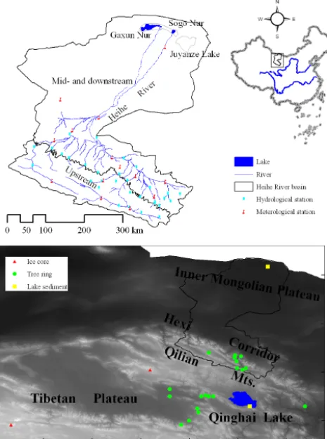
We selected the Heihe River basin (HRB) in northwestern inland China as our case study area. The HRB is located in the central Hexi Corridor, one of the most arid regions in the world. It covers approximately 130 000 km2 and is located at the climatic intersection between the Westerlies and the East Asian summer monsoon (Fig. 1). Many civilizations and cultures have flourished there, including the Siba culture, the Juyan Wooden Slips and the literature of Heishui (Cheng et al., 2011; Shi, 2007). The rise and fall of civilizations in the HRB is closely linked with water: when there is water, there are oases and flourishing societies; when there is no water, there are deserts and diminished human activities.
Figure 1. Location of the Heihe River basin and locations of ice
core, tree ring and lake sediment data.
a sharp decrease in water supply to the lower reaches during the last 50 years (Zhou and Yang, 2006). As a consequence, the ecosystems in the lower reaches have been degraded by land desertification, more frequent sandstorms, and the dry-ing of terminal lakes. Therefore, the HRB is a compelldry-ing case study area for an analysis of the co-evolution of human– water systems on a basin scale.
2.2 Study period
We selected the past 2000 years as our study period. This timescale represents a period in which dramatic changes in climate, land use, runoff, management policy, population, so-cietal development and catchment ecological conditions have occurred. These are major variables affecting the water cy-cles of river basins. It is also a time of significant civilization development in China, for which there is a wealth of docu-mentary evidence available (Holmes et al., 2009; Zheng and Wang, 2005).
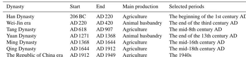
We reconstructed the co-evolutionary processes of societal development and hydrological systems based on seven peri-ods in the past 2000 years using the results of Shi (2010), Wang et al. (2013) and Xie et al. (2013) (Table 1). This re-construction was dependent on adequate land use
informa-tion, which resulted in some limitations in developing a con-tiguous hydrological data set over this long time frame. 2.3 Reconstructing the evolutionary processes of
catchment water balance
We used annual water balance partitioning to provide in-sights into the evolutionary processes of human–water rela-tionships on a basin scale. Such partitioning is widely used as a signature of hydrologic regimes when catchments ex-perience changes in precipitation regimes, temperature and land use change (Budyko, 1974; Sivapalan et al., 2003). For this study, the water balance equation can be written as
P+Rin=E+Rout, (1)
whereP andE are precipitation and evapotranspiration in the midstream and downstream areas of the HRB, respec-tively;Rin is the streamflow from the upstream part of the HRB into the midstream area; andRoutis the volume of wa-ter flowing into the wa-terminal lakes of the downstream areas. In arid regions, soil water content is very low, and the ground-water levels were stable over historical periods, so changes in soil water content and groundwater are negligible and not in-cluded in Eq. (1).
Due to a lack of measured data in historical periods, the reconstruction of P, Rin and E, and validation of the de-rived Rout from Eq. (1), are important steps for develop-ing catchment water balance over the long-term time frame necessary for understanding the co-evolutionary process of human–water relationships.
2.3.1 Reconstruction of precipitation (P) in the midstream and downstream areas
Table 1. Seven periods selected in the past 2000 years.
Dynasty Start End Main production Selected periods
Han Dynasty 206 BC AD 220 Agriculture The beginning of the 1st century AD Wei-Jin era AD 220 AD 420 Animal husbandry The end of the third century AD Tang Dynasty AD 618 AD 907 Agriculture The mid-8th century AD Yuan Dynasty AD 1271 AD 1368 Animal husbandry The end of the 13th century AD Ming Dynasty AD 1368 AD 1644 Agriculture The mid-16th century AD Qing Dynasty AD 1644 AD 1912 Agriculture The mid-18th century AD The Republic of China era AD 1912 AD 1949 Agriculture The 1940s
2.3.2 Reconstruction of streamflow into the midstream area:Rin
Dendrochronologically based hydrological reconstructions have been widely used to extend existing instrumental streamflow records, as streamflow variations correlate well with tree ring-width series (Woodhouse et al., 2006; Saito et al., 2008). There are many streamflow reconstruction stud-ies based on tree ring analyses for the Qilian Mountains. The longest streamflow record in this region is about 1400 years, developed by Yang et al. (2012), then 1300 years by Kang et al. (2002) and 1000 years by Qin et al. (2010). None of these streamflow reconstructions completely spans the 2000 years of interest.
In order to reconstruct the historical streamflow in the up-stream area of the HRB (Rin)over the past 2000 years, we firstly analyzed the consistency of the historical streamflow reconstructions of Yang et al. (2012), Kang et al. (2002) and Qin et al. (2010), and selected the two most reasonable re-constructions based on the humidity changes in this region as reflected by other proxy indices, e.g., lake sediments and ice cores. The shorter one was used to extend the historical series and the longer one was used to validate the extension where these two reconstructions did not overlap. We then extended the selected reconstructed streamflow up to 2000 years by using the reconstructed precipitation and a relationship es-tablished between the selected streamflow reconstruction and the existing precipitation reconstruction in the upstream area. All the streamflow reconstructions focused on the mountain-ous region of the main stream of the Heihe River (Fig. 1). Therefore, in order to obtain the streamflow flowing into the midstream area (Rin), we multiplied the streamflow at YLX by the ratio of the total streamflow from the upstream area of the HRB to the streamflow at YLX, based on the instru-mental data in the recent 50 year period. The instruinstru-mental streamflow in the recent period was obtained from the Hy-drographic Service of Gansu Province.
2.3.3 EstimatingEbased on reconstructed land use E in Eq. (1) was calculated using the top–down method of the Budyko hypothesis. We used the equations developed by Fu (1981) (for details, see Fu, 1981, and Zhang et al., 2004),
which are E P =1+
E0
P −
1+
E
0 P
w1/w
, (2)
E E0
=1+ P E0
−
1+
P
E0 w1/w
, (3)
whereE0is potential evapotranspiration.E0was estimated on a daily timescale using the Penman–Monteith equation for 1966 to 1995. The Penman–Monteith equation has been ac-knowledged as the best method for this region (Zhao and Ji, 2010). It is known that many factors influenceE0, and it is difficult to clearly determine the changes inE0in historical periods without instrumented data. However, it is recognized that air temperature is one of most important factors influ-encingE0. As the range of the temperature change over the study period was not more than 2◦in this region (Zheng et al., 2010), and as Zhang et al. (2014) found that theE0increased by only 1.16 mm per month for a temperature increase of 2◦ in the Gulang River basin (next to the Heihe River basin), it was assumed thatE0in the HRB was constant over the study period and the same as instrumented times. The termwis a catchment-scale model parameter determining the evapora-tion ratio (E/P )for a givenE0/P. Theoretically,wshould vary between land use types and could change with time, de-pending on the type and intensity of crops. Unfortunately, due to the lack of historical documents or data for the natu-ral oases (forest and grassland) in this region, it is impossible to characterizewfor the natural oases in historical periods. In addition, in Eqs. (2) and (3), whenwis larger than 3, the impact of changes inwonEis small, especially in arid re-gions, whereE0/P is large. In such situations, the available water for evapotranspiration becomes the determining factor (Zhang et al., 2001, 2004). Therefore, the value ofwfor HRB was set to 3.5 following Yang et al. (2007). The sources of water supply forEinclude precipitation, groundwater, and irrigation water, soP in Eqs. (2) and (3) can be replaced as follows.
For cultivated oases:Pcrop,i=Pi+J.
precipitation in periodi;Jis irrigation; andGvegis the water consumed from groundwater by the natural oases. In this arid region, there is no agriculture without irrigation. According to Xiao and Xiao (2008), flood irrigation has been the main irrigation method in northern China since the Han Dynasty. The main crop varieties, water conservancy facilities, irriga-tion methods and farming condiirriga-tions have remained almost unchanged from the Han Dynasty to the early modern period according to Wang’s (2003) research on the development his-tory of farm irrigation in the Heihe River basin, which, to our understanding, is the most comprehensive study on his-torical agricultural irrigation in this region. Wheat was the major crop and single wheat was the main cropping pattern in this region; therefore, the annual irrigation volume was set at 500 mm for the historical periods. Since the 1980s, annual irrigation applications in this region have increased from 500 to 650 mm as the cropping pattern has evolved from single wheat to double cropping with wheat and maize (Wang et al., 2005; Shi et al., 2011).
Irrigation water was obtained by surface water withdrawal from upstream reaches in historical periods; however, it has been both pumped from groundwater and diverted from sur-face water since 1949, as the sursur-face water resource was in-sufficient for rapid development of agriculture. The develop-ment of pumping and drilling technology during this period also facilitated this change.Gvegwas set at 225 mm per year for natural oases based on Wang et al. (2005). For unused land, where the groundwater level was deep, the only water supply was precipitation.
The total ET of the basin is given by
Etotal= 3 X
l=1
El×Sl, (5)
whereEtotal is the total evapotranspiration of the basin; and l is the number of the land use types: cultivated oases, natu-ral oases, and unused land.Elis the evapotranspiration from land use typel, andSlis the area of land use typel.
The maps of cultivated oases in historical periods were downloaded from the Heihe Plan Science Data Center: www. heihedata.org/heihe (Xie, 2013). As the historical reconstruc-tions of the natural oases in this region were not available in the literature, we reconstructed them based on the fol-lowing two assumptions about the reclamation of cultivated oases based on previous results (Li, 1998; Wu, 2000; Xie et al., 2009): (1) people selected the regions with natural oases (grassland and forest) rather than desert for reclamation in the historical periods because the former have better water and soil conditions in these arid regions, and (2) once the re-claimed farmlands were abandoned and without vegetation cover, they were subsequently desertified because of wind-driven sand and burial by dunes. The hundreds of ruins of towns along the Silk Road in the vast deserts of northwest-ern China are clear evidence of this change in oasis systems. Then, it is known that the expansion of the farmland from the
desert in this region started after 1975; we considered the to-tal area of oases from the first period to the period of 1975 as the largest area of oases in historical periods, which included cultivated and natural oases. In each period, the area of culti-vated oases had reconstructed data (Xie, 2013); then, the area of natural oases was obtained by deducting the area of culti-vated oases in the particular period and the area of culticulti-vated oases abandoned in the past periods from the total oasis area, and the remainder was considered unused land.
Based on the land use reconstructions, precipitation re-constructions and estimatedE0, the E in Eq. (1) was ob-tained using Eqs. (2) and (3). The data sources used for cal-culation ofEand reconstruction of land use included land use data obtained for three periods by remote sensing (1975 Landsat MSS, 2000 and 2010 satellite TM and ETM+data), the historical atlas of China (Tan, 1996), and meteorological data from the China Meteorological Administration, includ-ing daily mean, maximum and minimum air temperatures, wind speed, and relative humidity.
2.3.4 ValidatingRoutwith reconstructed evolution of
the terminal lakes
The input volumes of water to terminal lakesRoutwere de-rived from the reconstructed precipitation,E based on the reconstructed land use, and reconstructed streamflowRin us-ing Eq. (1). We validated the derivedRoutwith the lake evo-lution reconstructed by previous research on the lithology, geochemistry and mineralogy of lacustrine sediment depth profile sequences.
As sediment profiles of lakes in arid zones sensitively reflect changes in climate and human activities, they are regarded as excellent resources for palaeoclimate research (Jin et al., 2004). Lacustrine sediment sequences have been widely used for deducing the mass balance between the in-flow water volume and evaporation from terminal lakes, cli-mate change and human activity (Jin et al., 2004, 2005). For example, grain size distributions of lacustrine sediments di-rectly reflect water dynamics, and soluble salt content reflects the chemical characteristics of lake water, which is affected by climate and inflow water (Jin et al., 2004).
Figure 2. The reconstructed precipitation in historical periods in midstream and downstream areas of the HRB.
The data and information sources used for reconstruction of the evolution of the terminal lakes include all studies on the palaeoenviromental evolution in the downstream area of the HRB from lakes Sogo Nur, Gaxun Nur and Juyanze. The evolution of the terminal lakes in the Heihe River experi-enced three periods: Juyanze from the Warring States period to the Yuan Dynasty, Juyanze–Gaxun Nur from the Yuan Dy-nasty to the Ming DyDy-nasty, and Gaxun Nur–Sogo Nur from the Ming Dynasty to AD 1961 (Chen, 1996). The data in-clude granularity, soluble salt, sedimentary pigment, organic carbon content, and groundwater level (Jin et al., 2004, 2005; Qu et al., 2000; Zhang et al., 1998).
2.4 Determining the development stages of evolutionary processes of human–water relationships
River basins are co-evolving social–ecological systems in which water management decisions affect environmental outcomes that are subject to societal conditions. We inter-preted and determined the key states of the evolutionary pro-cesses of the human–water relationships in the HRB based on the transition theory of social science. Transition theory is one of the most relevant approaches to understand the evo-lution of societal systems and support the management of sustainable development (Tàbara and Ilhan, 2008). In general terms, a transition can be understood as the process of change of a system from one stage of a dynamic state to another. Ac-cording to Rotmans (2005), a set of typological phases can be identified in a transition: (1) predevelopment, (2) take-off, (3) acceleration, and (4) stabilization. In the predevelopment stage, a change occurs marginally or imperceptibly, while
af-ter take-off, a rapid process of societal change occurs until another state is reached, in which the speed of change de-creases again (Tàbara and Ilhan, 2008). Transitions can fail at any stage.
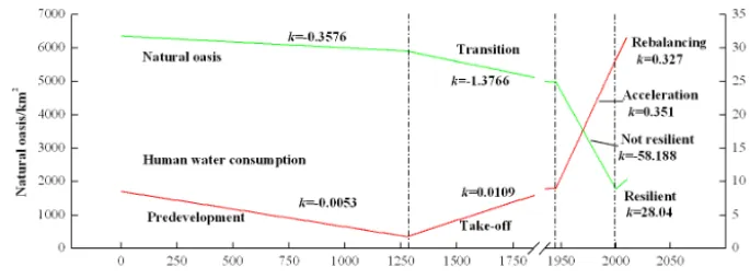
A transition can be measured and assessed by indicators that could be variables with actual physical meanings, or their surrogates. In this study, we used human water con-sumption and natural oasis area as indicators to understand the evolutionary processes of the human–water relationships in the HRB over the past 2000 years. Human water consump-tion, the difference between evapotranspiration and precipi-tation in cultivated land areas, reflects the consequence of human societal development for water cycles. The area of natural oases reflects water supporting the environment. We used the direction and rate of change (k)of these two indi-cators over time to divide the human–water relationship into different development stages. Both the natural oasis area and human water consumption were obtained using the methods above.
3 Results
3.1 Reconstructed precipitation (P) in midstream and downstream reaches
pre-Figure 3. (a) Yang et al.’s (2014) annual precipitation reconstruction for the Qilian Mountains over the last 2000 years, with 50 year
smooth-ing. (b) Qin et al.’s (2010) annual streamflow reconstruction spanning the last millennium with 50 year smoothing at YLX. (c) Our extension of the streamflow from 0 to AD 1000 based on the Yang et al. (2014) precipitation reconstruction and the Qin et al. (2010) streamflow reconstruction.
cipitation in historical periods decreased from the midstream to downstream reaches, was least in the Han Dynasty, and was similar to the present level in the Tang and Ming dynas-ties.
3.2 Reconstructed streamflow flowing into midstream reaches (Rin)
The streamflow reconstruction of Qin et al. (2010) was used to extend the measured streamflow reconstruction, and the streamflow reconstruction of Yang et al. (2012) was used to validate it. It was found that the streamflow record recon-structions obtained by Yang et al. (2012), Qin et al. (2010), and Kang et al. (2002) for the period AD 1000–2000 are gen-erally consistent; however, discrepancies occurred around the years 1290, 1530, 1690, 1840 and 1910. The streamflow re-constructions by Yang et al. (2012) and Qin et al. (2010) were more consistent with the changes in regional humidity sug-gested by paleoclimate results for this region. The paleocli-matic series were derived from tree rings from living trees or archaeological woods in the Qilian Mountains and the Ti-betan Plateau (Yang et al., 2014; Sheppard et al., 2004; Shao et al., 2010), sediments in Qinghai Lake (Shen et al., 2001), and ice cores in Dunde (Liu et al., 1998). Therefore, these two reconstructions were considered to be the more reason-able ones.
It is known that the annual streamflow at YLX and mean precipitation in the Qilian Mountains region changed con-sistently over the past 50 years (Xiao and Xiao, 2008). It was found that precipitation reconstructions of Yang et al. (2014) (Fig. 3a) and streamflow reconstructions of Qin et al. (2010) (Fig. 3b) changed consistently in the last 1000 years. We derived a linear relationship between them as
follows:RQin et al. (2010)=0.2771×PYang et al. (2014)+80.632. We used this relationship to extend the streamflow recon-struction back to the period 0 to AD 1000 at YLX (Fig. 3c). The extended streamflow reconstruction is consistent with the streamflow reconstruction of Yang et al. (2012) for the period from AD 575 to 1000. Over the whole study period, the reconstructed streamflows into midstream areas (Rin) varied between about 2.6 and 4.0 billion m3per year. Stream-flow peaked in recent years due to abundant precipitation to-gether with glacier melt and snowmelt in the upstream areas due to rises in temperature.
3.3 Reconstructed historical land use and land cover The reconstructions of land use for the seven historical pe-riods and three land use maps for 1975, 2000 and 2010 ob-tained by image interpretation are shown in Fig. 4. The ar-eas of cultivated oases changed significantly over historical periods. It was large in the Han Dynasty, and then gradually decreased in area until the Yuan Dynasty. From the Ming Dy-nasty, it increased gradually, and finally reached a peak in the period of modern China. The cultivated areas were mainly distributed in the downstream area of the basin in the first period, and then moved upstream, finally ending up focused on the middle reaches. This might suggest that land reclama-tion was directly affected by the available water resources. 3.4 Validation of derivedRoutwith the reconstructed
evolution of the terminal lakes
[image:7.612.115.483.65.245.2]Figure 4. Land use reconstructions in historical periods and land use through image interpretation in recent periods in midstream and
downstream areas of the HRB. (It should be noted that the grassland, forest and water or wetland were combined with the natural oases, and the farmland and built-up land were combined with cultivated oases in the land use in 1975, 2000 and 2010.)
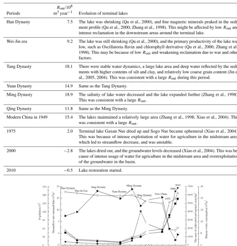
use. The reconstruction of the evolution of the lake, based on lithological, geochemical and mineralogical data from the lacustrine sediment profile sequences in terminal lakes, to-gether with some interpretation, is also described in Table 2. There are relatively good relationships between the input volumes of water to the terminal lakes (Rout)and the evo-lution of the terminal lakes in historical periods. The input of water to terminal lakes was not only determined by the streamflow from upstream, but was also affected by land use in the midstream and downstream areas of the basin. When the streamflow from the upstream area was high and the culti-vation activity in the middle stream was not intense, the input of water to terminal lakes was high, such as during the Tang and Ming dynasties, and vice versa. This was reflected by the pigmentation and organic carbon content of the sediments of the terminal lakes (Qu et al., 2000; Zhang et al., 1998). Af-ter the turn of the twenty-first century,Routbecame negative, which meant that there was a deficit in groundwater recharge because of over-extraction of water for irrigation to meet the need for food (Wei, 2013).
3.5 Reconstructed catchment water balance in the past 2000 years
We reconstructed the catchment water cycles in the HRB for the past 2000 years from the precipitation reconstruction (P ) in midstream and downstream areas, the streamflow recon-struction (Rin), land use reconstruction, evapotranspiration reconstruction (E)and the derived streamflow reconstruction into terminal lakes (Rout). Comparison of the reconstructed
lake condition using the sediment record andRout(Table 2) shows that the reconstructed water cycles reasonably reflect variations in the water balance partitioning in the HRB over the past 2000 years.
Table 2. The input volumes of water to the terminal lakes (Rout)and evolution of the terminal lakes in historical periods.
Rout/108
Periods m3year−1 Evolution of terminal lakes
Han Dynasty 7.5 The lake was shrinking (Qu et al., 2000), and fine magnetic minerals peaked in the sedi-ment profile (Qu et al., 2000; Zhang et al., 1998). This might be affected by lowRoutand
intense reclamation in the downstream areas around the terminal lake.
Wei-Jin era 9.2 The lake was still shrinking (Qu et al., 2000), and the primary productivity of the lake was low, such as Oscillatoria flavin and chlorophyll derivative (Qu et al., 2000; Zhang et al., 1998). This may be because of lowRoutand weakening reclamation due to war and other
factors.
Tang Dynasty 18.1 There were stable water dynamics, a large lake area and deep water reflected by the sedi-ments with higher contents of silt and clay, and relatively low coarse grain content (Jin et al., 2005, 2004). This was consistent with a largeRoutduring this period.
Yuan Dynasty 14.9 Same as the Tang Dynasty.
Ming Dynasty 18.9 The salinity of lake water decreased and the lake expanded further (Zhang et al., 1998). This was consistent with a largeRout.
Qing Dynasty 11.8 Same as the Ming Dynasty.
Modern China in 1949 15.4 The lakes maintained a relatively large area (Zhang et al., 1998; Xiao et al., 2004). This was consistent with a largeRout.
1975 2.0 Terminal lake Gaxun Nur dried up and Sogo Nur became ephemeral (Xiao et al., 2004). This was because of intense exploitation of water for agriculture in the midstream area, which led to streamflow decrease, and was unstable.
2000 −2.8 The lakes dried out, and the groundwater levels decreased (Xiao et al., 2004). This was be-cause of intense usage of water for agriculture in the midstream area and overexploitation of the groundwater in the basin.
[image:9.612.56.536.87.587.2]2010 −0.5 Lake restoration started.
Figure 5. Changes in elements of the reconstructed catchment water balance over the past 2000 years in the midstream and downstream
areas.
3.6 Determination of the development stages of evolutionary processes of human–water relationships
Human water consumption and natural oasis areas changed at different rates (k)in different periods (Fig. 5). Based on their rates of change with time, we divided the evolutionary
Figure 6. The development stages of evolutionary processes of human–water relationships.
The predevelopment phase started after the Han Dynasty. In the Han Dynasty, an unprecedented expansion of man-made cultivated areas based on oases occurred that were associated with defence needs, immigration and settling of farms, which changed the production mode from nomadic herding into settled farming (Cheng et al., 2011). It also cor-responded to the warm and humid climate in the early west-ern Han Dynasty (Ren et al., 2010; Xie et al., 2009). How-ever, in the late eastern Han Dynasty, agricultural produc-tion levels declined due to populaproduc-tion loss and damage to water conservation facilities after long-term warfare. From the southern and northern dynasties (420–581) to the Yuan Dynasty (1271–1368), the people led nomadic lifestyles, and the Hexi corridor was in a state of frequent war and dy-nastic change. The HRB land use was primarily pastoral, as most agricultural oases were abandoned (Li, 1998; Xie et al., 2013). In this predevelopment stage of about 1500 years, the population was stable, and cultivated area was small and fo-cused on downstream areas. As a result, humans had few im-pacts on the water system, and the area of natural oasis area did not change significantly.
After the Ming Dynasty, when agricultural civilization re-vived, the evolution of the human–water relationships in the HRB entered the take-off stage. During this phase, oasis reclamation activities were promoted and moved upstream to the midstream area (Wu, 2000). In the middle of the Qing Dynasty, the Hexi Corridor was politically stable and free of wars, and the basic requirements for agricultural devel-opment were provided by the government, including seeds, cattle, and steel farming implements. This led to expansion of the cultivated land and agricultural development. There-fore, the population increased quickly (Shi, 2010). At the same time, irrigation technology hardly changed, and with the area of cultivated land expanding, water resource utiliza-tion became increasingly intense (Wang, 2003). It was also during this period that disputes about water arose (Cheng et al., 2011; Shen and He, 2004). This phase was relatively short, lasting about 580 years. During this phase, human wa-ter consumption increased at a rate of 1.09 million m3 per year on average, and the area of natural oases decreased at an
average rate of 1.38 km2per year. Human intervention in the water system was gradually increasing.
After modern China was founded in 1949, societal devel-opment in the HRB moved into the acceleration stage. Dur-ing this stage, the population, the area of cultivated land and human water consumption increased sharply, especially af-ter the green revolution of the 1960s and China’s reform and opening-up in 1978. In addition, food self-sufficiency dom-inated Chinese agricultural and water resource development policy. Many wells, reservoirs and channels were built during this stage. This stage was the shortest, only 50 years long, but the human water consumption increased at an alarming rate of 35.1 million m3per year, and the area of natural oasis area decreased at an average rate of 58 km2 per year. The influ-ence of human activities on water resources reached its peak and the environment was seriously degraded as natural wet-lands, rivers, and lakes dwindled rapidly (Xiao et al., 2004).
4 Discussions and conclusions
This paper represents an attempt to reveal the evolution-ary processes of the human–water relationships in the HRB over the past 2000 years. We quantitatively analyzed the dynamics of coupled human and hydrological systems as well as the associated climatic and ecological changes in the past 2000 years within the HRB by reconstructing the catchment water balance. Based on transition theory, we di-vided the evolution of the human–water relationship into four stages, which are predevelopment (206 BC–AD 1368), take-off (AD 1368–1949), acceleration (AD 1949–2000), and re-balancing (after AD 2000).
This study provides new understandings of how soci-etal drivers and socisoci-etal responses over time interact and feed back with catchment water cycles over a timescale of 2000 years. The pace of the evolutionary process varied. The predevelopment stage lasted for 1500 years, and the take-off period was shorter, at only 580 years. After that, in a pe-riod of only 50 years, the acceleration pepe-riod occurred when the population increased from 0.5 to 1.9 million and the area of cultivated oases expanded by 3649 km2, which was about double that at the beginning of the acceleration stage. Hu-man water consumption increased by 1.9 billion m3per year, resulting in a doubling of water use over the stage. This re-sulted in volumes of water from midstream areas flowing into terminal lakes, decreasing from more than 1 billion m3 per year to 0. This became the trigger for a sustainability transition in the HRB in 2000 when a water reallocation scheme was implemented. This meant that the evolutionary processes of human–water relationships in the basin entered a new stage: rebalancing. This understanding of the dynam-ics of transitions will assist policy makers in identifying man-agement practices that require improvement by understand-ing how today’s conditions and problems were created in the past. It could also help integrate management of land and wa-ter use to allow for more sustainable catchment management to combat desertification in this region.
An important part of the paper was reconstructing the catchment water balance. This relied on a range of data sources, including paleo-climates and paleo-environments reflected by dendrochronology, ice cores, lake sediments and historical drought and flood sequences, a historical atlas of China, remote sensing images and instrumented streamflow and climate data. The resulting reconstructed water balance was consistent with the dynamics of the terminal lakes in the HRB over the past 2000 years. The reconstruction provided a basis for generating baseline data against which to evaluate recent changes, for investigating the impact of human soci-eties on hydrological systems in historical contexts, and for generating data sets for improving models of hydrological systems over timescales that exceed the length of the instru-mented record (Savenije et al., 2013).
There are some important limitations on the methods and with the data collection and analysis. Several assumptions
and uncertainties in the 2000 year hydrological reconstruc-tion exist due to lack of data. Values forE0in the historical periods were assumed to be the same as in recent periods, which is reasonable given that the variation in average tem-perature was less than 2◦. Values forwmay vary among dif-ferent land use types and could change with time depending on the type and intensity of crops in historical periods; how-ever, due to the lack of data, the value of w for the HRB was set at 3.5. For the same reason, irrigation was set at 500 mm per year for the whole historical period. There was also some inconsistency between the data extracted from the different proxy materials; for example, the streamflow recon-structions by Yang et al. (2012), Qin et al. (2010), and Kang et al. (2002) using tree rings were not completely consistent. There were limitations due to the available data’s represen-tativeness of locations; for example, the data from tree rings only focused on the upstream area of the mainstream areas of the Heihe River, and the samples of lake sediment mainly focused on the terminal lake Sogo Nur. Problems of represen-tativeness of data in various time periods and varying resolu-tions of data also occurred. For example, the land use maps only covered several periods, the tree ring dating can be spe-cific to the annual scale, and the information from ice cores and lake sediment profiles was on the century scale.
The transitions seen from the four stages of evolutionary processes of human–water relationships in the HRB did not follow the standard theoretical processes. Stabilization, a ty-pological phase in the standard transition process, did not ap-pear. In addition, there were large differences in the rates and scales of changes and the period of time over which they oc-curred. Some further theoretical research is needed to explain the transition pattern, but this result shows that transitions have no fixed pattern. This paper provides a path toward an analytical approach to water-related societal transitions that should be, on the one hand, strongly attached to social sci-ence theory, and, on the other hand, firmly based on formal hydrological modeling.
Acknowledgements. This work was funded by the International
Science & Technology Cooperation Program of China (project no. 2013DFG70990), the Natural Science Foundation of China (project nos. 91125007, 91125025, 91225302, and 91225301), the Australian Research Council (project nos. DP120102917 and FT130100274), the Commonwealth of Australia under the Australia-China Science and Research Fund (project no. AC-SRF800), the National Science and Technology Support projects (project no. 2011BAC07B05), and the technology innovation team of the China Academy of Science (Cross and Cooperation). We thank two anonymous reviewers for their comments on an earlier version of this paper.
References
Budyko, M. I.: Climate and Life, Academic, San Diego, CA, 508 pp., 1974.
Carpenter, S. R., Cole, J. J., Pace, M. L., Batt, R., Brock, W. A., Cline, T., Coloso, J., Hodgson, J. R., Kitchell, J. F., Seekell, D. A., Smith, L., and Weidel, B.: Early warnings of regime shifts: a whole-ecosystem experiment, Science, 332, 1079–1083, 2011. Chen, L.: Land desertification and its control strategies in the low
reaches of the Heihe River, J. Nat. Resour., 1, 35–43, 1996. Cheng, H., Huang, Y., and Zhao, L.: The human activity in Hexi
Corridor during historical time, available at: http://www.paper. edu.cn (last access: 5 April 2014), 2011.
Elshafei, Y., Sivapalan, M., Tonts, M., and Hipsey, M. R.: A pro-totype framework for models of socio-hydrology: identifica-tion of key feedback loops and parameterisaidentifica-tion approach, Hy-drol. Earth Syst. Sci., 18, 2141–2166, doi:10.5194/hess-18-2141-2014, 2014.
Falkenmark, M. and Lannerstad, M.: Consumptive water use to feed humanity – curing a blind spot, Hydrol. Earth Syst. Sci., 9, 15– 28, doi:10.5194/hess-9-15-2005, 2005.
Fu, B.: On the calculation of the evaporation from land surface, Sci. Atmos. Sin., 5, 23–31, 1981.
Geels, F. W.: Technological transitions as evolutionary reconfigura-tion processes: a multi-level perspective and a case-study, Res. Policy, 31, 1257–1274, 2002.
Holmes, J. A., Cook, E. R., and Yang, B.: Climate change over the past 2000 years in Western China, Quatern. Int., 194, 91–107, 2009.
Jin, H., Xiao, H., Sun, L., Zhang, H., Sun, Z., and Li, X.: Vicissitude of Sogo Nur and environmental-climatic change during last 1500 years, Sci. China Ser. D, 47, 61–70, 2004.
Jin, H., Xiao, H., Zhang, H., and Sun, Z.: Evolution and climate changes of the Juyan Lake revealed from grain size and geo-chemistry element since 1500aBP, J. Glaciol. Geocryol., 27, 233–240, 2005.
Kallis, G.: Coevolution in water resource development the vicious cycle of water supply and demand in Athens, Greece, Ecol. Econ., 69, 796–809, 2011.
Kang, X., Cheng, G., Kang, E., and Zhang, Q.: Mountainous runo_reconstruction of Heihe River during past 1000 years us-ing tree-rus-ing, Sci. China Ser. D, 32, 49–53, 2002.
Li, B.: An investigation and study on the desertification of the an-cient oases from Han to Tang dynasties in the Hexi corridor, Acta Geogr. Sin., 53, 106–115, 1998.
Liu, K., Yao, Z., and Thompson, L. G.: A pollen record of Holocene climatic changes from the Dunde ice cap, Qinghai-Tibetan Plateau, Geology, 26, 135–138, 1998.
Liu, Y., Tian, F., Hu, H., and Sivapalan, M.: Socio-hydrologic perspectives of the co-evolution of humans and water in the Tarim River basin, Western China: the Taiji-Tire model, Hy-drol. Earth Syst. Sci., 18, 1289–1303, doi:10.5194/hess-18-1289-2014, 2014.
Lowry, D. P. and Morrill, C.: Changes in the Global Hydrolog-ical Cycle: Lessons from Modeling Lake Levels at the Last Glacial Maximum, American Geophysical Union, Fall Meeting, San Francisco, California, USA, 5–9 December 2011, 2011. Montanari, A., Young, G., Savenije, H., Hughes, D., Wagener,
T., Ren, L., Koutsoyiannis, D., Cudennec, C., Toth, E., and Grimaldi, S.: “Panta Rhei – Everything Flows”: change in
hy-drology and society – the IAHS Scientific Decade 2013–2022, Hydrolog. Sci. J., 58, 1256–1275, 2013.
Pataki, E., Carreiro, M., Cherrier, J., Grulke, E., Jennings, V., Pincetl, S., Pouyat, V., Whitlow, H., and Zipperer, C.: Coupling biogeochemical cycles in urban environments: ecosystem ser-vices, green solutions, and misconceptions, Front. Ecol. Envi-ron., 1, 27–36, doi:10.1890/090220, 2011.
Qin, C., Yang, B., Burchardt, I., Hu, X., and Kang, X.: Intensi-fied pluvial conditions during the twentieth century in the inland Heihe River Basin in arid northwestern China over the past mil-lennium, Global Planet. Change, 72, 192–200, 2010.
Qu, W., Wu, R., Wang, S., and Zhang, Z.: Sedimentary pigment and its environmental signification of East Juanyanhai in Inner Mongolia since the past 2600 years, Acta Sendiment. Sin., 48, 13–17, 2000.
Ren, Z., Lu, Y., and Yang, D.: Drought and flood disasters and re-building of precipitation sequence in Heihe River basin in the past 2000 years, J. Arid Land Resour. Environ., 24, 91–95, 2010. Röckstrom, J., Karlberg, L., Wani, S. P., Barron, J., Hatibu, N., Oweis, T., Bruggeman, A., Farahanie, J., and Zhu, Q.: Manag-ing water in rainfed agriculture – the need for a paradigm shift, Agr. Water Manage., 97, 543–550, 2010.
Rotmans, J.: Societal Innovation: Between Dream and Reality Lies Complexity, DRIFT Research Working Paper, Erasmus Research Institute of Management (ERIM), Rotterdam, the Netherlands, doi:10.2139/ssrn.878564, 2005.
Saito, K., Hirai, M., and Yonekura-Sakakibara, K.: Decoding genes with coexpression networks and metabolomics –“majority report by precogs”, Trends Plant Sci., 13, 36–43, 2008.
Savenije, H. H. G., Hoekstra, A. Y., and van der Zaag, P.: Evolving water science in the Anthropocene, Hydrol. Earth Syst. Sci., 18, 319–332, doi:10.5194/hess-18-319-2014, 2014.
Shao, X., Xu, Y., Yin, Z.-Y., Liang, E., Zhu, H., and Wang, S.: Climatic implications of a 3585-year tree-ring width chronology from the northeastern Qinghai-Tibetan Plateau, Quaternary Sci. Rev., 29, 2111–2122, 2010.
Shen, J., Zhang, E., and Xia, W.: Records from lake sediments of the Qinghai Lake to mirror climatic environmental changes of the past about 1000 years, Quatern. Sci., 21, 508–513, 2001. Shen, M. and He, L.: Comparison of new and old equal water
regime in Heihe River basin, Yellow River, 26, 27–29, 2004. Sheppard, P., Tarasov, P., Graumlich, L., Heussner, K.-U., Wagner,
M., Österle, H., and Thompson, L.: Annual precipitation since 515 BC reconstructed from living and fossil juniper growth of northeastern Qinghai Province, China, Clim. Dynam., 23, 869– 881, 2004.
Shi, J.: Integrating humanistic and scientific studies to reveal the changes of Khara Khoto, Studies in humanity and environment of Khara Khoto, in: Proceedings of international symposium on the humanity and environment of Khara Khoto region, Renmin University of China Press, Beijing, 1–4, 2007.
Shi, L.: Study on the spatio-temporal process of oasisization and desertification in the period of the Ming, Qing dynasty and Re-public of China in the middle reaches, MD thesis, Lanzhou Uni-versity, Lanzhou, 2010.
Sivapalan, M., Blöschl, G., Zhang, L., and Vertessy, R.: Downward approach to hydrological prediction, Hydrol. Process., 17, 2101– 2111, 2003.
Sivapalan, M., Savenije, H. H., and Blöschl, G.: Socio-hydrology: a new science of people and water, Hydrol. Process., 26, 1270– 1276, 2012.
Tàbara, J. D. and Ilhan, A.: Culture as trigger for sustainability tran-sition in the water domain: the case of the Spanish water policy and the Ebro river basin, Reg. Environ. Change, 8, 59–71, 2008. Tan, Q.: The Historical Atlas of China, China Cartographic
Publish-ing House, BeijPublish-ing, 1996.
Thompson, S. E., Sivapalan, M., Harman, C. J., Srinivasan, V., Hipsey, M. R., Reed, P., Montanari, A., and Blöschl, G.: Devel-oping predictive insight into changing water systems: useinspired hydrologic science for the Anthropocene, Hydrol. Earth Syst. Sci., 17, 5013–5039, doi:10.5194/hess-17-5013-2013, 2013. Vörösmarty, C. J., McIntyre, P. B., Gessner, M. O., Dudgeon, D.,
Prusevich, A., Green, P., Glidden, S., Bunn, S. E., Sullivan, C. A., Reidy Liermann, C., and Davies, P. M.: Global threats to hu-man water security and river biodiversity, Nature, 467, 555–563, 2010.
Wang, G., Yang, L., Chen, L., and Jumpei, K.: Impacts of land use changes on groundwater resources in the Heihe River basin, Acta Geogr. Sin., 60, 456–466, 2005.
Wang, G., Xie, Y., Wang, X., Yu, L., and Shi, Z.: Data reconstruc-tion of Heihe River basin cultivated land area prior to the Ming dynasty, Resour. Sci., 35, 362–369, 2013.
Wang, Y.: The development history of water conservancy facilities in Heihe River basin, Gansu Nationalities Press, Lanzhou, 2003. Wei, H.: Groundwater age and sustainability based on process simulation in Zhangye basin, PhD thesis, Cold and Arid Re-gions Environment and Engineering Research Institute, Chinese Academy of Sciences, Lanzhou, 2013.
Wimmer, A.: Models, methodologies, and metaphors on the move, in: Understanding Change Models, Methodologies, and Metaphors, edited by: Wimmer, A. and Kössler, R., Palgrave MacMillan, London, England, 2006.
Woodhouse, A., Gray, T., and Meko, M.: Updated streamflow re-constructions for the Upper Colorado River Basin, Water Resour. Res., 40, W05415, doi:10.1029/2005WR004455, 2006. Wu, X.: Historical variance of the ecological environment in the
in-land river area along the Hexi corridor, J. Lanzhou Univ. (Social Sciences), 28, 46–49, 2000.
Xiao, S. and Xiao, H.: Farming-grazing vicissitude and man–land relation evolution of Ejin Banner in historical period, J. Desert Res., 24, 449–451, 2004.
Xiao, S. and Xiao, H.: Advances in the study of the water regime process and driving mechanism in the Heihe River basin, Adv. Earth Sci., 23, 748–755, 2008.
Xiao, S., Xiao, H., Zhou, M., Si, J., and Zhang, X.: Water level change of the west Juyan Lake in the past 100 years recorded in the tree ring of the shrubs in the lake banks, J. Glaciol. Geocryol., 26, 557–562, 2004.
Xie, Y.: Dataset of cultivated oasis distribution in the Heihe River Basin during the historical period, Heihe Plan Science Data Cen-ter, Lanzhou, China, doi:10.3972/heihe.092.2013.db, 2013. Xie, Y., Chen, F., and Qi, J.: Past desertification processes of Minqin
Oasis in arid China, Int. J. Sust. Dev. World, 16, 260–269, 2009. Xie, Y., Wang, X., Wang, G., and Yu, L.: Cultivated land distribution simulation based on grid in middle reaches of Heihe River basin in the historical periods, Adv. Earth Sci., 28, 71–78, 2013. Yang, B., Qin, C., Shi, F., and Sonechkin, D. M.: Tree ring-based
an-nual streamflow reconstruction for the Heihe River in arid north-western China from AD 575 and its implications for water re-source management, Holocene, 22, 773–784, 2012.
Yang, B., Qin, C., Wang, J., He, M., Melvin, T. M., Osborn, T. J., and Briffa, K. R.: A 3,500-year tree-ring record of annual pre-cipitation on the northeastern Tibetan Plateau, P. Natl. Acad. Sci. USA, 111, 2903–2908, 2014.
Yang, D., Sun, F., Liu, Z., Cong, Z., Ni, G., and Lei, Z.: Analyz-ing spatial and temporal variability of annual water-energy bal-ance in nonhumid regions of China using the Budyko hypothesis, Water Resour. Res., 43, W04426, doi:10.1029/2006WR005224, 2007.
Zhang, L., Dawes, W., and Walker, G.: Response of mean annual evapotranspiration to vegetation changes at catchment scale, Wa-ter Resour. Res., 37, 701–708, 2001.
Zhang, L., Hickel, K., Dawes, W., Chiew, F. H., Western, A., and Briggs, P.: A rational function approach for estimating mean annual evapotranspiration, Water Resour. Res., 40, W02502, doi:10.1029/2003WR002710, 2004.
Zhang, L., Pang, B., Xu, Z., and He, R.: Impacts of climate change and LULC on hydrological processes in the Gulang River basin, Sounth-to-North Water Transfers and Water Science & Technol-ogy, 12, 42–46, 2014.
Zhang, Z., Wu, R., Wang, S., Xia, W., Wu, Y., and Qu, W.: Environ-mental changes recorded by lake sediments from East Juyanhai Lake in Inner Mongolia during the last 2600 years, J. Lake Sci., 10, 44–51, 1998.
Zhao, L. and Ji, X.: Quantification of transpiration and evaporation over agricultural field using the FAO-56 Dual Crop Coe_cient Approach – A case study of the maize field in an oasis in the middlestream of the Heihe River Basin in northwest China, Sci-ent. Agr. Sin., 43, 4016–4026, 2010.
Zheng, J. and Wang, S.: Assessment on climate change in China for the last 2000 years, Acta Geogr. Sin., 60, 21–31, 2005.
Zheng, J., Shao, X., Hao, Z., and Ge, Q.: An overview of research on climate change in China during the past 2000 years, Geogr. Res., 29, 1561–1570, 2010.