University of Tennessee, Knoxville
Trace: Tennessee Research and Creative
Exchange
Masters Theses Graduate School
5-2013
Faunal Analysis of Sachsen Cave Shelter: A
Zooarchaeological Approach to Site Function
Meagan Elizabeth Dennison mdenniso@utk.edu
This Thesis is brought to you for free and open access by the Graduate School at Trace: Tennessee Research and Creative Exchange. It has been accepted for inclusion in Masters Theses by an authorized administrator of Trace: Tennessee Research and Creative Exchange. For more information, please contacttrace@utk.edu.
Recommended Citation
Dennison, Meagan Elizabeth, "Faunal Analysis of Sachsen Cave Shelter: A Zooarchaeological Approach to Site Function. " Master's Thesis, University of Tennessee, 2013.
To the Graduate Council:
I am submitting herewith a thesis written by Meagan Elizabeth Dennison entitled "Faunal Analysis of Sachsen Cave Shelter: A Zooarchaeological Approach to Site Function." I have examined the final electronic copy of this thesis for form and content and recommend that it be accepted in partial fulfillment of the requirements for the degree of Master of Arts, with a major in Anthropology.
Walter E. Klippel, Major Professor We have read this thesis and recommend its acceptance:
Jan F. Simek, Jefferson Chapman, Jay D. Franklin
Accepted for the Council: Dixie L. Thompson Vice Provost and Dean of the Graduate School (Original signatures are on file with official student records.)
Faunal Analysis of Sachsen Cave Shelter: A Zooarchaeological Approach to Site Function
A Thesis Presented for the Master of Art
Degree
The University of Tennessee, Knoxville
Meagan Elizabeth Dennison May 2013
ii
Copyright © 2013 Meagan Elizabeth Dennison All Rights Reserved
iii
This thesis is dedicated to my loving husband, Jeff, who drove to Knoxville every weekend for three years while we lived apart during the course of this thesis research. The sacrifices you have
made will never go underappreciated.
This thesis is also dedicated to all those who helped create the archaeological record at Sachsen Cave Shelter.
iv
Acknowledgements
The research presented in this thesis was by no means an individual endeavor and there are many individuals and groups to thank. First, I extend my deepest gratitude to my committee members. My chair, Dr. Walter Klippel, was very patient and helpful during the course of this thesis research and was always available for my many questions. I also extend my gratitude to Dr. Klippel for being a wonderful advisor and mentor. Dr. Jan Simek was an invaluable addition to my committee and many thanks are owed to him for asking the hard questions and
encouraging me to think about the larger implications of my research. Dr. Jefferson Chapman provided expert knowledge of the prehistoric inhabitants of East Tennessee and was a very positive and encouraging. I offer him my most sincere gratitude for agreeing to serve on my committee. And finally, a huge thank you is owed to Dr. Jay Franklin for introducing me to the world of archaeology, prehistory and the rock shelters on the Cumberland Plateau. Dr. Franklin also provided archaeological materials, excavation notes, student volunteers, and two field schools for the completion of this thesis research. I greatly appreciate all his contributions to this thesis research. Many thanks are also owed to these ETSU field school students, volunteers and governor school students who aided in excavations and artifact processing throughout the years.
I am very appreciative and thankful for the hospitality of the Sachsen Cave Shelter landowners, Malcolm and Harriet Colditz. Malcolm and Harriet have always been more than accommodating to the groups of students, including myself, who have worked on their property. They have provided me with lodging, meals, company and access to their property many times throughout the course of this thesis research, and I can never thank them enough for their continued support.
v
Many other individuals provided support and advice that accompanies the research presented herein. Dr. Heli Maijanen and Dr. Lee Jantz provided access to human comparative skeletons. Both were always available and more than willing to help me confirm or deny my suspicions. Dr. Barbara Heath and Brad Hatch allowed me access to the wet lab located in South Stadium Hall for processing flotation samples. Many thanks are owed to them for their patience with my many sediment clogs and floods. I would also like to acknowledge Dr. Gerald Schroedl for making Southeastern Archaeology fun and for always being available for questions and references. I extend my gratitude to the Patricia Black Fund, Department of Anthropology, University of Tennessee and the University of Tennessee Knoxville Graduate Student Travel Award for funding different aspects of this thesis research.
I am extremely grateful for the people associated with the Archaeological Research Laboratory. Howard Cyr and Calla McNamee helped me tremendously with the bone
preservation aspect of this thesis. They provided equipment and references, and were always available to discuss soil chemistry and bone dissolution. Dr. Kandi Hollenbach and Dr. Boyce Driskell were important to this project as well – they too provided access to equipment and their own knowledge of hunter-gatherer lifeways. My gratitude is also owed to Dr. Renee Walker who conducted the initial analysis on a sample of faunal remains from the site. Dr. Walker also provided her data and expert knowledge to aid in this thesis research. Lynn Sullivan, Bobby Braly and Jessica Dalton-Carringer provided access and assistance to museum collections used for identifications of dog remains and I am very appreciative of their accommodations. I also extend my gratitude to Gerry Dinkins, Steve Ahlstedt and Matthew Reed for aiding in
vi
Much gratitude is also owed to the anthropology faculty at ETSU: Dr. Lindsay King, Dr. Anthony Cavender, Dr. Melissa Schrift and Dr. William Duncan. These professors encouraged and supported me as I received my undergraduate degree and they each have continued to send their support throughout this the course of this thesis research. Thank you all so much.
Many thanks are owed to Lucinda Langston for producing a plan view map of the site, even though she was in the middle of preparing her own MA thesis. I’d also like to thank
Lucinda for all her support and friendship through the years along with Sierra and Travis Bow. I am very grateful for all the memories I have hiking around in the woods on the Plateau with you all on ridiculously cold days – and having a blast.
My success in graduate school could not have been accomplished without the help of my friends and family. Living far from home is always difficult, but good friends and company can make all the difference. I would like to acknowledge my fellow graduate students for their camaraderie and making graduate school more fun. A big thank you is owed to Katie Lamzik, with whom I shared an office, many beers and cups of coffee, suggestions, advice and
companionship throughout the course of this thesis research. Katie also helped identify many faunal elements along with Ann Ramsey, Lydia Carmody and Callie Roller. Also, many thanks are owed to Andrew Wilkins for assisting me with the XRF analysis.
I could not have completed this research without the loving support of my family. Thank you so much for all you have done for me throughout the years. Special thanks to Caleb for thinking what I do is cool. And lastly, I am truly grateful for the support and encouragement of my husband. Thank you for standing by my side at every step along the way.
vii Abstract
Faunal remains are not often utilized to explore settlement practices and site use by prehistoric hunter-gatherers in the southeastern United States. Instead, lithic reduction sequences and site features are generally relied upon when making these kinds of interpretations. Faunal analysis, however, can offer an additional line of support to these interpretations, especially when seasonal indicators, transport of large animal remains and diversity of species are taken into account. This thesis is an attempt to address the prehistoric use of Sachsen Cave Shelter through the lens faunal analysis. Sachsen Cave Shelter is a large sandstone rock shelter located on the Upper Cumberland Plateau of Tennessee that was utilized by Late Archaic and Woodland peoples. The Late Archaic component of the site is characterized as a residential base camp based on lithic reduction sequences, numerous hearth features, dense artifact assemblages and several nutting stones and steatite stone bowl fragments. This thesis presents a detailed overview of the faunal assemblage of the site in an attempt to both elaborate this interpretation of site function for the Late Archaic component as well as discuss site use during the Woodland Period. It is expected that the faunal assemblage will reflect site use based on the established material correlates of a base camp (i.e. high species diversity, whole carcass transportation of large animals and evidence for multiple and diverse activities). Recovery bias and bone preservation were addressed as well, as these could have profound effects on interpretations of site function. The results indicate that site function is reflected in the faunal assemblages of this site, and is dependent on the season of occupation and subsistence/settlement strategy.
viii
Table of Contents
Chapter 1: Introduction ... 1
Site Function – Definitions and Previous Research ... 1
Goals and Expectations ... 5
Chapter 2: Background ... 7
Physiographic Setting ... 7
Environmental Setting ... 8
Chapter 3: Culture History ... 12
The Paleoindian Period (14,800 – 11,500 cal. BP) ... 12
The Archaic Period (11,500 – 3,200 cal. BP) ... 12
The Woodland Period (3,200 – 1,000 cal. BP) ... 16
The Mississippian Period (A.D. 1,000 – 1,500) ... 19
Chapter 4: Sachsen Cave Shelter ... 21
2008 Summary of Excavations ... 25 2010 Summary of Excavations ... 33 2011 Summary of Excavations ... 34 Summary of Excavations ... 35 Chapter 5: Methods ... 39 Faunal Sampling ... 39
Faunal Identification and Quantification... 45
Faunal Modification ... 49
Heat Alteration ... 49
Butchering ... 50
Bone Tools and Worked Bone ... 51
Surface Degradation ... 51
Gnaw Marks and Digestion ... 53
Bone Preservation ... 53
Chapter 6: Results ... 63
2.5cm Recovered Faunal Material ... 63
ix
.16cm Recovered Faunal Material ... 111
Diversity Calculations ... 113
Bone Preservation Results ... 115
Chapter 7: Discussions and Conclusions ... 118
Discussion of Site Function... 118
Addressing Bias ... 118 Late Archaic ... 123 Woodland... 126 Regional Context ... 127 Conclusions ... 129 Appendices ... 142
Appendix 1: XRF Analysis Results Test Unit 31 ... 143
Appendix 2: Sachsen Cave Shelter Workbook ... 150
x List of Tables
Table 1: Proveniences sampled for 2.5cm and .32cm screening and flotation and estimated
amount of total sediment excavated. ... 28
Table 2: AMS dates S32. ... 31
Table 3: Associated context for all proveniences excavated at Sachsen Cave Shelter ... 38
Table 4: Proveniences sampled and sample sizes for .32cm recovered faunal material. ... 43
Table 5: Flotation samples used for recovery of fauna through .16cm mesh. ... 44
Table 6: Sediment samples from North Wall, TU 31 subjected to XRF analysis ... 61
Table 7: Taxa counts, weights and modification for all 2.5cm recovered material analyzed by the author………. 65 Table 8: Walker Data, Late Archaic component. ... 68
Table 9: Modifications recorded for all 2.5cm recovered bone. Walker 2010 data incorporated. 70 Table 10: Proveniences and weight for faunal remains recovered from unknown context, 2.5cm. ... 74
Table 11: Taxa counts and weights for faunal remains recovered from unknown context, 2.5cm. ... 75
Table 12: Taxa counts and weights for faunal material recovered from disturbed context, 2.5cm. ... 78
Table 13: Taxa counts and weights for faunal remains recovered from Woodland Context, 2.5cm. ... 87
Table 14: Taxa counts and weights for faunal remains recovered from Woodland/Archaic context. ... 94
Table 15: Taxa list for Archaic Context, Dennison/Walker data combined. ... 97
Table 16: .32cm results, by context. ... 109
Table 17: .16cm Results ... 112
Table 18: Diversity calculations and species used, by context, 2.5cm and .32cm combined, Walker/Dennison combined. ... 114
xi List of Figures
Figure 1: Sachsen Cave Shelter. ... 22
Figure 2: Central portion and excavations at Sachsen Cave Shelter.. ... 23
Figure 3: Evidence of water flow... 24
Figure 4: Site map, Sachsen Cave Shelter. ... 26
Figure 5: S32 Stratigraphy ... 30
Figure 6: Method of hand sorting .32cm recovered artifacts. ... 41
Figure 7: Estimated percentages of excavated sediment subject to various screen sizes and percentage of total excavated sediment subject to faunal analysis ... 42
Figure 8: Evidence of flowing and dripping water. ... 55
Figure 9: Test Unit 31, North Wall showing column sample taken for sediment analysis.. ... 60
Figure 10: Distribution of animal taxa, Sachsen Cave Shelter, Dennison & Walker data combined. ... 64
Figure 11: Distribution of white-tailed deer elements (NISP) from disturbed context. ... 83
Figure 12: White-tailed deer element distribution, Woodland context... 89
Figure 13: Raccoon canine pendant. Late Archaic context.. ... 100
Figure 14: White-tailed deer element distribution, Archaic context... 102
Figure 15: Proportions of .32cm recovered taxa, Woodland and Late Archaic ... 108
Figure 16: Microartifacts by weight (g) with depth, TU 31 ... 111
Figure 17: Proportions of taxa recovered from .16cm mesh ... 113
1
Chapter 1: Introduction
Zooarchaeological research is one of the most important, diverse and specialized branches of archaeological inquiry. This subfield of archaeology is broadly concerned with the relationship of past humans with their environments (Reitz and Wing 2008:1). Faunal analyses can yield information concerning subsistence practices, mobility of peoples, the processes of domestication, differential social statuses, changing environments, and use of animal byproducts for utilitarian items (Davis 1987; Reitz and Wing 2008).
This thesis is concerned with exploring subsistence patterns and how they relate to settlement patterns and mobility of the Late Archaic and Woodland inhabitants of the Upper Cumberland Plateau (UCP) of Tennessee. This type of research is not novel by any means (see below); however, an investigation such as this has never been carried out on the UCP. A sample of faunal remains recovered from a single site on the UCP is analyzed and reported upon here, in an attempt to relate the faunal remains present with the activities conducted at the site in the past which indicate site function. The site is Sachsen Cave Shelter, a large sandstone rock shelter that was used by Late Archaic and Woodland peoples as a habitation site, or base camp. This
determination was based on lithic artifacts, a small sample of the faunal assemblage, and other features of the site (Franklin, et al. 2010).
Site Function – Definitions and Previous Research
Site function is ascribed using Binford’s foragers/collectors model which he established based on several ethnoarchaeological and ethnographical studies (Binford 1980). Binford (1980:5) defines foragers as small family groups that move together seasonally from one resource patch to the next. They utilize base camps intensively, as well as locations away from base camps, often represented by ephemeral use – such as butchering, retooling or resting,
2
snacking or gearing up (Binford 1980:9). Collectors, on the other hand, also live in small family groups, but move less frequently. They are defined by food storage and the creation of more and varied site types on the landscape, such as field camps, stations and caches. They rely on task-groups to bring subsistence related material back to base camps. It should be noted, however, that the forager/collector model is not a fixed designation for any group. The patterns are generally dependent on resource distribution, which vary by season and location, and groups may switch from foraging one season, to collecting in another. The two settlement models overlap, however, in that they both utilize base camps.
The premise of this thesis is therefore established in this model developed by Binford and employed by others in the Southeast (i.e. Anderson and Hansen 1988; Kimball 1996). However, it is recognized that the foragers/collector model is quite linear and may not be suited to address the wide range of mobility practices employed by prehistoric Southeasterners (sensu Chatters 1987). An alternative to this model would be something rooted in Optimal Foraging Theory (OFT) which takes costs and benefits of certain food items into account when discussing hunter-gatherer subsistence behavior (see Winterhalder 1981; Bird and O’Connell 2006). While
employing models from OFT would likely enhance the overall interpretations of this thesis, the focus here will remain on the foragers/collectors model, as this has been the primary mode of inquiry into the prehistoric use of the plateau (c.f. Des Jean and Benthall 1994; Ferguson et al. 1986; Franklin 2002). It is encouraged that future research on this site and other faunal bearing sites on the UCP utilize behavioral models to further explore prehistoric use of the region and subsistence practices.
In order to adequately address aspects of site function, both the archaeological and ethnographic records must be considered. Through middle range theory, archaeologists have
3
been able to better model characteristics of base camps and hunting camps. From his work with the Nunamiut in Northwestern Alaska, Binford (1978) outlined the archaeological correlates of habitation sites and hunting camp sites based on several artifact assemblages, including faunal remains. He later demonstrated that carnivore accumulated assemblages can mimic this type of archaeological patterning (Binford 1981) and therefore careful attention must be given to the natural and cultural taphonomic modifications when analyzing faunal remains. Distinguishing between natural and cultural deposition of faunal remains has been the subject of many studies in other contexts (Binford 1981; Brain 1981; Klein 1989; O'Connell 1992).
Another well studied ethnographic hunting and gathering group is the Hadza of central Africa. Bunn, et al. (1988) suggest that during their dry season and wet season foraging activities, the Hadza create up to five site types, and include base camps, kill sites, butchering sites and snack sites (none of which are mutually exclusive). They found that kill and butchering sites are dominated by axial skeleton parts and base camps have a mix of both axial and
appendicular skeletal parts (Bunn, et al. 1988:438). It should be noted that the Hadza hunt animals much larger than those found in the prehistoric Southeastern United State, aside from black bear and elk (Cervus canadensis). O'Connell, et al. (1988) conducted similar research and suggest that while transportation of specific elements is highly variable, it is patterned by a balance of nutritional utility and processing and transportation costs (O’Connell, et al. 1988:115).
Archaeological studies of kill/butchering sites are common from Paleoindian sites in the western United Sties (Kooyman 2006 et al.; Speth 1983; Wheat 1972 et al.) These sites are typically dominated by one animal species (such as Bos bison) and parts of that animal that are the least efficient to transport (i.e. the axial skeleton). Similar approaches are also popular in
4
Paleolithic and Mesolithic European contexts (e.g. Chase 1986; Moncel 2005 et al.; Straus 2006). Another interesting study of site function utilized stages of production and discard of ostrich eggshell beads to determine settlement patterns of Geelbek Dunes of South Africa during the Middle to Late Stone Age (Kandal 2005). This work demonstrated that longer used sites have more stages of bead production represented, while more ephemerally used sites are dominated by beads in final stages of production and use-life. This thesis research is based on a similar premise – that site function is patterned in all artifact assemblages represented at a particular site. The focus here is on faunal assemblage composition; however, other artifact assemblages will be taken into account as all should be used together when making broad site and regional level interpretations.
Traditionally, determining site function has been carried out through associated features at an archaeological site, spatial patterning and by determining artifact uses (Andrefsky
2005:201; Kimball 1993). More recently, lithic tool and debitage analyses have also been used to establish site function (Carr and Bradbury 2001). When raw material sources are not located nearby, base camps and special purpose sites can be characterized by their lithic assemblages (Andrefsky 2005). Beginning with formal tools, Chatters (1987) suggests that base camps on the Pacific Northwest coast are characterized by more diverse tool morphological types, while field camps (hunting/processing camps) are dominated by few tool types. In general, more artifacts are recovered from base camps as opposed to field camps (Chatters 1987; Price 1978; Shott 1986). Additionally, biface manufacture occurs in stages from blanks to performs to finished bifaces (Andrefsky 2005). Again, base camps should be characterized by all stages of bifaces manufacture, while hunting camps sites would likely be dominated by discarded completed bifaces. Lithic reduction sequences can also be used to indicate site function as debitage is
5
usually recovered near the area of the reduction activity, and these activities can be separated into early and late stage reduction sequences (Carr and Bradbury 2001; Magne 1989; Sullivan and Rozen 1985). All stages of the reduction sequence should be present at a base camp, while late stage reduction/resharpening should be characteristic of a hunting camp site. Additionally, early stage reduction and some tool manufacture should be evident from a quarry site.
In sum, this approach is not novel by any means. However, faunal remains have not been utilized when making determinations of site function on the UCP before. In this regard, this endeavor sheds light on an area not previously explored in such a way. This thesis will outline a basic strategy to addressing site function and as will be demonstrated, faunal remains are
incredibly vital components for interpreting the archaeological record.
Goals and Expectations
The goal of this thesis is to analyze a sample of faunal remains from Sachsen Cave Shelter with a focus on addressing the expected material correlates of a base camp, as this has been the interpreted use of the site in the past. As laid out in the previous section, a base camp should reflect multiple activities being conducted on site, should contain relatively all parts of large mammals, should display a diverse faunal assemblage and can be linked to the season(s) of occupation. For this analysis, I will focus on recording taxonomic diversity, distribution of large mammalian elements, seasonality and culturally and naturally produced modification. As will be demonstrated, it may also be possible to also address mobility strategy employed by the
prehistoric inhabitants of the site and address some problems with interpretations laid out in Binford’s forager/collectors model.
In order to make more sound interpretations of this assemblage, bias must be controlled for in two ways. First, it is important that large animals are not overrepresented. The standard
6
2.5cm (1/4”) mesh used by most archaeologists often under represents small fauna, such as fish and bird (Schaffer 1992). Therefore, smaller mesh sizes were used when excavating sediments at Sachsen Cave Shelter: .32cm (1/8”) and .16cm (1/16”) mesh. Second, faunal remains are
affected by many post-depositional processes that can lead to their ultimate destruction (Gifford 1981). Recovery strategy and sediment analyses were therefore geared to control for these biases that may affect interpretations of site function.
Chapter 2 of this thesis documents the physiographic and environmental setting of the UCP. Chapter 3 presents the culture history of the Southeastern United States and the
characteristics of these time periods on the UCP. Chapter 4 presents a detailed overview of excavation methods employed at Sachsen Cave Shelter during three field seasons and the results of these excavations. Chapter 5 outlines the methods used in all other aspects of this analysis – faunal recovery and identification, several sediment analyses, and quantification methods used to evaluate the faunal assemblage. Chapter 6 presents the results of these faunal and sediment analyses conducted for remains recovered from Sachsen Cave Shelter. Finally, Chapter 7 presents the discussions of this research and conclusions.
7
Chapter 2: Background
Physiographic Setting
Sachsen Cave Shelter is located in Fentress County, Tennessee, in what is defined as the Upper Cumberland Plateau (Franklin 2002). This small section is part of the larger Cumberland Plateau, which makes up the southwestern portion of the Appalachian Plateau physiographic province (Fenneman 1938:337). The designation of upper is used to define the section of the Cumberland Plateau that is located north of I-40 and South of the Tennessee-Kentucky border (Franklin 2002:7). The Cumberland Plateau itself is part of the larger Alleghany Plateau that extends into Pennsylvania and is defined by as the area south of the Kentucky River drainage basin (Fenneman 1938:333). It is bordered to the east by the Ridge and Valley physiographic province and Highland Rim to the west.
The Cumberland Plateau is a karstic region with elevations that reach nearly 2,000 ft (600 meters) above sea level (Campbell and Newton 1995:3). Elevations near Sachsen Cave Shelter range from 1560 to 1660 feet (or 475-500 meters) above sea level. The plateau was formed as part of the initial folding and faulting that produced the Appalachian Mountain Chain. These Appalachian landforms are Paleozoic in age, and have been affected by prolonged erosion and weathering (Redington 1978:13). The Plateau itself is the result of an upward thrust of the Earth’s crust that resulted in the tabletop formation on the western half of the Plateau (Luther 1977:55). The eastern half of the plateau was bent, however, during the initial faulting, resulting in the Cumberland Mountains. The flat table top of the western portion of the plateau has been deeply incised by tributaries to the Duck, Elk and Cumberland Rivers, creating deep gorges, with steep walls. The overlying capstone of the plateau is a conglomerate of sandstone and shale, under which are hard resistant sandstones that make up the steep walls of the plateau’s gorges
8
(Luther 1977:60). Underlying this rim of sandstone are Devonian shale and Mississippian limestone deposits where caves have formed (Redington 1978:73). Rock shelters have been carved out of the sandstone rim by erosion and these features on the landscape were exploited by native peoples throughout prehistory for a variety of purposes (Franklin 2002).
Environmental Setting
During the last 25,000 years B.P., the biotic communities of the Southeast have experienced major change. During the Late Wisconsin (23,000-16,500 years B.P.), the last glacial maximum, forests of the Southeast were dominated by jack pine (Pinus banksiana), a boreal species, along with spruce (Picea sp.), fir (Abies sp.) and larch (Larixsp.) (Delcourt and Delcourt 1985:12-17; Delcourt and Delcourt 1981:145; Williams, et al. 2004:318). These species are found today at much higher latitudes, in the Boreal forests of Central and Eastern Canada (Delcourt 1979; Delcourt and Delcourt 1981:126).
From around 16,500-12,500 years B.P., climate became warmer and moister, as the ice sheets began to recede. Jack pine decreased in the Southeast as the species receded northward, and was replaced by an expansion of spruce and fir species (Delcourt and Delcourt 1985; Delcourt and Delcourt 1981:147; Williams, et al. 2004:318). Oak (Quercus sp.) and hickory (Carya sp.) also began to expand northward into the Southeast from southern refuges (Delcourt and Delcourt 1985:19; Delcourt and Delcourt 1981:145) (Delcourt 1979). By around 14,000 years B.P., hemlock (Tsuga sp.) and chestnut (Castanea sp.) were present in upland regions of the Southeast (Williams, et al. 2004:318).
The onset of the Holocene around 12,500 years B.P. created a major shift in biotic communities of the Southeast and elsewhere around the world. During the Early Holocene Interval (12,500-8,500 B.P.) (Delcourt and Delcourt 1985) the climate became much warmer and
9
many species of mesic trees moved into the Southeast, all of which are still found in the in the region today but in different biotic communities: hornbeam (Carpinus sp.), beech (Fagus sp.), elm (Ulmus sp.), and ash (Fraxinus sp.) (Delcourt and Delcourt 1985:19). These trees filled niches made available by receding Jack Pine and other boreal trees (Williams, et al. 2004:318). The Great Smokey Mountains remained a refuge habitat for boreal species that were eradicated from lowland areas during this Pleistocene/Holocene transition (Delcourt and Delcourt
1981:147).
The Mid-Holocene Interval, or the Hypsithermal (8,500-4,000 B.P.), was a warm and dry period that is characterized by a major change in vegetation in the Southeast. During this time there was an expansion of prairie habitat eastward and species of the coastal plains, such as Southern Pine (Pinus taeda), inward (Delcourt and Delcourt 1985:20) resulting in a reduced mixed hardwood forest across the Southeast (Delcourt and Delcourt 1981:150). With the influence of encroaching biomes, biotic communities of upland regions remained quite diverse (Delcourt and Delcourt 1985). The Cumberland Plateau was a favorable environment for mixed hardwood forests during this climatic event (Delcourt and Delcourt 1981:150).
The Late-Holocene Interval (4,000 B.P. – present) is characterized by biotic communities that are very similar to the present distributions (Delcourt and Delcourt 1985; Williams, et al. 2004). Today the vegetation of the Southeast is quite diverse in plant species and communities (Delcourt and Delcourt 1985; Williams, et al. 2004); however, oak is one of the most dominant species throughout the Southeast (Delcourt and Delcourt 1981:126). Spruce and fir can be found at high elevations, but most forests in the central and southern Appalachians have been
dominated by oak and chestnut species throughout the Late Holocene Interval (Delcourt and Delcourt 1985:21).
10
The Cumberland Plateau today is characterized by mixed mesophytic forests with several dominant species (Braun 1950:39). Common tree species on the Cumberland Plateau include beech, tulip poplar (Liriodendron tulipifera), basswood (Tilia sp.), sugar maple (Acer
saccharum), chestnut, sweet buckeye (Aesculus flava), red oak Quercus rubra), white oak (Quercus alba)and hemlock (Braun 1950:40). Other species that can be found on the
Cumberland Plateau, but are not as prevalent include birch (Betula sp.), black cherry (Prunus serotina), cucumber tree (Magnolia acuminata), white ash (Fraxinus americana), red maple (Acer rubrum), sour gum (Nyssa sylvatica), black walnut (Juglans nigra) and various hickory species. Sachsen Cave Shelter is located in what Braun (1950) terms the “Cliff Section” of the Cumberland Plateau. She characterizes this part of the plateau as a hemlock-mixed community (Braun 1950:104). Hinkle (1989) suggests that the Plateau in Tennessee should be characterized as predominately mixed-oak forest. Regardless of either designation, the dominant tree species remain the same – oak, tulip poplar and hemlock.
The type of forested environment is dependent on the types of soils that are present – the texture, moisture, composition, etc. (Braun 1950). The soils on the Upper Cumberland Plateau are mostly derived from weathered sandstone and shale capstone (Campbell and Newton 1995:3). Sachsen Cave Shelter is located in what is defined as the Ramsey-Alticrest-Lily soil formation. These soils overlie the sandstone bedrock by about 40 inches in some places
(Campbell and Newton 1995:7). They are well drained and loamy and support the type of forest vegetation previously described. These soils are acidic due to the decay of large quantities of plant materials over a long period of time. The acidity of the soils becomes important for bone preservation as it has been noted that bones do not tend to preserve in acidic soils (< pH 7) (Gordon and Buikstra 1981). It should be noted that the faunal remains discussed in this thesis
11
were not recovered from soil, which undergoes a process of development, but rather sediment, which is deposited by colluvial or anthropogenic mechanisms. The acidity of the surrounding soil formations does become important, however, when considering the pH of the sediment inside the rock shelter, a topic that will be revisited later on in this thesis.
12
Chapter 3: Culture History
The prehistory of the Southeastern United States has long been explored by
archaeologists (Stoltman 1973). Throughout the development of Southeastern Archaeology, cultural sequences as we know them today were developed beginning first with Griffin (1952) who established the Paleoindian-Archaic-Woodland-Mississippian sequence used to designate prehistoric cultures in the Southeast. Further elaboration of this sequence was outlined by Steponaitis (1986) and most recently has been refined by Anderson and Sassaman (2012). Each prehistoric period is described below. Components important to this thesis are the Archaic, Woodland and Mississippian Periods.
The Paleoindian Period (14,800 – 11,500 cal. BP)
The Paleoindian Period represents the first archaeological culture of the Southeast and in North America. Climate during this time period was significantly cooler than today, and is characterized by a glacial maximum known as the Younger Dryas occurring between 12,900 – 11,600 cal. B.P. (Anderson and Sassaman 2012). These early peoples were highly mobile hunter-gatherers who hunted large Pleistocene mammals, such as the now extinct mastodon (Mammut americanum) (Steponaitis 1986:369:369); as well as a wide range of other fauna (see Cannon and Meltzer 2004). Paleoindian stone tools are recognized by a characteristic fluted lanceolate projectile point and blade tool technology (Chapman 1994). Paleoindian artifacts have been recovered from the Upper Cumberland Plateau, but are rare (Des Jean and Benthall 1994; Franklin 2002).
The Archaic Period (11,500 – 3,200 cal. BP)
The Archaic Period is a long archaeological cultural sequence broken up into three distinct phases – early, middle and late. This period is characterized by adaptations to a
post-13
glacial environment, which included the diversification of plant and animal species, and
corresponding diversification in settlement and subsistence strategies across the Southeast. It is seen as a long transition from initial colonization by Paleoindian people to the complex cultures and more permanent settlements of Woodland and Mississippian peoples (Anderson and
Sassaman 2012:66:66). These changes in the environment correspond with changing cultural expression. Groups shifted from high mobility associated with the hunting of highly mobile megafauna, to lower mobility as reflected in the appearance and frequent use of seasonal base camps (Anderson and Sassaman 2012; Chapman 1994). Mobility throughout the Archaic was likely a mix of foraging and collecting (Chapman 1994; Steponaitis 1986). Many Archaic Period sites have been recorded on the UCP, in rock shelters, caves and ridge tops (Des Jean and
Benthall 1994; Franklin 1999, 2002).
The Early Archaic spans the first 2,000 years of the Archaic Period, 11,500-8,900 cal. BP (Anderson and Sassaman 2012). This corresponds with the Boreal climatic period, during which the climate was generally cool and stable, and marks a transition from the glacial Younger Dryas to the warmer Atlantic Period (Anderson and Sassaman 2012:39:39). New technologies appear during the Early Archaic, including the atlatl, or spear thrower, ground stone tools, and a diverse array of notched and stemmed projectile points (Anderson and Sassaman 2012; Chapman 1994; Steponaitis 1986). Kirk and Bifurcate projectile points are common on the UCP (Des Jean and Benthall 1994:120), as they are in the adjacent Ridge and Valley (Chapman 1994). In a large scale survey conducted on the UCP, Franklin (2002:202) recorded 23 rock shelter sites with an Early Archaic cultural component, and concluded that the Early Archaic is well represented on the UCP. One possible Early Archaic artifact was recovered from excavations at Sachsen Cave Shelter although the earliest radio-carbon dates are late Middle Archaic.
14
The Middle Archaic (8,900-5,800 cal. B.P.) is primarily characterized by changes associated with the onset of the Hypsithermal/Altithermal/Mid-Holocene Climatic Optimum (Anderson and Sassaman 2012, Chapman 1994). This period of warm and dry conditions was the peak of a steady warming trend since the end of the Pleistocene (Chapman 1994). These
conditions caused a shift in vegetation during this time. Grasslands moved eastward, rivers became slow and sluggish and the uplands possibly saw a marked deterioration of forested communities (Steponaitis 1986). Shellfish began being exploited to a great extent during this time and this is especially evident at shell midden sites along rivers in Kentucky, Tennessee and Alabama. These shell middens were repositories for cultural refuse, as well as deceased humans and dogs, both of which were often intentionally buried in the shell heaps (Sassaman 2010). Middle Archaic projectile points continued to consist of stemmed and notched varieties and notched pebbles and atlatl weights (or bannerstones) become common during the Middle Archaic (Chapman 1994).Very few Middle Archaic components have been identified on the UCP and it is suggested that occupational intensity was low during this time period (Des Jean and Benthall 1994:120; Franklin 2002:202-203). However, the earliest dates from Sachsen Cave Shelter are technically late Middle Archaic (see Table 2) (Franklin, et al. 2010).
The end of the Archaic, known as the Late Archaic Period (5,800-3,200 cal. BP), is a time period characterized by climatic conditions similar to those of today and four major changes to previous settlement/subsistence patterns (Anderson and Sassaman 2012; Steponaitis
1986:373-374). First, the development of cultivated plants, such as squash/gourds (Cucurbita sp.), sunflower (Helianthus annuus), goosefoot (Chenopodium berlandieri), and maygrass (Phalaris caroliniana), occurs during the Late Archaic Period. These cultivated plants
15
accumulations are common at Late Archaic sites, corresponding with an interpretation of long-term/more frequent use of sites (Anderson and Sassaman 2012; Chapman 1994; Steponaitis 1986). Third, the Late Archaic Period is known as the ‘container revolution,’ as the first pottery was introduced around 5,000 cal. BP along the southern coastal plains from the South Carolina to Louisiana, and other containers, such as steatite bowls and large storage pits were commonly utilized at Late Archaic Period sites (Anderson and Sassaman 2012; Chapman 1994; Steponaitis 1986). Lastly, the Late Archaic Period witnesses the first widespread trade networks across the Southeast of items such as marine shell, copper, steatite, greenstone, slate and diverse chert (Steponaitis 1986:373).
It is likely that populations increased during the Late Archaic Period, corresponding with the cultivation of plants, more and varied site types, dense midden accumulations and long-distance trade networks (Anderson and Sassaman 2012). In general, people became more settled during this time period, likely employing more of a collector mobility strategy, rather than forager. While use of the UCP increased during the Late Archaic Period, the most intensive use of the region occurred during the Woodland Period (see below). Nonetheless, Late Archaic peoples utilized the UCP to a great extent (Franklin 2002:219) and it is hypothesized that some Late Archaic peoples lived year-round on the UCP (Franklin, et al. 2010).
The major cultural component at Sachsen Cave Shelter is Late Archaic. This is based primarily on the radiocarbon dates from the site (see Chapter 4), and also the projectile point assemblage (mostly Wade, Matanzas and Merom bifaces) (Franklin, et al. 2010). Other characteristics of Late Archaic culture include what has been interpreted as a large midden deposit, steatite stone bowl fragments, indirect evidence of storage given the seemingly intensive processing of nut mast. These features will be discussed further in Chapter 4.
16
The Woodland Period (3,200 – 1,000 cal. BP)
The Woodland Period is a relatively short time period when compared to the Archaic Period, but is characterized by many changes that build on those in the early stages of
development during the Archaic. Similar to the Archaic Period, the Woodland is separated into early, middle and late phases, each defined by its own set of parameters. The Woodland Period is characterized by marked regionalism apparent in the widespread distribution of various pottery vessels tethered to specific areas and time spans (Anderson and Sassaman 2012:112). The Woodland is also characterized by an increased reliance on seeds, increased sedentism, and the elaborate mortuary tradition known as Hopewell during the Middle Woodland Period (Anderson and Sassaman 2012:114). Like the Archaic it is a transitional period that sets the stage for the later Mississippian cultural developments (Anderson and Sassaman 2012). The first intensive use of the UCP begins during the Woodland Period (Franklin 2002).
The Early Woodland Period (1,200-100 BC) is characterized by dispersed, small and semi-permanent communities no longer connected by the Late Archaic exchange networks (Anderson and Sassaman 2012:114; Chapman 1994:63). The first widespread use of pottery occurs during the Early Woodland Period. Anderson and Sassaman (2012) suggest the changes in settlement are associated with this widespread use of pottery. Pottery would have aided in storage of seeds, especially of the Late Archaic cultigens such as goosefoot and sunflower (Steponaitis 1986:379), which would have aided in provisioning groups during times of resource stress. Changes in mortuary practices are also observed in the early Woodland Period to the use of burial mounds, which began around 700 B.C. (Anderson and Sassaman 2012:116). The Hopewell mortuary tradition of the Middle Woodland, discussed below, is an elaboration on
17
these conical burial mounds, and has roots in the Early Woodland Period (Anderson and Sassaman 2012:117).
Ceramic vessels can vary in form, temper and surface treatment; the latter two are
generally used to define specific types linked to specific geographical areas during the Woodland Period. In the adjacent Ridge and Valley, Early Woodland ceramics are quartz or grit tempered and fabric-impressed or cord-marked with a wooden paddle. Similar ceramics are found on the UCP (Franklin 2002:222), although limestone is used as tempering agent quite frequently on the UCP during the Early Woodland, as is marking. Franklin (2002) points out that
cord-marking is much more prevalent on the UCP than the adjacent Ridge and Valley during the Early Woodland. Cord-marked ceramics were recovered from Sachsen Cave Shelter; however, as will be discussed below, limestone-tempered, cord-marked ceramics occur throughout the Woodland Period on the UCP.
The Middle Woodland (100 B.C. – A.D. 500) is mainly characterized by the widespread distribution of the Hopewell mortuary practices, originating in the Ohio River Valley. These mortuary practices include burials in small conical mounds and the inclusion of elaborate and exotic objects included in some interments – which may indicate status differentiation (Anderson and Sassaman 2012; Steponaitis 1986:382). Mounds occur associated with habitation, as well as single multimound mortuary centers and earthworks (Anderson and Sassaman 2012). Ceramic traditions continued to be quite variable during this time (Chapman 1994), and some new forms of surface treatment, such as stamping and incising, appear in different areas across the Southeast (Anderson and Sassaman 2012:124). The Upper Cumberland Plateau does not share these
common features during the time of the Middle Woodland Period as observed elsewhere.
18
with straight bases observed in other regions also occur here (Des Jean and Benthall 1994). No exotic trade items, mounds or earthworks have been identified on the Cumberland Plateau related to the Middle Woodland Period and the Hopewell mortuary tradition. Maize has been securely dated to very few Middle Woodland sites, such as Icehouse Bottom (Chapman 1994; Anderson and Mainfort 2002); however, maize did not become intensively exploited until the
Mississippian Period. Middle Woodland peoples would have continued to rely on native cultigens and hunting and gathering.
The Late Woodland Period is similar to the preceding Middle Woodland, except that the elaborate mortuary practices cease to be seen archaeologically (Anderson and Sassaman 2012). This is likely due to a break down in long distance trade and interaction that existed between Middle Woodland populations, much like the disruption at the end of the Archaic Period. Late Woodland populations were consolidated into larger communities and experienced increased population size (Steponaitis 1986:384). Some of these communities were associated with mounds, no longer used for mortuary practices, but rather as civic centers (Anderson and Sassaman 2012:126). Projectile points during this time became more arrowhead like, however, bow technology is not thought to have developed until the Mississippian Period (Chapman 1994).
Late Woodland sites are common on the UCP (Franklin 2002). Three optically stimulated luminescence (OSL) dates from the site suggest a Late Woodland association for the Woodland deposits at Sachsen; however, very few Woodland projectile points and ceramics were
recovered. OSL dating techniques can be used on artifacts that have been heated that have a crystalline structure – such as baked clay (Features 2003). OSL dating dates the last firing episode rather than the initial manufacture of the artifact.
19
The Mississippian Period (A.D. 1,000 – 1,500)
The final prehistoric cultural period is the Mississippian Period, which lasted from about A.D. 1,000 through the 16th century, when the effects of European contact began to be felt throughout the Southeast. The Mississippian Period is easily recognized in the archaeological record through several unique aspects of material culture and social organization, which are linked to the wholesale adoption of maize agriculture (Anderson and Sassaman 2012; Chapman 1994; Steponaitis 1986). One of the most widespread and easily recognized artifacts of the Mississippian Period is shell-tempered pottery (Anderson and Sassaman 2012; Chapman 1994; Steponaitis 1986), although sand and limestone are frequently used as tempering agents as well (Chapman 1994; Hally and Mainfort 2004). Early Mississippian peoples lived in characteristic wall-trenched houses. This style later went away, however Mississippian houses continued to be arranged either in large permanent settlements, often fortified, or in dispersed farmsteads (Hally and Mainfort 2004:279). While Woodland peoples lived in large communities, these were not likely to be year-round habitation areas, such as these Mississippian settlements, and seasonal movements would have still been necessary. During the Mississippian Period, mobility
decreased, but hunting parties were still necessary to supplement the mainly maize derived diet. Faunal assemblage diversity increased during this time as people no longer moved across the landscape in pursuit of specific game, but rather seemed to have shifted to more of encounter strategies (sensu Bogan 1982).
Mississippian villages were accompanied by an open plaza and at least one mound, but in some cases, such as Moundville, could have up to 26 mounds in association (Hally and Mainfort 2004). Mississippian mounds are characteristically pyramidal and flat-topped (Anderson and Sassaman 2012). They supported council houses, elite residences and/or religious structures
20
(Chapman 1994:74). These mounds with their associated elite dwellings and burials with elaborate grave goods, indicate that Mississippians lived in hierarchical societies, and these hierarchies are interpreted to be hereditary (Hally and Mainfort 2004). Furthermore, faunal assemblages from elite context indicate that elites had access to the meatier portions of white-tailed deer and other large game animals (Steponaitis 1986:390). Some Mississippian
populations were in poor health – skeletons exhibit signs of iron-deficiency anemia, caries, reduced bone density and many war related traumas (Armelagos 1990; Goodman and Armelagos 1988; Larsen 1995). These health effects are considered linked to the adoption of maize
agriculture. Lastly, Mississippian cultures produced elaborate artwork in the form of
iconographic representations of figures associated with the Southeastern Ceremonial Complex, depicted on medium of marine shell, ceramic vessels and cave art (Anderson and Sassaman 2012; Faulkner and Simek 1996; Steponaitis 1986).
Few Mississippian sites have been recorded on the UCP, and are generally characterized by the presence of shell-tempered ceramics, although limestone-tempered, cord-marked pottery does persist on the UCP into the Mississippian Period (Franklin 2002). Rock art depicting Mississippian iconography has been documented on the UCP (Simek, et al. 1998) as well as the southern Cumberland Plateau. The presence of small Mississippian projectile points and shell tempered pottery (Des Jean and Benthall 1994) indicate that Mississippian people continued to utilize the UCP for wild resources as well as religious purposes. Only two Mississippian artifacts were recovered from Sachsen Cave Shelter. These are two shell tempered ceramics that were recovered from a highly disturbed context, however.
21
Chapter 4: Sachsen Cave Shelter
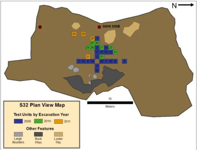
Sachsen Cave Shelter is a large, sandstone rock house type shelter, although it is technically a cave by the Tennessee Cave Survey standards as the dripline is more than 50 feet from the back wall (see Figure 1). Sachsen Cave Shelter is split into two separate chambers. The larger chamber is designated as S32 and the smaller chamber, S32 North. The shelter is located very near modern houses and roads, and has received a fair amount of attention from local relic hunters, although it has been protected from looting since the 1970s. Sachsen was noted for archaeological significance by University of Tennessee (UT) and East Tennessee State
University (ETSU) archaeologists in 2007. Surface collections at this time included Woodland ceramics, Archaic bifaces and animal bone. The upper portions of the site appeared to have been extensively looted, but it was hoped that excavations may reveal intact deposits. The shelter itself is quite extensive (Figure 2) with a width of about 20 meters and height of about 2-3 meters. The central back wall of the shelter is only about 15 meters from the drip line, but the north and south walls are located another 15-20 meters further, where ceiling height only permits crouching or crawling to reach the furthest corners of the shelter. Deposition was not observed in these areas.
The shelter is both wet and dry, depending on the time of year and weather conditions. When it is dry, areas where water has moved through the shelter can be observed (Figure 3). The site is located near a semi-permanent water source. Only a few feet below the northern most edge of the shelter is a small stream that runs for most of the year. This stream empties into the larger Mill Creek just upstream from where Mill Creek intersects with Lynn Branch. Mill Creek meanders eastward for several miles before joining with North White Oak Creek. The entire system eventually drains into the Big South Fork of the Cumberland River. Other small tributaries to the Cumberland River and Dale Hollow Lake are located to the west, south and
22
north of the shelter all at a distance of at least 16 kilometers or more; however there are many smaller creeks located nearby. There are also many more rock shelter sites nearby, including one directly below S32 and S32N where a large nutting stone was recorded, and still remains.
Excavations began at the site in the summer of 2008 as part of an ETSU archaeological field school directed by Jay Franklin. Three additional seasons of excavations have been carried out at the site, and a small connected site (Sachsen Cave Shelter, North) from 2009-2011. S32 North lacked stratified cultural deposits, and few artifacts and very few faunal remains were recovered from this context. This area of the site is therefore excluded from further discussions here. Presented in this chapter are the excavation methods, results and interpretations from three field seasons of excavations at Sachsen Cave Shelter.
Figure 1: Sachsen Cave Shelter - facing North, July 2012. (S32N is located just past the dog and two hemlock trees)
23
Figure 2: Central portion and excavations at Sachsen Cave Shelter. ETSU field school students, June 2008.
24
Figure 3: Evidence of water flow - looking south toward the back corner of the shelter – water flows North, July 2012.
25
2008 Summary of Excavations
A crew of ETSU field school students, including the author, began the first archaeological investigations at the shelter in early June of 2008. A datum was placed just inside the drip line near the center of the shelter (Figure 4), and a grid was established for the site. The first test units were then placed at 1 meter intervals along the North-South and East-West axes of the grid. Sediments from the upper levels of the first 9 test units were hand excavated in arbitrary 5cm levels and dry-screened through 2.5cm mesh. Test Unit 10 was designated as a sondage (a testing) unit and was excavated by shovel in the upper, disturbed levels until a thick, black stratum was encountered about 20cm below the surface. This stratum is interpreted as a midden deposit associated with the Late Archaic Period. Further excavations in this unit continued by hand, in 5cm levels. Two Late Archaic bifaces were recovered from the top levels of the stratum. As other test units were excavated, it was noted that the stratum seemed to be restricted to the central portion of the shelter. As the stratum was encountered in each test unit, combined 2.5cm and .32cm water screening were employed for 1/3 of the samples from every level within the stratum (every third 5 gallon bucket of sediment). Additionally, a 1 gallon flotation sample was taken from the Southwest corner of each test unit, once within the stratum (see Table 1 for recovery methods and estimated amount of excavated sediments for each provenience).Levels continued to be excavated in 5cm increments, except where stratigraphic changes were noted. Once encountered, the dark black stratum is about 30-40cm thick in all units until a sterile, Pleistocene deposit of weathered sandstone is encountered. This is the bottom of the shelter itself.
26
Figure 4: Site map, Sachsen Cave Shelter, showing all years of excavation. Map produced by Lucinda Langston.
27
A total of 19 1x1m test units was excavated during this first field season – all but two test units (TUs 17 and 18) reached the sterile Pleistocene layer. An estimated 9,635.4 liters of
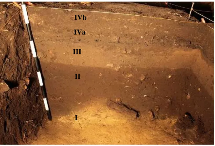
sediment were excavated from these 19 test units during this field season. The majority of the archaeological materials was located in the very central portion of the shelter. These deposits reached nearly one meter in depth near the dripline, but in most places were between 40 and 60cm deep/thick. Four stratigraphic layers were identified (see Figure5). Layer I is the
aforementioned Pleistocene deposit of weathered saprolite. Directly above this layer is Layer II, the thick black stratum, likely a midden associated with the Late Archaic Period. This layer is approximately 40cm thick in all of the excavation units located in the interior portion of the shelter, but becomes thinner toward the peripheries of the shelter (Test Unit 5 and 9 – deposits about 35cm below elevated datum). Layer III is a comparatively thin Woodland layer (about 10-15cm thick) that was present in some, but not all of the test units in the interior portion of the shelter. This layer truncated the Late Archaic deposit in some places, but was largely disturbed by looting activities itself. A small assemblage of Woodland ceramics was recovered from this layer, mostly cord-marked, limestone tempered sherds, a type that persists for the entire Woodland period on the Upper Cumberland Plateau (Franklin 2002). This layer is about 13-15 cm thick. Layer IV is split into two sections, a/b, for two different sediment colors, however, this entire layer is recognized as disturbed sediment.
28
Table 1: Proveniences sampled for 2.5cm and .32cm screening and flotation and estimated amount of total sediment excavated.
2.5cm dry/wetⱡ .32cm wet* Flotation*
Test Unit Level(s) Estimated Excavated Sediment (liters) Level(s) Estimated Excavated Sediment (liters) Level(s) Estimated Excavated Sediment (liters) Total excavated sediment (liters) 1 1-16 829 8-16 135 8-16 36 865 2 1-13 632 7-13 105 - 0 632 3 1-11 585 10-11 30 10-11 8 593 4 1-9 507 8 15 - 0 507 5 1-6 221.4 - 0 - 0 221.4 6 1-10 520 - 0 - 0 520 7 1-9 432 - 0 - 0 432 8 1-6 382 1, 2 30 - 0 382 9 1-7 364 - 0 - 0 364 10 1-8 630 3-4, 8 45 4-8 20 650 11 1-15 582 - 0 6-14 36 618 12 1-9 440 4-9 90 4-9 24 464 13 1-11 556 8-10 45 8-11 16 572 14 1-14 573 9-14 90 7†, 9-14 28 601 15 1-9 490 - 0 - 0 490 16 1-9 344 - 0 - 0 344 17 1-10 1362 5-7 45 3†, 7 8 1370 18 1-10 591 - 0 8† 4 595 19 1-3 170 - 0 - 0 170 20 1-15 606 - 0 12-13 20 626 21 1-17 703 - 0 6†, 9†-16 90 793 22 1-18 757 - 0 14-17 40 797 23 1-17 734 - 0 15 10 744 24 1-8 330 - 0 5-8 40 370 25 1-9 485 - 0 - 0 485 26 1-4 198 - 0 - 0 198 27 1-9 377 - 0 - 0 377 28 1-17 810 1-17 850 6-9 40 850 29 1-18 900 2-18 850 - 0 900 30 1-13 720 2-13 600 6-13 80 800 31 1-9 382 1-9 450 1-9 90 472 Total 17216.4 3395 586 17802.4 * TU 1-19 Flotation = 4L, .32cm =15L ; TU 20-31 Flotation = 10L,1 /8" = 50L
ⱡ 2.5cm and .32cm screens nested
† TU14 L7 flotation for hearth, TU17 L3 historic charcoal concentration, TU18 L8 under nutting stone, TU21 L6 feature, TU21 L9 feature
29
Artifacts from the Late Archaic layer include a large number of stemmed bifaces (Wade, Matanzas, Merom and other asymmetrical stemmed bifaces) and scrapers, modified bone points (likely awls), several in situ nutting stones, a few pieces of steatite vessel sherds and many botanical and faunal remains. The results of lithic, botanical and faunal analyses from a sample of this deposit are reported in Franklin, et al. (2010) along with four radiocarbon dates (which are presented in Table 2). The dates indicate that the Late Archaic layer was deposited over a 3,000 year time span from late Middle Archaic – Late Archaic Period. Lithic analyses conducted include organization of technology, use-wear and site-formation processes. Lithic debitage was analyzed by both flake portion approach (Sullivan and Rozen 1985) and debitage stage approach (Magne 1989). Both of these analyses seek to characterize reduction sequence. As discussed in the introduction, it is expected that all sequences of the lithic reduction sequence should occur at a base camp.
The results of these analyses indicate that the majority of chert used at the site is local, and all stages of the reduction sequence are represented on site for the Late Archaic component. Butchering, hide processing and woodworking activities are reflected in use-wear analyses conducted on 94 stemmed bifaces (31 displayed evidence of use-wear) (Franklin, et al. 2010:462). Furthermore, given the high number of tools and tool fragments (n=103) and low percentage of late stage tool debitage (37%), the Late Archaic component at Sachsen Cave Shelter is referred to as a “long term layer” (Franklin, et al. 2010; Magne 1989). This long term layer would have accumulated either during long stays, or repeated use over a long period of time or more likely, some combination of both.
30
Figure 5: S32 Stratigraphy – TU2 N Wall, photo courtesy Jay Franklin.
Layer I: sterile sandstone bedrock; Layer II: Late Archaic deposit (~6,800 cal. BP to 3,600 cal. BP); Layer III: Woodland deposit (~500-1000AD); Layer Iva/b: reworked sediments from
looting activities.
IVb
IVa
III
II
I
31
Table 2: AMS dates S32, adapted from Table 1 Franklin et al. 2010.
Sample no. Provenience 14C age assay (BP)
~ Mean Calibrated
age (BP)
Calibrated date range BC (2σ)
AA82906 TU2, L7, Layer
II, 30-35 cm bs 3385 ± 41 3638
1863-1851 (1.1%) 1772-1604 (88.0%)
1587-1534 (6.3%)
AA82908 TU2, Layer II,
45 cm bs 4379 ± 45 4951
3311-3296 (0.8%) 3285-3275 (0.5%) 3266-3239 (2.8%) 3106-2896 (91.2%)
AA83006 TU10, Layer II,
15 cm bs 3363 ± 37 3623
1744-1602 (81.8%) 1591-1532 (13.6%)
AA83007 TU10, Layer II,
32
Botanical remains represented at the site include burned wood, such as oak and pine and many carbonized nut remains such as hickory, walnut and acorn. The presence of these types of nuts species indicates fall occupation (Franklin, et al. 2010:472); however, it should be noted that nuts can be stored year round. No early cultigens have been identified in botanical analyses conducted thus far. A portion of the faunal assemblage was analyzed by Dr. Renee Walker at S.U.N.Y. Oneonta. Walker analyzed 737 faunal remains from a sample of Late Archaic levels from Test Units 2, 3,4, 5,7, 9,10, 11, 12, 13, 16 and 17 (Franklin, et al. 2010). A bone awl from disturbed context was also included in this analysis. The results of Walker’s analysis are
incorporated in the results presented in this thesis. Briefly, her results suggest that on site butchering of white-tailed deer took place, followed by transport of meaty portions to another location, as many of the bones from this sample are head and lower leg parts. By this measure, Sachsen could be interpreted as a hunting camp. It is hypothesized that with a larger sample of deer remains, this distribution may change. However, it could be that white-tailed deer lower legs were being exploited for particular purposes, such as retrieving sinew, marrow extraction or cannon bones were being used as blanks for bone point production. Preservation could also be a factor of less dense and spongy axial elements. These hypotheses will be further explored in Chapter 6 and elaborated in Chapter 7.
In sum, the 2008 excavations at Sachsen Cave Shelter revealed a large Late Archaic deposit, numerous Archaic and Woodland artifacts, dense faunal and botanical assemblages, several in situ nutting stones and several steatite stone bowl fragments (Franklin, et al. 2010). Artifacts other than faunal remains suggest that the site was used as a residential base camp by Late Archaic peoples of the UCP. Faunal remains indicate, however, use as more of a hunting camp, rather than residential base. The function of the site during the Woodland Period has not
33
yet been interpreted, largely due to poor delineations of this layer. A small artifact assemblage of Woodland artifacts indicates that the shelter was not used as intensively during the Woodland Period as the Late Archaic Period, but this could be the result of looting. No radiocarbon dates have been obtained for the Woodland layer thus far.
2010 Summary of Excavations
A second ETSU field school was conducted at Sachsen in June of 2010. The focus of this field season was to explore the Late Archaic deposit in the interior portions of the shelter left unexcavated during the previous field season. Eight additional test units (20-27) were excavated during the 2010 field season and two test units that were not completed previously (TU 17 and 18) were also finished. An estimated 5,145 liters of sediment were excavated from the shelter during this field season. Given that we knew where the Archaic deposit began, as in some cases the layer was clearly defined in exposed profile walls, our excavation strategies remained similar to the previous year of excavation, however, no .32cm water screening was conducted on site. Flotation samples were increased to 10L samples that were collected from the SW corner of each test unit once inside the Late Archaic layer. The lithics, ceramic and botanical remains recovered during this field season have yet to be analyzed and only a portion of the faunal remains were analyzed here. While this excavation season was targeted to further the exploration of the Late Archaic deposit, the lack of analyses conducted on material recovered during this season offer little more to the previous interpretations of the site. More nutting stones were, however,
recovered during this field season, indicating that nut processing may have been a more intensive enterprise at the shelter than originally interpreted.
34
2011 Summary of Excavations
The focus of the 2011 excavations were driven more toward specific research questions surrounding this thesis. Only four test units were excavated (28-31). Test Units 28 and 29 were initially designated as control units for faunal recovery and faunal preservation, while Test Unit 30 was excavated in the uninvestigated southwest portion of the site to explore the extent of deposits (see Figure4). All sediments from Test Unit 28 and 29 were water-screened through nested 2.5cm and .32cm mesh. Ten liter flotation samples were also taken from the Southwest corner of each 5cm arbitrary level. Furthermore, sediment samples for pH testing were taken in two places from each level of these two test units. Unfortunately, Test Units 28 and 29 were both heavily disturbed much like other test units located near the mouth of the shelter. When this became evident, recovery strategies were switched in Test Unit 30 (i.e., sediment samples, .32cm screening and flotation). Exposed profile walls of previous excavations were then reexamined, as we tried to sort out where the most undisturbed sections of the shelter may be located. Given that Sachsen is such a deep rock shelter, light is limited near the back of the shelter and all
excavations in the interior portion of the shelter had to be illuminated by standing lights and headlamps. It seems that relic hunters often lacked these supplies when exploring the site themselves, as the dark portions of the rock shelter were relatively unaffected by looting activities. After a long review of options, an 80cm x 1m square was outlined on the border of a long east profile wall from the 2008 excavations. The undisturbed Woodland level atop the dense Late Archaic layer was clearly visible in this profile wall, although about 20cm of the wall had collapsed or had been damaged since initial excavations. Water runs through the back portion of the cave (a topic that will be revisited later) and dogs and coyotes frequent the rock shelter today, all adding to the poor profile wall preservation with time. The walls were cut back and screened
35
separately. Each stratigraphic layer was excavated in 5cm levels until it was necessary to dig in natural levels when changes in sediment color were encountered. Excavated sediment from each level was screened through nested 2.5cm and .32cm mesh, and 10L flotation samples and 2 sediment samples for pH testing were taken from each level. Test Unit 31 thus represents the only test unit with an intact Woodland and Archaic level excavated with complete control of recovery and preservation bias. The 2.5cm recovered faunal materials, flotation samples, sediment samples and .32cm recovered material from Test Unit 30 and 31 were processed and analyzed by the author in the Fall of 2011 and presented at the 2012 Current Research in
Tennessee Archaeology meeting (Dennison 2012) as preliminary results to this thesis concerning sampling and preservation biases. All faunal data from both test units is presented in Chapter 6; however, only the pH values from Test Unit 31 are presented.
Lastly, a 1 x 3m trench was opened in front of the dripline on the north half of the shelter also during the 2011 field season. The trench was excavated to gain a better understanding of the site stratigraphy as viewed from outside the rock overhang. Few artifacts were recovered;
however several of these were faunal and are included in the results of this analysis.
Summary of Excavations
A total of 31 test units was excavated during three field seasons of work at Sachsen Cave Shelter. All but 2 (TUs 26 and 27) were excavated to the sterile yellow Pleistocene sand. To estimate the amount of sediment deposited, the distance in centimeters between top center elevation and bottom center elevation for each test unit is used as height in the volume ratio: v = length x width x height. In all cases but one, length and width are the same, 100 cm. This data is presented in Table 1, whichalso outlines the amount of sediment screened through 2.5cm, .32cm and .16cm mesh (note: .32cm mesh nested under 2.5cm mesh). In total, 17,802.4 liters of