Spatial Data Infrastructure for Pro-poor Land Management
Dev Raj PAUDYAL and Kevin MCDOUGALL, Australia
Key words: Land Administration, Pro-poor land management, Informal settlement, Spatial Data Infrastructure
SUMMARY
Various organisations are working to improve the living conditions of informal settlement and move them into the formal system. UN-HABITAT is one of the organisations working for the Habitat Agenda and has launched a pro-poor land management concept to improve the lives of slum dwellers through a flexible approach. City authorities generally consider slum or informal settlement as illegal. There is a general lack of reliable information necessary for planning and policy formulation required for upgrading and regularisation of these areas. Spatial data infrastructure (SDI) is critical to planning and decision making for pro-poor land management. However, the conventional spatial data infrastructure (SDI) concept is inadequate for informal settlement upgrading and regularisation. Therefore it is important to explore an appropriate SDI to accommodate new forms of legal evidence, utilisation of new technologies and open spatial information services.
TS 10B - Spatial Information Infrastructures to Address Social Aspects 2/14
Spatial Data Infrastructure for Pro-poor Land Management
Dev Raj PAUDYAL and Kevin MCDOUGALL, Australia
1. INTRODUCTION
Informal settlements are common features of urban growth in most developing countries (Zeilhofera and Topanotti, 2008) and are typically the product of an urgent need for shelter by the urban poor. Rapid urbanization, inefficient land administration and inadequate capability to cope with the housing needs of people in urban areas have contributed to the development of informal settlements(UNECE, 2009). According to Homeless International (2005), there are about 900 million people or 32% of the world’s urban population living in slums with 43% percent of slum population clustered in developing countries. This is projected to rise to 1.4 billion by 2020 (UN-HABITAT, 2006). World-wide, around 2.8 billion people currently live in cities. By 2007, more people will live in cities than in rural areas (McLaren et al., 2005). Most of the developing countries experience a massive migration from rural areas to cities where the majority of the new urban dwellers settle in non-regularised areas, often in locations that are exposed to natural hazards (such as land slides and flooding) and to ill health, illiteracy and unemployment. They thus remain in poverty. Lack of secure tenure discourages residents from improving conditions through investment in their houses and in common services such as water, sewerage, roads, etc. Land tenure in these types of settlement is informal, and does not provide adequate security for the residents. Since these settlements are not part of the formal land management system there is also a lack of reliable information necessary for planning and policy formulation for upgrading and regularisation of the areas (Nordin, 2004).
The issues related to informal settlement is of global concern, as clearly stated in the year 2000 United Nations Millennium Declaration. The Millennium Development Goal 7, Target 11, aims to significantly improve the lives of at least 100 million slum dwellers by the year 2020 (UN-HABITAT, 2003). The problem of informal settlements is a very serious issue for developing countries. As in other developing countries, the issue of slum dwellers is one of the main concerns for the Governments of Nepal and India. Lack of secure property rights in the occupied lands inhibits investments in housing, sustainable food production and access to credit. In Nepal, 30381 people were identified as landless family and 41035 were identified as informal settlements (Landlessness Solution High Level Commission, 2000). Whilst approximately, 61.8 million urban dwellers live without tenure rights in very poor condition on public land (COI, 2001).
forms of legal evidence for tenure security in cities for urban development as well as management. In addition to the cadastre, there are many forms of spatial information available which are useful for informal settlement regularisation and upgrading. However, many new forms of spatial information and technology are not recognised nor accepted by the municipal authorities. This paper explores the role of spatial data infrastructure to assist in pro-poor land management.
2. PRO-POOR LAND MANAGEMENT AND SPATIAL DATA INFRASTRUCTURE (SDI)
Land management is the process by which the resources of land are put into good effect (UN-ECE, 1996). Land management encompasses all activities associated with the management of land and natural resources that are required to achieve sustainable development. The concept of land includes properties and natural resources and thereby encompasses the total natural and build environment (Enemark, 2005). The concept of pro-poor land management originates from United Nations Human Settlements Program (UN-HABITAT). According to UN-HABITAT (2004) the pro-poor land management has the following characteristics:
– The development of an appropriate and flexible form of tenure
– A participatory planning approach for informal land delivery processes – Links to services to increase community capacity for sustainability
– A decentralised land administration system that uses local capital and is in partnership with local authorities
– Local land information systems that are transparent and close to civil society and the poor who require the information for decisions making regarding their land – A cost recovery approach or self reliance
Spatial data and infrastructure play an important role in land management. Spatial data infrastructure is a dynamic, hierarchical and multi-disciplinary concept that encompasses policies, organizational remits, data, technologies, standards, delivery mechanism and human resources dimensions. The spatial data infrastructure is being proposed as an enabling platform to improve, access, sharing and to integrate spatial data and services (Rajabifard, 2007). SDI can also viewed as a portal where each stakeholders can access, use, and exchange spatial data for social, economic and environmental well-being (Feeney et al., 2001, McDougall, 2006). However, the traditional approaches of SDI development rely largely on government agencies and formal land administration and management which do not adequately support to the informal arrangements of the poor with respect to land management. The advent of spatial technology and open models for spatial information services provide grass-root citizens and community groups the ability to participate and use spatial data for their own purposes. The application of open and user generated information may provide a new approach for pro-poor land management.
TS 10B - Spatial Information Infrastructures to Address Social Aspects 4/14
In Nepal, three types of land tenure primarily exist, being Raikar, Guthi and informal (Paudyal, 2006). The Raikar is state ownership and allows the land owners to use, inherit, sell and pay tax. Raikar land can further be classified into private lands, public lands and government lands. Trust institutions hold the ownership rights on Guthi lands, but the rights of use can be alienated to individuals under the conditions imposed by trust institutions. The informal land tenure system continues as the number of informal setters increases daily. In Kathmandu Valley alone, there are 64 settlements, 2844 households and 13243 landless people (sukumbashi) (Kantipur, 2008). Some informal settlers have prepared separate maps/plans showing the occupancy of these settlements. It is important for governments to recognise the non-formal land tenure and bring it into the formal land tenure framework. There is a need to formulate land policy and a legal framework that accords property rights to informal settlers and gives them a life of dignity.
[image:4.595.84.509.443.528.2]Many institutions are involved in land administration and management activities in Nepal (See Figure 1). The Survey Department is responsible for cadastral mapping and Department of Land Management is responsible for land registration. Both the departments maintain land records (cadastral maps and ownership records) at their district offices. Department of Land Information and Archive is responsible for building the land information system and technical support to land administration activities. Municipalities are responsible for land tax and protection of public land. Cadastral maps, field book, land ownership certificates, file maps, land subdivision register are the main components of Nepalese cadastre. Graphical cadastral maps are the basis for formal land administration activities. Deed registration system is used for land registration (Survey Department, 2003). The cadastral surveying of whole country has been completed and re-surveying of selected districts is on-going. Some of the informal settlements have surveyed and prepared maps via a community program.
Figure 1: Agencies involved for land administration in Nepal
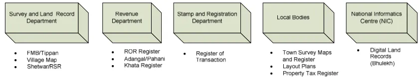
There are a number of governmental and non-governmental organizations that are directly or indirectly involved in land management. The institutional arrangement for land administration and management varies from state to state. However, the structure of land administration in any Indian state comprises of five main institutions (See Figure 2). The Land Revenue Department maintains the textual database for land records as well as tax registers. The Survey and Settlement Department is responsible for maintaining spatial data, mapping and demarcating boundaries, and executing surveys for sub-division on demand (Survey of India, 2003). In many states, it is now integrated with the Revenue Department. The Department of Stamps and Registration is responsible for registering deeds and for collecting the stamp duty due on these transactions. Local Authorities (Municipal corporations or panchayats) maintain property tax register and in some cases also maps, layout plans, or city surveys in areas that have not covered by original surveys (World Bank, 2007). National Informatics Centre (NIC) provides technical support in Geo-ICT sector and responsible to maintain digital land records (Bhulekh) portal. The scheme of computerisation of lands records (CLR) is a centrally sponsored scheme of the Government of India and was initiated in 1988-89.
Figure 2: Agencies involved for land administration in India
4. CASE STUDY AND DATA COLLECTION
The study area for this research covers two regions namely the Kathmandu Valley in Nepal and Allahabad City in India. A brief profile of both case study areas is described in the following section. Field studies consist of 10 informal settlements areas in Kathmandu Valley and 15 informal settlements areas in Allahabad. Interview and field observations were the methods for data collection.
4.1 Kathmandu Valley (Nepal)
Kathmandu Valley comprises of five municipalities (Kathmandu, Lalitpur, Bhaktapur, Kirtipur and Thimi) with a population of about 1.5 million people or around 220,000 households. One-third of its residents live in slum dwellings and 18,000 people are squatting in informal settlements (without land rights) (3CD, 2005). The Kathmandu Valley is the political, administrative and economic centre of Nepal and hence has become a favourite destination for migration of the rural population.
TS 10B - Spatial Information Infrastructures to Address Social Aspects 6/14
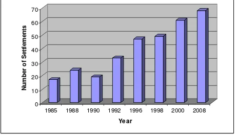
decades. In most cases, settlements occupy government and public lands, especially areas around the river banks. This places tremendous pressure on the limited infrastructure and causes environmental degradation as well as social and economic problems in this area. 0 10 20 30 40 50 60 70 N u m b e r o f S e tt le m e n ts
1985 1988 1990 1992 1996 1998 2000 2008
[image:6.595.183.414.129.262.2]Year
Figure 3: Informal Settlement Development
It was found from the field study in the Kathmandu Valley that the informal settlements have the following characteristics:
– Are multi-cultural communities;
– Involve of political groups who have vested interests;
– Poor economic conditions – can neither pay rent for proper housing nor can afford to buy a house;
– Inability on the part of the local administration to prevent encroachment of government-owned land;
– Migration from rural areas in search of livelihood as urban areas provide commercial and industrial set-up offering greater employment opportunities; and – Preference to occupy river banks and public land.
Many informal settlements have their local name and own administrative division. It is quite interesting that they have assumed their own separate administrative unit from the municipality including their own rules and regulations to govern the community. Often settlements do not getting sufficient water to fulfil their water demands and are without sewerage facilities which mean that people dispose of household waste water and solid wastes directly into open drains which adversely affects the physical environment. Many houses are made of bamboo and mud and the living space inside the house is generally insufficient for the number of occupants. The local communities sometimes run their own schools, public health centres and temples. NGOs and local community share the running costs and although they are of a low quality, the settlers are very happy to get these facilities in their locality. The settlers also manage funds for the maintenance of basic services.
settlements are unplanned and often not serviced and can be found on marginal or environmentally hazardous land.
The informal settlements in Nepal are relatively recent with most of the settlements in Kathmandu Valley formed within last two decades. The Nepalese government has adopted a national approach to address the challenges of informal settlements through the formation of a high-level commission. The major policy interventions include (a) legalisation; (b) regularisation and upgrading; and (c) resettlement and reallocation. For all three policy interventions, cadastral maps and land registry data are essential in supporting decision making. However, the lack of accurate and reliable spatial information has limited the effectiveness of these interventions.
The landlessness problems and informal settlement regularisation always gets high political priority by the ruling government in Nepal. However, the implementation side is often difficult and complex. One of the main limitations faced by the government is the availability, reliability and accessibility of land information. From the case study, we found that most of the settlers have occupied vacant public land/government land. On the cadastral maps, the areas are shown as a governmental or public land e.g. river, road, recreational area etc. However, in field, there is a large informal settlement which has not been recorded on the government documents.
4.2 Allahabad City (India)
Allahabad city is an important centre of education and business, and one of the least industrialized and least polluted cities in east Uttar Pradesh (UP), India. It is located in alluvial plains of the Rivers Ganga and Yamuna. According to the categorisation by the Census of India (CoI), the city of Allahabad is composed of three regions namely the Municipal Corporation of Allahabad (MCA), the city outer growth (OT) and the Allahabad Cantonment (CB). The municipal area of the city covers approximately 82 km2 areas and has a population of around 975,000 people (AMC, 2006). The urban poor population in Allahabad is almost 1/3 of the total population and the rapid growth of informal settlements has contributed to social and environmental problems in the urban area.
A large number of informal settlements are clustered along riverbeds, in the core of the old city, in the cantonment area and other environmentally sensitive areas. A survey carried out by Oxfam (India) Trust in 2005 suggested that there were around 283 informal settlements in Allahabad with a population of approximately 363,000 people. This constitutes 30% of the total population of the city. However, as per the governmental record (COI, 2001), only about 15% of city’s population lives as informal settlers.
TS 10B - Spatial Information Infrastructures to Address Social Aspects 8/14
It was found from the field study that the Allahabad city informal settlements have the following characteristics:
– Desire of people to live close to one's own community;
– Involvement of religious or political groups who have vested interests;
– Poor economic conditions – can neither pay rent for proper housing nor can afford to buy a house;
– Inability on the part of the local administration to prevent encroachment of government-owned land;
– Migration from rural areas in search of livelihood as urban areas provide commercial and industrial set-up offering greater employment opportunities; and – Occupy environmentally hazard areas.
In Allahabad city, only about 25-30% of informal settlements (authorised or unauthorised) have individual water supply connections and other 70-75% of people are dependent either on the public stand post and hand pumps or do not have access to the potable water or municipal water. Mostly, the settlements are without sewerage which adversely affects the physical environment. The informal settlements in Allahabad city are old and well accepted by the local community.
A three tier government structure exists in India with the central government responsible for overall policy formulation. Land matters are the responsibility of the state government whilst local government is responsible for the implementation of land policies (Banerjee, 2002). The Slum Urban Development Authority (SUDA) is responsible for the overall development of the informal settlements through of Community Development Centres (CDC). The District Urban Development Authority (DUDA) is responsible for implementing plans prepared by SUDA and field works relating to informal settlement development.
The four major types of policy interventions for informal settlement development in Allahabad city include (a) legalisation; (b) regularisation and upgrading; (c) the development of alternative housing systems; and (d) resettlement and reallocation. For all four policy interventions, cadastral maps and land registry data are commonly required. Jawaharlal Nehru National Urban Renewal Mission (JNNURM) is a national programme which focuses on providing basic services and other civic amenities for the urban poor through integrated settlement development. This national programme has the goal of introducing e-governance services in Urban Local Bodies (ULBs) using information technology applications like GIS, MIS etc. for various services provided by ULBs. However, the spatial coverage, completeness, accuracy, quality and reliability of spatial information are lacking.
5. THE ROLE OF SPATIAL DATA INFRASTRUCTURE FOR PRO-POOR LAND MANAGEMENT
In Nepal, the digital cadastral data forms the basis for development of a land information system and local spatial data infrastructure. In Kathmandu Valley, the cadastral maps are geo-referenced with national geodetic framework. The Nepalese Government has initiated the computerisation of land records since 1993. In 2000, the Council of Ministers decided to establish a new department called the Department of Land Information and Archiving (DoLIA). The district wise development of land information system has begun. In resurveying, the informal settlement areas are mapped as a block parcel. Within that block some community members have prepared separate maps showing the occupancy of informal settlers though these maps remain in the informal domain. This information could be utilised to build a SDI for pro-poor management.
In 2008, Government of India initiated the National Land Records Modernization Programme (NLRMP) to build spatial data infrastructure based on satellite imagery/aerial photography, Survey of India/ Forest Survey of India maps, and revenue records (cadastral maps and right of records). It aims to prepare digital cadastral database of whole country and improve the connectivity amongst the land records and registration offices and land records management centres. The awareness for the building spatial data infrastructure for land management has been initiated but its development is the responsibility of state government and not the local municipalities (Department of Land Resources, 2008). In Allahabad, the computerisation of land records has been initiated by NIC-Allahabad. Although, the attribute information about the use, value and ownership of land parcel has been stored in a digital database, the cadastral maps are in analogue format and have not yet been connected to the national geodetic reference system.
In both of these countries, there is both top-down as well a bottom-up approach for building spatial data infrastructure. Government of Nepal has initiated the National Geographical Information Infrastructure programme (NGIIP) for building NSDI since 2002 and Government of India has initiated building NSDI since 2001. In both of the countries, the NSDI portal is operational and with the recognition that spatial information is a national resource and citizens, society, private enterprise and government have a right to access it, appropriately.
5.2 Building SDI for Pro-Poor Land Management
Based on the case studies examined, it is evident that the existing concept of SDI does easily address pro-poor land management. Conventional cadastral and spatial information approaches also provide limited support for informal settlement regulation. The traditional data custodianship and institutional arrangement are not relevant in this case as the existence of rights and responsibilities do not exist. However, there are possibilities for of achieving improvements in providing good spatial information in the public domain.
TS 10B - Spatial Information Infrastructures to Address Social Aspects 10/14
spatial information. Through open portals such as Google Earth, OpenStreetMap (www.openstreetmap.org) and Wikimapia (www.wikimapia.org) there is the opportunity for NGOs and the informal settlers to become the custodians of the spatial data. If governments are not prepared to recognise the tenure of these informal settlements then it will be the residents that may look to control their destiny. Therefore, an appropriate SDI should be explored which may accommodate both conventional as well unconventional approaches.
For pro-poor land management, an appropriate SDI might have the following characteristics
– Be an open and inclusive model incorporating both formal as well as informal land management tools;
– Be affordable by grass-root citizens and low maintenance and access costs; – Be transparent and user friendly;
– Supply evidence of informal rights such as (occupation rights, adverse possession, tenancy, use rights, customary rights and indigenous rights) which is supported by an appropriate regulatory framework;
– Integrate the information systems of a number of very diverse institutions; – Accommodate a range of identifier and spatial units;
– Deal with the upgrading, and incorporation of diverse information system over time; and
– Use local knowledge and resources.
The main motivation for developing a new SDI model is to improve the access, use and sharing of spatial information for the purpose of improving land management and decision making. In the case of pro-poor land management either there is no information or it is non-formal. In the absence of good spatial information regarding informal settlements the challenges of managing and resolving the economic, social and environmental problems that go hand in hand with these settlements cannot begin. Although the formalisation and regularisation of settlements may not be a solution for all situations, it does provide a mechanism for building community support and advancing the rights of the very poor.
In the case of developing countries, it is recognised that local government are often the first point of contact in management the informal settlements. Many of these local governments are poorly funded and lack the resources to effectively undertake mapping and land administration tasks. An informal open source SDI which can be contributed to by both individuals and local governments may provide a platform which can facilitate improved planning and decision making at the local level. This approach however also introduces a number of issues which relate to the accuracy, format of data, custodianship, liability and reliability. However, if managed in conjunction with local government and the community, this informal SDI may provide the basis for a gradual transition to more formal land administration and management for the poor.
6. CONCLUSION
Pro-poor land management is promoted by UN-HABITAT. A reliable and inclusive information infrastructure which includes pro-poor policy is necessary to recognise and support informal rights such as occupancy, adverse possession, tenancy, use rights, customary rights and indigenous rights tenure for pro-poor land management. The case study results have shown that conventional cadastral based information system design approaches and government managed institutional arrangements do not appropriately address land management issues in informal settlements. Various spatial identifiers are already utilised and there is significant potential to use open spatial data portal for planning as well as decision making in informal settlements.
In the case of developing countries, local government are often the first point of contact in management the informal settlements. It has been argued that an alternative SDI model which more flexible and bridges the formal and informal land management system is required for improved pro-poor outcomes. An informal open source SDI which can be contributed to by both individuals and local governments may provide a platform which can facilitate improved planning and decision making at the local level. This approach however also introduces a number of limitations. However, if managed in conjunction with local government and the community, this informal SDI may provide the basis for a gradual transition to more formal land administration and management for the poor.
ACKNOWLEDGEMENTS
The paper is the outcome of the research project " Low cost pro-poor land management techniques in developing countries: A case study in Nepal and India” supported under FIG Foundation Grant, 2007. The authors wish to gratefully acknowledge the FIG foundation for providing fund to carry out this research works.
REFERENCES
TS 10B - Spatial Information Infrastructures to Address Social Aspects 12/14
AMC (2006) City Development Plan for Allahabad. Final Report. Allahabad Municipal Corporation.
BANERJEE, B. (Ed.) (2002) Security of tenure in Indian cities, London, Earthscan Publications Ltd.
COI (2001) Census of India Report.
DEPARTMENT OF LAND RESOURCES (2008) National Land Records Modernization Programme(NLRMP). Department of Land Resources , Ministry of Rural
Development, Government of India.
ENEMARK, S. (2005) The Land Management Paradigm for Institutional Development.
Expert Group Meeting on Incorporating Sustainable Development Objectives into ICT- Enabled Land Administration Systems. University of Melbourne, Australia. FEENEY, M.-E. F., RAJABIFARD, A. & WILLIAMSON, I. P. (2001) Spatial Data
Infrastructure Frameworks to Support Decision - Making for Sustainable
Development. 5th Global Spatial Data Infrastructure Conference. Cartagena de Indias, Columbia.
FOURIE, C. (2001) The Use of New Forms of Spatial Information, Not the Cadastre, To Provide Tenure Security in Informal Settlements. FIG/UNCHS International Conference on Spatial Information for Sustainable Development. Nairobi, Kenya. FOURIE, C., MOLEN, P. V. D. & GROOT, R. (2002) Land management, land administration
and geo-spatial data: Exploring the conceptual linkages in the developing world
GEOMATICA, 56, 351-361.
HOMELESS INTERNATIONAL (2005) Isuue briefing on urbanisation and urban poverty in Asia.
KANTIPUR (2008) Report about the informal settlement in Kathmandu Valley. Kantipur.
Kathmandu, Nepal.
LANDLESSNESS SOLUTION HIGH LEVEL COMMISSION (2000) Progress Report. Landlessness Solution High Level Comission, Nepal.
MCDOUGALL, K. (2006) A Local-State Government Spatial Data Sharing Partnership Model to Facilitate SDI Development. Department of Geomatics, Faculty of Engineering. Melbourne, The University of Melbourne.
MCLAREN, R., COLEMAN, D. & MAYUNGA, S. (2005) Sustainable Management of Mega Growth in Megacities. FIG Working Week 2005 and GSDI-8. Cairo, Egypt. MOLEN, P. V. D. (2005) Unconventional Approaches to Land Administration
UN/FIG Expert Group Meeting Bangkok, Thailand.
NORDIN, B. (2004) The Development of a GIS for an Informal Settlement. UN-Gigiri
Nairobi, Kenya.
PAUDYAL, D. R. (2006) Pro-poor Land Management System: A Study Considering Dynamic Aspect of Land Tenure in Nepal. XXIII FIG Congress. Munich, Germany RAJABIFARD, A. (Ed.) (2007) SDI Design to Facilitate Spatially Enabled Society,
Melbourne, The University of Melbourne, Australia.
SURVEY DEPARTMENT (2003) Cadastral Template. Survey Department, Nepal. SURVEY OF INDIA (2003) Cadastral Template. Survey of India, India.
UN-ECE (Ed.) (1996) Land Administration Guidelines, Geneva.
UN-HABITAT (2004) Pro Poor Land Management Integrating slums into city planning approaches. Nairobi, Kenya, United Nations Human Settlements Programme.
UN-HABITAT (2006) State of the World's Cities 2006/2007: 30 Years of Shaping the Habitat Agenda. United Nations Human Settlements Programme (UN-HABITAT).
UNECE (2009) Self-made Cities. United Nations Economic Commission for Europe, ECE/HBP/155,United Nations Publications.
WORLD BANK (2007) India Land Policies for Growth and Poverty Reduction. Agriculture and Rural Development Sector Unit, India Country Management Unit, South Asia Region.
TS 10B - Spatial Information Infrastructures to Address Social Aspects 14/14 BIOGRAPHICAL NOTES
Dev Raj Paudyal is a PhD candidate in University of Southern Queensland, Australia. He has a M. Sc. Degree in Geoinformation Management (GIM2) from ITC, the Netherlands. He has more than 12 years of professional experience in Survey Department of Nepal. Before joining PhD, he was working as a head of Digital Cadastre Section, Cadastral Survey Branch. He was also working as a Part-Time Faculty Member of SchEMS, Pokhara University and involving for teaching as well as research works. He has approximately 25 publications in GI domain. His research interests include land administration, SDI, VGI and catchment management.
Kevin McDougall is Head of Surveying & Spatial Science in Faculty of Engineering and Surveying, University of Southern Queensland, Australia. Kevin has a Doctor of Philosophy from University of Melbourne and more than 25 years of professional experiences and approximately 100 scientific publications. Kevin has worked in a number of developing countries including the Philippines, Indonesia, South Pacific Island and Palestine on land administration and management. Kevin’s research interests include are land administration, SDI, VGI and spatial data sharing.
CONTACTS
Mr. Dev Raj Paudyal
Faculty of Engineering and Surveying University of Southern Queensland
West Street, Toowoomba, Queensland 4350 Australia AUSTRALIA
Tel. +61 7 4631-2633 Fax + 617 4631 2526 Email:[email protected] Web site: www.usq.edu.au
Associate Professor Kevin McDougall Head, Surveying and Spatial Science Faculty of Engineering and Surveying University of Southern Queensland
West Street, Toowoomba, Queensland 4350 Australia AUSTRALIA
Tel. +617 4631 2545 Fax + 617 4631 2526