TRANsREGioNAl liNkAGEs iN ThE
NoRTh-EAsTERN ATlANTic — AN ‘END-To-END’
ANAlysis oF pElAGic EcosysTEMs
clivE Fox1, RoGER hARRis2, svEiN suNDby11, ERic AchTERbERG4, J. icARus AllEN2, JohN AllEN4, AlEx bAkER5, coRiNA p.D. bRussAARD6, pAul bucklEy7, ElizAbETh J. cook1, sTEphEN R. DyE7, MARTiN EDwARDs8,
liAM FERNAND7,pETER kERshAw7, JuliAN METcAlFE7, svEiN ØsTERhus3, TED poTTER7, EGil sAkshAuG9, DouGlAs spEiRs10, ERliNG sTENEvik11,
MikE sT. JohN12, FREDE ThiNGsTAD13 & bEN wilsoN1 1Scottish Association for Marine Science, Dunstaffnage Marine Laboratory,
Oban, PA37 1QA, UK
2Plymouth Marine Laboratory, Prospect Place, Plymouth, PL1 3DH, UK 3Bjerknes Centre for Climate Research, Allegata 55, N-5007 Bergen, Norway
4National Oceanography Centre, University of Southampton, Waterfront Campus, Southampton, SO14 3ZH, UK
5School of Environmental Sciences, University of East Anglia, Norwich, NR4 7TJ, UK 6NIOZ–Royal Netherlands Institute for Sea Research, P.O. Box 59,
1790 AB Den Burg, Texel, The Netherlands 7CEFAS, Pakefield Road, Lowestoft, NR33 0HT, UK 8SAHFOS, The Laboratory, Citadel Hill, Plymouth, PL1 2PB, UK 9Norwegian University of Science and Technology, Hogskoleringen 1,
Gloshaugen, 7491 Trondheim, Norway
10University of Strathclyde, Livingstone Tower, Richmond Street, Glasgow, G1 1XH, UK 11Institute of Marine Research, Nordnesgate 50, P.O. Box 1870 Nordnes, 5817 Bergen, Norway
12Hamburg University, Institute for Hydrobiology and Fisheries Science, Olbersweg 24, 22767 Hamburg, Germany
13University of Bergen, Jahnebakken 5, P.O. Box 7800, N-5020 Bergen, Norway E-mail: [email protected]
considered and finally possible changes in the regional linkages over the next century are discussed. because of the scale of potential impacts of climate change, this issue is considered in a separate section. The review demonstrates that the functioning of the ecosystems in each of the regions cannot be considered in isolation and the role of the atmosphere and ocean currents in linking the North Atlantic ocean, North Atlantic shelf seas and the Arctic and Nordic seas must be taken into account. studying the North Atlantic and associated shelf seas as an integrated ‘basin-scale’ system will be a key challenge for the early twenty-first century. This requires a multinational approach that should lead to improved ecosystem-based approaches to conservation of natural resources, the maintenance of biodiversity, and a better understanding of the key role of the north-eastern Atlantic in the global carbon cycle.
Introduction
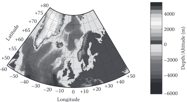
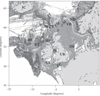
The European Network of Excellence for ocean Ecosystems Analysis (EuR-ocEANs) was estab-lished in 2004 under the European Framework vi funding programme to promote the integration of marine ecological research within Europe. The network includes around 140 researchers based in 69 research institutes from 26 countries and deals with research on pelagic ecosystems. when the network was founded in 2004, seven ‘systems’ were defined to give geographical scope to the proj-ect. These were the Arctic and Nordic seas, baltic, Mediterranean, North Atlantic ocean, North Atlantic shelf seas, southern ocean and upwelling regions. since many aspects of marine ecosys-tem functioning are related to latitude, bathymetry, and distinct climate regions, these ecosysecosys-tems do display some internally coherent features (e.g., productivity in the Arctic seas is typified by strong seasonality). however, marine ecosystems do not exist in isolation and this is particularly true for those systems with relatively open boundaries. The Arctic and Nordic seas, North Atlantic shelf seas and North Atlantic share common boundaries and the processes occurring across their boundaries act to modify local processes in important ways. This review examines these inter-linkages and gives a regional perspective to marine ecosystem functioning in the north-eastern Atlantic (Figure 1). because of EuR-ocEANs’ focus on pelagic systems, the review does not deal
–60 –50
–40 –30
–20 –10 0 +10 +20 +30
+40+50 +50
+55 +60
+65 +70
+75 +80
Longitude
Latitude
4000
2000
0
–2000
–4000
–6000
D
ep
th
/A
lti
tu
de
(m
)
[image:2.504.98.416.454.627.2]extensively with benthic ecology although the importance of benthic-pelagic coupling in nutrient recycling and the carbon cycle is acknowledged.
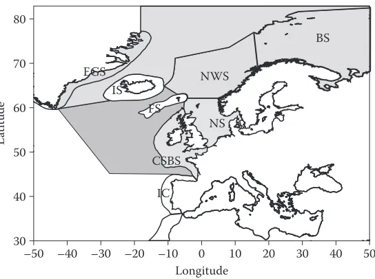
The system concept used in EuR-ocEANs is similar to the large Marine Ecosystems (lME) introduced by sherman et al. (1993). The aim of lME was to define sea areas on the basis of dis-tinct bathymetry, hydrography, productivity and trophic interactions to promote coherent analyses of their functioning and health (Figure 2). The lME defined by sherman did not extend into the deep oceans. however, as shown in this review, the linkages between the deep oceans and the lME cannot be ignored. since then, reviews of ecosystem functioning in several defined areas within the north-eastern Atlantic have been undertaken (e.g., for the Nordic seas; skjoldal 2004) and the Regional Quality status Reports produced under the auspices of ospAR. however, all these approaches suffer from the delineation of somewhat artificial boundaries. Although some geographic features, such as the shelf break, do define genuine transition zones between areas where different physical and biologi-cal processes dominate (e.g., tidal mixing is dominant on the shelf seas but less important in the open Atlantic), other boundaries are more arbitrary and have been drawn in relation to national or manage-ment considerations. The aim of the present review is to consider the interlinkages in the north-eastern Atlantic, that is between the Arctic and Nordic seas, European shelf seas and Atlantic ocean.
This review is also structured using EuR-ocEANs’ concept of ‘end-to-end’ analyses, which starts with a consideration of the physics and works up the food web to top predators such as marine mammals. For brevity, the review is also largely constrained to looking at those mechanisms ‘linking’ EuR-ocEANs’ regions and not the internal processes occurring within them. ocean currents, particularly downstream branches of the North Atlantic current, form the main physical link between the systems. heat, dissolved nutrients and particulates are all transported by these currents. This has significant impacts within the regions themselves (e.g., the transport of heat by the North Atlantic current (NAc) is the reason why ice cover is more limited in the Nordic seas compared to other areas at the same latitude). For pelagic biota, life-cycle duration tends to increase moving from lower to higher trophic levels. For example, individual phytoplankton cells, once in
NWS
BS
NS
–50 –40 –30 –20 –10 0 10 20 30 40 50
Longitude 30
40 50 60 70 80
La
titude
FS IS EGS
IC CSBS
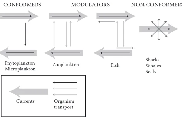
[image:3.504.118.390.64.267.2]a productive phase, can complete growth and division in a few days whilst many zooplankton take months to complete their life cycles. consequently, longer-lived planktonic organisms can be dis-persed over much larger distances compared with shorter-lived species. Although larger organisms such as fish are less directly affected by ocean currents, many have a planktonic larval phase. These can often exploit vertical differences in currents to influence their dispersal (Figure 3). in contrast, marine mammals can overcome flow velocities at all their life stages. Their life strategies and behaviour are therefore linked to the distribution patterns of their prey and predators. Moving from end-to-end we see that there is a transition from direct effects of oceanography on the dispersal of organisms to indirect effects via predator and prey distributions.
As well as direct oceanographic linkages between the regions, human activities are also increasing the exchange of materials between the regions. The most obvious example is the intro-duction of alien species (‘alien species’ refers to a species, subspecies or lower taxon introduced outside its natural past or present distribution whilst ‘invasive alien species’ means an alien spe-cies whose introduction or spread threaten biological diversity (convention on biological Diversity cop6 Decision vi/23), either via ships’ ballast water, hull fouling or through aquaculture. because of the regional connections many pollutants, introduced into one region, will spread through the north-eastern Atlantic. Finally, through industrial activities, humans are altering the concentrations of ‘greenhouse’ gases in the atmosphere and it is now almost certain that this is causing changes in climate that will persist over the rest of this century and beyond. in addition to affecting local temperatures, winds and precipitation/evaporation, this will lead to changes in some ocean cur-rents, again affecting the whole north-eastern Atlantic. As our understanding of marine ecosystems improves we are beginning to appreciate how local-scale ecology is linked to the complete range of spatial and temporal scales ranging from regional to global, short term to long term and from the underlying physics to top predators. Appreciation of these interconnections by wider society is vital if we are to manage our activities in ways that promote the sustainable use and development of European marine resources.
CONFORMERS MODULATORS NON-CONFORMERS
Phytoplankton
Microplankton Zooplankton Fish
Sharks Whales Seals
Currents Organism
transport
[image:4.504.104.401.65.257.2]Overview of the regions
The Nordic and Arctic Seas: general geography, size, bathymetry
The ‘Nordic seas’ is used as a common name for the waters to the north of the Greenland-scotland Ridge and between Greenland, Norway and spitsbergen. This region forms the main connection between the North Atlantic and the Arctic oceans. This area also includes wide shelf areas border-ing the Arctic land masses. The international hydrographic bureau defines the Norwegian sea as bounded to the east by the coast of Norway, on the north-east a line from North cape over bear island to the south-west point of spitsbergen (one of the svalbard islands). The western limit extends from this point along a line to Jan Mayen and further to the eastern tip of iceland. The southern limit extends from there to the Faroe islands and follows the 61st parallel to the coast of Norway. More recently, the oil industry has found it more practical to apply the 62°N parallel as the southern bor-der of the Norwegian sea. From an oceanographic point of view, it would be more correct to place the border to the north-east coincident with the shelf edge. The barents sea itself extends eastwards to Novaya zemlya and northwards to the shelf edge between Franz Josef land and spitsbergen.
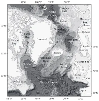
The main bathymetric features of the Nordic seas are depicted in Figure 4. The Fram strait, with a sill depth of about 2500 m, forms the main connection with the Arctic ocean. To the south,
NP UK Rockall plateau Hudson Bay Baffin Bay Irminger Basin Labrador Sea Arctic Ocean 140°W 70°N 60°N 50°N 40°N 60°N 50°N
160°W 90°W 70°W
40°W 50°W
60°W 30°W 20°W 10°W
Greenland
Newfoundland North Atlantic
Spain Bay of Biscay France Celtic Sea North Sea Iceland Mid-ocea n ridge Rock all troug h Dav
is Strait
Denmark Strait Norwegian Sea Faroes Norway Sweden Finland Greenland Sea Russia Fram Strait Barents Sea Svalbard Franz Josef Land
[image:5.504.87.418.288.624.2]the Greenland-scotland Ridge, with the deepest sills located in the Faroe bank channel (~850 m) and in the Denmark strait (~620 m), forms the border towards the North Atlantic. Topographic features within the Nordic seas divide the area into the Greenland, iceland and Norwegian seas. The most prominent of these features is the midocean ridge. Three main parts of this ridge system can be identified as the kolbeinsey Ridge, Mohns Ridge and the knipovich Ridge. The kolbeinsey Ridge extends northwards from the North icelandic shelf to the latitude of Jan Mayen where the Jan Mayen Fracture zone cuts through it. Generally this ridge ranges in depth between roughly 400 and 1500 m, but to the west of Jan Mayen, some seamount-like features are shallower than 300 m, the shallowest only 25 m deep. The Mohns Ridge, between Jan Mayen and approximately 73.5°N, 8°E, has depths ranging between 1000 and 2000 m. its rather complex topography is characterised by many isolated elevations. The shallowest peaks, the Myrseth and boyd banks, are both about 600 m deep. The knipovich Ridge stretches from Mohns Ridge to the Fram strait, its shallower crests being at about 1000 m depth. Along the centre of both these ridges there is a rift valley with depths mainly greater than 3000 m. The topography along the southern side of the Jan Mayen Fracture zone, between about 68°N, to the west of the vøring plateau, and 72°N off the East Greenland coast form a less-well-defined ridge system. Farther to the west, the area between Jan Mayen and Greenland is mostly shallower than 1500 m. between 66.5°N and 68°N off the Norwegian shelf the vøring plateau has depths mainly between 1200 and 1400 m.
These bathymetric features divide the Nordic seas into four major basins. To the west of the midocean ridge lie two deep basins in the Greenland sea. The Greenland basin is the largest of these, reaching depths from 3400 to 3600 m. To the north, the Greenland Fracture zone separates it from the smaller and shallower boreas basin. Along its margins there are several shallower struc-tures and seamounts, for example the vesteris bank (73°N, 9°w), which rises from the basin floor at approximately 3000 m to a depth of 130 m. Two deep basins are found in the Norwegian sea, the Norwegian and lofoten basins, the former being the largest and deepest basin in the Nordic seas. its floor lies mainly between 3200 and 3600 m, but depths exceed 3800 m in a narrow trough around 65°N, 5°w. The shallower and somewhat smaller lofoten basin to the north of the Norwegian basin reaches about 3200 m. The iceland plateau is the area between iceland and Jan Mayen to the east of the kolbeinsey Ridge. Along its eastern margin, which slopes into the Norwegian basin, the Jan Mayen Ridge extends southwards from Jan Mayen. west of this ridge lies a small basin that is more than 2200 m deep but elsewhere, depths are mainly in the range 1200 to 2000 m. west of the kolbeinsey Ridge the narrow scoresby and blosseville basins (to the south) extend from the Jan Mayen Fracture zone towards the Denmark strait.
The Nordic seas have been the subject of numerous national and international research pro-grammes. Although many originated with a fisheries focus, they have now broadened to include studies on most aspects of the ecosystem (skjoldal 2004). since the Nordic seas are experiencing particularly rapid changes linked with global climate, there has been a renewed emphasis on how these changes may affect biological productivity in the coming decades (Arctic climate impact Assessment [AciA] 2004). There has also been a strong emphasis on the development of interna-tional programmes to measure the strength of ocean fluxes in the region because of their fundamen-tal importance in climate control (Dickson et al. 2008).
The Atlantic: general geography, size, bathymetry
on the west by North and south America whilst in the north and north-east, it is separated from the Arctic ocean by the canadian Arctic Archipelago, Greenland, iceland, Jan Mayen, svalbard, and mainland Europe. it connects to the Nordic seas and Arctic ocean through the Denmark strait, Greenland sea, Norwegian sea and barents sea. To the east, the boundaries of the ocean proper are Europe and the straits of Gibraltar (where it connects with the Mediterranean sea). The average depth of the Atlantic is 3926 m but it reaches 8605 m in the puerto Rico Trench. The principle bathy-metric feature is a submarine mountain range, the Mid-Atlantic Ridge, which extends from iceland in the north to around 58°s. The ridge has a maximum width of about 1600 km and a great rift valley extends along most of its length. The depth of water over the ridge is generally less than 2700 m.
The North Atlantic has been the subject of a number of major coordinated programmes at both the international (Joint Global oceans Flux study, world ocean circulation Experiment, Global ocean Ecosystem Dynamics) and the European (Trans-Atlantic study on Calanus) levels. current relevant international programmes include the international council for the Exploration of the sea (icEs)/Global ocean Ecosystem Dynamics (GlobEc) cod and climate change (ccc) programme, which is a North Atlantic regional component of GlobEc. GlobEc is a part of the international Geosphere biosphere program (iGbp) suite intended to evaluate the causes and consequences of global change. Another relevant iGbp programme is iMbER (integrated Marine biogeochemistry and Ecosystem Research), which is currently under development. other inter-national projects such as climate variability and predictability (clivAR) and the Global ocean observing system (Goos) are also relevant.
The European shelf seas: general geography, size, bathymetry
The European shelf seas within the EuR-ocEANs’ context comprise the North sea and the celtic sea/biscay shelf lMEs (Figure 2). The North sea (including its estuaries and fjords) has a surface area of about 750,000 km2 and a volume of about 94,000 km3. it is relatively shallow in the south (including the southern bight and the German bight) but becomes progressively deeper moving into the northern North sea and the Norwegian Trench (Figure 5). The shallow kattegat forms a transi-tion zone between the North sea and the baltic. in the south, the North sea is subject to strong tidal mixing, which prevents thermal stratification. however, significant freshwater run-off generates a series of salinity fronts and transient haloclines in this region. water column structure in the central and northern North sea is strongly affected not only by localised heating but also by significant inflows of Atlantic water, mainly through the Faroe-shetland channel and by outflow of freshwater through the Jutland current, the kattegat and the Norwegian coastal current. The English channel is relatively shallow, and from a depth of about 30 m in the strait of Dover deepens gradually to about 100 m in the west. The seabed topography shows extensive evidence of river valley systems that were carved during glacial periods when the sea level was lower (ospAR 2000).
The celtic sea/biscay shelf lME covers 760,000 km2. in the north it consists of the waters to the west of scotland, including the Minch, between scotland and the hebridean islands. At this point the Rockall Trough separates the Rockall bank from the western scotland shelf with three significant seamounts, the hebridean, Anton Dhorn and Rosemary seamounts. The Rockall Trough follows northwards over the wyville-Thompson Ridge into the Faroe-shetland channel and this topography is an important feature for interconnections between the Atlantic and North sea (baxter et al. 2008). Moving south, the shelf broadens forming the Malin shelf and then follows the west coast of ireland. The irish sea itself is semi-enclosed and relatively shallow (<60 m) in the east but with a deep channel (down to 200 m) in the west. The shelf continues as the celtic sea and narrows adjacent to the French coast forming one side of the bay of biscay.
fish stocks (e.g., herring and mackerel) whilst efforts are being made to rebuild other historically important stocks, such as cod (horwood et al. 2006). Although the biological components of the shelf seas and the general physical conditions are fairly well described, the mechanisms respon-sible for interannual and longer-term variability in biological production are still poorly understood, and capturing the relative impacts of local and transregional processes is proving challenging. Nevertheless, understanding these couplings is crucial for sustainable resource exploitation in the North Atlantic shelf seas.
over recent decades there have been many national research programmes in these shelf seas (e.g., the uk Natural Environment Research council [NERc] North sea programme and German GlobEc). These have provided rich datasets for process understanding and for model develop-ment and testing. since the 1960s, annual fisheries resource surveys have been coordinated through icEs and these provide some of the best multinational long-term datasets for evaluating the effects of environmental change and exploitation. The region is also generally well covered by continuous plankton Recorder (cpR) routes (www.sahfos.ac.uk), which extend over the last 70 years. however, in the context of understanding the impacts of long-term environmental change on the complete regional ecosystem, data availability and consistency over time remain problematic.
45 50 55 60 65
–25 –15 –5 5
La
titude
(de
gr
ee
s)
Longitude (degrees)
FI
FS
C
WTR
SI
RB
RT
VB
DB
EC
ND
IC
UK
IS
CS
MS
[image:8.504.93.416.65.375.2]The major patterns across the wider region
The large-scale atmospheric and oceanic forcingthat influences the north-eastern Atlantic
overall environmental conditions in the north-eastern Atlantic are strongly influenced by three large-scale forcings: the global thermohaline circulation (Thc), the freshwater balance in the north-eastern Atlantic and large-scale wind forcing which is strongly influenced by the North Atlantic oscillation (NAo). in addition, the Atlantic Multidecadal oscillation (AMo) exhibits as a long-term periodicity in sea temperatures covering the entire North Atlantic but the forcing mecha-nisms behind this phenomenon are poorly understood (sutton & hodson 2005). The global Thc is driven by fluxes of heat and freshwater at the ocean surface driving density changes in the seawater, which in turn drives convective overturning (Rahmstorf 2006). Measurements of parts of the global Thc have been made whilst the complete global picture is supported by theoretical and modelling results. The Thc circulation arm in the Atlantic is relatively well observed and is alternatively termed the meridional overturning circulation (Moc). changes in the Thc have strong conse-quences for global climate; for example, a partial shutdown of the global overturning has accompa-nied abrupt shifts of the global ocean-atmosphere towards glaciation (broeker & Denton 1989). The Moc helps to maintain the relatively warm climate of the North Atlantic compared with similar latitudes in the pacific (Rahmstorf 2003) and in combination with wind-forcing and ice formation maintains the relative warmth of the north-eastern, compared to the north-western, Atlantic. Model experiments suggest that the impact of a hypothetical collapsed Moc would be an average cooling in the north-eastern Atlantic of around 1.7°c but with localised cooling of more than 15°c in the Norwegian and barents seas (wood et al. 2003). Although it is now thought that a total shut-down of the Thc is extremely unlikely, the results from wood et al. (2003) do demonstrate the impor-tance of the ocean circulation for regional climate in the north-eastern Atlantic. precipitation and sea level would also be affected by a weakened Moc (vellinga & wood 2008). The impact of varia-tions in the strength of the Moc on pelagic ecosystems are however relatively unstudied although see the work of kuhlbrodt et al. (2009).
The large-scale balance of freshwater flux is important because of its impact on the Moc and because riverine inputs can strongly affect productivity in coastal areas (through water column stratification and nutrient supply). The major input of freshwater to the north-eastern Atlantic comes from rivers emptying into the baltic and the eastern North sea. The majority of this freshwater is carried into the Arctic by the Norwegian coastal current. on an annual timescale the whole of the north-eastern Atlantic benefits from an excess of precipitation over evaporation. This positive bal-ance is particularly high to the south and west of Norway and over iceland and south-east Greenland (serreze et al. 2008) and is balanced by the southwards oceanic transport of ice and freshened sea-water to regions where evaporation predominates.
oceans response to the NAo has been reviewed in detail by visbeck et al. (2003) with changes identified including sea-surface temperature (ssT), mixed-layer depth, heat content, extent of sea ice and currents. when the index is positive, winter westerly airflow of warm, humid air across the North Atlantic is enhanced and the shelf seas become warmer (ottersen & stenseth 2001, hurrell & Dickson 2004). ssT in the subpolar gyre is generally cooler through the enhanced heat flux generated by stronger winds and also northerly airflow at the western edge of the iceland low. positive NAo winters are also associated with a north-eastwards shift in storm activity and increased precipitation that is particularly evident along the Atlantic inflow pathway to the Nordic seas.
The state of the NAo can also be linked to wider changes. sundby & Drinkwater (2007) showed that the NAo influences the volume flux of water between the North Atlantic and the Arctic oceans. A high NAo increases the flux of warm Atlantic water from the north-eastern Atlantic through the Nordic seas to the Arctic ocean. This increase is balanced by an increased flux of cold Arctic water from the Arctic ocean into the north-western Atlantic. in contrast, a low NAo decreases the flux of warm Atlantic water in the north-eastern Atlantic, and again, this is balanced by less outflow of cold Arctic water. hence the NAo forcing causes opposite decadal-scale ocean climate signals in the north-eastern and the north-western Atlantic. Moreover, it was demonstrated that these dynamics could explain the propagation of the great salinity anomalies in an alternative way (Dickson et al. 1988, belkin et al. 1998, belkin 2004).
During the last decades, it has become obvious that large-scale changes in atmospheric con-ditions over the open North Atlantic can be related to biological processes on both land and sea (hurrell et al. 2003). For example patterns in phytoplankton (irigoien et al. 2000), zooplankton (piontkovski et al. 2006) and fish production (stige et al. 2006) have all been correlated with the NAo index (but see kimmel & hameed 2008 for a counter-example). This suggests that atmo-spheric processes over the North Atlantic during winter–spring have an influence that extends over the whole region (ottersen et al. 2001).
The role of atmospheric circulation for the transport of materials between the four systems: aerosol effects, iron particles, pollutants
is the north-easterly equatorial trade wind, which carries material westwards towards the Amazon and Florida, a less-frequent pathway sporadically ejects dust over the north-eastern Atlantic ocean (prospero et al. 2002). The supply of iron from saharan dust is considered to control the distribu-tion of nitrogen-fixing organisms in the (sub)tropical North Atlantic ocean (Falkowski et al. 1998). Atmospheric concentrations of saharan dust decrease with distance from the source (Mahowald et al. 2005), and consequently concentrations of dissolved iron in surface waters also decrease moving northwards in the Atlantic (Measures et al. 2007). since the majority of dust found in the Greenland ice cap appears to originate from Asia (Grousset & biscaye 2005) it seems likely that the waters of the north-eastern Atlantic also receive small inputs of dust from Asian sources.
less-frequent transport events from sources in Europe can also be significant for the north-eastern Atlantic. For example, a brief episode of south-easterly flow from the united kingdom and northern Europe contributed most of the atmospheric nitrogen, lead and zinc input into waters off the west coast of ireland in May 1997 (spokes et al. 2001, 2006). similar high concentrations of nitrogen in European-origin air have been reported over other areas of the north-eastern Atlantic (baker et al. 2006, spokes et al. 2006) and might be important for local enrichment of iron (choel et al. 2007, Jickells et al. 2008) and other pollutants. back trajectory analyses have indicated that saharan dust plumes moving into the North Atlantic have European airmasses mixed in, result-ing in an enhancement of an anthropogenic signature (e.g., with nickel, lead, copper, zinc) of such plumes (baker et al. 2007).
The oceanographic flows
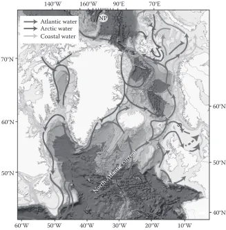
The general circulation of the northern North Atlantic is heavily influenced by the complex topog-raphy of the region (Figure 6). The most obvious feature is the NAc, which brings warm Atlantic water from the south-west. The NAc splits south of iceland, one branch heading north before split-ting again at the Denmark strait. The flow of Atlantic water along the west coast of iceland, through the Denmark strait and into the Nordic seas has the weakest, although highly variable, volume flux of the NAc branches. however, this current is of great importance to the regional marine climate of North icelandic waters. The average volume flux of Atlantic water in this curent is around 0.75 sv* with little seasonal variation.
The other main branch of the NAc flows north-east around the Faroe plateau carrying warmer water over the ridge between iceland and the Faroes. North-east of this ridge, the water meets the colder and less-saline waters of the East icelandic current and becomes confined into a fairly narrow current flowing eastwards over the northern slope of the Faroe plateau. on average, the Faroe branch transports volume flux of around 3.5 sv of Atlantic water. The shetland branch carries Atlantic water through the Faroe-shetland channel in addition to water recirculated from the Faroe branch. on aver-age the Atlantic water flux has been estimated at 3.2 sv with only a small seasonal amplitude of 0.2 sv and maximum flow in November. The remaining warm Atlantic waters of the NAc flow through the Faroe-shetland channel thence northwards parallel to the Norwegian coast. The warm waters then split into a gyre-like circulation in the barents and Greenland seas. some of its waters may deflect westwards into the northern Greenland basin and the boreas basin, but most recirculation occurs in the Fram strait. A smaller part of the west spitsbergen current eventually enters the Arctic ocean where it flows eastwards along the Eurasian continental slope. The boundary current continues around the Arctic ocean, although some of its water advects into the interior basins and forms the Atlantic intermediate layer. During this time, the Atlantic waters are subjected to seasonal cooling and mixing with cold, dense Arctic waters. The water of Atlantic origin is known as recirculating Atlantic water, and flows parallel with and partly underneath the cold and fresh polar surface waters, including sea
ice. This generates the return flow via the East Greenland current. Just north of iceland, a portion of the upper water masses and probably most of the bottom water in the East Greenland current turns eastwards into the iceland sea. The remaining part flows out of the Nordic seas through the Denmark strait. it is important to note that pacific water also enters the Arctic seas through the bering strait and becomes mixed into the waters flowing south to the Atlantic.
Further south the most striking oceanographic feature is the strong northwards-flowing shelf-edge current, which acts to limit exchange between the Atlantic and the continental shelf. There are very few measurements of cross shelf-edge flows which tend to be episodic and mostly wind driven, either due to local forcing or large-scale pressure effects. Flows on to the shelves are particularly important for the influx of nutrients but because of their large-scale and episodic nature, the best estimates of direct transport come from modelling. proctor et al. (2003) estimated that 0.7 Mt of nitrate entering the celtic sea region originated from across shelf-edge. internal waves generated at the shelf edge can mix nutrients vertically and if coupled with surface wind flow can be responsible for transport on to the shelves. in reverse, cascading occurs when shelf waters cool and become more dense than adjacent waters over the slope and this is a potentially important mechanism for exporting biogenic material to the deep sea. Evidence of individual cascading events has been found during various studies including shapiro & hill (1997).
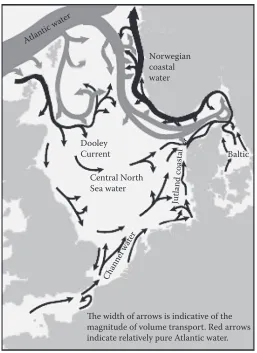
The mean currents of the North sea form a cyclonic circulation (Figure 7). The bulk of this circulation is concentrated to the northern part of the North sea due to major water exchange with
NP
G
Coastal water Atlantic water Arctic water
North Atlantic current
60°N
50°N
40°N 60°N
70°N
50°N
10°W 20°W
30°W 40°W
50°W 60°W
70°E 90°E
140°W 160°W
[image:12.504.88.415.67.399.2]the Norwegian sea. The circulation in the northern North sea can occasionally reverse into an anticyclonic pattern under persistent wind forcing (Dooley & Furnes 1981). The main inflow occurs along the western slope of the Norwegian Trench but significant inflows are also found around the shetland islands (Turrell 1992). less than 10% of total inflow to the North sea comes through the English channel. All of these inflows are compensated by the northwards Norwegian coastal cur-rent. because the western and southern regions of the North sea are strongly mixed by the tides, vertical shear values are relatively low. however, the movement of North sea bottom water has a strong seasonal signal in other parts of the North sea, with large areas becoming almost motionless during the summer. These areas are usually marked by depressed oxygen levels (to a minimum of about 65% saturation) and by temperatures similar to those of the preceding winter. This typically occurs in large areas of the central and northern North sea at depths greater than about 70 m. The situation is usually temporary as renewal of these deep waters occurs in the autumn. Areas per-manently stratified by salinity have a generally slow bottom water exchange. in the kattegat, the bottom water is renewed in 1–4 mo, the longest periods of stagnation occurring during summer. This slow renewal, in combination with eutrophication, frequently leads to periods of low oxygen content. The slowest movement of bottom water occurs in central parts of the skagerrak where
Atlantic water
Jutland coastal
Channel water
Baltic
The width of arrows is indicative of the magnitude of volume transport. Red arrows indicate relatively pure Atlantic water.
Norwegian coastal water
Dooley Current
Central North Sea water
[image:13.504.124.381.64.417.2]depths exceed 700 m. here, waters are normally replaced at a much slower rate (every 2–3 yr), but rapid changes can occur in winter if bottom water cascades into the Norwegian Trench.
Major biological patterns across the wider region: primary production
primary production by phytoplankton fuels the majority of marine food chains and overall sets upper limits to both the activity of the pelagic food web and the quantity of organic carbon exported to the benthos (Mann & lazier 2005). phytoplankton community structure is strongly influenced by physi-cal and chemiphysi-cal factors whilst the main losses are due to grazing (mostly by zooplanktonic organ-isms), sinking (Nielsen & Richardson 1989, Turner 2002) and viral infection (suttle 2007, brussaard et al. 2008). in the north-eastern Atlantic the growing season is strongly seasonal due to the annual light cycle and is accompanied by community successions as changing nutrient ratios favour particu-lar phytoplankton groups (colebrook 1979, 1982, Dippner 1998, McQuatters-Gollop et al. 2007a).
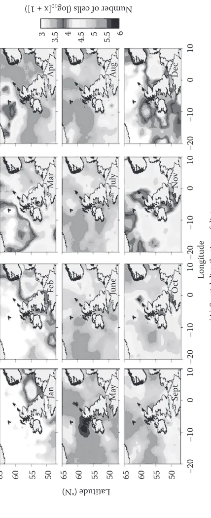
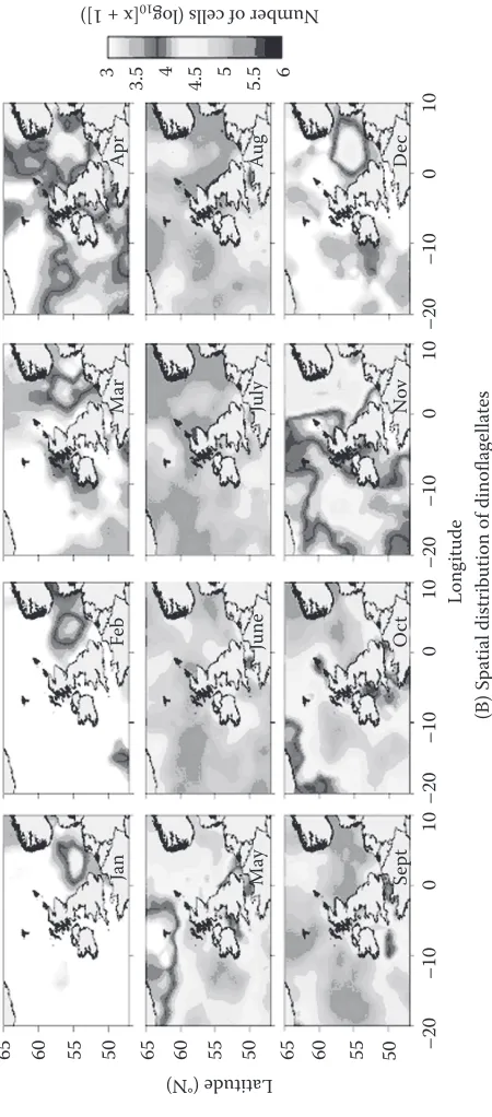
in midlatitude waters the classical picture is of a strong spring bloom dominated by diatoms, fol-lowed by a summer decline to a flagellate-rich community, folfol-lowed by a smaller autumnal bloom as increasing winds mix nutrients back into the euphotic zone (Figure 8). This view has largely come from samples collected by the continuous plankton sampler and latterly from satellite observa-tions (colebrook 1979, McQuatters-Gollop et al. 2007b). For those parts of the shelf seas subject to thermal stratification, the situation in summer is more complex as significant levels of primary production, not detected by surface sampling, take place just above the thermocline (Richardson et al. 2000, weston et al. 2005).
however, despite the transient spring period of high biomass and hence productivity and export, in many regions of the open North Atlantic, including the iceland and irminger basins, residual nitrate (>2 µM No3−) and phosphate (>0.15 µM po43−) concentrations have been observed dur-ing the post-bloom summer period (sanders et al. 2005). in addition these areas are characterised by consistently low chlorophyll concentrations during summer periods (henson et al. 2003). The atmospheric supply of iron and the surface water iron concentrations in these regions are very low and recent biophysical and experimental observations have now shown that iron limitation of the phyto plankton community occurs in northern Atlantic waters (e.g., in the iceland basin following the spring bloom) (Moore et al. 2006). As a consequence there can be incomplete removal of nitrate and hence a reduced efficiency of the biological carbon pump in this region.
with increasing latitude, the growing season becomes progressively shorter due to changes in illumination (Mann & lazier 2005). in the far north the bulk of production is concentrated into a single annual peak lasting only a few months. Again the spring bloom is diatom dominated (hegseth & sundfjord 2008) although in the Arctic ocean proper, smaller flagellates are more common. Recent reductions in sea ice between 1998 and 2006 have led to increases in open water area at the rate of around 70,000 km2 annum−1 with the greatest increases in the barents, kara and siberian sectors. Although pan-Arctic primary production averaged 419 ± 33 Tg c annum−1 during 1998–2006, recent increases in open water area have led to higher rates of annual production, which reached a 9-yr peak in 2006 (pabi et al. 2008).
65
(A) Spatial distribution of diatoms
Long
itude
60 55 50 65 60 55 50 65 60 55 50
Latitude (°N ) Se pt Oc t Nov De c Ma y Ja nF eb Mar Ap r June Ju ly Au g
3 3.5 4
4.5 5 5.5
Number of ce lls (lo g 10 [x + 1])
[image:15.504.127.341.114.639.2](B) Spatial distribution of dinoflagellates
Long
itude
65 60 55 50 65 60 55
Latitude (°N
) 50 65 60 55 50
–20
–10
0
Se
pt
Oct
Nov
De
c
Ma
y
Ja
nF
eb
Ma
rA
pr
June
July
Au
g
3 3.5 4 4.5 5 5.5
Number of ce lls (lo g 10 [x + 1])
6
10
–20
–10
01
0
–20
–10
01
0
–20
–10
01
0
F
ig
ur
e 8
(c
on
ti
nue
d)
[image:16.504.129.354.116.627.2]under the right circumstances the formation of phytoplankton blooms is common. Algal blooms are loosely defined phenomena, generally used to describe the accumulation of monospe-cific phyto plankton cell biomass through enhanced primary production. what constitutes an algal bloom is, however, not simply a biomass issue, as illustrated by blooms of toxic species (smayda 1997). phytoplankton species with relatively low per capita growth rates can still bloom if they escape grazing (strom 2008). Reduced edibility is often linked with size (long et al. 2007) or the production of phycotoxins (Turner & Tester 1997). interestingly, Phaeocystis globosa appears to be able to modify its morphology in response to the dominant consumers present (ciliates or copepods), a strategy that may reduce the level of grazing it suffers (long et al. 2007). blooms of phytoplank-ton differ in their magnitude and frequency with latitude and closeness to land. Furthermore, the Atlantic shelf seas are enriched with inorganic nutrients from terrestrial run-off, leading to concern about eutrophication (Andersen et al. 2006) and stimulation of harmful algal blooms (hAbs) in these areas (smayda 1997). A broad classification of hAbs distinguishes two groups of organ-isms: the toxin producers that can contaminate seafood or kill fish and the high-biomass producers that are considered ‘nuisance’ algae, causing anoxia, clogging fishing nets and affecting tourism. some hAbs have characteristics of both. Many of the toxin-producing hAbs are dinoflagellates. There are also concerns that, particularly in the shallow shelf seas, multiple stressors of climate change and anthropogenically altered nutrient ratios will lead to increases in the occurrence of hAb events (peperzak 2005).
Evidence has also emerged that a significant change in the primary production cycle in the central north-eastern Atlantic and North sea took place in the mid-1980s with an extended growth season and loss of the classic double peak in production (Reid et al. 1998). This is associated with a ‘regime change’ spanning all trophic levels and may have been caused by recent warming and changes in turbidity, altering phytoplankton community structure (McQuatters-Gollop et al. 2007b).
Major biological patterns across the wider region: secondary production
zooplankton includes a wide range of organisms (e.g., ciliates, chaetognaths, hydrozoa, cope pods and egg and larval stages of fish, bryozoans, echinoderms). zooplankton communities are often dominated by copepods (williams et al. 1994), which act as the key link between primary produc-ers and higher trophic levels and as a critical food resource for early-feeding larval fish (banse 1995). The population dynamics of individual zooplankton species is a product of their rates of reproduction, growth and mortality. Reproduction and growth patterns of zooplankton vary not only between species but also within species, reflecting regional dissimilarities in production cycles and thermal regimes. The timing of the zooplankton production cycle is an important factor for controlling phytoplankton growth (Fileman et al. 2007), for larval fish survival (cushing 1990) and for benthic-pelagic coupling (Townsend & cammen 1988). Much of our knowledge of large-scale zooplankton patterns has come from the continuous plankton sampler (barnard et al. 2004, warner & hays 1994) and the north-eastern Atlantic is unique globally in the long-term and broad spatial coverage of zooplankton distribution by this survey.
zooplanktonic metabolic responses to climate change, in particular warming, can be assessed using ecological metabolic theory. This considers how metabolic rates vary with body size and temperature (brown et al. 2004). Although mainly applied to terrestrial systems, this approach is emerging as a powerful tool in marine studies. For example, the metabolic theory can be used to predict variations in production and respiration and to evaluate how the primary production/ respiration rate and implied changes in carbon flux will vary with different climatic scenarios (lópez-urrutia et al. 2006).
Ocean currents as the major mechanism linking
the regions in the north-eastern Atlantic
The role of ocean currents in the transport of nutrientsThe traditional concept was that availability of nitrogen was the primary control on phytoplankton growth but for the North Atlantic, the general picture that is emerging is of a latitudinal gradient with nitrogen-deficient systems in northern parts and a shift towards phosphorus deficiency in the south. The present understanding is one of a biological control of the nitrogen/phosphorus balance in which the nitrogen content adjusts to the phosphorus content via the two opposing processes of nitrogen fixation and denitrification (Tyrrell 1999).
For the Arctic inflow around Greenland, the nitrogen deficiency seems at least partly to origi-nate from the bering strait and chukchi shelf regions, where high sedimentation rates combined with shallow depths produce low-oxygen environments that favour denitrification (carmack & wassmann 2006). Denitrification appears to function relatively efficiently at low temperatures, as illustrated by the detection of denitrification and an-ammox (anaerobic ammonium oxidation) activity in Arctic sea ice (Rysgaard et al. 2008). Adaptation to temperature appears to be a strong selective force among diazotrophs (nitrogen-fixing bacteria), as demonstrated by the distribution of different nifh phylotypes according to temperatures in the southern North Atlantic (langlois et al. 2008). Despite evidence that low temperature per se is not inhibitory to nitrogen fixation (karl et al. 2002), nitrogen fixers appear to be absent in cold marine waters (staal et al. 2003). presumably as a consequence of this, nitrogen deficiency is conserved in the Arctic and a low nitrogen/phosphorus signal is still a characteristic feature of water when it leaves the Arctic ocean in the East Greenland current (Daly et al. 1999).
For the shelf seas, inflow from the Atlantic is crucial since it has been estimated that around 90% of nitrogen and phosphorus inputs to the North sea come from this source (ospAR 2000). however, much of this nitrogen is in the non-reduced form and so not readily available for primary production. in addition there are large intra- and interannual variations in the inflow.
The role of ocean currents in the transport of carbon between the four systems: shelf pump
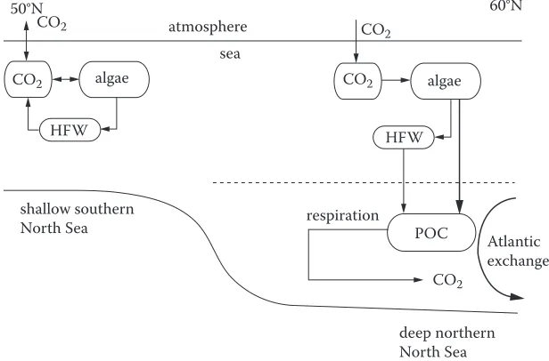
According to the inventory of sabine et al. (2004), the North Atlantic basin stores 23% of the global oceanic anthropogenic co2 despite covering only 15% of the global ocean area. The adjacent shelf seas are also efficient at drawing down atmospheric co2 and thus play a key role in the global car-bon cycle. in the North sea there is a separation in carcar-bon processing of the shallower southern area from the deeper northern waters (Figure 9). carbon export occurs in the deeper northern waters, particularly during the summer as particulate organic carbon from algal production sinks to the deeper, cooler waters. heterotrophic respiration below the thermocline releases co2 into the water, where a substantial fraction is transported northwards by the subsurface circulation. According to Thomas et al. (2005), 90% of the co2 absorbed in the North sea is exported to the North Atlantic. The Atlantic water entering the North sea through the orkney shetland gap thus gains approxi-mately 40 mmol c kg−1 before leaving the North sea. During late summer the outward carbon transport via the Norwegian trench is approximately 2.2 × 10¹² g c, while in the same period the North sea absorbs approximately 15% from the atmosphere.
Export of carbon from the North sea occurs because the thermal stratification of the northern sec-tion of the sea allows particulate organic carbon from algal producsec-tion in the warmer surface waters to be exported down into the cooler subsurface layer. Most of the co2 that is subsequently released from heterotrophic respiration of this particulate organic carbon is transported northwards to the
60°N
algae
Atlantic exchange
deep northern North Sea shallow southern
North Sea
sea
respiration
HFW HFW
POC algae
atmosphere 50°N
CO2
CO2
CO2
CO2
CO2
[image:19.504.97.405.392.595.2]North Atlantic ocean by subsurface ocean circulation (Figure 9). The shallower non-stratified south-ern section does not contribute to this carbon transport since both algal production and heterotrophic respiration occur within the year-round mixed water column, thus preventing significant exports.
The findings of Thomas et al. (2004a) were based on four cruises spread across a year to reveal seasonal and spatial patterns. The seasonal variations of partial pressure differences (Figure 10A) were measured and interpolated for 13 sectors of the North sea (Figure 10c) and coupled with measurements of the seasonal variations in co2 flux (Figure 10b) to enable the spatial patterns in annual co2 flux to be calculated (Figure 10c).
This study showed that the North sea as a whole acts as a co2 sink all year round. The only source is from the southern areas (sectors 1–4) during the late summer (Figure 10c). The greatest drawdown occurs in May during the spring algal blooms, and secondly in october, when storms force co2 uptake. only about 1% of carbon captured by the algae is sequestered in the North sea sediments; the majority, as described, is exported to the North Atlantic ocean.
based on these studies the significance of the North sea shelf pump for the sequestering of car-bon is well established. The effects of global warming on the efficiency of the shelf pump are, how-ever, unclear. A longer stratification season due to warming may further reduce the flux of nutrients to the surface layer. As a result, primary production after the spring bloom and a restructuring of the phytoplankton community may occur. Furthermore, the increased stratification has the potential to increase the dominance of the microbial loop thereby recycling carbon in the surface layer and potentially resulting in a reduced flux of organic material to the deep layer. Thus, carbon outflows due to the shelf pump will probably be reduced, limiting the efficiency of the shelf pump and the contribution of this mechanism to the sequestration of carbon.
2 4 10
50 –50 –100 0.4 0.2 –0.2 0.0 C O2 Flu
x (mol m
–2 m
on th –1) ∆pC O2 (10
–6 atm)
0 13 A B = Cruises = Cruises 2
j f m m jn jl a s o n d j Month
a
In
Out
j f m m jn a o d –0.5 0.0
Out
5°W 5°E 10°E 50°N
55°N 5 6 7 8 9 10 11 12 13 3 4 2 60°N C 50°N 55°N 60°N 0°
5°W 0° 5°E 10°E
In 0.5 1.0
CO2 Flux (mol m–2 a–1)
1.5 2.0 2.5 j n s jl Month a
4 10 13
[image:20.504.66.445.70.302.2]The role of ocean currents in the transport of phytoplankton and microzooplankton
The phytoplankton communities of the north-eastern Atlantic are strongly influenced by the inflow of Atlantic water into the North sea and the Nordic sea (skogen et al. 2007). wind conditions asso-ciated with the NAo also affect the development of the upper mixed layer and thus phytoplankton productivity. As demonstrated in freshwater lakes this may potentially affect their nutritional value to higher trophic levels (Diehl 2007). Modifications in vertical mixing and stratification may also alter species composition and the export of primary production to deeper waters.
As discussed on page 12 there is a large interannual variability in the flux of Atlantic water entering the shelf seas. Although this advection transports oceanic phytoplankton cells to different locations, it is the local conditions that determine whether these species can become established in new areas (hegseth & sundfjord 2008). in the north-eastern Atlantic there is a weaker latitudinal gradient in temperature compared to the north-western Atlantic. Nevertheless, this weaker gradient can still set barriers to the long-term survival of phytoplankton species but serial seeding can lead to significant temporary range extensions (Edwards et al. 2002). For example, Johnsen et al., (1997) described an advection event that resulted in a widespread bloom of the normally oceanic Ceratium furca that persisted over a 6-wk period and reached mid-Norway (63°N). however, blooms may propagate over wide distances without advection. since many of these organisms produce resting stages or are present at very low population levels in seawater, blooms can initiate if environmental conditions become optimal. For example, a bloom of the coccolithophorid Emiliania huxleyi started in Norwegian coastal waters at 60°N and passed the Arctic circle (70°N) 3 mo later (hegseth & sundfjord 2008). because some bloom-forming species interfere with human activities such as aquaculture, more attention is now paid to monitoring their occurrence, particularly in coastal waters. increased frequency of recorded hAb outbreaks may be related to factors such as enrich-ment of coastal nutrients but may just reflect increased monitoring and human activity in the coastal zone. periodic incursions of warm-water phytoplankton into Norwegian waters have certainly been noted since the early 1900s (smayda 1958).
The role of ocean currents in the transport of mesozooplankton
replenished on an annual basis from the oceanic population centres in the north-eastern Atlantic and the Norwegian sea (heath et al. 1999). During the winter, preadult fourth and fifth copepodite stage (civ, cv) individuals are found at depths of 200–1500 m (heath et al. 2004) and remain there in a suspended, diapause-like state (hirche 1996) in which they subsist on stored lipids (Jónasdóttir 1999). in the spring they rise to the surface, moult to the adult stage, and begin reproduction (heath & Jónasdóttir 1999). The number of generations per year varies between one and three depending on temperature. During the surface reproductive phase, C. finmarchicus is transported into the shelf seas. in these shelf regions the individuals of the species play a significant ecosystem role as grazers and as a major food source for larval fish (heath & lough 2007, Rowlands et al. 2008). This life cycle has two important implications in relation to regional interconnectivity. Firstly, although C. finmarchicus is ecologically important on the shelf, it is essentially an oceanic species. secondly, its demography is fundamentally affected by circulation (and changes in circulation) in both surface and deep currents.
The ocean-shelf linkage is also potentially the key to understanding the relationship between the negative correlation between the winter NAo index and the abundance of C. finmarchicus and the weaker positive relationship with the abundance of its warmer water congener C. helgolandicus on the shelf seas (Fromentin & planque 1996). originally Fromentin & planque (1996) attributed the relationship to the fact that more positive winter NAo years typically experience higher tem-peratures and westerly winds, both of which would affect primary production, and that this favours warmer water species such as C. helgolandicus. subsequently, stephens et al. (1998) suggested that periods of negative (low) NAo were associated with stronger inflows of Atlantic water to the North sea, which would lead to increased transport of C. finmarchicus from the Norwegian sea. This hypothesis was further developed to a basin-scale context by Greene & pershing (2000). sundby (2000) suggested that the variable advection of C. finmarchicus from the core production area of the Norwegian sea to the North sea and the barents sea is an important factor influencing the recruit-ment of cod stocks. however, kimmel & hameed (2008) have recently questioned the strength of the statistical link between C. finmarchicus abundance in the north-eastern Atlantic and the NAo.
heath et al. (1999) showed that the wyville-Thompson Ridge forms an effective physical barrier for overwintering C. finmarchicus, with much higher densities occurring in the Norwegian basin and Faroe-shetland channel than to the south of the ridge. During winter, diapausing C. finmar-chicus in the Faroe-shetland channel are concentrated below the pycnocline in Norwegian sea Deep water (NsDw). During negative winter NAo years winds tend to come from the north-west, favouring production of NsDw and advection of C. finmarchicus into the Faroe-shetland channel. however, the well-behaved negative relationship between the winter NAo index and C. finmar-chicus broke down in 1996 and 1997 (planque & Reid 1998). This appears to be because NsDw production also integrates climatic conditions on a decadal timescale. in 1996 the NAo was strongly negative but following an extended positive period; the abundance of C. finmarchicus in the North sea remained small because although transport into the North sea was favoured, the NsDw over-flow remained small (heath et al. 1999). The links between the atmospheric drivers and C. finmar-chicus are mediated by responses to changes in both deep water (affecting the overwintering stages) and surface water circulations and these respond over different timescales.
for a well-mixed population, this comparison provides a rough estimate of whether a region can independently sustain a population. in all cases the biological rate of increase was at least an order of magnitude greater than the advective renewal, and that less than 5% of the annual production in the Nordic seas was lost from the system.
The dominance of biological rates over physical ones is also apparent in modelling studies. speirs et al. (2006) constructed a spatially explicit coupled physical/biological model of C. finmar-chicus over its entire geographic range. Development rate and fecundity were driven by a yearly cycle of temperature obtained from the ocean circulation and Advanced Modelling project (occAM) ocean circulation model (De cuevas et al. 1998) and of phytoplankton carbon derived from bottle samples and seawiFs (sea viewing wide-Field of view sensor) satellite data (clarke et al. 2006). population control was achieved by density-dependent mortality, which they showed needed to be temperature dependent to match cpR data. The spatial transport of Calanus was calculated from the occAM flow fields together with an assumed horizontal dispersion. in one experiment speirs et al. (2006) switched off transport entirely and then ran the model to a quasi-stationary state. The results indicated that transport had a relatively minor impact on the distribution of Calanus in the sense that the two major population hot spots in the Norwegian sea and the subpolar gyre persisted. by contrast, transport was of major importance in extending the population range. The most dra-matic impact is in the northern Norwegian sea, where sea ice prevents sustainable populations in the absence of seasonal influxes of animals.
in a second experiment relating to large-scale transport, speirs et al. (2006) simulated the prop-agation of Calanus inocula in the Norwegian sea gyre and the subpolar gyre. within 2 yr the indi-vidual gyre systems were populated. by the third year the Norwegian sea population had become entrained in the Greenland coastal current and was transported through the irminger sea and into the subpolar gyre. in both cases the model had nearly reached its fully populated steady state after 5 yr. This surprisingly short invasion timescale suggests a very high level of connectivity, despite the fact that the large-scale demographic impact of transport is limited. These two observations can only be consistent if the environmental factors driving the demographics show coherence over spatial scales at least as large as the distances travelled by individual Calanus during their genera-tion time.
high-dispersal capacity coupled with the lack of physical barriers suggest that many marine species with pelagic stages should show weak population genetic structuring (palumbi 1994). however, the very large scale of the geographic distributions of certain mesozooplanktonic species, together with the possibilities of gene-flow restriction mediated by gyre systems, introduces the potential for regional genetic isolation. To date the evidence for significant genetic differentiation in C. finmarchicus across the Atlantic is at best equivocal. bucklin & kocher (1996) reported the same mitochondrial 16s ribosomal DNA genotypes in both the eastern and western Atlantic but using the same markers found significant variation within the Georges bank region. using different markers, bucklin et al. (2000) revealed differences between Atlantic and Arctic C. finmarchicus popula-tions in icelandic waters. More recently more sensitive microsatellite markers have been developed (provan et al. 2007). provan et al. (2009) used these together with a part of the cytochrome b (cyTb) gene to estimate gene flow across 14 sites in the Norwegian sea gyre, the irminger sea gyre and the North Atlantic off Nova scotia. They concluded, contrary to previous studies, that there was no evidence for genetic differentiation across the main population centres for C. finmarchicus.
physical/biological models that include a genetic model. Although less intensely studied, oceanic transport into shelf seas is also likely to be a key factor in the ecology of other important mesozoo-plankton such as Calanus helgolandicus (bonnet et al. 2005, helaouët & beaugrand 2007).
The role of ocean currents in the transport of macro- and megazooplankton
Macro- and megazooplankton are planktonic organisms larger than 2 cm (harris et al. 2000). This diverse group includes tunicates, chaetognaths, euphausiids and gelatinous zooplankton and ich-thyoplankton but because of its importance for fisheries, the transport of fish larvae is dealt with in a separate section.
it has long been known that marine organisms can be used to characterise water masses and many marine biological studies during the early twentieth century adopted this approach. At this time there was a marked warming of coastal waters associated with a positive phase of the NAo and AMo. cushing (1982) has described how during this period (1920s–1930s) unusual numbers of surface-living and pelagic subtropical animals were transported to the western british isles. in the waters off plymouth (south-western England) it had been noted that the chaeotognath Sagitta setosa was characteristic of English channel water whilst its congener S. elegans typified warmer Atlantic water. changes in the relative abundance of these two species at the E1 observatory have been con-sistent with changes in sea temperature and with wider ecosystem effects (hawkins et al. 2003).
Throughout the north-eastern Atlantic there are numerous records of periodic outbursts of gelatinous zooplankton. whilst there have been several claims that the rate of outbursts may be increasing, due to climate change, overfishing or increases in the availability of hard surfaces required by the planulae larvae (Mills 2001), these claims are hard to verify. Macrozooplankton have generally been poorly monitored in the past, giving at best a fractured baseline to compare with modern observations (purcell et al. 2007). in addition, these organisms are characterised by pulsed population dynamics (boero et al. 2008). Most observations come from the shelf seas where species may either be endemic (e.g., Aurelia aurita) or oceanic or warmer water species advected into the shelf seas. As well as potential poorly understood impacts on overall food web structuring (Mills 2001), blooms of gelatinous zooplankton can have direct impacts on human activites such as fishing, fish farming and tourism. For example, båmstedt et al. (1998) reported a mass outbreak of the siphonophore Apolemia uvaria along the western Norwegian coast that caused deaths of farmed salmon. This species has a near-global distribution being normally found in offshore waters down to depths of 800 m. Apolemia was therefore probably transported from the open Atlantic along the Norwegian coast (Figure 11). Mass invasions of oceanic species associated with increased influx of North Atlantic water on to the European shelf seas and into Norwegian coastal waters are not uncommon. in summer of 2007 a similar event was reported in the popular press involving the oceanic species Pelagia noctiluca (heard 2005) that resulted in complete destruction of a salmon in a sea farm off northern ireland.
The role of ocean currents in the distribution of fish across system boundaries Transport of fish eggs and larvae
distances for individuals will range from tens to hundreds of kilometres (van der Molen et al. 2007). however larval behaviour and oceanographic features can act to restrict dispersal so that a sig-nificant portion of offspring are retained close to their natal origins—potentially generating self-recruiting populations. whilst self-recruitment has been most widely studied in tropical reef fish (Almany et al. 2007) it is also a feature for some temperate species. For example, iles and sinclair (1982) proposed that larval retention by oceanographic features, predominantly fronts, was a key mechanism for maintaining genetically discrete substocks of Atlantic herring (Clupea harengus). because of their small size and extended planktonic durations there are few direct observations of fish larval dispersal except where population size and dispersal range are sufficiently small to allow observation or mass marking and recapture (Almany et al. 2007). Most estimates of dispersal dis-tances have been inferred from knowledge of water currents potentially linking known spawning areas and nursery grounds. More recently coupling of oceanographic computer models with particle tracking has allowed more formal testing of these transport paths, including seasonal and interan-nual variability. Although such models may adequately simulate the dispersal of the essentially passive egg stages, incorporating responsive larval behaviour remains a challenge (vikebø et al. 2007a). Even for well-studied species such as European plaice Pleuronectes platessa (Fox et al. 2006) or walleye pollack Theragra chalcogramma (olla et al. 1996) there is limited understanding of how individual larvae react to environmental cues and trade off the risks of obtaining adequate food against predation (vikebø et al. 2007a). Experimental studies of temperate fishes have also
70°N
65°N
3
5
6 7
8 9 1011
4
1 2 200
200
500
200 500
500
NORWEGIAN SEA
Svin y transe
ct
NORWAY
NORTH SEA 60°N
10°W 0° 10°E 20°E
[image:25.504.98.407.62.373.2]tended to focus on a limited range of commercially important species (leis 2007). because of this we probably underestimate the variety of behaviours, and thus transport pathways, utilised by the early life stages within fish communities as a whole (van der Molen et al. 2007). Despite these problems, particle-tracking models have provided important insights into the transport of early life stages of several fish species in European waters. Most examples suggest drift to be contained within EuR-ocEANs’ systems. For example within the North sea, the transport of plaice eggs and larvae across the southern North sea is relatively well understood (van der veer et al. 1998) whilst it is known that residual currents transport haddock eggs and larvae from spawning grounds off the north-west of scotland, around the northern tip of the united kingdom and into the northern North sea (heath & Gallego 1998). off Norway the northwards drift of cod eggs and larvae from spawning grounds around the lofotoen islands, including aspects of larval behaviour has also been relatively well studied (vikebø et al. 2007a). here there is a clear influence of regional linkage since vikebø et al. (2007b) modelled the impact on Arcto-Norwegian cod of a slowdown in the Moc. According to their model results, a 35% reduction in the Moc would result in a southwards and westwards shift in the distribution of cod year classes from the barents sea on to the narrow shelves of Norway and spitsbergen, reductions in individual growth of the pelagic juveniles and in increasing numbers of larvae and pelagic juveniles being advected towards the western parts of spitsbergen, and pos-sibly further into the Arctic oceans, where they are would be unable to survive.
As well as the indirect effects of regional linkages, some species cross between EuR-ocEANs’ regions. one of the best-known examples is the European eel (Anguilla anguilla). Following spawn-ing in the south-western sargasso, the larvae (leptocephalii) drift across the open Atlantic (wang & Tzeng 2000). when the leptocephalii reach coastal waters, they metamorphose into glass eels, which move into estuaries and rivers. Eel populations within European rivers have declined catastrophically since the 1980s and processes occurring in the open ocean, such as shifts in the track of the North Atlantic drift, may be behind this decline (Feunteun 2002, bonhommeau et al. 2008). The importa-tion of Japanese eels (Anguilla japonica) for cultivaimporta-tion trials has also introduced a parastitic nema-tode (Anguillicola crassus). This nemanema-tode is now widespread in Europe but its impacts on native eel stocks are not known (kennedy & Fitch 1990). The European eel thus provides a strong example of where both life history linkages between the Atlantic and the shelf seas and the dispersal of alien species within the shelf seas are of key importance. in terms of transregional linkages, mackerel and blue whiting provide further examples of commercially important species. starting in February, north-eastern Atlantic mackerel spawn progressively from the bay of biscay up the shelf edge and spawning ends around July off the west of scotland (bartsch & coombs 2004). Model-based particle tracking suggested that although most of the larvae drift northwards in the Atlantic current, a smaller proportion are transported southwards and the location of the division that separates the drift routes varies interannually depending on the hydrographic conditions (skogen et al. 1999).