International Journal of Innovative Technology and Exploring Engineering (IJITEE) ISSN: 2278-3075, Volume-8 Issue-9, July 2019
Abstract: People have invented different solutions to find out the location of a person or an object on the earth. In the beginning, mariners used angular measurements to calculate their location for celestial bodies such as the sun and stars. In the earlier 1920s, implemented a more sophisticated radio navigation scheme depends on radio waves that give access to the navigators to determine the direction of the transmitters. Soon after, the advancement of satellites made it achievable to transmit with high accuracy, line of sight radio navigation signals created a new era in the technology of navigation. To find the position of an object, a 2-dimensional navigation system called transit was used in olden days. This method was to set the basic building blocks to introduce the global positioning system. This new GPS concept provided outstanding innovative methods to find the position of an object to the public, scientists, military, etc. The predominantly GPS known as Global Positioning System is a range-based positioning system that yields an obscure object's 3D position on top of the earth. This system collects estimates or range data from realized emanating sources to determine the position of obscure objects and the system is also called as a positioning system based on satellites. The precision of the object location frequently relies on the error of the satellite clock, atmospheric delays, multipath, positioning of the satellite, noise and multiple parameters of the receiver. Mostly, none of the above parameters have consistent behavior worldwide and should be checked to provide an exact solution. This paper mainly focuses on the study of GPS evolution, error sources, popular accuracy measures and positioning services of GPS.
Index Terms: GPS, accuracy parameters, precision, line of sight, multi-path, clock error, atmospheric delay.
I. INTRODUCTION
In general, the original GPS signal transmitted by the satellite consists of various errors and noise that need to be considered while finding the position of an object with high accuracy in terms of latitude, longitude, and altitude. The most prevalent issue with GPS is precision. Precision relies on the signal the time unit sends. The precision in the GPS unit becomes troubled when the time is off. When it meets harsh atmospheric circumstances, the time and calculations are impacted. Inaccuracy happens when a signal from hills, skyscrapers, etc. is bounced back. Another issue is its position which is being updated [1][2]. The satellite cannot
find out the right place once the signal has reached the time it needs, and can then perform a calculation based on the incorrect data.
A.Objectives
The following elements were presented in this paper Revised Manuscript Received on July 9, 2019.
P Sirish Kumar, Department of Electronics & Communications Engineering, Aditya Institute Of Technology And Management, Tekkali,Srikakaulam, India.
V B S Srilatha Indira Dutt, Department of Electronics & Communications Engineering , GITAM University, Visakhapatnam, India.
i. Evolution of the Global Positioning System [1][3] ii. Analysis of GPS Precision Vs Accuracy [4][5][6] iii. Statistical Error Analysis[4][8]
iv.
GPS Error sources and Positioning Services [7][8][9]
II. PERTINENTWORK
This paper is mainly vivid and primarily depends upon the information gathered from various books, journal articles, numerous newspapers, and websites.
A.Stochastic Review on Published Articles have been Scrutinized Associated To Our Analysis
i. R.S Chhillar & P.Singa.in 2014 [10] directed an examination ponder on the different uses of GPS in Computer Science Engineering like remote sensing, Image & video processing using cell phone, and finding the location of the vehicle in fisheries, marine investigations.
ii. J.S. Bhatia & P. Verma in 2013 [11] stated in their paper that the GPS is increasing its ability to track the vehicle with high accuracy and also in web applications.
iii. D.Yu& S. Hwang (2012) [12] assured in their study that the technology in navigation is getting to be a standout amongst the most significant highlights in mobile phones and smart phones. Individual location and areas are developing the extent of cell phones.
iv. H. M. Bandland, Duncan. M. J& W. K. Mummery in 2008 [13] finding the utility of most popular GPS has been widely used in the fitness- associated physical movement etc.
B.A Shared National Attribute: The Global Positioning System
The Global Positioning system was initially developed by the U.S. armed forces to perceive the exact location of an unknown object in some national security applications. They also maintain another encrypted signal which is degraded the accuracy for civilian users. In general, GPS provides positioning information,speed and timing information is utilized for a large number of new and innovative applications that the initial scientists have not anticipated. For these reasons, GPS has strictly considered as a dual-use system prevalently utilized by both the defense and civilians. If GPS used as a dual-use system, it undoubtedly needed some trade-offs between civilian users and the defense department.
A Hypothetical Analysis on GPS Evolution,
Error Sources, Accuracy Measures and
Positioning Services
The results of the technical part of the research carried out by the Committee of the National Research Council on the future of the Global Positioning System are reported in this article. In looking at future upgrades to the GPS, the NRC advisory group tried to adjust the highlights that would improve common applications against the unmistakable prerequisite to keep up the military respectability of the system. The suggestions in the report were expected to meet this basis [14].
III. BASICCONCEPTOFGPS
The GPS has 24 satellites orbiting the earth, providing positioning and user velocity on or above the surface of the earth. The system offers user data 24 hours a day, regardless of weather and geographic circumstances [1]. Although GPS was initially designed as a vehicle and ship navigation, aircraft and missile monitoring and guidance in US military applications, it now has access to a broad spectrum of applications accessible for the general public [15].
The Global Positioning System is initially a portion of Navigation System with Timing and Range (NAVSTAR) that was utilized for the purpose of different security and civilian applications. The idea of GPS previously introduced in the late 1960's nevertheless the main satellite was launched in the year 1978 and the last one in the arrangement of 24 earth orbiting satellite was set into space in June of 1993. Its fundamental object was uniquely for military reasons including 24 hours navigation abilities for naval force and flying corps. From that point forward it has turned into a significant part in different non-military personnel applications, enterprises, and recreational exercises [15]. Worldwide Positioning System (GPS) is created and now totally worked by the United State's Department of Defense. From the advancement of this innovation, it’s been generally utilized in everywhere throughout the world for different reasons and now a standout amongst the most prominent innovation of this twenty-first century [26]. Even though the worldwide positioning system is free for regular citizen use yet for the business reason one needs to pay an extensive sum as indicated by its utilization.
A. Civilian Applications of Low Cost GPS Receivers GPS is the preferred solution for a broad and increasing variety of civilian applications [9][17], coupled with free worldwide accessibility and precision of GPS signals for positioning and timings and the low price of receiver chipsets [1][2].
i.Shipping & Rail Transport
Sea and shore navigation, dredging, harbor access and docking, vessel traffic services (VTS), automatic ID system (AIS) as well as load handling applications include marine applications. Railways include rolling stock management, passenger information, door prevention, cargo tracking signals, the integrity of trains, and level crossing approaches until the door is opened on a platform side.
ii.Science
GPS scientific applications are common and include atmospheric and environmental monitoring, animal behavioral studies, place of botanical specimens, meteorology and weather research. The GPS is used to map the soil, to monitor plants precisely, spray and harvest,
autonomously control the car and to monitor fishery boundaries in agriculture and fishing.
iii.Security
The safety applications include vehicle tracking, containers, additional precious freight, and hidden suspect tracking.
iv.Aviation
In business aeronautics, most aircraft by utilizing GPS for transit route and GPS is logically being used for beginning technique and a non-accurate approach to manage decided runways. Automatic Dependent Surveillance-Broadcast (ADS B) is being developed comprehensively as the favored future advancement for business flying specialists; this incorporates plane processing their position using GPS and broadcasting it to different aircraft.
B. Different Navigation Systems
i.NAVSTAR GPS: It is implemented in three stages [1][3]. Stage 1: Validation of Concept has been carried out
during 1973-1979
Stage 2: Complete improvement and testing has been carried out during 1979-1985
Stage 3: Stage 3: Invention and exploitation have been carried out from 1985 to now.
ii.GLONASS: This project GLONASS represents the Global Navigation Satellite System and is worked by the Russian Defense Ministry. The program was first begun by the previous Soviet Union and is today under the sponsorship of the Common abundance of Independent States (CIS). The initial three test-satellites were propelled into space on October 12, 1982.
iii.Galileo: The space section of Galileo will comprise of 30 satellites (3 of which will be dynamic save satellites). They will be set in orbits at a height of 23,616 km accommodating overall inclusion. The satellites (each with a weight of 680 kg and measurements of 2.7 m x 1.2 m x 1.1 m) will be equitably circulated more than 3 orbital’s, having an edge of 56° to the equator and an orbital time of 14 hours and 5 minutes.
iv.BeiDou: It is China’s regional system, presently having access to Asia and the West Pacific.
v. COMPASS - China's GNSS intended to be launched by 2020.
vi. IRNSS: Indian Regional Navigation Satellite System, covering India and, Northern Indian Ocean.
vii.QZSS: It is a Japanese regional system covering Asia and Oceania.
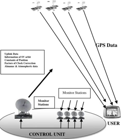
C. GPS CONFIGURATION
The GPS incorporates three major functional units [1]. Space unit: It consists of the information related to satellite constellation.
Control Unit: It tracks every satellite, and continuously uploads the ephemeris data, clock correcti0ons and various parameters related to navigation.
User unit: It examines the 3-D position and local time.
International Journal of Innovative Technology and Exploring Engineering (IJITEE) ISSN: 2278-3075, Volume-8 Issue-9, July 2019
GPS Data
CONTROL UNIT
Figure 1: The three GPS Functional Units i.The Space Unit is intended to give worldwide inclusion
utilizing at any rate 21 satellites in medium earth circle (MEO) out of absolute 32 operational satellites. Among them 3 are extra. These satellites are arranged in 6 orbital planes at a stature of 20,200 km over the outside of the earth. The orbital period is 11 hours 58 minutes and the orbital planes are slanted at a point of 55o w. r. t tropical plane.
ii.The Control Unit comprises of an ace control station, screen stations, and ground control stations. There are five screen stations in GPS. The control section tracks each satellite and occasionally transfers to the satellites, forecast of ephemerides, clock rectifications and other navigation information parameters.
iii.The user Unit incorporates all military and non-military peoples. The User unit contains the GPS receivers which are used to track the signals of particular satellites selected and examined the 3-D position of an object.
IV. GPSERRORSOURCES
To understand how GPS functions and to know how large an error should be anticipated, the evaluation of errors calculated using the Global Positioning System is essential. Receiver’s clock incorrect timekeeping is the fundamental GPS error source [18]. The common error sources are satellite clock error, orbital error, light speed, the transit time of the signal, satellite geometry, multipath effect, and atmospheric effects. A microwave radio signal travels with the speed of light. Minimum four satellites are required to compute the position of a user. Another problem is satellites use the atomic clock whereas receivers used normal clock which synchronization doesn’t happen between these two. The solution to this problem is to utilize an atomic clock in GPS receivers which costs around $100000[5] [6].
A.Error Consideration
Until now, error components have not been taken into consideration in calculations. Several causes of GPS can lead to a general error [8].
i. Satellite clocks: While a time error of just 10 ns is created in the order of 4 atomic clocks on each of the satellites. ii. Satellite orbits: The satellite's position is usually only
known approximately One to five meters.
iii. Speed of light: At the light speed of the user, the satellite signals are transferred. This lingers when the ionosphere and troposphere are crossed and thus cannot be considered as a permanent more.
iv. Measuring signal transit time: If the Satellite transmitted signal will be received within a time 10-20 nsec then only possible for the user to determine the measuring signal transit time which is equal to 3-6 meters position error. v. Satellite geometry In case four satellites are being utilized
to make measurements are near together, the capacity to determine a position deteriorates. GDOP [16] is the impact of satellite geometry on precision measurement.
[image:3.595.36.271.53.322.2]The errors are triggered by several variables described in Table 1, including horizontal error data. Also provided are 1 sigma and 2-sigma. The precision of the average constellation of the satellite (DOP value) is in most cases better than indicated [19].
Table 1: Cause of Errors
Error Values
Ionosphere 4mts
Troposphere 0.7 mts
Multipath Effect 1.4 mts
Measurements of Receiver 0.5 mts
Total RMS Value-Unfiltered 5.3 mts
Satellite Clocks 2.1 mts
1 Sigma (68.3%) –Horizontal 10.2 mts 2 Sigma (95.5.3%) –Horizontal 20.4 mts
1sigma (68.3%) -vertical 12.8 mts
2sigma (95.5.3%)-vertical 25.6 mts
Ephemeris Data 2.1 mts
Total RMS Value-Filtered 5.1 mts
B.The Dilution of Precision(DOP)
The precision with which a location in navigation mode can be obtained by utilizing GPS on the one side relies on the precision of the pseudo-range measurements, and the geometry of the satellites being used on the other. This occurs in a scalar number called DOP (Dilution of Precision) [16] in the navigational literature.
In present use there are several DOP names:
•Geometrical DOP-Positioning in three-dimensional space • Positional DOP – Positioning in three-dimensional space • Horizontal DOP-Positioning on a Plane
•Vertical DOP - Only Height
Some observations precision depends proportionately on the value of DOP [27]. Therefore when doubles the value of DOP, there is a two-factor error in determining a location. USER
Monitor Stations
Monitor Stations Uplink Data
a. Good satellite shading
[image:4.595.66.267.60.331.2]
b. Poor satellite shading
Fig. 3 Illustration of Satellite-receiver geometry for four satellites
[image:4.595.52.284.400.498.2]From figure 3 [25] we can understand that Positional DOP is a reciprocal value of the satellite geometry, created by the satellite and user roles. When the quantity is at peak and PDOP minimum, the best geometrics scenario happens. Numerous DOP ratings [27] are tabulated in Table 2.
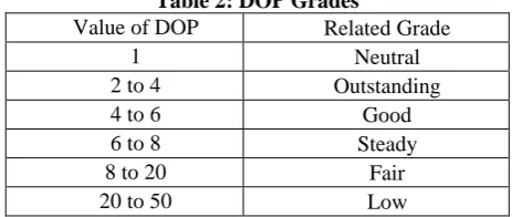
Table 2: DOP Grades
Value of DOP Related Grade
1 Neutral
2 to 4 Outstanding
4 to 6 Good
6 to 8 Steady
8 to 20 Fair
20 to 50 Low
V.POPULAR ACCURACY MEASURES
Table 3 records the most normally utilized GPS position accuracy measures and their definitions. Note that the initial two strategies are clarified regarding a normal squared error, and the last 3 are characterized legitimately from the position error probabilities. Along these lines, we can quickly connect these last three with error probabilities. On the off chance that we expect that the blunder conveyance along with any pivot is "ordinary" or Gaussian, at that point we can likewise determine probabilities related to the RMS and 2DRMS accuracy measures[5][6][19].
A.Distinct Approaches to Enhance the GPS Accuracy
Some popular techniques like the Recursive Least squares estimator [22], Kalman filter [20][23], Reference Station
Networks[21], Perceptive GPS[4], Particle Filter[25], Map Matching Algorithm[24] are available to enhance the GPS Precision. The most prevalent approaches Reference Station Networks, Perceptive GPS are discussed in this section.
i. Reference Station Networks: Reference stations depend on the ground are networked together to determine the discrepancy between the predicted positions designated by satellites and the actual positions [21]. To enhance the accuracy, the reference stations transmit the discrepancy between the pseudo-ranges calculated by the satellite and the original pseudo-ranges.
ii. Perceptive GPS: PGPS [4] is comprised of two stages: Training stage and Amendment stage. In the training stage, the initial step is information gathering; In NMEA statements, collected GPS raw data is entered. Carrier activity information is then derived from the resulting NMEA statements. The step2 is Noise Screening; it finds noise and differentiates from the raw data. The step3 is Behavior Learning; it uses HMM optimization techniques to understand carrier activities. Next is the stage of rectification. Procedures of step1 and step2 are the same as the training stage. The step3 is Motion Awareness; the transition matrix will be used to understand carrier behavior by dividing it into categories during the training stage. Step4 is Data Rectification, it aligns position information if necessary [4].
B.EXPLORATION
The outcomes of current techniques for improvement are tabulated and analyzed to minimize the variables that influence the GPS precision [19] is illustrated in Table 4.The study papers we have recognized provide these outcomes.
VI. POSITIONING SERVICES
GPS satellites give administration to non-military personnel and military users. The non-military personnel administration with less precision known as Standard Positioning Service (SPS) [25] is unreservedly accessible to all users on a persistent, overall premise which communicates C/A code utilizing L1 frequency. The military administration with precision known as Precise Positioning Service (PPS) which communicates P-code utilizing L1 and L2 frequencies [1] are accessible to the US government, what’s more, unified military just as affirmed Government sectors.
i.Precise Positioning Service (PPS): Approved users with cryptographic hardware and keys and extraordinarily prepared receivers utilize the Precise Positioning System. PPS offers (95%), a horizontal precision of 22 meters, a ve rtical precision of 27.7 mts, and a time precision of 100 na noseconds. Approved users including US DoD, military forces, particular US Government sectors, and selected civilian users particularly authorized by the US Government.
SV-1
SV-3
SV-4
Receiver
SV-2
SV-1
SV-3
SV-4
Recei ver
International Journal of Innovative Technology and Exploring Engineering (IJITEE) ISSN: 2278-3075, Volume-8 Issue-9, July 2019
Table 3: Position Accuracy Measures of GPS and GLONASS Accuracy
Measure Formula
Probab
ility Definition
Circular Error Probable(CEP)
(0.62
y+0.56
x)(Factual if
y/
x> 0.3) 50%At the user's light velocity, the satellite signals are transferred. This is persistent when the ionosphere and the troposphere are crossed and cannot, therefore, be regarded as more continuous.
Spherical Error
Probable(SEP) 0.51 (
y+
x+
z) 50%Sphere radius focused on the positioning of True Antenna, consists of half of the points on three-dimensional plots. Horizontal 95
Percent Accuracy(R95)
R (0.62
y+0.56
x)(If
y/
x=1 , R=2.08) 95%A Circle's radius, center, consists of 95% of the points, in the horizontal displacement plot, in the true antenna position.
Root Mean Square(RMS)
2 2
y
x
63.68% The average square root of the errors.Twice Distance
RMS(2DRMS) 2
2 2
y
x
95.98% The Horizontal Errors RMS twice.Table 4: Parameters which can be enhanced using the Existing Methods Approach/Algorithm Parameters that influence the
GPS Accuracy Criterion Outcome
Kalman Filter
Environment usage
Multi Path Effect YES
Ionosphere and Troposphere Delay YES
Ephemeris Error NO
GPS Signal
Number of Satellite Visible NO
Satellite Clock Errors YES
Position of Satellite NO
GPS receiver Receiver clock error YES
Map matching algorithm
Environment usage
Multi Path Effect NO
Ionosphere and Troposphere Delay NO
Ephemeris Error NO
GPS Signal
Number of Satellite Visible NO
Satellite Clock Errors NO
Position of Satellite NO
GPS receiver Receiver clock error NO
Reference Station Networks(RSN)
Environment usage
Multi Path Effect NO
Ionosphere and Troposphere Delay YES
Ephemeris Error NO
GPS Signal
Number of Satellite Visible NO
Satellite Clock Errors NO
Position of Satellite NO
GPS receiver Receiver clock error NO
Recursive Least Squares
Environment usage
Multi Path Effect NO
Ionosphere and Troposphere Delay NO
Ephemeris Error NO
GPS Signal
Number of Satellite Visible NO
Satellite Clock Errors NO
Position of Satellite NO
GPS receiver Receiver clock error NO
Perceptive GPS(PGPS)
Environment usage
Multi Path Effect NO
Ionosphere and Troposphere Delay NO
Ephemeris Error NO
GPS Signal
Number of Satellite Visible YES
Satellite Clock Errors NO
Position of Satellite YES
GPS receiver Receiver clock error YES
ii. Standard Positioning Service (SPS)
the Department of Defense (DOD) deliberately degraded the precision of SPS before 2 May 2000. In the case of SA, the SPS (95% of the time) delivered 100 meters, 156 meters and vertical precision, and an accuracy of 340 nanoseconds. The SPS delivers significantly enhanced efficiency, maybe 20 m horizontal and 30 m vertical, without SA. As from 7 January 2000 (Dana Peter H 1997), no fresh SPS specifications without SA were released.
VII. RESULT AND DISCUSSION
From the above discussion, we can conclude that the ionospheric effect which is entrenched at a height of 80-400km from the earth surface is more influences the GPS precision when compared with the other parameters. It is illustrated in table 5 along with which parameters that influence the existing methods. We can observe that the Kalman filter method has been able to soothe four parameters influencing the GPS precision from table 5. Recursive Least Squares and Map matching algorithm do not affect the parameters mentioned that influence GPS precision. However, in other aspects such as efficient interface on map applications, both of these techniques could enhance GPS monitoring operations. Reference station network enhances GPS precision can only decrease two parameters affecting GPS precision. Lastly, only three GPS inaccuracy parameters can be corrected by the PGPS method [4] [19]. Consequently, the best approach which can improve the precision of GPS is the Kalman Filter and Reference Stations Network can be recommended as an elective approach to enhance GPS precision too. As per the Kalman filter, it is a direct recursive approach used for both linear and nonlinear estimations. It can be used to smoothen the positioning errors occurred by various parameters which influence the GPS precision.
Table 5: Inaccuracy Parameters -Affect the GPS precision with existing methods & Approximate Error
Values
Approach to enhance the GPS Precision
Distinct Parameters soothe with existing
methods
Approximate value of Error(Meters
)
Kalman Filter
Satellite Clock Error Multipath Error Tropospheric Error
Ionospheric Error
±2m ± 1m ±0.5m ±5m Genetic
Algorithm Nothing -
Reference Station Network
Orbital Error Tropospheric Error
Ionospheric Error
±2.5m ±0.5m ±5m Recursive
Least Squares Nothing -
Perceptive GPS
Receiver Clock Error, Position Of Satellite,
Satellite Visibility Number
Based on Location, Number of SV available,
Receiver Type
VIII.CONCLUSION
As an end, GPS innovation is critical to everybody since it helps users in the various day by day life exercises, for example, map navigation, object tracking, and the sky is the limit from there. Subsequently, the error of GPS looked by number of users must be diminished so they won't any issues while following or exploring with GPS-empowered gadgets. The GPS revolution has opened up numerous areas of research and development like geodesy area, GIS, surveying and mapping, research in atmospheric conditions, machinery, software, etc. Intensive GPS related research activities are conducted by many sciences, research organizations and universities worldwide. With the phenomenal development in GPS receiver hardware, new GPS observables are being developed to extend the variety of applications to this distinguishing technique. In this paper, we talked about the variables that influence the accuracy of the GPS and the current strategies that can relieve issues or improving the general convenience of the innovation. After analyzing and assessing the majority of the current improvement strategies, we found that the best technique is the Kalman Filter method to increase the precision of GPS since it can resolve up to four factors that influence the precision of GPS. Hence, if a specialist wishes to advance the precision of GPS, the Kalman Filter would be most fit to alleviate explicit elements that influence the innovation's precision when contrasted with other existing techniques. The Government of India's Department of Science and Technology and the Indian Space Research Organization have propelled far-reaching Earthquake observation GPS programs. Utilization of GPS together with other satellite positioning systems, for example, Russia's GLONASS and the recommended European system: GALILEO is presented for explicit applications, for example, civil aviation. Therefore, with its consistently augmenting degree, GPS is going to turn into the most progressive positioning technique for the new thousand years.
We endeavor to use the Kalman Filter method as part of future studies in several simulations that replicate the parameters of inaccuracy. These calculations can enable us to define enhancements that can be introduced to the new method and also to minimize the other seven parameters.
REFERENCES
1. G.S.Rao “Global Navigation Satellite Systems” 1st edition, India, Tata Mc-Graw Hill 2010.
2. Prof.Madha, N. Kulkarni, “The Global Positioning System And Its Applications” department of civil engineering, IIT Bombay. 3. Jean-Marie Zogg “GPS basics: Introduction to the system, application
overview”, Doc Id GPS-X- 02007, www.u-blox.com.
4. Huang, J.Y., and Tsai, C.H.. (2008). “Improve GPS Positioning Accuracy with Context Awareness”, 2008 First IEEE International Conference on Ubi-Media Computing, Lanzhou, China, pp. 94-99. 5. David Rutledge ,”Innovation: Accuracy versus Precision”, May 1,
2010, GPS World.
6. Frank van Digglen,GPS world staff, ”GPS Accuracy:Lies, Damn Lies, and Statistics” November 29, 2006.
7. DMA (1987).,”World Geodetic System”, 1984 DMA Technical Report TR 8350.2.
8. G.Sasibhushan Rao, Ganesh Laveti et al., “Satellite Clock Error and Orbital Solution Error Estimation for Precise navigation Applications”, Positioning Journal, ISSN: 2150-8526, Vol.5, pp.22-26, Feb-2014.
International Journal of Innovative Technology and Exploring Engineering (IJITEE) ISSN: 2278-3075, Volume-8 Issue-9, July 2019
for Standardization, North Atlantic Treaty Organization Headquarters, Brussells, 1986.
10.Singal, P. & Chhillar.R.S. (2014). „A Review on GPS and its Applications in computer science‟, International Journal of computer science and mobile computing, vol.03, issue 5, p.1295-1302. 11.Verma, P. & Bhatia, J.H. (2013). „Design and development of
GPS-GSM Based Tracking System with Google Map Based Monitoring‟, International Journal of computer science, Engineering and Applications (IJCSEA) vol.3, no.3.
12.Hwang, S. & Yu, D. (2012). „GPS Localization Improvement of Smart Phones Built in Sensors‟, International Journal of Smartphone, vol.6.no.3.
13.Duncan.M.J., Bandland. H. M. & Mummery. W. K. (2008). „Applying GPS to enhance understanding of transport-related physical activity‟, Journal of Science and Medicine in Sport, vol.10, Issue, 10. 14.National Research Council. 1995. The Global Positioning System: A
Shared National Asset. Washington, DC: The National Academies Press. https://doi.org/10.17226/4920.
15.Md. Ziaul Hoque1, “Basic Concept of GPS and Its Applications”, IOSR Journal Of Humanities And Social Science (IOSR-JHSS) Volume 21, Issue 3, Ver. II (Mar. 2016) PP 31-37 e-ISSN: 2279-0837, p-ISSN: 2279-0845.
16.V. B. S. Srilatha Indira Dutt, G. Sasibhushana Rao, S. Swapna Rani and Rajkumar Goswami, “Investigation of GDOP for Precise user Position Computation with all Satellites in view and Optimum four Satellite Configurations”, The Journal of Indian Geophysical Union, Vol.13, No.3, pp 139-148, July 2009.
17.Blewitt, G.(1993), “Advances in GPS Technology for Geodynamics Investigations” 1978-1992, Crustal Dynamics Project AGU Monograph, NASA.
18.J.H. Harden, Jr., and Z.S. Willis ,"Accuracy and Positional Error," Appendix D of Naval Aviation Systems Team Mapping, Charting, and Geodesy Handbook, Version 2.0,published by the Avionics Systems Engineering Department, Naval Air Systems Command, Arlington, Virginia, 1995<http://www.nima.mil/publications/pub.html>. 19.Li Nyen Thin, Lau Ying Ting, Nor Adila Husna and Mohd Heikal
Husin, “Gps Systems Literature: Inaccuracy Factors And Effective Solutions”, International Journal of Computer Networks & Communications (IJCNC) Vol.8, No.2, March 2016, DOI : 10.5121/ijcnc.2016.8211.
20.Qi, H. and Moore, J. B. (2002). “Direct Kalman Filtering Approach for GPS/INS Integration”, IEEE Trans. Aerosp, Electron. System. vol. 38, no. 2, 2002, pp. 687-693.
21.Wubbena, G., Andreas, B., Seeber, G., Boder, V. and Hankemeier, P., (1996). “Reducing Distance Dependant Errors for Real-Time Precise DGPS Applications by Establishing Reference Station Networks”. In Proceedings of the 9th International Technical Meeting of the Satellite Division of the Institute of Navigation (ION GPS-96).
22.Ganesh Laveti, G.Sasibhushana Rao et al., “GPS Receiver Position Estimate with Least Squares and Linear Quadratic Estimator”, IFRSA International Journal of Advanced Engineering, Vol.1, Issue.1, pp: 47-51, March-2015.
23.N. Ashok Kumar, Ch. Suresh and Rao G.S , “Extended Kalman Filter for GPS Receiver Position Estimation” Intelligent Engineering Informatics, Advances in Intelligent Systems and Computing 695, https://doi.org/10.1007/978-981-10-7566-7_47, © Springer Nature Singapore Pte Ltd. 2018.
24.White, C.E., Bernstein, D. and Kornhauser, Alain L.. (2000). “Some map matching algorithms for personal navigation assistants”. Transportation Research Part C, No. 8, 2000, pp. 91-108.
25. Ganesh Laveti, G.Sasibhushana Rao et al., “Performance evaluation of standard positioning services GPS receiver with LS and LQ estimators over southern region of Indian Sub Continent”, IEEE International Conference, ICSEMR 2014, Chennai, India, 2014. (IEEE Digital Xplore, DOI: 10.1109 /ICSEMR-2014.7043672).
26.Adam, J. (1991) edt., “Proceedings of the International Seminar- GPS in Central Europe”,Penc, Hungary.
27.Ch. Rajasekhar, V. B. S. Srilatha Indira Dutt, G. Sasibhushana Rao. "Investigation of Best Satellite–Receiver Geometry to Improve Positioning Accuracy Using GPS and IRNSS Combined Constellation over Hyderabad Region", Wireless Personal Communications, May2016, Vol. 88 Issue 2, p385-393. 9p.
AUTHORSPROFILE
P.Sirish Kumar received M.Tech degree in VLSI System Design from AITAM College, Tekkali, Srikakulam. He is currently working as an Assistant Professor in AITAM College, Tekkali, Srikakulam. He is currently doing Ph. D. from GITAM University, Visakhapatnam. His research interests are global positioning system and embedded systems. . He has 16 publications in various national, international Journals.