Abstract: Accident deaths are a major problem not only in India but the entire world. Statistics are a proof that far more number of accidents deaths are due to car accidents rather than airplane crash deaths. In this paper, the proposed model aims to solve the problem by establishing an information infrastructure that would help connect the street cameras to the concerned authorities like police and ambulance and provide critical assistance to the victims at the fastest. It has been noticed that most of the car accident deaths in India are due to untimely assistance provide to the victims. The proposed solution best works in the scenario of accident prone areas and would save the high operational costs due to human involvement and provide more objective support. The system serves as an information gateway from the street camera to authorities like the police and hospitals. It detects accidents using image processing and sends an alert to the authorities. An adaptive traffic flow system has been introduced at the junctions and it is based on the traffic density in the lanes.
Index terms- Accident reporting system, accident recording, smart traffic management, vehicle tracking, adaptive traffic flow system at intersections.
I.INTRODUCTION
Accidents occur on a daily basis. There are many so called accident prone areas and still no proper infrastructure to support the victims. Unfortunately, many accident victims die due to untimely assistance as there is information communication gap from the street camera to the respective authorities like hospital ambulance service and police. It is also that many witnesses tend to avoid to inform the authorities in the needed time due to general human tendencies. Even today, in the era of 4G and LTE there is no information infrastructures to support critical situations like this. These areas consist of so called accident prone areas, three or four way junction and U-turns. Traffic accident
Revised Manuscript Received on September 03, 2019
* Correspondence Author
Dhanamjayalu C*, School of Electrical and Electronics Engineering, Vellore Institute of Technology, Vellore, India.
Pavan Kumar G N, School of Electrical and Electronics Engineering, Vellore Institute of Technology, Vellore, India.
Prerna Sarkar, School of Electrical and Electronics Engineering, Vellore Institute of Technology, Vellore, India.
Ashwin Namboodiri, School of Electrical and Electronics Engineering, Vellore Institute of Technology, Vellore, India.
Yash Kant Varshneya, School of Electrical and Electronics Engineering, Vellore Institute of Technology, Vellore, India.
Priya Vyshnavi, School of Electrical and Electronics Engineering, Vellore Institute of Technology, Vellore, India.
Arunkumar G, School of Electrical and Electronics Engineering, Vellore Institute of Technology, Vellore, India.
detection uses system sensor vision and image dynamics has gained much applause lately. Another problem in efficient traffic management is the lack of smart traffic signal system systems. It can be noticed many times that the conventional traffic signal -which has hard-coded algorithm and time values for stopping the releasing traffic in respective lanes- shows stop signal as the most traffic dense lane which allowing already low density lane to clear the junction. We believe that for smart traffic management high density lane should be given more priority therefore time to clear; this can only be achieved with adaptive and flexible algorithms that can sense the traffic density. Therefore, we need to address two problems to develop smarter and more human friendly traffic system- (i) Lack to information gateway from street camera to authorities like police and hospital. (ii) Lack of adaptive traffic flow system at the junctions that priorities high traffic density lanes. Executing digital image processing and AI -on street camera video- the system can be used to recognize an accident event and simultaneously send a message containing the accident location coordinates and location to police and hospital emergency services and notify them in near real-time. Employment of image processing for traffic density measurement followed by lane time prioritization is another possible way to improve the system.
We have tried to enhance the current set of proposed technologies by giving our own inputs so as to improvise the current solutions. We will now describe our approach towards finding a suitable solution and draw conclusions based on the tests and results.
II. LITERATURE REVIEW
Perkins used the Ad Hoc On demand Distance Vector protocol or the AODV protocol for the transmission of data due to the simplicity of the protocol. However, the major drawback of Ad Hoc On demand Distance Vector is that it requires end to end paths connections for data transmission. It is thus difficult to maintain.[4] Many authors also suggest the use of Vehicular ad hoc networks because in these VANETs end to end path requirement is not there because of the large velocities of the vehicles. The solution proposed in our paper overcomes these limitations as it does not use these protocols and is independent of the kind of path followed and is unaffected by long paths. On the other hand, authors like Kalpesh Chauhan have had an IOT based approach towards this problem. The idea he proposed consisted of different modules run by an Arduino
board
Traffic Management and Accident Recording
and Reporting System for Smart Cities
and a raspberry Pi was used as the base station. His system had a module on board located in the vehicle to be tracked and a "base station" that scanned the data of the a number of vehicles. The server in the monitoring station recorded the actions of the vehicle by waiting for system data from the modules. Data regarding the speed, coordinates, identity and thermal dynamics of the vehicle in two modes was sent to the server. The information given to the control room was continuous. The model is taken as the basis of this paper and further modifications and optimization is done to implement it using image processing Open CV in a way that is as simple to implement in real life scenarios as possible and is also economical and more reliable since the number of elements involved in the system. The idea discussed in this paper is based on snapshots of the real time lanes using cameras placed at intersections and then use of image processing for accident detection since it makes the implementation less complicated.
III. PROPOSED ACCIDENT IDENTIFICATION AND REPORTING MECHANISM
The system recognizes an incident event & simultaneously send a message containing the accident location coordinates and location URL to police and hospital emergency services and notify them in near real-time. As the link is clicked Google Maps app pops open with the directions and potential time duration to the location of accident. Therefore, this solution is an information gateway and can be deployed in accident prone areas, junctions and U-turns. Employment of image processing for traffic density measurement followed by lane time prioritization is done. The model takes a snap of a lane at a time process the image and counts the number of cars and then calculate a time limit for that particular lane for which the green light will glow for that lane, after the time is over for that lane the camera would take the snap of the other lane and again calculate the time according to the traffic count and implement it. So this keeps on going around and each lane gets sufficient time to pass by as the time allotted is calculated each time on the basis of the count of the car present in that lane at that moment.
(B) Elements of the System
i. Arduino Uno ii. pySerial library
iii. OpenCV
iv. Haar Cascade
v. Google Maps
(C) Algorithm
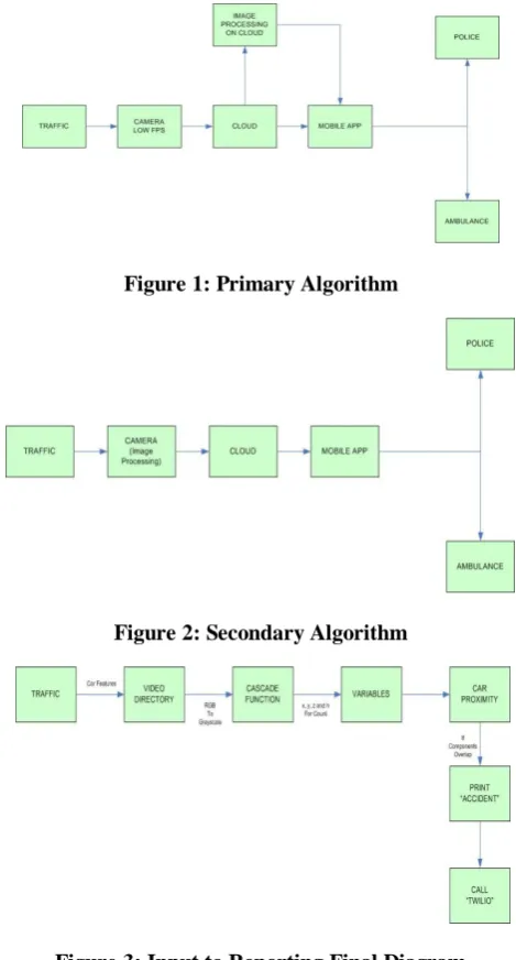
i. The ‘Car Features’ are extracted from the Database and are send to the Video Directory. Then the video directory is set ‘to be processed’.
ii. Reading the video which is present in the ‘Video Directory’ and converting the RGB video to Grayscale format in which it is easier to detect the moving vehicles.
iii. The grayscale video is now provided to the ‘Car Cascade Function’ which gives us x, y, z and h components of the cars in the video.
iv. Use the x, y, z, and h to count the vehicles and store the number in the variables.
v. Use these the stored components to calculate the car proximity for the cars in the video. vi. If the coordinates of any of the two cars overlap
print ‘Accident’ in the console then alert the GSM module which will send a text message which contains the Coordinates of the accident to the requested authorities which are Police and Ambulance so that they can arrive at the place as soon as possible.
[image:2.595.308.543.303.739.2]Since it was hard for us to have a live simulation set up at traffic signals, we initially applied our algorithms on online data sets. To have greater accuracy and application of the algorithm, we used toy cars to showcase our algorithm in a better manner. We took two toy cars and we came up with multiple angles of collision between both of them. We could manage to get the live detection of the accident. As soon as the accident occurs, we get a live notification in form of a message to the concerned authorities.
Figure 1: Primary Algorithm
Figure 2: Secondary Algorithm
IV. TESTS AND EVALUATION
[image:3.595.305.551.48.217.2]The working of the model works in several steps. The vehicles are detected and location is initialized. Arduino updates the location and writes it onto a file that is read by the accident detection sequence. Accidents are detected from the footage using a python code. When an accident occurs, it raises an alert and sends a text to the authorities along with the GPS coordinates of the incident.
Figure 4: Accident Detection and Reporting Algorithm
(A) Vehicle Detection
The following image shows the successful detection of
[image:3.595.50.291.171.370.2]vehicles in a feed footage. It is done using a Haar Cascade Function using OpenCV which converts the said video into greyscale and breaks it down frame by frame to detect any vehicles in each and every frame. Every detected vehicle is marked by a green rectangle.
Figure 6: Vehicle Detection
(B) Updation of GPS Coordinates
[image:3.595.305.550.339.514.2]On the hardware end of the project, we have an Arduino at the test spot which regularly updates the GPS coordinate location of the vehicles. It writes and overwrites the coordinate onto a file that is read by the detection algorithm for alerting authorities for medical aid.
Figure 7: Obtaining GPS Coordinates
(C) Accident Detection
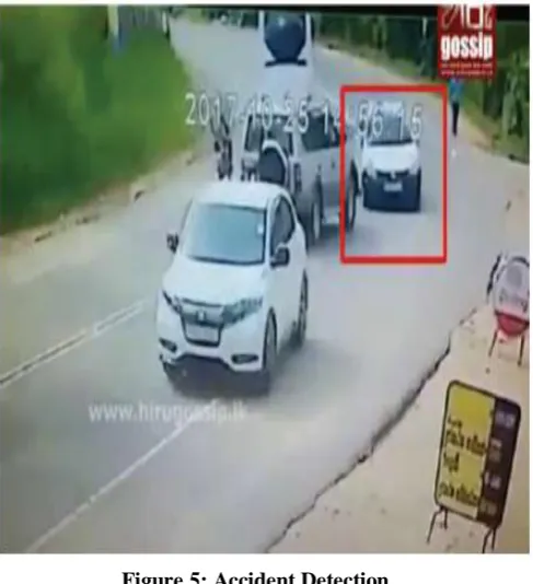
The image shows the ideal working of the accident identification by the system. The detected vehicles are simultaneously tested for proximity in between them. This is done by calculating the distance vectors of each vehicle from the camera point and also the angle of vision which helps the program to place the vehicles on a 3D frame. Based on the learnings of the provided dataset, the program is able to detect an accident as soon as it occurs and send an alert to the concerned authorities.
[image:3.595.50.294.448.715.2]Figure 8: Accident Detection in Indoor Simulation(Back Collision)
(D) Alerts
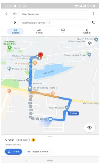
As soon as an accident has occurred, the program triggers a function which sends an SMS to the nearest hospital and police station. The numbers are fed into the system based on the location of the camera device. The SMS provides a Google Maps link which can help the ambulance reach the spot even faster. This also reduces the margin for error.
[image:4.595.49.296.50.229.2]Figure 9: Directions provided from Live Location to Accident Coordinates
Figure 10: SMS sent from on-site device V. CONCLUSION
We executed image processing so as to detect, record, and report traffic accidents at any given. We tested initially with created collisions of vehicles at different angles so as to create the data set, which acts similar to the video recordings of the vehicles travelling on the road. The proposed model is identifies accidents more effectively and then by informing the concerned authorities. The detection part also proved to be one of the best methods to detect such incidents with high precision. To build the prototype discussed into a real product, we need to make sure that the internet connectivity at the accident prone junction is proper and we need a high quality camera. Alternatively a cloud integrated camera system can be built where the camera would push low frames per second video on the cloud and services like the amazon web services, google firebase or windows azure can be employed for further computations. Thus, the low frame speed videos pushes from the street camera would be analysed through deep learning and image processing on the cloud externally. This would allow us to save capital from building camera with high processing power and with high frames per second specifications. Other features that can further be incorporated into the system to add to its social value include: wrong way detection, traffic prediction, capturing of vehicle number on law transgression and anomaly detection.
REFERENCES
[image:4.595.82.255.373.655.2]2. Kun-feng Wang, Xingwu Jia and Shuming Tang, "A survey of vision-based automatic incident detection technology," IEEE International Conference on Vehicular Electronics and Safety, 2005., Shaan'xi, 2005, pp. 290-295.
3. Qiang Shang, Derong Tan, Song Gao, and Linlin Feng, “A Hybrid Method for Traffic Incident Duration Prediction Using BOA-Optimized Random Forest Combined with Neighborhood Components Analysis,” Journal of Advanced Transportation, vol. 2019, Article ID 4202735, 11 pages, 2019.
4. T. S. Chouhan and R. S. Deshmukh, "Analysis of DSDV, OLSR and AODV Routing Protocols in VANETS Scenario: Using NS3," 2015 International Conference on Computational Intelligence and Communication Networks (CICN), Jabalpur, 2015, pp. 85-89. 5. Yong-Kul Ki, Jin-Woo Kim and Doo-Kwon Baik, "A Traffic Accident
Detection Model using Metadata Registry," Fourth International Conference on Software Engineering Research, Management and Applications (SERA'06), Seattle, WA, 2006, pp. 255-259.
AUTHORSPROFILE
Dhanamjayulu C is a faculty and a member of control and automation department in School of electrical engineering, Vellore Institute of Technology, Vellore, India. He has received the PhD degree in electronics engineering from Vellore Institute of Technology, Vellore, India, the M.Tech in control and instrumentation systems from Indian Institute of Technology, Madras, India. He is also an Assistant Professor (Senior) with the School of Electrical Engineering, Vellore Institute of Technology, Vellore, India. Since 2010, he has been a Assistant professor senior at Vellore Institute of Technology, Vellore, India. His research activities are in the area of multilevel inverters, power converters, and active power filters and power quality
Pavan Kumar G N is a student of B.Tech, E&I department of School of Electrical and Electronics Engineering at Vellore Institute of Engineering, India.
Prerna Sarkar is a student of B.Tech, EEE department of School of Electrical and Electronics Engineering at Vellore Institute of Engineering, India.
Ashwin Namboodiri is a student of B.Tech, E&I department of School of Electrical and Electronics Engineering at Vellore Institute of Engineering, India.
Yash Kant Varshneya is a student of B.Tech, E&I department of School of Electrical and Electronics Engineering at Vellore Institute of Engineering, India.
Priya Vyshnavi is a student of B.Tech, EEE department of School of Electrical and Electronics Engineering at Vellore Institute of Engineering, India.