Papers and Proceedings of the Royal Society of Tasmania, Volume 123, 1989 247
A TRANSECT STUDY OF THE SAND DUNE VEGETATION
AT BAKERS BEACH, TASMANIA
by M. A. Chladil and J. B. Kirkpatrick
(with three tables, five text-figures and three plates)
CHLADIL, M.A. & KIRKPATRICK, J.B., 1989 (31:x): A transect study of the sand dune vegetation at Bakers Beach, Tasmania. Pap. Proc. R. Soc. Tasm. 123: 247-256. https://doi.org/10.26749/rstpp.123.247
ISSN 0080-4703. Department of Geography and Environmental Studies, University of Tasmania, GPO Box 252C, Hobart, Tasmania, Australia 7001.
Vegetation zonation on coastal sand dunes at Bakers Beach consists of Spinifex hirsutus grassland, He/ichrysum paralium-Acacia sophorae heath and a complex of Acacia sophorae heath with Lomandra longifolia herbland, the latter community being concentrated in the swales. Melaleuca ericifolia swamp forest occupies the drainage line to the rear of the sand dunes. Although the two seaward zones and the swamp forest may be in equilibrium with the environmental complex, the vegetation on the main body of the dunes has been degraded from its original state by clearing and stock grazing and shows evidence of shifting from its present condition towards communities dominated by Leucopogon parviflorus and Banksia marginata. Eucalyptus viminalis open-forest may have occupied much of this dune system in the past. Floristic variation along a transect through the dunes is closely related to edaphic and topographic conditions, supporting models of soil-vegetation relationships on sand dune systems that have been developed elsewhere in southeastern Australia.
Key Words: coastal vegetation, sand dunes, Tasmania.
INTRODUCTION
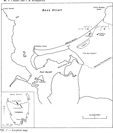
Some quantitative data are available on the vegeta tion of coastal sand dune sequences in southeastern Tasmania (Bowden & Kirkpatrick 1974, Brown & Bayley-Stark 1979, Kirkpatrick, in press) and southeastern Australia (Turner et al. 1962, Specht 1972, Ladd et al. 1976, Barson & Calder 1981, Kirkpatrick, in press) but none are available for northern Tasmania. Other Tasmanian coastal areas have also been described (Stephens & Cane 1939, Davis 1940, Kirkpatrick 1973, 1975, Brown 1980). As northern Tasmania was known to largely lack plant commumt1es and species such as Leptospermum laevigatum and Banksia integrifolia that characterise sand dune systems of the humid southeastern Australian mainland (Kirkpatrick, in press), and was also known to have beach sands which are considerably more calcareous than those of southeastern Tasmania (Davies 1978), it was thought worthwhile to document the vegetation of one of its largest systems of parallel dunes, or beach ridges (Davies 1978) at Bakers Beach in Asbestos Range National Park (fig. I). The study was conducted in May, August and September I 986. The pattern of variation in vegetation along a transect orthogonal to the beach is described, and the relationship between edaphic and topographic environmental variables and vegetation along this
transect is examined. The past and likely future of the vegetation of this sand dune system are dis cussed.
THE STUDY AREA
Bakers Beach (41 °08'S 146°38'E) faces Bass Strait on Tasmania's mid-northern coast at the mouth of the Port Sorell estuary (fig. I). The beach front is about 7 km long and has a dune system parallel to the beach front with a lagoon and wetlands behind. The beach is located within Asbestos Range National Park (4281 ha) which was proclaimed in 1976. Prior to proclamation, the Park was mostly a grazing property; the lagoon and wetlands had been drained for improved pasture and the whole area subject to recurrent fires for "green pick" and to wildfires. Following proclamation, grazing stock were removed and the (convict built) drains filled. As the lagoon filled, the native animal population rapidly expanded. A wildfire burnt much of the dune system in 1978. The vegetation is recovering from the fire in the face of heavy grazing pressure from European rabbit (Oryctolagus cuniculus), common wombat (Vombatus ursinus) and Bennetts wallaby (Macropus rufogriseus).
poinl Sorell
Bass Strait
Little Badger
Head
...Archers Knob
KILOMETRES
1
I
"'The Springlawn'"
Port Sorett
Q~~
Shell Islands~
Bass Strait
t
[image:2.484.59.433.127.567.2]FIG. 1 - Location map.
TABLE 1
Selected Average Climatic Data for Low Head, Tasmania (28 m a.s.l.)
J
F M A MJ
J
A S 0 N D YearRainfall (mm) 37 38 42 55 68 80 80 71 60 60 41 46 683
Maximum
temperature(DC) 20.0 20.4 19.1 16.8 14.3 12.3 11.7 12.1 13.2 14.6 16.6 18.5 15.8 Minimum
temperature(DC) 12.7 13.1 12.0 10.2 8.2 6.5 5.9 6.3 7.4 8.5 10.0 11.6 9.4
Sand dune vegetation at Bakers Beach, Tasmania 249
(NPWS) 1979). The nearest weather station is at Low Head 16 km to the east. The annual rainfall is likely to be in the range 650-750 mm, mostly falling in winter. Temperatures are mild, with a range at Low Head of 12.TC to 20°C in January and 5.9°C to 11.7°C in July. Selected data are presented in table 1 (Bureau of Meteorology 1979). The wind regime has close to a bimodal distri-bution: dry northwesterlies (mostly in summer) and moist southwesterlies (mostly in winter). The major fetch is to the west-northwest, making Bakers Beach a relatively high-energy part of the coast.
METHODS
At 25 sites located on dune ridges and swales along a surveyed transect placed orthogonally to the beach (fig. 1) the following data were collected: the percentage cover of all perceived higher plant species, moss and bare sand along 20 m line inter-cepts (Canfield 1941) laid along dune swales and ridges; soil horizon depth; pH (using a CSIRO soil-testing kit); Munsell colour; and depth of water table, where less than 2 m. Soils were collected for later analysis of CaC03, and organic matter
content.
The qualitative vegetation data were classified using the poly thetic divisive technique contained in the program TWINSPAN (Hill 1979) and were ordinated using de trended correspondence analysis (Hill & Gauch 1980). Product moment correlation
coefficients were used to test relationships between vegetation and environment. Swamp vegetation sites were excluded from some analyses.
Species nomenclature follows Curtis (1963, 1967), Curtis & Morris (1975) and Willis (1970) except where authorities are given at first mention. Structural nomenclature follows Kirkpatrick &
Harwood (1983) for wetland communities and Specht (1970) for other communities.
RESULTS AND DISCUSSION
Variation along the Transect
Calcareous sands undifferentiated to depth charac-terise the two foremost dunes (table 2), the second of which is the tallest in the whole series (12.5 m). On these two dunes vegetation changes from Cakile
ephemeral herbland at the rear of the beach to heavily-grazed Spinifex hirsutusopen-grassland on the small foredune to a rich mixture of composite shrubs, scramblers (Tetragonia implexieoma and
Rhagodia baecata) and Aeacia sophorae on the second large dune (fig. 2, pI. 1).
The smaller ridges and swales to the rear of the foredune system have been topdressed by cal-careous sands as a result of blowouts on the foredune. This narrow layer of calcareous sand is underlain by one, or sometimes two, weakly podsolised soil horizons. In this part of the dune system, swales are largely occupied by Pteridium
PLATE 1
PLATE 2
Ridges dominated byAcacia sophorae and swale dominated by Lomandra longifolia.
TABLE 2
Surface Soil Properties Along the Transect at Bakers Beach
Sample* CaC03 pH NaCI Organic content
% (ppm) %
-'~'~-~~~~---_.'~--~-'.,-_. ...
_
-DI 10.45 7.0 70 0.0
D2 12.36 7.0 14.5 0.0
D3 13.78 7.0 4 0.0
D4 6.75 7.0 14 0.0
D5 6.95 7.0 45 0.0
Rl 8.42 7.0 6.5 0.0
SI 9.21 7.0 11 0.0
R2 8.99 8.0 5.5 0.0
S2 7.33 7.0 6 0.0
R3 8.19 7.0 16 1.9
S3 6.37 7.0 0 0.0
R4 5.69 6.5 12 1.3
S4 4.22 7.0 4 0.5
R5 5.06 6.5 34.5 1.5
55 3.22 6.0 16.5 1.4
R6 4.45 6.0 18 1.0
S6 5.00 6.0 39.5 3.4
R7 3.34 6.0 22 1.5
57 3.18 6.0 7 3.7
R8 2.80 6.0 3.5 2.3
M 2.41 6.0 40 2.6
E 5.82 6.0 11 1.6
- - - -- - - _ . _ - - - - _ . _ - - - --. _ ~
Sand dune vegetation at Bakers Beach, Tasmania 25i
50
M088
Acacia sophorae
Lomandra longlfolla Pterldlum esculentum
%
COVER 50
1
~ ~
Sptnlfex hlrsutus .
=
=
50
1
iHellchrysum paralium _ • •
~"""
• •"---r---,.---~----~
100 -
i
iTetragon/a Implexlcoma
50~.
50
1
- - " " " - - - , - - - - , - - - , - - - - r - - - ,Rhagodlabaccata '.-~...,j.IIII
..
---'""""I'...- -...
----.----__.----_r---100-'Leucop"ogon parvlflorus
Hypochaerls redlceta Banks/a marglnata
"'e/a/euca erlclfolla
Topographic profile
%Vegetation cover
%CaCO
a
content of 80il%Organic content of 80il
METRES
PLATE 3
The rear of the sand dune system, the swamp and the stranded cliff.
esculentum, Lomandra longifolia, small herbs and bare sand, while the ridges have vegetation similar to that of the second foredune with scramblers among composite shrubs and 1-2 m tall spreading
Acacia sophorae (pI. 2).
The break between topdressed podsols and those without topdressing can be clearly perceived in the absence of scramblers and composite shrubs, in the presence of species such as Acaena echinata and
Pimelea humilisand in the increased cover of moss (fig. 2, pI. 2). The rear dunes have the same pattern of shrub dominance on ridges and herb dominance in swales as is evident for the topdressed area (pI. 3). They are bounded by a swale with a species-poor 10 m tallMelaleuca ericifolia swamp
forest to their rear. This forest abuts a quartzite cliff covered by scrub dominated by Casuarina stricta
on its lower slopes and heath on its upper slopes (pI. 3).
Vegetation-Environment Relationships
along the Transect
TWINS PAN classification clearly discriminated between the major vegetation units described above, and also between vegetation ridges and swales on the old sand at the rear of the sand dune system (table 3, fig. 3). The ordination scores on the first axis exhibit an exponential decline with
D1 D2 D3D4D5 R1S1R2 S2R3S3 R4 R5R6R7 S4S7 S5S6R8 M ESw1Sw2Sw3
pH 7 7 7 7 7 7 7 8 7 7 7 6.5 6.5 6 6 7 6 6 6 6 6 5.55.55.5 6
FOREDUNES NEW SAND OLD SAND SWAMP
Sand dune vegetation at Bakers Beach, 'hlsmania
253
TABLE 3
Percentage Frequency of Species by TWINS PAN Classification Groups
- - - , ..~
Species Colonisers New sand Old sand Swamp
(n=5) (n=7) (n=9) (ll=")
Spinifex hirsutus 100
Cakile edentula 20
Helichrysum paralhlm 60 86 11
Acacia sophoraI' 60 86 67
Tetragonia implexicoma 60 71
Rhagodia baccata 60 71
Acaena novae-zelandiae 20
Oxalis corniculata 20 lOa 67 25
Fumariasp, 20 86 33
Leucopogon parviflorus 20 71 56 50
Stipa jlavescens 20 29
Carpobrotus rossii 40 86 78
Pteridium esculentum lOa 100 50
Lepidosperma gladiatum 29
Dichondra repens 86 56 25
Graminaesp, 57 22
Senecio minimus 57
Lomandra longifolia 71 lOa 50
Clematis microphylla 14 22
Danthonia setacea 14 78
Hypochaeris radicata* 100
Coprosma quadrifida 22
Acaena echinata 78 25
Pimelea humilis 78 25
Luzulasp, 56
Acrotriche serrulata 44 25
Geranium sessiliflorum 89 25
Cymbonotus lawsonianus II
Plantago varia 33
Helichrysum scorpioides II
Airasp, 56 25
Banksia marginata 22
Rumex acetosella* 44 25
Dichelachne crinita II
Melaleuca ericifolia II 100
Scleranthus biflorus II
Carexsp, II
Centauriumsp,* II
Glycine clandestina II
Exocarpus strictus II
Leptospermum lanigerum 25
Acacia verticillata 50
Helichrysum dendroideum 25
Rubus parvifolius 25
Cassytha melantha 25
Bursaria spinosa 25
Moss sp, lOa lao 25
Fungi sp, 20 14 50
Litter 14 56
Lichen sp, 14 II
150
FIG. 5 - Relationship between ordination values on axis two and height above mean high tide mark.
especially given the sharp break in species distribution patterns at the new sand--old sand boundary in the ridge/swale complex. The propor-tion of bare ground, and thus potentially mobile sand, may be important in limiting species establishment (Ranwell 1972: 51). The correlation coefficient between sand cover and the cumulative species number (r=--0.843 p<0.01) is consistent with this hypothesis.
The second axis of the ordination is most closely related to topography, as indicated by height above the mean high-water mark. All sites in the ridge/ swale complex above 5.6 m have ordination scores in excess of 51, while all such sites below 5.6 m have ordination scores less than this figure (fig. 5). Height above sea level is probably related to moisture availability in the upper part of the soil. This hypothesis is supported by the relationship between moss cover and height above sea level in the ridge/swale complex (r = --0.720, p <0.001). Consistent moisture availability and occasional waterlogged conditions are almost certainly associated with theM. ericifoliaswamp forest, the only place where the water table is reached within 2m.
Vegetation Change
Buried soil horizons and dune morphology indicate that the sand dune system was dynamic even before European settlement. The vegetation undoubtedly responded to such changes and to past variations in Aboriginal land use.
There is no direct evidence of the nature of the Bakers Beach dune vegetation before 1800. The remains of dead Eucalyptus viminalis, and some living individuals of Casuarina stricta, Bursaria spinosa and Banksia marginata indicate that communities dominated by trees could potentially occupy most of the ridge/swale complex. The use of the ridge/swale complex for stock grazing seems to have inhibited regeneration of these tree species, and to have turned most of the area into a sparse herbland dominated by Lomandra longifolia and
Pteridium esculentum as reported elsewhere (Brown & Bayley-Stark 1979, Brown 1980, Dickinson& Kirkpatrick 1986). Cessation of stock grazing was followed by fuel accumulation and a fire which may have led to a further retreat of the eucalypts. Fire-stimulated germination of seeds of
Acacia sophorae over most of the complex thus gave rise to its present dominance. However,
A. sophoraeis a short-lived species which relies on disturbance for its regeneration (Hazard& Parsons ,
"
,R' ,R4 R', ,R' 'R' , "100 200 300
DISTANCE FROM HIGH WATER MARK(m)
L---.--r---.:,--.---,---r~.
4
L
'"
,,'
.57
R.s_.,,
,R_7_ - , - - , - - ,5 6
HEIGHT ABOVE MEAN HIGH WATER(m)
~100
"'
w '3"'
> Z o ;::"'
~ 50a: o
t
UJ w '3"'
> Z 50 o ;::"'
z 15 a: oFIG. 4 - Relationship between ordination scores on axis one and distance from the high water mark.
Sand dune vegetation at Bakers Beach, Tasmania 255
1977). In the absence of another fire or mechanical disturbance through dune movement, it is likely to be replaced as a dominant on the ridge/ swale complex by Leucopogon parviflorus, a bird dispersed species capable of continuous regeneration without disturbance (Hazard &
Parsons 1977). Iffires recur on the dune system, the nature of the resulting vegetation will be highly dependent on fire regime and the interaction of fire with grazing (ef. Brown 1980). In the early part of the nineteenth century, many of the coastal dune systems that are now covered by scrub or herbland were covered by scattered trees and tall shrubs over native tussock grass (Plomley 1966, Stockton 1982). Where tree species survive at Bakers Beach, such vegetation could be induced by low intensity burning at a frequency sufficient to prevent successful establishment of species such asAcacia sophorae, which rely on regeneration from seed
rather than vegetative recovery. Occasional severe fires, however, will encourage the latter species and prevent growth of tree seedlings.
The large herbivore density on the dunes is such
that Spinifex hirsutus open-grassland on the
fore-dune is cropped to lawn height by wombats, and scat densities are high throughout the ridge/swale complex. The potential influence of these herbi-vores on tree and shrub seedling regeneration is hard to predict, although it is known that the effects of herbivores can be dramatically increased by other sources of disturbance such as fire (Leigh &
Holgate J979, Dickinson & Kirkpatrick J986). Heavy grazing pressure may favour herbs and grasses rather than shrubs (Dickinson &
Kirkpatrick J986). There is little likelihood that even severe fire will dramatically reduce herbivore numbers, as the main focus of grazing activity is on fire-resistant former paddocks to the rear of the dunes.
Context and Conservation Importance
Although most of the Bakers Beach sand dune vegetation is in a Jess pristine state than that of Rheban Spit (Bowden & Kirkpatrick 1974) or the Maria Island isthmus (Brown & Bayley-Stark J979), enough elements of the original vegetation remain to show that, with a few minor exceptions, zonation is similar. Bakers Beach, unlike the other two systems, has not been invaded by marram grass
(Ammophila arenaria), and the native sand-binder
is Spinifex hirsutus rather than Festuca littoralis.
The swamps in southeastern Tasmania are dominated by Melaleuca squarrosa rather than
M. ericifolia. However, the three areas lack the
Victorian element of coastal sand dune species present in the far northeast and northwest of mainland Tasmania (Kirkpatrick, in press).
The reservation status of the vegetation complex found on coastal sand dune systems is relatively poor, because of the demand for such areas for agricultural and recreational (shack) development. Thus, the Bakers Beach area, despite its present degraded state, is an important area for long-term conservation of sand dune vegetation and its associated fauna. It is a valuable area for location of permanent monitoring plots and exclosure plots, to record vegetation change and assess the impact of fauna in an apparently dynamic system.
ACKNOWLEDGEMENTS
Data collection and analysis was a joint project of Helen Cray, Steven Cleaves, Tina Duncan, Jenny Hough, Alan MacFayden, Ray McKendrick, John Megalos, Mike Kennan, Vicki Lee Thomas and the authors. Denis Charlesworth assisted with laboratory analysis. Dr Guus van der Geer drew the figures.
REFERENCES
BARSON, M.M. & CALDER, D.M., 1981: The vegetation of the Victorian coast. Proc. R. Soc. Viet. 92: 4-65. BOWDEN, A.R. & KIRKPATRICK, LB., 1974: The
vegetation of Rheban Spit, Tasmania. Pap. Proc. R. Soc. Tasm. 108: 199-210.
BROWN, M.L, 1980: The vegetation of the Mt Cameron West Aboriginal Site. Pap. Proc. R. Soc. Tasm. ]14: 2]-34.
BROWN, M.L & BAYLEY-STARK, J.H., 1979: Vegetation of Maria Island. Wildl. Div. Tech. Rep. 79/1. Tasm. NPWS: 99 pp.
BUREAU OF METEOROl.OGY, 1979: CLIMATIC SURVEY
TASMANIA, REGION 3 NORTHERN. Department of
Science and the Environment, Canberra: 64 pp. CANFIELD, R., ] 941: Application of the line interception
method in sampling range vegetation .
.r.
Forest. 39:388-394.
CURTIS, W.M., 1963: THE STUDENTS FLORA OF
TASMANIA. PART II. Government Printer, Hobart.
CURTIS, W.M., 1967: THE STUDENTS FLORA OF TASMANIA, PART III. Government Printer, Hobart. CURTIS, W.M. & MORRIS, D.!., 1975: THE STUDENTS
FLORA OF TASMANIA, PART I. 2nd edition,
Government Printer, Hobart.
DA VIES, LL., 1978: Beach sand and wave energy in Tasmania. In Davies, J.L. & Williams, M.AJ. (Eds):
LANDFORM EVOLUTION IN AUSTRALASIA.Oxford
DA VIS. C, 1940: Preliminary survey of the vegetation
near New Harbour, Tasmania. Pap. Proc. R. Soc.
Tasm. 1940: 1-90.
DlcKINsm, K.J.M. & KIRKPATRICK, LB., 1986: The
impact of grazing pressure in clearfelled, burned and undi sturbed eucalypt forest. Vegetatio 66: 133-136.
HAZAR-D, L & PARSONS, R.F., 1977: Size-class analysis
of coastal scrub and woodland, Western Port, South
Australiil. Ausi.1. Ecol. 2: 187-198.
HILL, MO., 1979: TWINSPAN - A FORTRAN
PROGRAM FOR ARRANGING MULTI-VARIATE
DATA IN AN ORDERED TWO-WAY TABLE BY
CLASS1PICATION OF THE INDIVIDUALS AND
AnRIBUTES. Section of Ecology and Systematics,
Cornell University, Ithaca.
HILL, MO. & GAUCH, H.G., 1980: Detrended
correspondence analysis: an improved ordination
technique. Vegelalio 42: 47-58.
KIRKPATRICK, J.B., 1973: The vegetation of Sloping Island, Tasmania. Vici. Nal. 90: 313-321.
KIRKPATRICK, J.B., 1975: Phytosociological analysis of the vegetation of Lagoon Beach, Tasmania. Pap. Proc.
R. Soc. Tasm. 109: 53--63.
KIRKPATRICK, J.B., in press: Dry coastal vegetation in southeastern Australia. In Mauri, E. van der (Ed.): DRY
COASTAL ECOSYSTEMS. Elsevier, Amsterdam.
KIRKPATRICK, J.B. & HARWOOD, C.E., 1983: Plant
communities of Tasmanian wetlands. Ausl. 1. Bol. 31:
437--451.
LAOD, P.G., LADIGES, P.Y. & CALDER, D.M., 1976:
IDENTIFICATION OF THE LAND-BASED
VEGETATION SURROUNDING THE GIPPSLAND
LAKES AND LAKE TYERS. Ministry for Conservation,
Victoria.
LEIGH, J.H. & HOLGATE, M.D., 1979: The responses of
the understorey of forests and woodlands of the
Southern Tablelands to grazing and burning. AUSI. J.
Ecol. 4(1): 25-45.
NATIONAL PARKS& WILDLIFE SERVICE, 1979: The impact
of proposed pine plantations on wildlife in the West
Tamar region, Tasmania. Unpub!. Rep. Tasm. NPWS. PLUMLEY, NJ.B., 1966: FRIENDLY MISSION. THE
TASMANIAN JOURNALS AND PAPERS OF GEORGE
AUGUSTUS ROBINSON 1829-1834. Tasmanian
Historical Research Association, Hobart.
RANWELL, D.S., 1972: ECOLOGY OF SALT MARSHES
AND SAND DUNES. Chapman and Hall, London.
SPECHT, R.L., 1970: Vegetation. In Leeper, G.W. (Ed.):
THE AUSTRALiAN ENVIRONMENT, 4th edition.
CSIRO and Melbourne University Press, Melbourne: 44-67.
SPECHT, R.L., 1972: THE VEGETATION OF SOUTH
AUSTRALIA. 2nd edition, Government Printer,
Adelaide.
STEPHENS, e.G. & CANE, R.F., 1939: The soils and
general ecology of the north-east coastal region of Tasmania. Pap. Proc. R. Soc. Tasm. 1938: 201-208.
STOCKTON, J., 1982: Fires by the seaside: historic
vegetation changes in northwestern Tasmania. Pap.
Proc. R. Soc. Tasm. 116: 53-66.
TURNER, J.S., CARR, S.G.M. & BIRD, E.C.F., 1962: The
dune succession at Corner Inlet, Victoria. Proc. R. Soc.
Viet. 75: 17-33.
WILLIS, J.H., 1970: A HANDBOOK TO PLANTS IN
VICTORIA, VOLUME I. 2nd edition, Melbourne
University Press, Melbourne.