PAPERS A~D PROCEEDINGS OF TII:E: ROYAL SOCIETY OF TASMANIA, VOLUME lOU
PLEISTOCENE DEPOSITS AT PARANGANA DAMSITE
IN THE MERSEY VALLEY
By
S. J. PATERSON
Hydro-Electric Commission, Tasmania
(With 3 text figures and two plates.)
ABSTRACT
Pleistocene glaeial and periglacial deposits filling a channel 200'
+
deep and 200' wide at Parangana Damsite in the Mersey Valley are deseribed. It is suggested that the site is the location of a terminal zone.INTRODUCTION
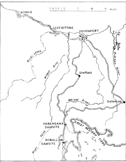
The following information is the result of further investigation of Parangana Damsite (Figure 1) in the gorge tract of the Mer&ey River t mile below the Fisher River Junction. The results of a pre-liminary investigation were given in Volume 99 of this journal.
At the damsite (Figure 2, Plates I and ID the Mersey River is superimposed and flows from south to north transverse to the structural trend. The gorge has been cut in vertically to near vertically foliated Precambrian Fisher Group quartzite, schist, phyllite and slate. It has a broad upper profile and a narrow buried U-shaped central channel 200'
+
deep and 200' wide. The profile of the channel has been defined approximately by drilling and seismic survey. The average core recovery in the channel fill has ranged from 40% to 30% and these results have been achieved by using triple tube core barrels, bottom dischal'ge bits and mud as the drilling fiuid.CHANNEL FILLING
Details of the channel filling are shown on Figure 3. The bottom of the .channel has not been located, but the bulk of the channel from SL940' to SL1125'
085') is filled with what is considered to be peri-glacial solifluction material. This is overlain by glacial drift, which has a maximum thickness of 50'.
The periglaeial solifluction material is unstrati-fied and consists of angular rock fragments in a yellowish to reddish-brown sandy clay to clayey sand matrix. Along the dam axis, where the valley walls are formed by quartzite, the angular rock fragments (Drill Holes 5773, 5774, 5781, 5782, 5783, 5784 and 5791) consists mostly of pebbles, cobbles a.nd boulders (up to 18" diameter) of quartzite, with pebbles 1" and less predominating. A few angular pebbles of schist and rounded pebbles o.f weathered basalt and dolerite are also present. Downstream, where the valley sides are formed by repetitions of
147
quartzite and schist, the proportion of schist pebbles <Drill Holes 5767 and 5771) is markedly higher. In both areas the ratio of fragments to matrix averages about 60:40. On the left abutment a pocket of periglacial solifluction material up to 90' wide and 30' deep occurs within the glacial drift
<Drill Holes 5774, 5783 and 5791).
The position of this quartzite fragment and clay deposit below and within glacial drift suggests deposition close in time and place to a glacial environment, whereas the angular shape and the predominance of quartzite and schist fragments indicates local origin with little transport. Coupled with the similarity of the content of the deposit with the composition of the immediately adjacent valley wall this is indicative of a periglacial solifluc-tion origin. The drill core has been examined by Stephens (Qlaeial Geomorphologist, Queens Uni-versity, Belfast) who agrees with these conclusions. The mass movements are considered to have taken place when the glacier was in the near vicinity, as a result of thawing of the surface layer in the summer months while the ground below remained frozen. That the material accumulated and filled the channel suggests that it dammed it at a time when the flow of water was greatly reduced, when precipitation remained in the upper reaches of the valley in the form of snow and ice.
A distinctive reddish-brown clay occurs in the core from Drill Holes 5'768 (32' -114'), 5772
020'-125') and 5784 (80'-97'). It is missing in Drill Hole 5782 which lies between Drill Holes 5768 and 5784. In this hole the clay is replaeed by peri-glacial solifluction material containing a sand band (87'-91'), suggesting erosion of the elay. The clay may be the result of a soliftuction slide of basaltic material from Emu Plains, or it may be a till, but most probably it was deposited in a lake dammed by a solifluction slide.
148 PLEISTOCKNR _, DLPOSITS AT PARANGANA . , DA:tvl SITE
5 4 3 2 i 0
[image:2.511.57.473.75.608.2]!SOO
1200
pf:f
!/ 00
J. P;\TB:RSON
Sotiftuctton & Fluvial
& /or Fluviogl.aciol Material
Seismic Velocity Boundary
13500 Seismic Velocity
Fisher Group
IJ':ft-J
Quartzite & Schist Concealed Boundary..
Drill Hote ~~-- Foliationl 0 0 so 0 100 200 300 400 FEET
~~-~-~~~~~~~fi···-~=-~~·~--~~~~~~----~
...
~p€f
Fw" 2. --Geologieal Map and Section of Parangana Dan1site.
150 PLEISTOCENE DlM'OST'IS AT PARANGANA DAM SITE
GLACIAL DRIFT
The layer of glacial drift that covers the pori-glacial solifluction material extends onto both banks of the river, where it is in turn overlain by talus. The maximum thickness is about 50' in the channel section, but a 20' thick deposit occurs on the right bank 150' above river level, and a 40' thick deposit occurs on the left bank 130' above river level.
An adit 110' long was driven into the deposit on the left bank and in this up to 70% of the material consists of pebbles, cobbles and boulders, coated with clay, silt and sand. The material is toughly
compacted, uncemented to weakly cemented,
unstratified and heterogeneous, and the greater part has been derived from dolerite, with basalt, quartzite and schist contributing minor amounts. Boulders of dolerite and basalt up to 3' in diameter occur and these a.re sub-rounded to rounded, whereas the boulders of quartzite and schist range up to 10' diameter and are angula.r. The qua,rtzite and schist boulders are locally deriv;ed, possibly superglacial till, but the dolerite boulders have been transported from the Central Plateau. The fmer material is weathered yellowish-brown in the adit, but little matrix was recovered from the drill cores. Bands of medium grained quartz, schist and dolerite sand were located by Drill Hole 5772 09' -19'6" and 29'-34') and the drilling mud was lost in Drill Hole 5773 at 29'-40'. It reappeared at the base of the slope 110' downstream.
Subsequent river erosion has removed any topo-graphic evidence of the nature of the deposit at Parangana Damsite. Nevertheless the drift appears to have been deposited near the limit of gladation, for immediately downstream interlocking spurs
replace the straight broad with truncated
spurs that exists upstream of damsi:te. The
situation suggests terminal moraine conditions, such that both lodgment and ablation till might be expected. A degree of lithification corresponding to a weak tillite occurred in Drill Holes 5769 ( 47'-48'6"), 5770 (27'-31') and 5771 (16'-20') just off the northern edge of the Geological Plan (fig. 2) sug-gesting deposition as a lodgment till under a con-siderable weight of ice. By 'Comparison the glacial drift in the adit is. only a toughly compacted till, and
the proportion of coarse material suggests some
by meltwaters and perhaps deposition as till. The presence of a pocket of peri-glacial solifluction material within the till suggests a retreat and readvance of the glacier. A high proportion of rounded pebbles and boulders occur in the till in the adit; this ma.y be the result .of
weathering of the dolerite in the source area, the distance o.f transport (up to 20 miles), and rework-ing in part by water durrework-ing transport.
The degree of weathering of the glacial drift at Parangana is unusually deep, for in the adit the rna;trix is weathered yellowish-brown at a depth of 85' below the surface, which is 45' below the base of the talus. Deep weathering also occurs at the Fisher River .Junction where dolerite boulders are almost completely decomposed at a depth of 15'. By contrast the till in the Rowallan Damsite borrow are::;. 7 miles upstream is fresh a few feet from the surface. Weathered material may have been trans-ported by ice to the Parangana area from the upper
valley, but the difference in degree of weathering may also be indicative of an age difference between the two deposits. The glaeial drift at Pa.rangana may be older than that at Rowallan Damsite.
TALUS
Talus obscures the greater part of the right abutment and all of the left abutment, and talus fans extend almost to plateau level on both sides of the prominent quartzite cliffs that lie above the left abutment.
The deposits have a maximum thickness of about 35' (Drill Hole 5719) and slopes of up to 30'. Three test pits were dug on the left abutment and these indicate an upper few feet of loose rock fragments overlaying lightly compacted, tough, bony talus consisting of angular rock fragments set in a sandy clay matrix. The junction of the talus with the underlying drift is a free draining zone coated with black carbonaceous material.
The upper loose layer is moving under the exist-ing environment but the thick compacted layer is considered to be the product of a periglacial environment and to have formed by solifluction <headl as the glacier retreated from the site. It is stable under the existing environment.
GEOMORP.HIC IHS'l'ORY
The Mersey River took its present course (Spry, 1958! after extrusion of the Tertiary basalts, Hnd at the beginning of the Pleistocene a valley about 1600' deep was in existence. The nature of the basal deposits in the central ehannel is not known, but Lhe profile indicated by drilling and seismic suggests some modification of the valley by action. The central channel was filled by a series of solifluction slides, probably while a glacier remained in the near vicinity. During this
of reduced river flow the slides offcot>1i"••lu dammed the river permitting
of 32' Hole 5768) of clay. The bands
present are thought to be fluvial or fiuvioglacial deposits laid down as the dams were overtopped. The presence of a pocl,et. of solifluction material within the glacial drift suggests that at least two g·lacial advances occurred, at which time the solifluction deposits were protected from erosion by ground freezing. The location appears to have been near the site of a terminal zone.
ACKNOWU:DG:M:ENTS
The author is indebted to the Hydro-Electric Commission for permission to publish the informa-tion contained in this paper.
Thanks are due to G. E. A. Hale and G. Rawlings of the Commission, N. Stephens of Queens versity, Belfast and E. Derbyshire of Monash Uni-versity for helful discussion.
REFERENCES
PATEHSON, S. J., 1965.--·-Pleistocene Drift in thq- Mersey and FoYth Valleys---Probability of T'wa Glacial Stages. Pap,
Roy. Soc. Tasm.., 99, pp. 115-124.
I
I
p€fI
litOOI
i iCOO p£t
!
900
' ·
-S. J. PATERSON
p€f
pet
QUATERNARY
Talus
GraiJels - Scroll Bank Deposits
~9IJ Drift - Tilt and FLL;vioglo~.:tol
Deposits ~~ Peoiglaciol Sol!flwr:tion Matenol
& Flw11ol &/or Fluviaglcxiul
Sand ·Clay=::::: Grovel.,:,"'
PRECAMBRIAN
Fisher Group
L:£0~:=J Quortzite
Se-ismic- Velocity Boundary
FIG. ~) --Details of the channel filling at Parangana Darnsite.
[image:5.511.21.472.154.470.2]F.P.152
PAPJiJRS ANn PJWCF.EDING~ OI<' THB l{OYAL SoctETY OP TAsMAl'..:IA. VOJ.UMF. 100