International Journal of Innovative Technology and Exploring Engineering (IJITEE) ISSN: 2278-3075,Volume-8 Issue-6, April, 2019
Abstract: In social network worldwide there are a lot of people having twitter accounts. Every new and old user trying to create a new account in twitter for his own purposes like they can follow and tweet to the celebrity and the popular persons but some users giving the fake details in their profile like country, place, and locations. It may happen for fake data information and tweets, followers and unwanted messages can be posted on Twitter. Here using the geographical tracking location system with the help of longitude and latitude of geo-location mapping system. So users' can register an account with the current location only, if anyone trying to create the duplicate location that user information will be blocked and the details of latitude and longitude information can be sent to the admin with the current location of duplicate users'. It proposes to validate its effectiveness through the experiments.
Index Terms: geo-location, twitter, real-time, classification
I. INTRODUCTION
A social network is the most trending way on the internet surfing and also the twitter is one of the ways on trending in the Social network. It is used to any kind of activities like updates the current news, tweets about the popularity person and politician etc. A huge number of user interests with these kinds of peoples all interest to search and following the kind of information. Online networking is more and more being used as a section of the logical cluster as a key wellspring data to assist comprehend various regular social events and this has incited the advance of an intensive form of machine information mining devices that may separate learning from web-based social networking for each constant investigations. API is free to use with the help of Google API.Google-API is a key for google-map to locate the geo-location. It will locate the users' current location, for example, geocoding and geo-tagging are utilized to activate extra social fluctuation. User agreed area information or geo-location approach can enable online networks to interface and arrange users with surrounding public or appearance that suit their interests.
Geo-location on online-based social network
Revised Manuscript Received on April 07, 2019.
Kishore Kumar K School of Information Technology and Engineering (SITE), Vellore Institute of Technology (VIT), Vellore, India
S. Meenatchi Assistant Professor (SG) in the Department of School of Information Technology and Engineering.
Prasanna santhanam, Associate Professor at School of Information Technology and Engineering, Vellore Institute of Technology, Vellore, India.
G Gunasekaran, Assistant Professor (Selection Grade) in School of Information Technology and Engineering, Vellore, India.
Vijayan Ramaraj, Associate Professor School of Information Technology and Engineering, VIT-Vellore Institute of Technology, Vellore, India.
administration can be IP-based for portable social media, noticed location information or smartphone tracking can set up location-based approach to develop and upgrade social networking.
II. RELATEDWORKS
[1] Web-based social network is enormously prevalent, with billions of users' crosswise over the different stage. The investigation of social media has taken into account further investigation into questions postured by PC researchers, social researchers, furthermore, others. Online network posts labeled with the area have given intends to specialists to perform significantly more profound examination into their information.While area data takes into account rich knowledge of social media information, not very many posts are expressly labeled with geographic data. [2] This idea depends on the certainty that people for the most part act uniquely in contrast to the fakes, along these lines, identifying this conduct will prompt the noteworthy of the mock profiles. Here they are using dataset also, social network online service sites, for example, Twitter turns the users' interest in the world and their social media with interpersonal interaction has influenced their life. This prevalence in person to person communication has prompted distinctive issues counting the likelihood of presenting off base data to their users' through phony data which results in the spread of pernicious substance. This circumstance can result in a gigantic harm in this present reality to the general public. [3] Social network of Twitter can be watched when clients progressively repost joins they have gotten from others. In this project depict how geographic data separated from social falls can be abused to move forward storing of sight and soundless in a Content Delivery Network. Exploit the way that social falls can engender in a geologically restricted zone to perceive whether a thing is spreading locally or internationally. This illuminates store substitution strategies, which use this data to guarantee that substance significant to a course is kept near the clients who might be occupied with it. consolidates social cooperation information with geographic data. Track social falls on youtube connect on Twitter, what's more, form a proof-of-idea geographic model of a sensible dispersed Content Delivery Network. our execution assessment demonstrates that can enhance store hits with regard to store strategies without geographic and social data.[4] Web-based coverage tool for subject coverage apart from collection data in social media.
Real-Time Classification of Twitter Trends using
Support Vector Machine with Location Tracking
The system is a time period dashboard for presidency agencies assigned to observe communities throughout disaster events. However, the success of community-based computing systems like e-Bayanihan is measured by continuous participation from its users. applicable motivation has relevancy reassuring continuous participation. This presents a replacement methodology of planning a community-based computing atmosphere that uses motivation analysis in crucial the foremost probable crucial package options that may maximize continuous user participation. The options to be evaluated were extracted from the event team. [5] Observing and dissecting this made and chronic consumer created substance will yield terribly vital information, empowering shoppers and associations to secure vital learning. this text provides an outline of systems for occasion discovery from Twitter streams. These procedures opt for discovering true events that unfold over area and time. instead of normal media, occasion discovery from Twitter streams postures new difficulties. Twitter streams contain loads of aimless messages and contaminated substance, that adversely influence the identification execution. what is a lot of, typical content mining ways don't seem to be applicable, on account of the short length of tweets, the large range of writing system and grammar blunders, and {also the} continuous utilization of casual also, homogenized accent. occasion discovery ways exhibited in writing address these problems by adjusting procedures from totally different fields to the individuality of Twitter. this text orders these procedures as per the occasion compose, recognition assignment, and identification technique and talks regarding typically used highlights. At long last, it options the necessity for individuals benchmarks to assess the execution of varied location approaches and totally different highlights. [6] Geo-location expectation is essential to geospatial applications like restricted inquiry and near occasion identification. Predominately, web-based social networking geo-location models rely on full content data, as well as traditional words with no geospatial activity and boisterous strings conceivably hampering forecast and prompting slower/lot memory-serious models. during this project, center on discovering space characteristic words by means that of highlight alternative, and increase whether or not the lessened list of capabilities helps geo-location exactitude. our outcomes demonstrate that a knowledge acquire magnitude relation primarily based approach outperforms totally different techniques at the determination, beating leading edge geo-location forecast techniques in exactitude and decreasing the mean and middle of expectation mistake take away by severally, on associate degree open dataset. to boot, detail thoughts of expectation certainty, and exhibit that execution is considerably higher in things wherever the model is additional bound, hanging associate degree exchange off amongst exactitude and scope. At long last, the distinguished uncover native idiom contrasts, that can be conceivably valuable for word specialists. [7] Geo-located web-based social network information gives a capable wellspring of data about the place and territorial human conduct. Since minimal web-based social networking information is geo-location commented on, derivation procedures serve a fundamental part to increase the volume of explained information. one
noteworthy class of conjecture approaches has depended on the informal community of Twitter, where the areas of a client's companions fill in as proof for that user's area. While numerous such derivation strategies have been as of late proposed, really know minimal about their relative execution, with the measure of ground truth information changing in the vicinity of the system, the span of the informal community fluctuating by four requests of greatness, and little institutionalization in assessment measurements.
[8] Current cell phones models are all prepared to do constantly running information accumulation programming to total various sensor readings. These gadgets would thus be able to give a dedicated record of a client's versatility. By gathering, GPS arranges investigation of human action designs customarily depends on the consistent following of client area. Approach the issue of action design revelation from another point of view which is quickly picking up consideration. Rather than currently testing expanding volumes of sensor information, Investigate the participatory detecting capability of various portable interpersonal organizations, on which clients frequently uncover data about their area and the scenes they visit. In this project, Introduce computerized strategies for separating, conglomerating, and preparing consolidated social organizing follows with the objective of extricating portrayals of routinely happening client exercises, which allude to as "users' schedules". Discoveries in view of two restricted information sets about a solitary pool of clients: the previous contains open geo-tagged Twitter messages, the last Foursquare registration that give us significant scene data about the areas watch. Break down and consolidate the two datasets to feature their properties and show how the rising highlights can improve our comprehension of clients' day by day plan. At long last, assess more, examine the capability of routine portrayals for anticipating future users' movement and area.
[9] All through the investigation, interviewees attached Google Latitude to their social networks of advances. They most usually referred to Facebook, Twitter, moment detachments, messaging, and logbooks. This project reports preparatory consequences of a progressing ethnographic investigation of individuals' dispositions towards and reception of Google Latitude, an area following innovation for versatile gadgets. With a specific end goal to comprehend boundaries to reception, members incorporate the two clients and non-clients of Latitude, and those whose use has dropped off. The report centers around how members see Latitude to be adroitly arranged inside the environment of long range
interpersonal communication and correspondence
advancements. Prior take a shot at client demeanors concerning area following accentuated potential security concerns. In exploration more over recognized protection concerns, however also a few other more notable pressures, for example, appropriation patterns, social conformance, gathering of people administration, and data sifting.
International Journal of Innovative Technology and Exploring Engineering (IJITEE) ISSN: 2278-3075,Volume-8 Issue-6, April, 2019
messages can profit an assortment of downstream applications. Be that as it may, these geo-location systems are commonly assessed without consideration to how changes in time affect geo-location. Since various individuals, in various areas compose messages at various circumstances, these variables can fundamentally shift the execution of a geo-location framework after some time. They illustrate patterned fleeting consequences for geo-location indecent in Twitter, and in addition quick drops as test information moves past the day and age of preparing information. Here demonstrate that transient float can effectively be countered with even humble on the web display refreshes. [11] Protection in the news appears to be inevitable; a general concern as to meddling and inescapability of on the web following, publicizing, and checking has gotten the general population consideration. For instance, worries over the exercises of social organizing destinations and sponsors, for example, facebook raise issues of secrecy and following in day to day life. Diverse nations have distinctive security administrative models. These models affect the points of view and laws encompassing web protection. In any case, little is thought about how viable the administrative models are with regards to constraining web-based following and promoting action. In this project, propose a strategy for researching following conduct by breaking down treats and HTTP asks for from perusing sessions beginning in various nations. Gather internet surfing information from visits to top sites in different nations that use extraordinary administrative models. That there are noteworthy contrasts in following action between various nations utilizing a few measurements. Additionally, recommend different approaches to expand this examination which may yield a total portrayal of following from a worldwide viewpoint.
[12] Different GPS-based following frameworks have been effectively conveyed and used in different applications. what's more, vehicle area distinguishing proof, and in course direction. As of late, frameworks that incorporate GPS and GSM advances with Google earth to give constant information have additionally been proposed. Be that as it may, for inside and shut conditions GPS frameworks miss the mark and it winds up hard to gain the fundamental satellites for exact position calculation. The application would give the capacity to separate intrigued geo-graphical zone into various subzones. Utilizing the separation from numerous satellites, the GPS collector can triangulate its present area. Basically, the point at which every one of the circles cross is the area of the recipient. At least three satellites is expected to decide a two-dimensional area (scope and longitude). Correspondences from extra satellites enable a GPS recipient to decide extra positional data, for example, height. A GPS collector won't restrict itself to just four satellites. All in all as the quantity of satellites from which the beneficiary can get information expands, so does the precision of the area.
III. PROPOSED REAL-TIME CLASSIFICATION OF TWITTER TRENDS USING SUPPORT VECTOR MACHINE.
A capability to order tweets by space unceasingly is very important for applications misusing on internet social networking update as social sensors that found out track points and sorting out concerning space explicit inclined themes, developing occasions and breaking news. Explicit
utilizations of endless, nation level tweet geolocation framework incorporate nation explicit drifting purpose recognition or following feeling towards a subject matter separated by a nation. To the simplest of our insight, our work is that the 1st to manage worldwide tweet in any language. Utilizing simply those highlights introduce the substance of a tweet and its connected information. If the users give the mock place and location, that user can't sign-up the page and the fake user will be blocked. That user tried location to be sent to the blocked user in the admin page. So the mock users' will be blocked and admin can view and they can take action for this kind of activity.
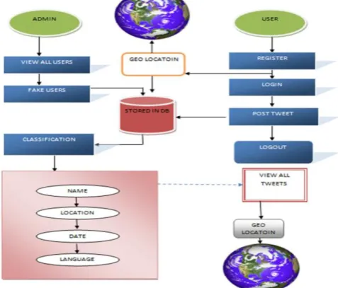
[image:3.595.311.550.493.696.2]In this proposed framework Admin is the main role and it is the part of the management. Admin can view here show the user given all wrong registrations and that person current latitude and longitude sent to admin side and they can filter tweets like a name-based filter, location-based filter, date based filter and language-based filter.Admin can log in with his or her own login username and password. Login also is the basic rule to be followed in this process and it will directly go to the admin login page. Then the admin can access all the control and process given by the functions.Blocked user module is used for viewing the fake users directly by admin. Most of the users are creating mock profiles, providing duplicate address and location on his or her profile then they are posting unwanted posts and tweets. So here use geolocation tracking system to track the current location. There is a sign-up page and all the sign-up details provided include the location tracking system. Here only show the user given all wrong registrations and that person current latitude and longitude also show there. If the users give the mock place and location, that user can't sign-up the page and the fake user will be blocked. That user tried location to be sent to the blocked user in the admin page. So the mock users' will be blocked and admin can view and they can take action for this kind of activity.
As shown in Fig.1 view all user module is providing for all the twitter users' can be show here and admin can view what kind of users' are there and their profile activities. The name-based filter is used for finding the name wise filter. There is a lot of users having a different name so here it can classify by the given name and show in the filter. The language-based filter is used to filter the way of users' language and it can classify the users' language and it will be shown here. Then the admin can view what kind of tweets they posted. Date Based filter is used to filter the date wise tweets. It can classify when and what time they tweeted will be shown here. The location-based filter is used to filter the location-based tweets. If you give some a place and some people tweeted in that particular place. It will be classified and show here otherwise not. Here specified for the user and it is a role of Twitter users for a social network. A large number of people are using twitter social network.
Register page is used to sign-up for the new Twitter user and the basic details to be followed. Include the location tracking system also used here, so it will locate the current location of the sign-up place, you can sign up for the current location only. Otherwise, if u give a wrong location you can't sign-up and it will be blocked then the information send to admin. Here login page is used to user login. If the user is valid then only it will be going to user home page otherwise it can't go to that login. The user can view all Twitter users’ tweets with location, date and time in his or her login page and it will update all tweets post. People are all connected to the Twitter social network and they share a tweet via his or her User login page they can give tweet and post it. Logout option also provided for the twitter users safely log out their twitter account and the twitter is directly going to the Twitter home page.
Classification Algorithm proposed to arrange the tweet users’ into their area, name, location, date, time, tweet content. SVM is an advanced machine learning calculation which can be utilized for both arrangement and relapse challenges. Be that as it may, it is for the most part utilized as a part of grouping issues. In this calculation, plot every datum thing as a point in n-dimensional space. Where n is number of highlights you have with the estimation of each element being the estimation of a specific facilitate. At that point perform a grouping by finding the hyperplane that separate the two classes exceptionally well
Fig. 2. SVM
There are three hyper-planes having they are (A, B & C) as in Fig.2. It shows the hyperplane to classifying blue stars and red circle. Here a thumb rules to show the right hyper-plane, it classify the hyper lane B has accurately done this operation.
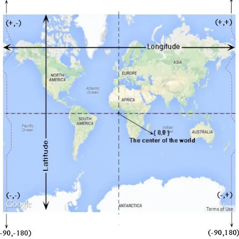
[image:4.595.310.551.228.468.2]Here Location Verification Technique using google map to locate the current location of latitude and longitude with the help of geo-location. Google map provides a Google API to access the google map, this API embedded with this project. So the location tracking is made on these latitude and longitude approach as shown in Fig. 3, this method embedded in program via the URL method of URL encoder. URL encoder is ways to access the google map API address and latitude-longitude approach exactly locate the current location of tweets users. By using the Location Verification algorithm can block the users who are all using the fake location. And proposed work is very effective compared to the Existing method.
Fig. 3. Location verification technique
Area on Twitter can be utilized to recognize and taking part in harassing of other online clients by means of social network, Additionally Twitter has been known to be a decent stage for identifying the flare-ups of sicknesses and cataclysmic events. The capacity to precisely deduce the area of influenced clients can spare lives and help in critical situation. In the event that the users’ furnishing the area which doesn't coordinate with the present area then the users’ record will be blocked. To achieve this proposed Location check procedure.
[image:4.595.52.288.589.726.2] [image:4.595.327.530.626.716.2]International Journal of Innovative Technology and Exploring Engineering (IJITEE) ISSN: 2278-3075,Volume-8 Issue-6, April, 2019
Visualize that you are in some place on Earth with three satellites in the Fig. 4. In the event that you know how far away you are from A satellite. At that point you know you should be found some place on the red circle. In the event that you do likewise for B and C satellites, you can work out your area by observing where the three circles converge. This is exactly what your GPS beneficiary does, in spite of the fact that it utilizes covering circles instead of those circles.
[image:5.595.305.548.49.239.2]User can view their name and tweets activity with place, date and time. They can also tweet messages in the social network of twitter as in Fig. 5.
Fig. 5. User Sign-Up
User can view their name and tweets activity with place, date and time. They can also tweet messages in the social network of twitter as in Fig. 6.
Fig. 6. User Tweet
[image:5.595.46.293.171.348.2]Admin can view Twitter users profile details to be executed in all users’ as in Fig. 7. It can view all the Twitter users’ with all details and all data to be stored in database.
Fig. 7. All Users View
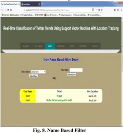
[image:5.595.304.557.299.572.2]Name-based filter is used to classify the tweets through name wise and it will be executed in admin side for viewing the Twitter users’ location as in Fig. 8.
Fig. 8. Name Based Filter
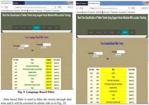
[image:5.595.48.291.394.592.2]Fig. 9. Language Based Filter
[image:6.595.49.556.48.785.2]Date based filter is used to filter the tweets through date wise and it will be executed in admin side as in Fig. 10.
Fig. 10. Date Based Filter
[image:6.595.294.553.53.416.2] [image:6.595.48.546.400.743.2]Location-based filter is used to filter the tweets through Location wise and it will be executed in admin side as in Fig. 11.
Fig. 11. Date Based Filter
Location tracking is used tolocate the users location through the google map with the help of google APIand it will be executed in admin side as in Fig.12.
International Journal of Innovative Technology and Exploring Engineering (IJITEE) ISSN: 2278-3075,Volume-8 Issue-6, April, 2019
IV. RESULTS AND DISCUSSION
[image:7.595.47.296.189.323.2]Classification Algorithm proposed to arrange the tweet users’ into their area, name, location, date, time, tweet content. SVM is an advanced machine learning calculation which can be utilized for both arrangement and relapse challenges. Be that as it may, it is for the most part utilized as a part of grouping issues. In this calculation, plot every datum thing as a point in n-dimensional space. Where n is number of highlights you have with the estimation of each element being the estimation of a specific facilitate.
Fig. 13. CNN vs SVM
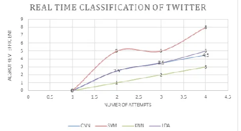
[image:7.595.309.547.236.388.2]Comparing here for twitter classification of the algorithm like CNN, SVM, KNN, LDA as in Fig. 14.. Classification means a large number of data classifies into a single term. SVM Classification Algorithm proposed to arrange the tweet users’ into their area, name, location, date, time, tweet content. training-set and testing set. Training- set means the data already classified into the algorithm. Testing-set means data are all ready to classify into the algorithm which has a great work for twitter classification. KNN classification algorithm proposed to use the model of vector space to classify the data. It calculates the similarity of data is near from the neighbor. CNN process that is able to learn specific invariant task features hierarchically. The layers and a top fully connected to layer with associated weights rely on and pooling layers as well. This structure allows the convolutional neural network to take advantage of the two-dimensional structure of the input data. LDA perspective of the most extreme back gauge of class individuals. LDA works when every perception of the free factors is persistent. We right off the bat got the mean and difference from each class of preparing the set, then connected LDA condition to every datum purpose of testing-set. The class with the most to be selected as the class for the testing point.
Fig. 14. Classification of CNN,SVM.KNN and LDA
Comparing the location tracking for live location and
login location, both are comparing the linear way of live location average as in Fig. 15. Logging in is typically wont to enter a particular page on the websites. Once the user is logged in, the login token could also be wont to track what actions the user has taken whereas connected to the location. work out could also be performed expressly by the user taking some actions, like getting into the acceptable command, or clicking a web site link labeled in and of itself. It can even be done implicitly, like by the user powering off his or her digital computer, closing an internet browser window, departure an internet web site, or not refreshing an internet page at intervals an outlined time. GPS following the gadget fits into the vehicle and catches the GPS area data separated from other vehicle data in general to a server. Scope and longitude method is utilizing here to the live area framework.
Fig. 15. Location Tracking
In the above Fig. 14 used to locate the current location of Twitter users' and it can track to the live location of Twitter users'. Nowadays technologies advanced in wireless location tracking, it can continuously track the user location and the location tracking is used with the help of Google-API. Google-API is a key for Google-map to locate the geo-location. It will locate the users' current location, for example, geocoding and geo-tagging are utilized to activate extra social fluctuation. User agreed area information or geo-location approach can enable online networks to interface and arrange users with surrounding public or appearance that suit their interests. In the above Fig.13 used to classify the algorithm for twitter tweets like the name-based filter, location-based filter, language-based filter and date based filter. Classification algorithm proposed to arrange the tweet users’ into their area, name, location, date, time, tweet content. training-set and testing set. Training-set means the data already classified into the algorithm. Testing-set means data are all ready to classify into the algorithm which has a great work for twitter classification.
V. CONCLUSION
In this paper using Java as a language. Netbeans with HTML and JavaScript for output presentation. In project insight, this is the primary investigation execute out a thorough inspection of the value of tweet inalienable highlights to consequently surmise the nation of the starting point of tweets in a continuous situation from a worldwide stream of tweets written in
[image:7.595.48.293.617.750.2]Author-1 Photo Previously attempts to geo-locate global tweets tended to
restrict their collection to tweets this means that they did not consider the entire stream, but only a set of cities, which assumes prior pre-processing. Classify new tweets with a classifier trained on older tweets. So here use geolocation tracking system to track the current location. There is a sign-up page and all the sign-up details provided include the location tracking system. Here only show the user given all wrong registrations and that person current latitude and longitude also show there. If the users give the mock place and location, that user can't sign-up the page and the fake user will be blocked. That user tried location to be sent to the blocked user in the admin page. So the mock users' will be blocked and admin can view and they can take action for this kind of activity. Experiments and analysis reveal insights that can be used effectively to build an application that classifies tweets by country in real time. In the future when the users come online in social media, they can track via map location continuously each and every users' live movement in social media like what's up, facebook twitter etc. Now, most of the mobiles are having fingerprint sensor so social media authentication systems can be changed into a biometric system.
REFERENCES
1. Erşahin, Buket, Özlem Aktaş, Deniz Kılınç, and Ceyhun Akyol. "Twitter
fake account detection." In 2017 International Conference on Computer
Science and Engineering (UBMK), pp. 388-392. IEEE, Oct 2017.
2. Mehrotra, Ashish, Mallidi Sarreddy, and Sanjay Singh. "Detection of fake Twitter followers using graph centrality measures." In 2016 2nd International Conference on Contemporary Computing and Informatics
(IC3I), pp. 499-504. IEEE, Dec 2016.
3. Ajao, Oluwaseun, Jun Hong, and Weiru Liu. "A survey of location inference techniques on Twitter." Journal of Information
Science,vol. 41,No. 6,pp. 855-864,2015.
4. Amigó, Enrique, Jorge Carrillo De Albornoz, Irina Chugur, Adolfo Corujo, Julio Gonzalo, Tamara Martín, Edgar Meij, Maarten De Rijke, and Damiano Spina. "Overview of replab 2013: Evaluating online reputation monitoring systems." In International conference of the cross-language
evaluation forum for european languages, pp. 333-352. Springer, Berlin,
Heidelberg,Sept 2013.
5. Atefeh, Farzindar, and Wael Khreich. "A survey of techniques for event detection in twitter." Computational Intelligence,vol. 31,no. 1,pp. 132-16,Feb 2015.
6. Han, Bo, Paul Cook, and Timothy Baldwin. "Geolocation prediction in social media data by finding location indicative words." Proceedings of
COLING 2012, pp. 1045-1062,2012.
7. Bollen, Johan, Huina Mao, and Alberto Pepe. "Modeling public mood and emotion: Twitter sentiment and socio-economic phenomena." In Fifth
International AAAI Conference on Weblogs and Social Media, pp.
450-453,Jul 2011.
8. Jurgens, David, Tyler Finethy, James McCorriston, Yi Tian Xu, and Derek Ruths. "Geolocation prediction in twitter using social networks: A critical analysis and review of current practice." In Ninth International AAAI
Conference on Web and Social Media,pp. 188-197,Apr 2015.
9. Morstatter, Fred, Huiji Gao, and Huan Liu. "Discovering Location Information in Social Media." IEEE Data Eng. Bull,vol. 38.,no. 2,pp. 4-13,2015.
10.Li, Muyuan, Haojin Zhu, Zhaoyu Gao, Si Chen, Le Yu, Shangqian Hu, and Kui Ren. "All your location are belong to us: Breaking mobile social networks for automated user location tracking." In Proceedings of the 15th ACM international symposium on Mobile ad hoc networking and
computing, pp. 43-52. ACM, Aug 2014.
11.Scellato, Salvatore, Cecilia Mascolo, Mirco Musolesi, and Jon Crowcroft. "Track globally, deliver locally: improving content delivery networks by tracking geographic social cascades." In Proceedings of the 20th
international conference on World wide web, pp. 457-466. ACM, March
2011.
12. Sayyadi, Hassan, Matthew Hurst, and Alexey Maykov. "Event detection and tracking in social streams." In Third International AAAI Conference
on Weblogs and Social Media , March2009.
13. Pianese, Fabio, Xueli An, Fahim Kawsar, and Hiroki Ishizuka. "Discovering and predicting user routines by differential analysis of social network traces." In 2013 IEEE 14th International Symposium on" A World of Wireless, Mobile and Multimedia Networks"(WoWMoM), pp. 1-9. IEEE, June 2013.
14. Tamura, Keiichi, and Hajime Kitakami. "Detecting location-based enumerating bursts in georeferenced micro-posts." In 2013 Second IIAI
International Conference on Advanced Applied Informatics, pp.
389-394. IEEE, Aug 2013.
15. Page, Xinru, and Alfred Kobsa. "The circles of latitude: Adoption and usage of location tracking in online social networking." In 2009
International Conference on Computational Science and Engineering,
vol. 4, pp. 1027-1030. IEEE, Aug 2009.
16. Fruchter, Nathaniel, Hsin Miao, Scott Stevenson, and Rebecca Balebako. "Variations in tracking in relation to geographic location." arXiv preprint
arXiv:1506.04103,June 2015.
17. Kinage, Radhika, Jyotshna Kumari, Purva Zalke, and Meenal Kulkarni. "Mobile tracking application." International Journal of Innovative
Research in Science, Engineering and Technology,vol. 2, no. 3,pp.
617-623,March 2013.
18. Kadibagil, Mahesh, and H. S. Guruprasad. "Position Detection and Tracking System. " IRACST-International Journal of Computer Science and Information Technology & Security (IJCSITS),vol. 4,no. 3,pp. 19,June 2014.
19. Shakhakarmi, Niraj, and Dhadesugoor R. Vaman. "Real time position location & tracking (PL&T) using prediction filter and integrated zone finding in OFDM channel." WSEAS Transactions on
Communications,vol. 11,no. 7,July 2012.
20. Doran, Derek, Swapna Gokhale, and Aldo Dagnino. "Accurate local estimation of geo-coordinates for social media posts." arXiv preprint
arXiv:1410.4616,Oct 2014.
21. Zubiaga, Arkaitz, Damiano Spina, Raquel Martínez, and Víctor Fresno. "Real‐time classification of twitter trends." Journal of the Association for
Information Science and Technology,vol. 66, no. 3,pp. 462-473, March
2015.
22. Mislove, Alan, Sune Lehmann, Yong-Yeol Ahn, Jukka-Pekka Onnela, and J. Niels Rosenquist. "Understanding the demographics of twitter users."
In Fifth international AAAI conference on weblogs and social media,Jul
2011.
23. Lampos, Vasileios, Nikolaos Aletras, Jens K. Geyti, Bin Zou, and Ingemar J. Cox. "Inferring the socioeconomic status of social media users based on behaviour and language." In European Conference on Information
Retrieval, pp. 689-695. Springer, Cham, March 2016.
24. Graham, Mark, Scott A. Hale, and Devin Gaffney. "Where in the world are you? Geolocation and language identification in Twitter." The
Professional Geographer,vol. 66,no. 4,pp. 568-578, March 2014
25. Dredze, Mark, Miles Osborne, and Prabhanjan Kambadur. "Geolocation for twitter: Timing matters." In Proceedings of the 2016 Conference of the North American Chapter of the Association for Computational
Linguistics: Human Language Technologies, pp. 1064-1069. 2016.
AUTHORSPROFILE
International Journal of Innovative Technology and Exploring Engineering (IJITEE) ISSN: 2278-3075,Volume-8 Issue-6, April, 2019
Author-2 Photo
Author-3 Photo
Author-4 Photo
Author-5 Photo
G Gunasekaran is an Assistant Professor (Selection Grade) in School of Information Technology and Engineering, Vellore, India. He holds a B.E (CSE), M.Tech.(IT), and Ph.D. in the field of computer graphics and visualization techniques. His areas of interests include computer graphics, computer visualization techniques, digital image processing, multimedia computing, Unified Modeling Language and multimedia communication networks. He is a life member of the Computer Society of India (CSI) and Indian Society for Technical Education (ISTE). He has published the number of papers in reputed international journals and international conferences
Prasanna santhanam is working as Associate Professor at School of Information Technology and Engineering, Vellore Institute of Technology, Vellore,India. He received his Ph.D in Computer Science and Engineering from VIT.He graduated in Computer Science and Engineering from University of Madras, India and Postgraduate in Computer Science & Engineering from Anna university, India. He produced a number of national and international research articles in reputed journals and conferences. His research Interest involves Soft computing, Data mining, Block chain Technology and Machine Learning.
S. Meenatchi was awarded an honour in Bachelor of Engineering in Computer Science and Engineering specialisation in 2004. She was also awarded the honour in Master of Engineering in Computer Science and Engineering specialisation in 2006. She is working as an Assistant Professor (SG) in the Department of School of Information Technology and Engineering. She has published and presented many national and international journals and conferences. Her current areas of research activities include wireless sensor networks and network security. She is a life member in professional bodies like CSI..