This is a repository copy of Tectonic variation and structural evolution of the West Greenland continental margin.
White Rose Research Online URL for this paper: http://eprints.whiterose.ac.uk/85531/
Version: Accepted Version
Article:
Alsulami, S, Paton, DA and Cornwell, DG (2015) Tectonic variation and structural evolution of the West Greenland continental margin. AAPG Bulletin, 99 (9). 1689 - 1711. ISSN 0149-1423
https://doi.org/10.1306/03021514023
[email protected] https://eprints.whiterose.ac.uk/ Reuse
Unless indicated otherwise, fulltext items are protected by copyright with all rights reserved. The copyright exception in section 29 of the Copyright, Designs and Patents Act 1988 allows the making of a single copy solely for the purpose of non-commercial research or private study within the limits of fair dealing. The publisher or other rights-holder may allow further reproduction and re-use of this version - refer to the White Rose Research Online record for this item. Where records identify the publisher as the copyright holder, users can verify any specific terms of use on the publisher’s website.
Takedown
If you consider content in White Rose Research Online to be in breach of UK law, please notify us by
Tectonic Variation and Structural Evolution of the West Greenland Continental 1
Margin 2
3
S. Alsulami*, D. A. Paton*, D. G., Cornwell**
4
5
* Basin Structure Group, Institute of Applied Geosciences, School of Earth and Environment,
6
University of Leeds, Leeds, UK
7
**School of Geosciences, University of Aberdeen, King's College, Aberdeen, UK
8
9
Abstract 10
Due to its geographic extent of over 2500 km, the West Greenland margin provides a much
11
understudied example of a divergent continental margin, both with respect to hydrocarbon
12
exploration and academic studies. A seismic interpretation study of representative 2D
13
reflection profiles from the Labrador Sea, Davis Strait and Baffin Bay was undertaken to
14
identify sedimentary and structural components to elucidate the tectonic development of the
15
margin. Nine horizons were interpreted from six representative seismic lines in the area.
16
Margin-scale tectono-stratigraphy was derived from isochron maps, the geometry of
17
mappable faults and their associated stratal architecture.
18
19
Rifting began in Early to Late Cretaceous at c.145 -130 Ma, which was followed by two
20
pulses of volcanism in Eocene and Palaeocene ages. The transition to the drift stage includes
21
a typical subsidence phase but also erosion, uplift and deposition of Neogene postrift
22
packages. The shift in the position of depocentres in the Davis Strait and the Labrador Sea
23
during Palaeocene and Miocene times is evidence for structural modification of the basin
24
bounding faults. Drift stage deformation suggests a possible anticlockwise rotation in the
25
orientation of the spreading axis in Baffin Bay culminating in an ultraslow seafloor
26
spreading.
28
Seafloor spreading on the West Greenland margin started in the south at 70 Ma in the
29
Labrador Sea and propagated northward into the Baffin Bay by 60 Ma. Prospective petroleum
30
systems include thick Cretaceous age strata, with structural traps provided by grabens and
31
inversion structures. Our structural model provides insight into margin that is highly variable
32
in its structural configuration, further modified by other processes such as magma-assisted
33
rifting which may result in elevated regional heat flow which has considerable impact on
34
hydrocarbon maturation. Further constraining the implications of heat flow associated with
35
volcanic activities in comparison to that associated with lithospheric stretching will be critical
36
in future exploration.
37
38
Keywords: Seismic Interpretation, Tectonic, Basin Architectures, West Greenland, 39
rifting, magmatism 40
41
1.0 Introduction 42
Although there has been considerable interest, over a number of decades, in the evolution of
43
sedimentary basins associated with lithospheric stretching (e.g. McKenzie, 1978; Wernicke,
44
1985; Lister, 1986), recent studies have made significant advances in our understanding of
45
the processes involved. These studies have greatly expanded our understanding on the
46
variability of margins, in particular: the differences between volcanic and non-volcanic
47
margins (e.g. Reston and Perez-Gussinye, 2007; Franke, 2013); the role of depth dependent
48
stretching and multiple rift stages (e.g. Huismans & Beaumont, 2011; Soares et al., 2012);
49
and the influence of mantle plumes (White and McKenzie, 1989; Clift and Turner, 1995;
50
Corti, 2009; Lundin and Doré, 2011). These studies commonly focus on portions of margins,
51
or their equivalents on the conjugate margins. The aim of this study is to consider the lateral
variability of a single margin. We chose the West Greenland Margin because of the interplay
53
amongst a number of the key factors including: the presence of a mantle plume; the existence
54
of volcanic and non-volcanic areas on the margin; and changes in extension orientations.
55
Furthermore, the absence of salt enables us to understand margin architecture without the
56
limitations of either sub-salt imaging or salt tectonics.
57
58
The West Greenland Margin includes the Labrador Sea, Davis Strait and Baffin Bay (Figure
59
1). The margin is considered to have formed by the northward propagation of continental
60
rifting and seafloor spreading associated with the breakup of North America from Europe
61
during the Late Cretaceous and Early Paleocene periods (Balkwill et al., 1990; Chalmers,
62
1991, 2000, 2012; Chalmers and Pulvertaft, 2001; Chalmers et al., 1993; Nielsen et al., 2002;
63
Roest and Srivastava, 1989; Rowley and Lottes, 1988; Schenk, 2011).
64
65
The aim of this study is to consider the interplay amongst processes involved along an entire
66
margin during lithospheric rifting and drifting. We describe the basin development along the
67
West Greenland continental margin and consider the implication of this on hydrocarbon
68
exploration. By doing so, we quantify the overall basin fill and architecture during the
69
different phases of basin growth. We demonstrate that the timing of initiation and cessation
70
of rifting together with the duration of sea floor spreading are critical to improving the
71
evolutionary models for the West Greenland margin.
72
73
1.1 Tectonic and Geological settings of the West Greenland basin 74
The earliest rifting event probably occurred in the Early Cretaceous (c.145 -130 Ma) or Late
75
Jurassic periods (Schenk, 2011; Harrison et al., 1999). A second rifting event of Late
Cretaceous and Early Palaeogene age culminated in thermal subsidence and subsequent
77
passive margin sedimentation at ~ 60 Ma (Dam et al., 2000).
78
79
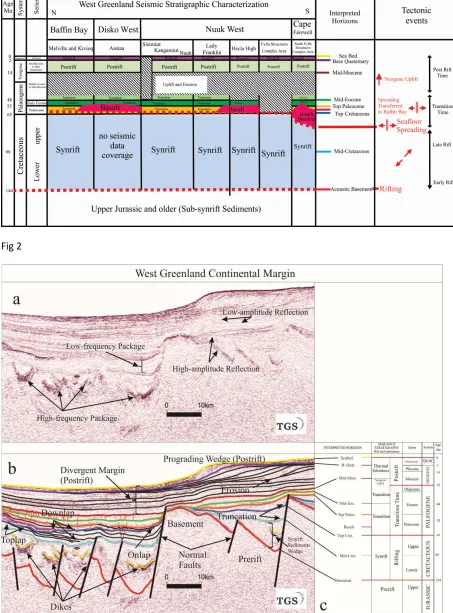
The Early Cretaceous rifting event is evidenced by deposition of clastics rocks in half grabens
80
and graben basins, such as the Kitsissut and Appat sequences (Chalmers and Pulvertaft,
81
2001). Sedimentary facies within this area includes alluvial fan, fluvial, fan-delta, deltaic and
82
shallow lacustrine sandstones and mudstones of the Kome and Atane Formations from
83
Nuussuaq basin (Balkwill et al., 1990; Chalmers and Pulvertaft, 2001; Dam et al., 2000;
84
Figure 2).
85
86
A Late Cretaceous unconformity separates deltaic deposits of the upper Albian Atane
87
Formation from fully marine deposits of the lower Campanian Itilli formation (Dam et al.,
88
2000). This Campanian Formation is equivalent to the marine deposits at Fylla Structure
89
Complex Area (FSCA), which is overlain by Kangeq Formation offshore West Greenland.
90
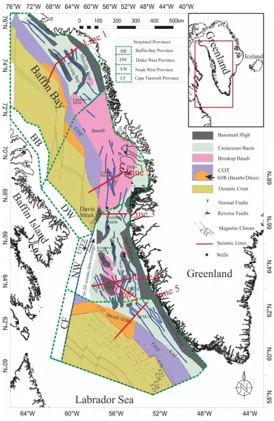
The Kangeq seismic sequences in West Greenland basins were probably deposited into
91
thermally subsiding basins (Chalmers et al., 1993; Chalmers and Pulvertaft 2001). The oldest
92
Mesozoic clastics rocks in the Baffin Bay region are Aptian to lower Albian sandstones of the
93
Quqaluit Formation, described by (Burden and Langille, 1990; Figure 2).
94
95
The Aptian-Albian mudstones of the upper Bjarni Formation on the Canadian Labrador shelf
96
are equivalent to the Appat Formation of Greenland. Similarly, the lower Bjarni Formation is
97
equivalent to the Kitsissut Formation of West Greenland (Chalmers et al. 1993, 2012). An
98
unconformity is present between the Cretaceous and Early Paleocene mudstones
(Nøhr-99
Hansen and Dam, 1997). Early Palaeocene mudstones were deposited above the Kangeq
100
Formation (Chalmers and Pulvertaft 2001).The onset of the second rifting event took place in
the middle of Paleocene (61 Ma) and was probably associated with seafloor spreading along
102
the West Greenland margin (Oakey and Chalmers, 2012). Extrusion of plateau basalts in both
103
offshore and onshore West Greenland took place in the Late Paleocene and Eocene and is
104
overlain by the fluvio-deltaic and marine deposits of Early Palaeogene age (Chalmers, 2012).
105
Offshore basalts drilled in the Hellefisk-1 and Nukik-2 wells have been interpreted in the
106
Hecla and Maniitsoq Highs (Chalmers et al., 1993, Rolle, 1985). Basalt layers in the southern
107
part of Baffin Bay represent the northernmost extension of the volcanic rocks found in the
108
Davis Strait and were possibly expanded equivalents of sea-floor spreading in Baffin Bay
109
(Whittaker, 1997; Rolle, 1985).
110
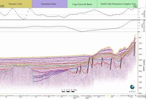
111
The Labrador Sea and Baffin Bay regions are connected by the Ungava Transform Fault
112
Zone (UTFZ) in the Davis Strait area (Figure 1). The (UTFZ) is characterized by complex
113
structures that were initially extensional. These structures were subsequently affected by both
114
transtension and transpression processes as the (UTFZ) evolved into a transform zone
115
(Skaarup et al., 2006; Sørensen, 2006). A Mid-Eocene unconformity was then developed
116
(Nøhr-Hansen and Dam, 1997) as a result of strike slip movement across the margin as well
117
as the Ikermiut flower structure (Chalmers et al., 1999).
118
119
From Mid-Miocene time, the West Greenland basins subsided without further obvious
120
evidence of tectonism, until Late Neogene times (Chalmers and Pulvertaft 2001; Green et al.,
121
2011). Strata of largely fine-medium grained sandstones of slope and fan were deposited as
122
as a result of the second postrift subsidence phase (Dalhoff et al., 2003; Schenk, 2011)
123
124
Neogene uplift in the central part of the West Greenland margin is recorded by 2-3 km uplift
125
in the Nuussuaq basin (Chalmers, 2000, Chalmers and Pulvertaft, 2001). Offshore evidence
on seismic can be seen in the uplift of the eastern Sisimiut basin (Dalhoff et al., 2003). In the
127
northwest end of Baffin Bay channel erosion is observed which is probably related to
128
Neogene uplift in the Jones Sound, southern Nares Strait and Lancaster Sound (Harrison et
129
al., 2011). The cause of Neogene uplift is still unknown. Although, subsidence analysis of
130
the margin reveals that Neogene uplift is unrelated to subsidence in offshore areas (McGregor
131
et al., 2012).
132
133
2.0 Materials and methods 134
Hydrocarbon exploration started in the Arctic region in the Late sixties with the collection of
135
gravity, magnetic, seismic and drilled borehole data. During the last 50 years existing
136
information has been substantially enriched by a series of completed 3D seismic surveys and
137
a significant amount of 2D seismic data. No major hydrocarbon discoveries, however, have
138
yet been made. Access to ~ 65,000 km of 2D processed and stacked seismic reflection data
139
was provided by the Geological Survey of Denmark and Greenland (GEUS) and the
TGS-140
NOPEC Geophysical Company (TGS) for this study. In addition, information from seven
141
published wells (Dalhoff et al., 2003) was used to create synthetic seismograms to tie well
142
data with intersecting seismic sections. The well ties were used to constrain both the age and
143
the lithology of the interpreted horizons. Since the wells are located farther from the seismic
144
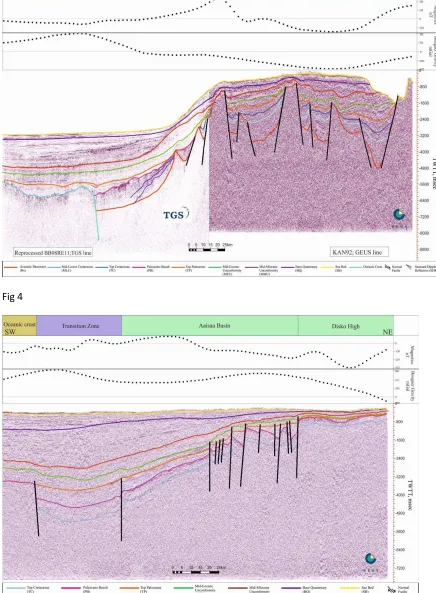
lines, extrapolation of the stratigraphic interpretation away from the wells was carried out by
145
following key stratigraphic horizons where possible (Sørensen, 2006).
146
147
A seismic-stratigraphic approach was used (Figure 3) to interpret the seismic data (Badley,
148
1985). Reflection terminations (e.g. onlap, down lap, erosional truncation) were used to
149
identify major sequence boundaries /unconformities on seismic sections. Reflection packages
150
were categorised as prerift, synrift, and postrift (Figure 3). Furthermore, seismic facies used
to discriminate megasequences include high amplitude reflections, continuity, frequency
152
variation and lap geometries (e.g. Mitchum Jr et al., 1977).
153
154
Faults were manually mapped from seismic reflection then displayed as lines in map-view
155
(Figure 1). Even with relatively large spacing between 2D seismic lines (8 km in Nuuk West
156
Province, 50 km in Cape Farewell, and 20 to 25 km in Disko West and Baffin Bay
157
respectively), it was possible to recognize and link major faults based on their geometries, dip
158
direction and the amount of displacement. Multiple lines were used to connect the faults in
159
order to create fault array maps and constrain the geological sense of regional faults trends
160
along the margin.
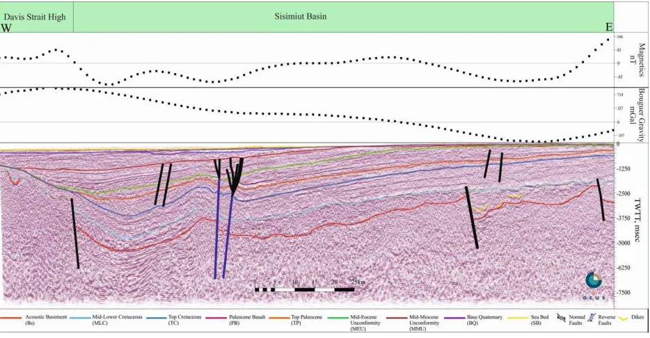
161
162
Having correlated the key seismic reflections across the basins, surfaces were generated that
163
accounted for picked faults and areas of erosion or non-deposition. Two way travel time
164
(TWTT) thickness maps were used to establish 1) relative stratigraphic thickness trends, 2)
165
zones affected by faulting, and 3) the overall basin architecture.
166
167
3.0 Tectonostratigraphy 168
The nine horizons interpreted include Sea Bed (SB); base Quaternary (BQ); Mid-Miocene
169
Unconformity (MMU); Mid-Eocene Unconformity (MEU); Top Palaeocene (TP); Palaeocene
170
Basalt (PB); Top Cretaceous (TC): Mid-Lower Cretaceous (MLC); and Acoustic Basement
171
(Bs). The high amplitude (peak) and continuous nature of the SB, MMU, MEU, TP, and
172
MEC reflections provided a high confidence interpretation whereas the moderate to
173
discontinuous (trough) reflector character of TC, PB, BQ and Bs reflections resulted in some
174
uncertainty in the interpretation. The Acoustic Basement (Bs), Mid-Lower Cretaceous (MLC)
and Top Cretaceous (TC) reflectors were not mapped in Disko West as they have been
176
masked by the overlying Palaeocene basalt (PB) (Figure 1).
177
178
The main structural domains of the margin are Baffin Bay, Davis Strait and the Labrador Sea.
179
These major regions define the West Greenland margin and are characterized by a large
180
variety of complex structures including grabens, half-grabens, horsts, flower structures, and
181
thrust faults. These structures, and the associated sedimentary packages within the basin fill,
182
represent a multi-phase evolution of the margin. At the margin scale, this complex evolution
183
can be simplified into four phases of deformation rifting, transition, seafloor spreading and
184
Neogene uplift. The pre-rift strata are characterized by parallel reflectors that can extend
185
down to the acoustic basement.
186
187
Synrift sediments have wedge shaped seismic reflector packages and thickness increased
188
towards the fault plane. The earliest rift phase is of Lower Cretaceous to Late Cretaceous in
189
age and defines the main graben structures. The transition period from rifting to drift stage is
190
interpreted to be of Early Palaeocene to Mid-Eocene age. Postrift phase, in which no fault
191
controlled thickening is observed occur above the Mid-Miocene unconformity. There is
192
significant erosional truncation and uplift in a number of areas of the West Greenland margin
193
in particular at Mid-Eocene and Mid-Miocene level. Neogene uplift also affected the margin.
194
195
196
197
3.1 Structure and history of the individual basins in West Greenland 198
Recent studies have sub-divided the margin into four structural provinces namely, Cape
199
Farewell, Nuuk West, Disko West and Baffin Bay basins (e.g. Knutsen et al., 2012; Figure 1).
We describe the main structures and basin fill within these provinces using interpreted 2D
201
seismic lines to compare and contrast the variation in stratigraphic and structural
202
configurations along the margin (Figure 2). We focus on the main basins in each province,
203
which include Kivioq and Melville Bays and the Upemavik basin in Baffin Bay Province, the
204
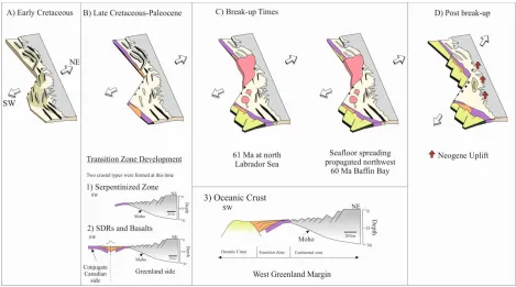
Aaisaa basin in the Disko West Province; the Lady Franklin, Kangamuit, Sisimuit and Fylla
205
Structures Complex basins in Nuuk West Province; the South Fylla Structures Complex basin
206
and the Cape Farewell basin in Cape Farewell Province (Figure 1).
207
208
3.2 Baffin Bay Province (BBP) 209
The structure of Baffin Bay Province is characterized by two NW-SE trending grabens
210
(Kivioq and Melville Bays) that are separated by the intervening Melville Ridge (Figure 1).
211
The two grabens, which are broadly asymmetric, comprise features that are approximately 50
212
km wide and over 310 km long with sedimentary rocks thickness of up to 5.0 second TWTT
213
in the Melville Bay area (Figure 4). The Kivioq basin is 200 km long and 25 km wide;
214
whereas the Umberk basin is 80 km long by 50 km wide (Table 1). The Melville Ridge has
215
minor sedimentary rockson top of it (~0.1 second or less) suggesting that it remained a
216
structural high throughout most of the evolution of the margin (Figure 4).
217
218
The graben-controlling faults are commonly planar structures with displacements of up to 4.5
219
second TWTT, and are correlatable along trend as a single fault (Figure 4) in excess of 310
220
km in length in the interior of the Baffin Bay basin (Figure 1). In addition to the graben
221
forming structures, a number of intra-basin faults with the same orientation as the basin
222
bounding faults are observed with displacements of up to 1.0 second TWTT (Figure 4). As
223
would be expected, these latter faults have shorter lengths compared to the boundary faults.
224
Despite the distance from Baffin Bay to the closest well tie-point of 800 km away from the
226
representative seismic line, the continuous nature of the principal megasequence reflections
227
allows the correlation of the packages into the province with some degree of confidence. The
228
rift phase in Baffin Bay Province is Lower Cretaceous and was controlled by many of the
229
main basin bounding faults, e.g. the Melville Platform fault (Figure 4). However, not all the
230
faults were active during the earliest stages of rifting, with much of the regional vertical
231
displacement being accommodated on a master fault that is now in the middle of the Kivioq
232
basin. These dominant faults became inactive before the cessation of rifting (Figure 4).
233
Instead, the majority of thickening (often sedimentary rocks thickness up to 0.5 second
234
TWTT) during the late stage of rifting is localised onto the graben bounding faults (Figure 4)
235
such as the northern Kivioq Ridge Fault, the northern and southern Melville Ridge Fault and
236
the southern Melville Platform fault (Figures 1 and 4).
237
238
During the transition phase from Early Palaeocene to Mid-Miocene sedimentary rocks are
239
characterized by wedging and thickening towards the faults plane, are truncated against
240
Kivioq Ridge fault and are thinner than Cretaceous synrift deposits. The postrift package
241
from mid Miocene to present thins towards the south which is likely to be a reflection of a
242
reduction in sediment supply from the margin towards the north and differential compaction
243
(See Figures 1 and 4).
244
245
As noted, the Baffin Bay Province is dominated by a series of grabens demarcated to the
246
south by the Kivioq Ridge (Figure 4). Across the ridge there is a rapid transition over 20 km
247
from continental crust across the gravity high and into a transition zone (Figure 4). The
248
continental region as a whole is characterized by large rotated basement blocks composed of
249
seaward dipping faults and deep synrift basins. The central area of Baffin Bay is bounded by
a collapsed structure created by an inclined West limb and a sub-horizontal to gently dipping
251
eastern limb (Figure 4). The transition zone is characterized by thinner synrift sedimentary
252
rocks, basalts and seaward dipping reflectors (SDRs) that separates rotated continental
253
basement faulted blocks from the oceanic crust. The oceanic crust is interpreted in the
254
southwest part of Baffin Bay and evident as a chaotic reflection occurring at depth of ~4800
255
ms TWTT.
256
257
The most common fault geometry observed includes horst and graben structures resulting
258
from NW-SE normal faults that divide the Baffin Bay basin into NW-SE structural domains.
259
A SW fault also divides the Kiviog basin from the Upemavik basin (Figure 1). These
NE-260
SW faults, ridges and basins were initiated during the earliest phases of rifting (Figure 4).
261
Deposition of Cretaceous sedimentary rocks in Baffin Bay was into extensive basins in
262
Kivioq and Melville Bay basin (Figure 4) which is at least 5.0 second TWTT thick. The
263
Melville Ridge is a subsurface high on the NE part of the bay (Figure 4). The total
264
thicknesses in Melville and Kivioq basins are approximately 5.0 second to 4 seconds TWTT
265
respectively (Figure 4).
266
267
3.3 Disko West Province (DWP) 268
The deepest reflection that is imaged in the Disko West Province is the Paleocene Basalt
269
(PB), which is identified as a high-amplitude reflection and is mappable both across the
270
margin and along the Aasiaa basin. The Aasiaa basin is 350 km long and 30 to 110 km wide
271
and the Disko High is 280 km long and 40 to 60 km wide (Figure 1). The Nussuaq basin is
272
130 km long and 60 km wide (Table 1). This indicates that the volcanic rocks cover an area
273
of ~150,000 km2 (Figure 1). Evidence from boreholes, seismic reflection and refraction data
274
located both west and east of Disko Island indicate the presence of thick clastics rocks of
Cretaceous age (Chalmers et al., 1999; Dam et al., 2009, Funck et al., 2012; Suckro et al.,
276
2013 and 2012). This is supported by the presence of similarly aged stratigraphy that is found
277
in the east of the Disko West Province that has not been covered by basalt (Figure 1).
278
Although the basalt geometry is not imaged, the basalt reflection package is remarkably
279
continuous.
280
281
In Disko West Province, the faults are dominated by steeply dipping normal faults with a
282
series of half grabens with lengths of up to 350 km and widths of 110 km (Figures 1 and 5).
283
The faults show clear thickening of up to 0.6 second TWTT during the Top Cretaceous-Top
284
Paleocene package (Figure 5). In contrast to the basin bounding faults in Baffin Bay, these
285
faults (N-S and NW-SE) are present in sigmoidal plan view geometry and most likely
286
resembles fault within a pull-apart basin (Figures 1 and 5). This is supported by the presence
287
of strike-slip faults within the area. Towards the southwest, postbasalt faulting is very limited.
288
The exception is a few relatively small normal faults on the eastern flank and a normal fault
289
on the northern edge of the Davis Strait High (Figure 1). However, mapping of gravity and
290
magnetic anomalies suggest that oceanic crust is present with a probably age of 60 Ma
291
(Oakey and Chalmers, 2012). Reflections above the oceanic crust clearly show significant
292
thickening of postrift wedge (Figure 5) from approximately 0.1 second TWTT in the
293
northeast nearshore to 1.5 second TWTT in the southwest. This thickening is most evident in
294
the Mid-Miocene to Quaternary packages (Figure 5). The thickness variation is unrelated to
295
rifting but deposition of postrift packages into topography created by the emplacement of the
296
basalt.
297
298
The Nuuk West Province has a number of strike-slip structures that trend broadly in a
NE-300
SW orientation and are associated with the Ungava transform fault (Figure 1). In terms of this
301
province length, the Nuuk West Province is about 550 km long from the Fylla complex
302
structure to the Sisimut basin and has a width of 150 km in the north and 260 km in the south
303
(Table 1). The geometry in the south of the Nuuk West Province is remarkably different from
304
that to the north. Instead of a relatively unfaulted flexure, the south is dominated by a number
305
of basement highs (Hecla, Manlitsoq, Kangamuit, Fylla) separated by grabens and
half-306
grabens, different from the faulted north.
307
308
The absence of the Paleocene Basalt (PB) in this area (except on the Hecla and Maniisoq
309
Highs) allows the identification of Top Acoustic Basement (Bs) with greater certainty.
310
Cretaceous rifting is again interpreted in this region and the interpretation in this work
311
suggests a series of isolated, large (> 7 km) rift basins during this phase (Figure 6). The Late
312
Cretaceous package is more uniformly distributed and is mappable across at least some of the
313
basement highs suggesting postrift sedimenta in most of the margin (Figure 6). The nature of
314
this unit however is rather variable. Within the Lady Franklin and Nuuk (Figure 6); Sisimiut
315
(Figure 7); and South Fylla Structures Complex (Figure 8) basins there is demonstrable
316
thickening of strata into rift faults typical of synrift intervals. In contrast, many of the basin
317
faults within the Cretaceous grabens (e.g. Cape Farewell) show no thickening (Figure 8). This
318
may be an indication of how extension was progressively localised onto a limited number of
319
faults during the rift episode. Thick basalts are deposited on both flank of the Hecla High
320
(Figure 6) and a flower structure is interpreted within the Sisimiut basin (Figure 7).
321
Sediments of postrift package were probably deposited during thermal subsidence resulting in
322
onlapping of sediments onto the topography highs. In the Hecla High, postrift strata are thin
323
and post Mid- Miocene in age in contrast to the thick (~1.0 second TWTT) postrift packages
of the Fylla Structures Complex Area (Figure 6). The postrift sedimentary succession are
325
thicker (~2.0 second TWTT) in the Sisimiut and Kangamiut basins than in the (FSCA) and
326
Hecla basins (Gregersen and Skaarup, 2007). In addition, the eastern side of Sisimiut basin is
327
characterized by non-deposition of sediment resulting in the absence of Mid-Miocene to
328
present day (Figure 8).
329
330
3.5 Cape Farewell Province (CFP) 331
The Cape Farewell Province shows faults up to 200-400 km in length and typical throws of
332
0.5 seconds TWTT (Figures 1 and 8). The (SFSCA) is 400 km long and 100 km wide,
333
whereas the Cape Farewell is approximately 400 km long and 200 km wide (Table 1). One of
334
the faults has a throw of 1.5 second TWTT that may be the result of reactivation during the
335
late stage of rifting in Late Cretaceous (Figure 8). The Cape Farewell Province also marks a
336
significant narrowing in the width of the continental margin as the transition from attenuated
337
continental crust into full oceanic crust occurs over ~80 km (rather than >250 km as is the
338
case further north. On the continental crust the rifting geometry is dominated by relatively
339
planar faults and rotated faults blocks (Figures 1 and 8). The imaging of the footwall cut-offs
340
suggest faults remain planar and show no evidence of a listric geometry with depth. From
341
stratal thickening it is evident that the faults were active during the Cretaceous, similarly to
342
basins in the north. However, the fault throws are significantly smaller (maximum observed
343
throws are <0.5 second TWTT) in contrast to reactivated faults with throws of 1.5 second
344
TWTT. This difference in fault geometry is also reflected in a change of fault orientation.
345
Faults in the southern Nuuk West Province are dominated by a broadly north-south
346
orientation whereas in Cape Farewell they have a NW-SE orientation.
347
In the more distal portion of the basin, the lower section is characterized by low amplitude
349
reflectivity suggestive of oceanic crust at ~ 8 seconds TWTT (Figure 8). In addition, the
350
presence of ~ 80 km wide magnetic (70 Ma) and (60 Ma) at the south and north respectively
351
further justifies the presence of the oceanic crust (cf. Chalmers and Laursen 1995; Figures 1
352
and 8). The seismic character of the area between the attenuated continental crust containing
353
the rift faults and the oceanic crust is rather enigmatic and may be either Seaward Dipping
354
Reflector (SDR), basaltic intrusions; this is interpreted as the transition zone (Figure 8). It is
355
onlapped by the Upper Cretaceous unit and then overlain by Paleocene basalts that are
356
attributed to break-up related magmatism. These volcanic rocks appear to mask all internal
357
reflections at a transition zone of c. 80 km observed between the oceanic and continental
358
crust. The west section of the transition zone has high amplitude reflectors that may be
359
seaward dipping reflections (Figure 8), and this, coupled to a positive gravity anomaly above
360
it, suggests that it is a late stage volcanic event that may have been the pre-cursor to break-up.
361
Overlying the entire section (Figure 8), including the oceanic and continental crust, is a
362
postrift sequence with a rather constant thickness of ~1.3 second TWTT, reflecting a uniform
363
subsidence across the margin. The exceptions are postrift packages of Palaeocene to Eocene
364
ages, which show local onlap onto both the margin to the east and a volcanic edifice on the
365
ocean crust.
366
367
4.0 Discussion. 368
4.1 Models of the Tectonic Development of the West Greenland margin 369
The development of the West Greenland margin involved deposition of thick sediment
370
wedges during rifting, faulting of the rift sequence, and erosion of fault scarps that formed
371
during early lithospheric extension by postrift sedimentation. The regional erosion during the
372
latter stage is revealed by Mid-Eocene and Early Miocene unconformities. The rift event
interpreted in this study area occurred intermittently with the emplacement of volcanic rocks
374
during the Palaeocene and Eocene. Categorically, the pre-rift packages are flanked by an
375
irregular dome structure in Cape Farewell; the dome is interpreted as a remnant of the
376
oceanic crust or serpentine zone (Figure 9), and it is shown as chaotic and high-amplitude
377
reflection at a deeper stratigraphic level on the seismic data (Figure 8). Furthermore, we
378
surmise that the boundaries of the oceanic crust are delimited by a probably zone of SDRs
379
developed prior the initial opening of the oceanic crust. Neogene uplift, post seafloor
380
spreading are dated ~11-10 Ma and 7-2 Ma (cf. Chalmers, 2000; Green et al., 2011; Japsen et
381
al., 2006). These observations all suggest a rather complex and variable margin evolution.
382
383
We propose a tectonic model that integrates the seismic interpreted faulting and overall basin
384
geometry with the key stage of tectonic development (Figure 9):
385
I. Rifting stage (145-130 Ma): NE-SW extension across the West Greenland margin.
386
This rift produced rotated fault blocks that formed horsts and grabens in the Cape
387
Farewell, Baffin Bay and Nuuk West Provinces. The basin geometry in Disko West
388
Province at this stage is not covered by the available seismic data. However,
389
deposition of Cretaceous age strata onshore suggests that the province was affected by
390
this rift stage. Late stage rifting comprises an early magmatic pulse during which the
391
margin was intruded by dykes in Nuuk West and probably Disko West.
392
393
II. Magma-poor phase (80-70 Ma): recorded as the development of a continental-ocean
394
transition zone that presumably includes attenuated continental crust in the Cape
395
Farewell and Baffin Bay provinces or serpentinised zone. Possible thermal subsidence
396
occurs on other areas across the West Greenland margin. The margin underwent
397
postrift thermal subsidence as materialised by the marine mudstones of Kangeq
sequence, which show little evidence of extension prior to the onset of seafloor
399
spreading at 60 Ma (Chalmers 2012).
400
III. Seafloor spreading (70-60 Ma): Seafloor spreading started in the south of Cape
401
Farewell Province (70 Ma) and is likely to have propagated to the northwest of Cape
402
Farewell Province (61 Ma) and then transferred to Baffin Bay via the Ungava fault
403
zone to form oceanic crust at (60 Ma) (See figure 9). The presence of a Magnetic high
404
suggests uniform stretching of the lithosphere in Cape Farewell. Disko West and
405
Baffin Bay showed magnetic low implying slow seafloor spreading on an underlying
406
strongly extended continental crust and/or serpentinised mantle (Reid and Jackson,
407
1997). We propose that the cessation of seafloor spreading occurred during (48 Ma)
408
and at (33 Ma) in Cape Farewell and Baffin Bay Provinces respectively, corroborating
409
the works of Chalmers and Pulvertaft (2001) and Oakey and Chalmers (2012). The
410
shift in spreading axis was from NNE in Palaeocene to NNW in Eocene in Baffin Bay
411
(See also Oakey and Chalmers, 2012). This is attributed to an anticlockwise rotation
412
of spreading axis by the oceanic crust or a shift in magmatic intrusion from West to
413
East Greenland. Hence, the margin subsided after the breakup in the Davis Strait in
414
Palaeocene to Late Eocene times, supporting the model of postrift subsidence reported
415
onshore Disko and Nuussuaq basins (cf. Green et al., 2011).
416
417
4.2 Magmatism and influence of the mantle plume 418
For the study area, there continues to be a debate whether the Eocene and Palaeocene
419
volcanism events are the product of multiple mantle plumes or a single mantle plume. The
420
separation and movement of the Greenland and Canada cratons were probably influenced by
421
the migration of a mantle plume that may have caused transient thermal uplift, extension and
422
subsequent plate movements (Harrison et al., 1999). Several authors favoured a single plume
hypothesis for the emplacement of all the volcanic provinces (Larsen et al., 1999; Nielsen et
424
al., 2002; Storey et al., 1998; Torsvik et al., 2001). The geochemistry of early picrites of West
425
Greenland are similar to subaerial Icelandic basalts and are formed by similar greater degrees
426
of melting of their source mantle than their Icelandic counterparts (Holm et al., 1993). The
427
volcanic eruption of the West Greenland picrites occurred ~5-6 Ma earlier than the start of
428
volcanism in eastern Greenland (Gill et al., 1995). A possible scenario describing the plume
429
dynamics under West Greenland is that the ~ 60 Ma events involves volcanism from a fast
430
moving upper mantle plume that rapidly spreads out horizontally on encountering the base of
431
the lithosphere (cf. Larsen et al., 1999; Nielsen et al., 2002). Palaeomagnetic reconstructions
432
show that mantle and crust processes are linked via complex and enigmatic cause-and-effect
433
relationships (Torsvik et al., 2001).
434
435
Our data analysis supports the notion that the West Greenland plume formed at ~60 Ma as
436
suggested by earlier workers (e.g. Storey et al, 1998). Critically, there was early rifting along
437
the whole margin during a magma-poor phase with more extension recorded in the south. The
438
evidence is for a plume that is present at the transfer zone rather than at the area of greatest
439
extension. Subsequently, the plume played a minor role in rift initiation and development.
440
Therefore, we suggest that the role of the plume was less significant than proposed by
441
previous authors. The plume may have contributed to the cessation of rifting in the study
442
area. Our model proposes that the West-Greenland volcanic margin developed after a period
443
of amagmatic extension during the Cretaceous in accord with the work of Abdelmalak et al.
444
(2012). Consequently, the area was subjected to regional uplift in the Danian (65–60Ma)
445
before the extrusion of pre-breakup magmatic rocks.
446
447
Based on the model defined in section 4.1, we propose a) multiphase extension and
449
continental breakup for the West Greenland margin and that b) individual basins within West
450
Greenland comprise both magma-poor and rich basins. The seismic stratigraphic division
451
from this work is consistent with the classification of Schenk (2011). As the transition from
452
rifting to drifting is marked by the breakup unconformity (BU) of Falvey (1974) and Franke
453
(2013); the BU in this study is the mid-Miocene horizon. Angular unconformities with
454
erosional truncation on seismic profiles were interpreted as the Rift Onset Unconformity
455
(ROU) in line with the definition of Falvey, (1974). In the study area, the ROU is the Top
456
Cretaceous Horizon. The nature and position of the Ocean-Continent Transition (OCT) is
457
marked by the presence of Seward Dipping Reflectors (SDR). Structurally, the interpretation
458
of compressional and inversion structures accompanied by strike-slip faulting and local
459
transtensional faults and flexures are expression of the Eurekan orogeny (Gregersen et al.,
460
2013). However, the identification of the transition between synrift and postrift settings may
461
not always be reflected by a simple breakup unconformity (Alves et al., 2009; Soares et al.,
462
2012). These authors show that the “breakup unconformity” is a Lithospheric Breakup
463
Surface (LBS) that is not always developed as an unconformity and that the entire lithosphere
464
is involved in the breakup process, not only the continental crust. The complex nature of the
465
transition phase, which is stratigraphically between the demonstrable synrift and postrift
466
phases, in this study is a reflection that the simple concept of the breakup unconformity is not
467
applicable. Hence, the mid-Miocene (BU) may only indicate basinward shift of the
468
extensional locus and not the end of rifting processes along West Greenland margins (Falvey
469
1974; Soares et al., 2012).
470
471
Our model offers supporting evidence for the occurrence of a passive continental margin
472
comprised of both magma-rich and magma-poor lithospheric extension. Since most passive
margins develop in response to lithospheric extension, passive margins can be classified into
474
two end-members depending on the volume of extension-related magmatism (Franke, 2013).
475
Baffin Bay and Labrador Sea are magma-rich margins characterized by SDRs at their
ocean-476
continent transition. Keen et al (2012) showed that the Labrador Sea is exemplified by the
477
presence of excess magmatism, SDRs, and volcanic plateau and thick igneous crust. This
478
agrees with the classification of Funck et al (2007) and Gerlings et al (2009). In contrast,
479
Skaarup et al (2000) proposed that the Labrador Sea is a non-volcanic margin. From this
480
work, the Davis Strait is interpreted as a magma-poor margin that is defined by a wide area of
481
highly attenuated crust where the upper crust is deformed by planar faults. Unlike other
482
magma-poor passive margins, the detachment over which the fault soles was not interpreted.
483
Therefore, the West Greenland to the north and south are magma-rich margins while centrally
484
it is magma-poor margin. This highlights that single margins can be highly variable and these
485
simple end members are not always applicable.
486
487
The role of mantle plumes in the evolution of magma-rich margins has been a subject of
488
debate. Crustal rifting can evolve in conjunction with a plume head as: a) where the plume
489
head triggers the rift evolution by a circular uplift in which the earliest and widest rift is
490
expected to be close to the plume head and the width of the rift decreases away from the
491
plume; and b) where the rift starts farther from the plume with a consistently decreasing
492
width of the rift toward the plume (Franke, 2013). Examples include Iberia–Newfoundland,
493
the Equatorial Atlantic Ocean, and East Antarctica–Australia. We have shown that extension
494
along the West Greenland was less dependent on the mantle plume and that continental
495
extension and break-up is not always associated with large amounts of volcanism.
496
The evolutionary model presented in this paper has implications for all aspects of
498
hydrocarbon prospectivity in West Greenland. Reservoir intervals are likely to be present in
499
synrift strata deposited in the observed half grabens of substantial size as well as postrift
500
clastic deposits (Table 1). These intervals include the fluvio-deltaic sandstones of the
501
Cretaceous Atane Formation in the Nuussuaq basin, the mid-Cretaceous to Paleocene marine
502
slope channel sandstones and the marine canyon sandstones equivalent to the incised valley
503
fill sandstones of the Paleocene Quikavsak Member (Dam et al., 2009; Dam et al., 1998). The
504
deposition of these intervals, and the facies variations within them, will be intimately
505
controlled by the basin and fault architecture that we have presented (Figure 9). Of equal
506
importance as reservoir distribution is the trapping mechanisms, which within our
507
interpretation are likely to include both structural and stratigraphic plays. Early rotated faults
508
blocks, grabens and their horsts are important structural trap forming three-way closure.
509
Additional trapping mechanism may include Upper Cretaceous compressional structures and
510
rollover four-way closures formed by synrift packages (Figure 6).
511
512
The Paleocene was a time of widespread volcanic activity in the central part of the Davis
513
Strait (Larsen and Pulvertaft, 2000; Pedersen and Larsen, 2006), when several kilometres of
514
plume-related volcanic rocks were extruded regionally. Consequently, basalts extruded into
515
Cretaceous strata are going to alter both reservoir and basin scale heat flow scenarios. The
516
synvolcanic strata of the Baffin Bay Province may be of interest for hydrocarbon exploration
517
activity (Pedersen et al., 2002) with the stratigraphic position of volcanic rocks is playing a
518
role on reservoir scale source rock maturation. The Neogene was a time of widespread clastic
519
input along north Atlantic passive margins, indicative of Neogene uplift that has been
520
documented from many onshore locations around the Arctic and north Atlantic (Japsen et al.,
521
2005; Japsen and Chalmers, 2000). The implications of such uplift are poorly constrained on
other margins but are likely to influence sediment supply, geometry of stratigraphic traps and
523
may also alter regional heat flows (Paton et al., 2008).
524
525
5.0 Conclusion 526
We present a new structural framework for the West Greenland margin. This reveals a long
527
and complex evolution, and in particular demonstrates:
528
Rifting margin in Early Cretaceous with synrift packages intercalated with volcanic
529
sills. The Palaeocene basalt occurred in the Disko West, south Baffin Bay and the
530
north Cape Farewell Provinces. These extrusive rocks are connected with the breakup
531
stage during the development of the West Greenland margin.
532
The architecture of faults in the Davis Strait High suggests continuity between the
533
structures of Labrador Sea and Baffin Bay. Strike-slip faults in the Davis Strait acted
534
as transfer zones for displacement during seafloor spreading during and after volcanic
535
activity.
536
Incipient rifting on the West Greenland margin was unaffected by the mantle plume.
537
Seafloor spreading started in the Cape Farewell, propagated to the north West and
538
later slowly to Baffin Bay where the underlying continental crust is strongly extended
539
over a probable serpentinised mantle.
540
The basins on the West Greenland margin such as the Sisimiut, Kangamiut and
541
Melville Bay Graben have significant potential for hydrocarbon reservoir and seal in
542
thick Cretaceous strata. Structural traps include half grabens and grabens with further
543
potential in possibly inverted structures.
544
The West Greenland margin is characterized by magma-rich and poor basins.
545
In conclusion, tectono- stratigraphic packages studied from seismic reflection and borehole
547
data interpretation has permitted the basin architecture to be established and allowed us to
548
construct a model for the tectonic development of West Greenland basins. The West
549
Greenland margin shows complex tectono-stratigraphy and the along margin variability, in
550
particular the variation of magma-poor to magma-rich margin, the relatively small influence
551
of plume emplacement, and the significant variation in rift architecture along the margin has
552
a significant impact on the hydrocarbon potential resources. Hence, the boarder basin
553
geometry have more accommodation space for sediments and higher potential for
554
hydrocarbon accommodation than their narrow counterparts.
555
556
557
Acknowledgement
558
We would like to thank GEUS and TGS for data. Saudi Aramco for funding, and also
559
reviewers; Tiago Alves and Chris Jackson for their every constructive comments
560
References 561
Abdelmalak, M. M., L. Geoffroy, J. Angelier, B. Bonin, J. P. Callot, J. P. Gélard, and C.
562
Aubourg, 2012, Stress fields acting during lithosphere breakup above a melting mantle: A
563
case example in West Greenland: Tectonophysics, v. 581, p. 132-143. doi:
564
http://dx.doi.org/10.1016/j.tecto.2011.11.020
Alves, T. M., C. Moita, T. Cunha, M. Ullnaess, R. Myklebust, J. H. Monteiro, and G.
566
Manuppella, 2009, Diachronous evolution of Late Jurassic–Cretaceous continental rifting in
567
the northeast Atlantic (west Iberian margin): Tectonics, v. 28, p. TC4003. doi:
568
10.1029/2008tc002337
569
Badley, M. E., 1985, Practical seismic interpretation, Medium: X; Size: Pages: 265 p.
570
Balkwill, H. R., N. J. McMillan, B. MacLean, G. L. Williams, and S. P. Srivastava, 1990,
571
Geology of the continental margin of Eastern Canada / edited by M.J. Keen and G.L.
572
Williams, v. 2: Ottawa :, Canadian Government Publishing Center.
573
Bojesen-Koefoed, J. A., F. G. Christiansen, H. P. Nytoft, and A. K. Pedersen, 1999, Oil
574
seepage onshore West Greenland: evidence of multiple source rocks and oil mixing:
575
Geological Society, London, Petroleum Geology Conference series, v. 5, p. 305-314. doi:
576
10.1144/0050305
577
Bojesen-Koefoed, J. A., H. P. Nytoft, and F. G. Christiansen, 2004, Age of oils in West
578
Greenland: Was there a Mesozoic seaway between Greenland and Canada: Geological
579
Survey of Denmark and Greenland Bulletin, v. 4, p. 49-52.
580
Burden, E. T., and A. B. Langille, 1990, Stratigraphy and sedimentology of Cretaceous and
581
Paleocene strata in half-grabens on the southeast coast of Baffin Island, Northwest
582
Territories: Bulletin of Canadian Petroleum Geology, v. 38, p. 185-196.
583
Chalmers, J. A., 1991, New evidence on the structure of the Labrador Sea/Greenland
584
continental margin: Journal of the Geological Society, v. 148, p. 899-908. doi:
585
10.1144/gsjgs.148.5.0899
586
Chalmers, J. A., 2000, Offshore evidence for Neogene uplift in central West Greenland:
587
Global and Planetary Change, v. 24, p. 311-318. doi: 10.1016/s0921-8181(00)00015-1
588
Chalmers, J. A., 2012, 11 - Labrador Sea, Davis Strait, and Baffin Bay, in D. G. Roberts, and
589
A. W. Bally, eds., Regional Geology and Tectonics: Phanerozoic Passive Margins, Cratonic
590
Basins and Global Tectonic Maps: Boston, Elsevier, p. 384-435.
591
Chalmers, J. A., and K. H. Laursen, 1995, Labrador Sea: the extent of continental and
592
oceanic crust and the timing of the onset of seafloor spreading: Marine and Petroleum
593
Geology, v. 12, p. 205-206. doi: 10.1016/0264-8172(95)92840-s
594
Chalmers, J. A., and T. C. R. Pulvertaft, 2001, Development of the continental margins of the
595
Labrador Sea: a review: Geological Society, London, Special Publications, v. 187, p. 77-105.
596
doi: 10.1144/gsl.sp.2001.187.01.05
597
Chalmers, J. A., T. C. R. Pulvertaft, F. G. Christiansen, H. C. Larsen, K. H. Laursen, and T.
598
G. Ottesen, 1993, The southern West Greenland continental margin: rifting history, basin
599
development, and petroleum potential: Geological Society, London, Petroleum Geology
600
Conference series, v. 4, p. 915-931. doi: 10.1144/0040915
Chalmers, J. A., T. C. R. Pulvertaft, C. Marcussen, and A. K. Pedersen, 1999, New insight
602
into the structure of the Nuussuaq Basin, central West Greenland: Marine and Petroleum
603
Geology, v. 16, p. 197-211, 213-224. doi: 10.1016/s0264-8172(98)00077-4
604
Clift, P. D., and J. Turner, 1995, Dynamic support by the Icelandic plume and vertical
605
tectonics of the northeast Atlantic continental margins: Journal of Geophysical Research:
606
Solid Earth, v. 100, p. 24473-24486. doi: 10.1029/95jb02511
607
Corti, G., 2009, Continental rift evolution: From rift initiation to incipient break-up in the
608
Main Ethiopian Rift, East Africa: Earth-Science Reviews, v. 96, p. 1-53. doi:
609
http://dx.doi.org/10.1016/j.earscirev.2009.06.005
610
Dalhoff, F., J. A. Chalmers, U. Gregersen, H. Nøhr-Hansen, J. Audun Rasmussen, and E.
611
Sheldon, 2003, Mapping and facies analysis of Paleocene–Mid-Eocene seismic sequences,
612
offshore southern West Greenland: Marine and Petroleum Geology, v. 20, p. 935-986. doi:
613
10.1016/j.marpetgeo.2003.09.004
614
Dam, G., M. Larsen, and M. Sønderholm, 1998, Sedimentary response to mantle plumes:
615
Implications from Paleocene onshore successions, West and East Greenland: Geology, v. 26,
616
p. 207-210. doi: 10.1130/0091-7613(1998)026<0207:srtmpi>2.3.co;2
617
Dam, G., H. Nøhr-Hansen, G. K. Pedersen, and M. Sønderholm, 2000, Sedimentary and
618
structural evidence of a new early Campanian rift phase in the Nuussuaq Basin, West
619
Greenland: Cretaceous Research, v. 21, p. 127-154. doi: 10.1006/cres.2000.0202
620
Dam, G., G. K. Pedersen, M. Sønderholm, H. H. Midtgaard, L. M. Larsen, H. Nøhr-Hansen,
621
and A. K. Pedersen, 2009, Lithostratigraphy of the Cretaceous–Paleocene Nuussuaq Group,
622
Nuussuaq Basin, West Greenland: Geological Survey of Denmark and Greenland Bulletin, v.
623
19, p. 1-171.
624
Davies, G., 1998, A channelled plume under Africa: Nature, v. 395, p. 743-744. doi:
625
10.1038/27320
626
Falvey, D. A., 1974, The development of continental margins in plate tectonic theory: APEA
627
J, v. 14, p. 95-106.
628
Franke, D., 2013, Rifting, lithosphere breakup and volcanism: Comparison of magma-poor
629
and volcanic rifted margins: Marine and Petroleum Geology, v. 43, p. 63-87. doi:
630
http://dx.doi.org/10.1016/j.marpetgeo.2012.11.003
631
Funck, T., K. Gohl, V. Damm, and I. Heyde, 2012, Tectonic evolution of southern Baffin
632
Bay and Davis Strait: Results from a seismic refraction transect between Canada and
633
Greenland: J. Geophys. Res., v. 117, p. B04107. doi: 10.1029/2011jb009110
634
Funck, T., H. R. Jackson, K. E. Louden, and F. Klingelhöfer, 2007, Seismic study of the
635
transform-rifted margin in Davis Strait between Baffin Island (Canada) and Greenland: What
636
happens when a plume meets a transform: Journal of Geophysical Research: Solid Earth, v.
637
112, p. n/a-n/a. doi: 10.1029/2006jb004308
Gerlings, J., T. Funck, H. R. Jackson, K. E. Louden, and F. Klingelhoefer, 2009, Seismic
639
evidence for plume-derived volcanism during formation of the continental margin in southern
640
Davis Strait and northern Labrador Sea: Geophysical Journal International, v. 176, p.
980-641
994. doi: 10.1111/j.1365-246X.2008.04021.x
642
Gill, R. C. O., P. M. Holm, and T. F. D. Nielsen, 1995, Was a short-lived Baffin Bay plume
643
active prior to initiation of the present Icelandic plume? Clues from the high-Mg picrites of
644
West Greenland: Lithos, v. 34, p. 27-39. doi: 10.1016/0024-4937(95)90007-1
645
Green, P. F., P. Japsen, J. A. Chalmers, and J. M. Bonow, 2011, Thermochronology, erosion
646
surfaces and missing section in West Greenland: Journal of the Geological Society, v. 168, p.
647
817-830. doi: 10.1144/0016-76492010-124
648
Gregersen, U., and T. Bidstrup, 2008, Structures and hydrocarbon prospectivity in the
649
northern Davis Strait area, offshore West Greenland: Petroleum Geoscience, v. 14, p.
151-650
166. doi: 10.1144/1354-079308-752
651
Gregersen, U., J. R. Hopper, and P. C. Knutz, 2013, Basin seismic stratigraphy and aspects of
652
prospectivity in the NE Baffin Bay, Northwest Greenland: Marine and Petroleum Geology, v.
653
46, p. 1-18. doi: http://dx.doi.org/10.1016/j.marpetgeo.2013.05.013
654
Gregersen, U., and N. Skaarup, 2007, A mid-Cretaceous prograding sedimentary complex in
655
the Sisimiut Basin, offshore West Greenland—stratigraphy and hydrocarbon potential:
656
Marine and Petroleum Geology, v. 24, p. 15-28. doi:
657
http://dx.doi.org/10.1016/j.marpetgeo.2006.10.005
658
Griffiths, R. W., and I. H. Campbell, 1990, Stirring and structure in mantle starting plumes:
659
Earth and Planetary Science Letters, v. 99, p. 66-78. doi:
http://dx.doi.org/10.1016/0012-660
821X(90)90071-5
661
Harrison, J. C., T. A. Brent, and G. N. Oakey, 2011, Chapter 40 Baffin Fan and its inverted
662
rift system of Arctic eastern Canada: stratigraphy, tectonics and petroleum resource potential:
663
Geological Society, London, Memoirs, v. 35, p. 595-626. doi: 10.1144/m35.40
664
Harrison, J. C., U. Mayr, D. H. McNeil, A. R. Sweet, J. J. Eberle, D. J. McIntyre, C. R.
665
Harington, J. A. Chalmers, G. Dam, and H. Nohr-Hansen, 1999, Correlation of Cenozoic
666
sequences of the Canadian Arctic region and Greenland; implications for the tectonic history
667
of northern North America: Bulletin of Canadian Petroleum Geology, v. 47, p. 223-254.
668
Holm, P. M., R. C. O. Gill, A. K. Pedersen, J. G. Larsen, N. Hald, T. F. D. Nielsen, and M. F.
669
Thirlwall, 1993, the tertiary picrites of west greenland - contributions from icelandic and
670
other sources: Earth and Planetary Science Letters, v. 115, p. 227-244. doi:
10.1016/0012-671
821x(93)90224-w
672
Huismans, R., and C. Beaumont, 2011, Depth-dependent extension, two-stage breakup and
673
cratonic underplating at rifted margins: Nature, v. 473, p. 74-78. doi:
http://www.nature.com/nature/journal/v473/n7345/abs/10.1038-nature09988-675
unlocked.html#supplementary-information
676
Japsen, P., J. M. Bonow, P. F. Green, J. A. Chalmers, and K. Lidmar-Bergström, 2006,
677
Elevated, passive continental margins: Long-term highs or Neogene uplifts? New evidence
678
from West Greenland: Earth and Planetary Science Letters, v. 248, p. 330-339. doi:
679
http://dx.doi.org/10.1016/j.epsl.2006.05.036
680
Japsen, P., and J. A. Chalmers, 2000, Neogene uplift and tectonics around the North Atlantic:
681
overview: Global and Planetary Change, v. 24, p. 165-173. doi:
682
http://dx.doi.org/10.1016/S0921-8181(00)00006-0
683
Japsen, P., P. F. Green, and J. A. Chalmers, 2005, Separation of Palaeogene and Neogene
684
uplift on Nuussuaq, West Greenland: Journal of the Geological Society, v. 162, p. 299-314.
685
doi: 10.1144/0016-764904-038
686
Keen, C. E., K. Dickie, and S. A. Dehler, 2012, The volcanic margins of the northern
687
Labrador Sea: Insights to the rifting process: Tectonics, v. 31, p. n/a-n/a. doi:
688
10.1029/2011tc002985
689
Knutsen, S. M., N. P. Arendt, M. K. Runge, J. Stilling, and M. P. Brandt, 2012, Structural
690
provinces offshore West Greenland and key geological variations influencing play
691
assessment: First Break v. 30, p. 43-55. doi: 10.3997/1365-2397.2012021
692
Larsen, J. G., and T. C. R. Pulvertaft, 2000, The structure of the Cretaceous-Palaeogene
693
sedimentary-volcanic area of Svartenhuk Halvø, central West Greenland, v. 188, Geological
694
Survey of Denmark and Greenland, Ministry of Environment and Energy.
695
Larsen, T. B., D. A. Yuen, and M. Storey, 1999a, Ultrafast mantle plumes and implications
696
for flood basalt volcanism in the Northern Atlantic Region: Tectonophysics, v. 311, p. 31-43.
697
doi: 10.1016/s0040-1951(99)00163-8
698
Lister, G. S., M. A. Etheridge, and P. A. Symonds, 1986, Detachment faulting and the
699
evolution of passive continental margins: Geology, v. 14, p. 246-250. doi:
10.1130/0091-700
7613(1986)14<246:dfateo>2.0.co;2
701
Lundin, E. R., and A. G. Doré, 2011, Hyperextension, serpentinization, and weakening: A
702
new paradigm for rifted margin compressional deformation: Geology, v. 39, p. 347-350. doi:
703
10.1130/g31499.1
704
McGregor, E. D., S. B. Nielsen, R. A. Stephenson, O. R. Clausen, K. D. Petersen, and D. I.
705
M. Macdonald, 2012, Evolution of the west Greenland margin: offshore thermostratigraphic
706
data and modelling: Journal of the Geological Society, v. 169, p. 515-530. doi:
10.1144/0016-707
76492011-139
708
McKenzie, D., 1978, Some remarks on the development of sedimentary basins: Earth and
709
Planetary Science Letters, v. 40, p. 25-32. doi:
http://dx.doi.org/10.1016/0012-710
821X(78)90071-7
Merle, O., 2011, A simple continental rift classification: Tectonophysics, v. 513, p. 88-95.
712
doi: http://dx.doi.org/10.1016/j.tecto.2011.10.004
713
Mitchum Jr, R. M., P. R. VAIL, and J. B. SANGREE, 1977, Seismic stratigraphy and global
714
changes of sea level, part 11:Stratigraphic Interpretation of Seismic Reflection Patterns in
715
Depositional Sequences: AAPG Bulletin, v. Memoir 26, p. 117-133.
716
Müller, R. D., M. Sdrolias, C. Gaina, and W. R. Roest, 2008, Age, spreading rates, and
717
spreading asymmetry of the world's ocean crust: Geochem. Geophys. Geosyst., v. 9, p.
718
Q04006. doi: 10.1029/2007gc001743
719
Nielsen, T. K., H. C. Larsen, and J. R. Hopper, 2002, Contrasting rifted margin styles south
720
of Greenland: implications for mantle plume dynamics: Earth and Planetary Science Letters,
721
v. 200, p. 271-286. doi: 10.1016/s0012-821x(02)00616-7
722
Nøhr-Hansen, H., and G. Dam, 1997, Palynology and sedimentology across a new marine
723
Cretaceous-Tertiary boundary section on Nuussuaq, West Greenland: Geology, v. 25, p.
851-724
854. doi: 10.1130/0091-7613(1997)025<0851:pasaan>2.3.co;2
725
Oakey, G. N., and J. A. Chalmers, 2012, A new model for the Paleogene motion of
726
Greenland relative to North America: Plate reconstructions of the Davis Strait and Nares
727
Strait regions between Canada and Greenland: J. Geophys. Res., v. 117, p. B10401. doi:
728
10.1029/2011jb008942
729
Paton, D. A., D. van der Spuy, R. di Primio, and B. Horsfield, 2008, Tectonically induced
730
adjustment of passive-margin accommodation space; influence on the hydrocarbon potential
731
of the Orange Basin, South Africa: AAPG Bulletin, v. 92, p. 589-609
732
Pedersen, A. K., and L. M. Larsen, 2006, The Ilugissoq graphite andesite volcano, Nuussuaq,
733
central West Greenland: Lithos, v. 92, p. 1-19. doi:
734
http://dx.doi.org/10.1016/j.lithos.2006.03.027
735
Pedersen, A. K., L. M. Larsen, P. Riisager, and K. S. Dueholm, 2002, Rates of volcanic
736
deposition, facies changes and movements in a dynamic basin: the Nuussuaq Basin, West
737
Greenland, around the C27n-C26r transition: Geological Society, London, Special
738
Publications, v. 197, p. 157-181. doi: 10.1144/gsl.sp.2002.197.01.07
739
Pik, R., B. Marty, and D. R. Hilton, 2006, How many mantle plumes in Africa? The
740
geochemical point of view: Chemical Geology, v. 226, p. 100-114. doi:
741
http://dx.doi.org/10.1016/j.chemgeo.2005.09.016
742
Reid, I., and H. R. Jackson, 1997, Crustal structure of northern Baffin Bay: Seismic refraction
743
results and tectonic implications: J. Geophys. Res., v. 102, p. 523-542. doi:
744
10.1029/96jb02656
745
Reston T.J and M. Pérez-Gussinyé, 2007. Lithospheric extension from rifting to continental
746
break-up at magma-poor margins: rheology, serpentinisation and symmetry. Int. J. Earth Sci.,
747
doi:10.1007/s00531-006-0161-z