Abstract: The goal of the research is to develop technological and software tools to create an urban geographic information system (UGIS). The research objectives are to develop the principles of creation of a single information space of the city and organize UGIS information resources. Moreover, the authors aim to develop UGIS conceptual architecture, principles of organization of UGIS geospatial data, as well as software, organization and technical support for creation and operation for UGIS. To address these objectives an expert survey method was used to define the conceptual architecture and UGIS software tools. Employees of municipal administration of Departments of Property and Land Relations, Departments of Construction Policy, as well as Chief Architects, were involved in the expert survey. According to the research results, an approach for building a UGIS based on single structured city-wide storage of base information resources has been developed. The conceptual architecture of the system and functions and means of its implementation have been proposed.
Index Terms: municipal formation, city, information system, geographic information system, geospatial data, GIS technologies.
I.INTRODUCTION
It is obvious today that the informatization of society is a global and unavoidable process in the development of human civilization. Problems of development and implementation of information technologies are in the purview of both scientists and a wide range of practitioners in all spheres of human activity. Informatization is conditioned by both the needs of research and technology advancement, as well as its importance in the modern information society.
Existence and development of modern municipal formations are impossible without effective work of municipal services organizations. The more exhaustive and better the information available to municipality, the more effective is the management and distribution of resources at disposal of the municipality. Thus, the competence of municipal management and the importance of its results for population increases. Implementation of urban geographic information system (UGIS) ensures the creation of a single
Revised Manuscript Received on July 05, 2019
Satsita Salikhovna Hasanova, Department of Taxes and taxation of the Institute of Economics and Finance of the Chechen state University, Grozny, Russia.
L.V. Pogosyan, Russian State Social University, Moscow, Russia. Aleksey Valeryevich Novikov, Research Institute of the Federal Penitentiary Service of Russia, Moscow, Russia; Criminal Law Department of Astrakhan state University, Astrakhan, Russia; Civil Law DepartmentRussian Customs Academy, Lyubercy, Russia.
Ruslan Vakhayevich Batashev, Institute of economy and finance, Chechen state university, Grozny, Russia.
information framework, which promotes the performance of various activities by municipal administration authorities at a more integrated level [1].
In leading countries of the world, UGIS and modeling systems based on geoinformation technologies are used to create conditions of forecasted development of territories and settlements, more effective management and support of urban planning activity, improvement of the environmental and man-made state of settlements, as well as preparation of proposals for management decision making [2].
Analysis of the current status of information technologies implementation in the urban economy management processes shows that Russia, like the world in general, already has certain experience in GIS development and operation. Urban information systems and their sub-systems are created and implemented in the cities of Moscow, Ufa, Perm, Novosibirsk, etc. Putting these systems into practice gives grounds for the following conclusions:
1) spatial information is the integrating basis, which gives an opportunity to take an integrated approach to the solution of economic, political, social and environmental problems in the territory of settlement because all urban management objectives are related to the location of objects, subjects and events in this territory [3];
2) effective use of modern information technologies for planning, development and operation management of a settlement requires the creation of a single city-wide system for collection, storage and distributive processing of spatial public information [4].
II.LITERATUREREVIEW
Managing urban infrastructure and land resources is a complex process requiring the presence of reliable data on the current state of affairs, as well as effective mechanisms for processing and clear interaction of divisions and services of a settlement. Therefore, a necessary condition for effective management of even a small administrative unit is the use of modern information technologies and development of effective mechanisms for information collection, processing and issue, as well as procedures and technical means for data exchange between divisions and structures of local government and administration bodies [5].
Various aspects of GIS implementation in conditions of municipalities have been considered by many scientists and practitioners.
Thus, A. M. Sadykov developed a mathematical model of geoinformation analysis for forecasting and
Urban Geographic Information System: Features
of Implementation and Management
development of recommended solutions with a probabilistic evaluation of their effectiveness for allocation of technical facilities in an urban area. The same author proposed a decision-making methodology using GIS in management of the urban property on the grounds of the formal description of situations based on a fuzzy description of the main elements of formalized representation of situations. This research focuses on the creation and implementation of information technologies in the urban management system, which is a general objective in respect to urban economy management [6].
In his research, V. V. Gokhman [7] structurizes the GIS of urban resources accounting and management and develops a set-theoretic GIS model for managing the urban resources, which makes it possible to uniquely define a GIS as a system consisting of elements selected by a finite and computable collection of limitations and conditions. The work reviews the creation of an information system for urban resources management.
The complexity of the territorial processes management system forces one to decompose the management problem into sub-tasks. For the solution of each of them, separate management blocks must be created. Thus, Indian scientists [8] note that information system of urban management consists of GIS, DBMS (database management system), DSS (decision support system) and expert systems. DSS are a specific class of computerized systems that support the activity related to making decisions particularly in the subject area of territorial management. Modern DSS are interactive automated systems, which help responsible persons to effectively use communication technologies, data, documents, knowledge and/or models for identification and solution of problems and decision-making. Formally, the researchers speak of five specific types of DSS: communication-based
DSS; data-based DSS; document-based DSS;
knowledge-based DSS; model-based DSS. In their view, it is advisable to use GIS as a formalized computer system, capable of integrating the data from various sources, then the
integrated information received from GIS is used for management decision-making. That is, GIS ensures the process of managing the necessary data and is used directly as a tool for reflection of management result.
Thus, complex GIS of a settlement is a tool for integration and analysis of diverse information regarding spatial infrastructure facilities of settlement and is intended for complex information and analytical support of activity of management and officials of local authorities, organizations, enterprises and population, as well as centralized analysis and forecast of social and economic indices of settlement development.
III.METHODS A. General description
To address the specified problems, an expert survey method was employed for determining the conceptual architecture and UGIS tools.
Employees of municipal administration (16 experts in total) of Departments of Property and Land Relations (5 experts), Departments of Construction Policy (6 experts), Chief Architects (5 experts) were involved in the expert survey.
During the expert survey, the experts were requested to provide the principal characteristics of the architecture of UGIS software tools and the structure of UGIS base information resources and articulate conceptual requirements for UGIS tools.
B. Algorithm
[image:2.595.155.450.533.661.2]Processing of the survey results consisted of a schematic representation of the architecture of UGIS software tools based on software products with open code and structure of UGIS base information resources (Fig. 1).
Fig. 1. Research algorithm.
IV.RESULTS
A. UGIS architecture
According to the experts, UGIS is a tool for integration and analysis of diverse information concerning spatial infrastructure facilities of the city and is intended for complex information and analytical support of activity of management
and officials of local authorities, organizations, enterprises and population of the city, as well as centralized analysis and forecast of social and economic indices of urban development. UGIS is created as a set of uniform information subsystems that use a single
digital cartographic base
(SDCB) and spatial
city.
Experts believe that SDCB and city’s spatial information model pertain to base information resources of the city, which should contain complete and consistent information about the infrastructure facilities of the municipal economy and other facilities located within the city including their geographic location on digital maps.
UGIS subsystems are intended for prompt information support of users in accordance with the problems they solve and their authorities. For the implementation of its functionality, each of the subsystems uses its own information model of territory that is built based on SDCB and separate information layers of the city’s spatial model.
The expert survey showed that UGIS base subsystems include:
- Address system (AS) of the city;
- The automated system of land cadaster (ASLC) of the city;
- The automated system of property cadaster (ASPC) of the city;
- The automated system of the next digital plan maintenance (ASNDPM) of the city;
- Authorization and authority division subsystem.
UGIS software tools should be built using modern WEB-technologies that ensure distributed processing of data and do not require additional software at the client workplaces.
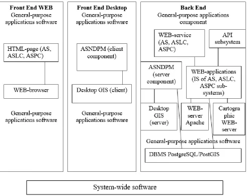
According to the expert survey results, the architecture of UGIS software tools was developed based on software products with open code, which is given in Fig. 2.
[image:3.595.64.556.273.662.2]Functioning of UGIS in the cities should be maintained by respective organization and technical structure, statutory and legal, information, software, methodic, technological and financial support.
Fig. 2. The architecture of UGIS software tools based on software products with open code.
As the experts argue, UGIS is created as a single information system with universal storage of urban public information resources – base information resources of the city, whose structure is shown in Fig. 3. Thus, based on UGIS,
Fig. 3. Structure of UGIS base information resources.
B. Concept of UGIS tools
When it comes to UGIS tools, it should be noted that they represent a set of systematic coordinated software components and applications that are used as part of UGIS software. The tools are used in the creation of software of any UGIS subsystem in order to unify solutions on the subsystem’s program structure that ensure technological capabilities of customization, administration and initial data input.
In the opinion of the experts, UGIS tools are divided into the following categories:
- systems tools (software platforms for development or functioning of applications software, DBMS);
- functional components (program code blocks implementing certain uniform functions are integrated into applications software);
- interface tools (implement uniform program interfaces, are integrated into applications software);
- tools for forming and editing the spatial information of the digital model of the territory;
- tools for visualization of spatial and attributive information of digital models of the territory;
- tools for documenting spatial and attributive information (implement uniform functions of document generation as per established templates, are integrated into application software);
- document management tools (accounting, storage and control of document flow).
Tools are an integral part of UGIS creation technology.
UGIS creation technology determines the list of existing tools, directions of their further development and improvement, as well as their application procedure.
According to the experts, the most popular tools and technologies for UGIS creation in Russia are as follows:
- family of ArcGIS software tools by ESRI firm, USA; - MapInfo software package by Mapping Information Systems Corporation, USA;
- MicroStation software package by MicroStation, USA; - set of software tools by Panorama, Russia, etc.
When discussing the implementation of UGIS, the experts paid special attention to the issues of land resources management and the formation of urban planning cadaster (UPC).
As for the application of GIS in land resources management as one of its areas of use, it should be noted that land resources management of a settlement is a complicated process, which requires reliable data on the current state of affairs, effective mechanisms of their collection and clear interaction of divisions and services of the settlement. Therefore, the necessary condition for effective management of even a small administrative unit is the use of modern information technologies, development of effective information collection, processing and issue mechanisms, as well as procedures and technical means of data exchange between divisions and structures of local government and administration bodies.
literally the most complex one in terms of soil composition, functional use, forms of ownership and limitation of the property right to land, as well as a list of issues of both social economic and environmental nature.
Among many problems of land resources management in settlements, the experts identify the following most vital problems:
1) there is a need for land inventory in settlements based on their designated use, legal regime, quality and economic status and zoning address because it allows the detection of vacant plots, as well as the plots that are used other than intended. In this respect, the problematic aspect is noncompliance of master plans with modern requirements and new standards on land relations, as well as complications in the provision of investors with reliable land cadaster and urban planning information for the justified formation of their intentions regarding the most effective capital investments in the land of settlements. Thus, objective data of the city’s land cadaster becomes the basis for the functioning of not only land use planning bodies but commercial structures as well;
2) it is necessary to eliminate disproportions in the urban development of Russia, that is, the forced building is in progress in some cities, while there are large plots of vacant lands or unreasonably large areas are occupied by industrial and storage premises;
3) there is a need for better control over compliance with the land use terms in sanitary protection areas, which should be carried out by utility operation enterprises or services.
Another area of UGIS use is the maintenance of UPC. According to A. Beregovskikh, systems approach to urban management requires consideration of all structural components of the urban planning system as a set of spatially organized and interrelated material objects of the urban area. The city should be viewed as an extremely complex facility with enormous material, financial and labor resources, which requires the application of modern information technologies for evaluation of situations that enable lower risks and more reliable and justified urban planning management decisions. The urban planning activity should be viewed as a subject area, in which a significant role is played by the quality of decision-making both in normal and problematic situations. Difficulties, which arise in the process of decision-making, include the presence of risk factors, for instance, uncertainty and insufficiency of knowledge about characteristics of city facilities, especially in crisis situations [9].
Given the importance of using GIS technologies during the creation and functioning of UPC, one of the main areas of work on UPC creation is justification and selection of an optimum rational GIS in view of UPC needs not only at the state level but also at the regional and local levels, as well as consideration of possibilities of their interaction with other information and analytical management systems and development of respective GIS services [10].
According to M. Ya. Vilner, there is a problem of choosing the most informative signs of situations with a sufficiently high number of non-formalized parameters of the status of local objects – availability and degree of concentration of residential facilities; accessibility to city center and places of labor, cultural and social services; level and quality of engineering equipment of the territory; environmental status;
characteristics of location; integrity of visual and spatial perception of natural and man-made nodes and complexes and so on, which have to be analyzed within a short period of time and chosen. To prepare many alternative solutions and select the most reasonable one from them, it is necessary to have a set of models for evaluation of urban areas, which reflects economic, environmental, transportation, historical-architectural, investment, recreational characteristics of the city [11, 12].
Therefore, creating a complex of models for multi-faceted evaluation of territories and forecasting of decision results in order to select an optimum solution should be considered one of the important areas of creating a UPC. Generation of databases, storages and data marts and integration of data from various databases and information sources within a single information space is one of the main objectives of creating a UPC.
The experts believe that a conceptual model of the subject area, i.e. information model of the highest abstraction level should be developed as the basis for the creation of single information space of GIS UPC. Unlike the logic data scheme, the specified model is not directed at a specific DBMS and date model (object-oriented, hierarchic). The adopted conceptual model will make it possible to achieve semantic compatibility of integrated data by defining uniform notions (concepts) and relations between them.
To achieve semantic compatibility when adopting a conceptual model, it is necessary to provide for sub-models of description for all information levels of UPC. The established boundaries of the subject area will ensure the study of UPC regulatory methodological base. Identification of information objects or notions of the subject area and relationship between them is carried out based on the research of source documents on urban planning.
Besides, according to the experts, selection of conceptual mode is guided by requirements for UPC information content and ensures methodological approaches to the elaboration of requirements for developing the necessary objects of information space. The use of software tools for creating a conceptual model ensures the presentation of development results in a clear view, convenient for discussion of various aspects of modelling with the customer, verification of model correctness and automated development of respective documentation.
Design of new databases and storages is related to the necessity to ensure UPC information completeness. The structure of databases and storages should comply with the UPC conceptual model. One of the most important objectives of creating a single information space of UPC is to build a single classification and coding system and set up a registry system for all types of documents. Services of UPC information systems are created to ensure the search for cadaster information by characteristics of cadastral accounting objects specified by users, detection and review of geospatial data sets and information about geospatial objects’ characteristics in information networks, as well as direct access of users to cadaster
reports. Development of software packages and services have to be carried out in the environment of DBMS industrial operating systems.
V.CONCLUSION
GIS and geoinformation technologies become modern means of urban management information support. They accumulate and process large amounts of spatial information. An SDCB and spatial information model of settlement is attributed to base information resources of the city, which should contain complete and consistent information about infrastructure facilities of local economies and other facilities located within the settlement, including their geographic location on digital maps.
In the problems of urban area development management, the high value is placed on information, which is used to make design planning decisions and evaluate, for example, geological consequences of these decisions. For this reason, information preparation, its prompt processing and presentation of results in a cartographic form become an indispensable condition for the effectiveness of geoecologically (or in another subject plane) oriented management of municipal level.
Application of GIS to the settlement management problems makes it possible to process and analyze bulks of geospatial and attributive information, based on which optimum management decisions and decisions on the rational use of land resources are made. The process of settlements’ management often raises complicated multi-criteria problems, that have to be solved using a holistic and systematic approach, which is advisable to implement by integrating an intellectual component in GIS. Creation and implementation of these technologies enable more effective use and protection of the potential of Russian settlements.
When managing the municipal land resources, GIS will give an opportunity to track the number of processes and solve many issues related to land resources accounting, namely: automated accounting of changing dynamics of land resources structure of the city; accounting of changes in the rights of landowners and limitation of these rights; accounting of parameters that affect land appraisal; automated calculation of land plot cost (basic) with generation and issue of respective documents on plot appraisal; forecasting of possible changes in the structure and cost of land resources, planning of tax receipts, comparative analysis in the city area; support of legislative and statutory base and other land resources planning and management objectives.
In the article, an approach for the building of UGIS based on a single structured city-wide storage of base information resources was developed, the conceptual architecture of the system, functions and means of their implementation were proposed.
REFERENCES
1. M. Grant, Urban GIS: The Application of Information Technologies to Urban Management, in J.A. Powell and R. Day (Eds.), Informing Technologies for Construction, Civil Engineering and Transport. Uxbridge, UK, 1993, pp. 195-199.
2. A.N. Tiwary, “GIS and Remote Sensing in Urban Development Planning: Issues and Challenges of Developing”, World International Journal of Science and Research, Vol. 5(4), 2016, pp. 86-90. 3. T.M. Harris and G.A. Elmes, “The application of GIS in urban and
regional planning: a review of the North American experience”, Applied Geography, Vol. 13, 1993, pp. 9-27.
4. A.K. Akanbi and S.K. Uwaya, Application of remote sensing, GIS and GPS for efficient urban management plan – A case study of part of Hyderabad city Fidelis. Retrieved May 31, 2019 from
https://hal.archives-ouvertes.fr/hal-01254902/document.
5. Pei. Chen, Meng. Xi and Yaping. Huang, “The New Application of GIS in Urban Planning: Based on Urban Space and Fire Disaster”, International Journal of Humanities and Management Sciences, Vol. 2(3), 2014, pp. 75-77.
6. A.M. Sadykov, Methods and algorithms for search and evaluation of location options of technical facilities in urban areas: Abstract of thesis for PhD in Technical Sciences. Saint Petersburg, Russia, 2015. 7. V.V. Gokhman, “City-wide GIS”, in Geoinformation technologies in designing and creation of corporate information systems: Interuniversity scientific collection. Ufa, Russia, 2009, pp. 20-30. 8. M. Subash Chandra, S. Rajalakshmi, M. Rajakumari, “GIS
Applications in Urban Planning”, in Proceedings of International Conference on Emerging Scenarios in Space Technology and Applications, Vol. 1, 2008. Retrieved May 31, 2019 from https://www.researchgate.net/publication/327225843_GIS_Applicati
ons_in_Urban_Planning.
9. A. Beregovskikh, “The role of urban planning cadaster in the state accounting system of real estate items”, Property relations in the RF, Vol. 4(31), 2004, pp. 52-59.
10.I.A. Iodo and G.A. Potaev, Urban planning and territorial planning: study guide. Rostov-on-Don, Russia: Feniks, 2008.
11.M.Ya. Vilner and S.A. Miller, Spatial data in urban planning activity, Spatial data, Vol. 3, 2005, pp. 26-29.