Between the Lines: the reading and re-imagination
of landscape as text
By
Patrick Sutczak BCA (Hons)
Submitted in partial fulfilment of the requirements
for the degree of
Master of Fine Arts
Signed Declaration of Originality
This thesis contains no material which has been accepted for a degree or diploma by the University or any other institution, except by way of background information and duly acknowledged in the thesis, and to the best of my
knowledge and belief no material previously published or written by another person except where due acknowledgement is made in the text of the thesis, nor does the thesis contain any material that infringes copyright.
Signed: Patrick Sutczak
Date: 8/9/2015
Signed Statement of Authority of Access
This exegesis may be made available for loan and limited copying and communication in accordance with the Copyright Act 1968.
Signed: Patrick Sutczak
Abstract
The project was a site-specific exploration of the Northern Midlands agricultural property of Oakdene, which became a vehicle to investigate hybrid forms of art practice and intersecting narratives relating to landscape. The Midland region of Tasmania is a tapestry of private farmland and Oakdene was selected as having representative qualities of the greater Midlands ecology. Moving between riparian, pastoral and forest spaces across 4000 acres, the project observed human/non-human transformation in a highly contested landscape.
Considering the agricultural landscape as text, the project sought to develop suitable methodologies for navigating and responding to continuous change within the boundaries of the property. Through a constant process of re-visitation, walking emerged as my primary mode of engagement, and developed into a methodology for experiencing, mapping, recounting, reframing, and retelling the Oakdene landscape(s). I found working across different mediums to be the most appropriate way of negotiating the tensions between natural ecologies and human intervention revealed over time. Through a myriad of on and off-site studio experiments I explored means of landscape representation using photography, sculpture, and video in response to the fluctuating aspects of the site.
Oakdene emerged as an example of ecology under strain, containing
Acknowledgements
I would like to acknowledge and sincerely thank a number of people who have assisted me throughout this project. I owe a great debt of gratitude to my supervisors Dr Troy Ruffels and Dr Karen Hall. I can’t thank them enough for their expertise, professionalism, wisdom, and guidance. I am especially grateful for their patience, thoughtfulness, and availability when I needed them most. I want to thank Bill and Jill Chilvers for granting me access to their property Oakdene, and catering for my every need throughout the duration of this project. I am eternally appreciative for their hospitality and kindness.
Thanks to Dr Susan Henderson for her smiles and words of motivation, to Dr David Hamilton for his knowledge and advice, and also to Dr Deb Malor for delivering a lecture that started me on this journey many years ago. I am deeply grateful for the support of my fellow researchers and friends at the Tasmanian College of the Arts, University of Tasmania.
I would like to give heartfelt special thanks to Dr Tanya Bailey for her unconditional friendship and endless encouragement.
Contents
Signed Declaration of Originality ii
Signed Statement of Authority of Access ii
Abstract iii
Acknowledgements iv
List of Figures vi
Introduction
1
Walking
6
Navigation
14
Experiments and Mapping
28
Archiving and Narratives
41
Conclusion
52
List of Figures
Figure 1 Patrick Sutczak
Google Satellite Image detailing Oakdene’s boundary 2013
Figure 2 Patrick Sutczak West Walk 2013
Figure 3 Patrick Sutczak Across the fields 2013
Figure 4 Patrick Sutczak Walking/Filming 2013
Figure 5 Phillip Wolfhagen View to the Past 2011
Figure 6 Patrick Sutczak
Looking West – site documentation 2013
Figure 7 Patrick Sutczak
Everything is Easy from Space 2013
Figure 8 John Glover
Patterdale landscape with cattle 1833
Figure 9 Patrick Sutczak Garmin Information 2013
Figure 10 Hamish Fulton
Title unknown from Walking in Relation to Everything 2012
Figure 11 Richard Long
A Line Made by Walking 1967
Figure 12 Patrick Sutczak Line
2013
Figure 14 Esther Polack and Masaki Fujihata Amsterdam Real Time
2002
Figure 15 Patrick Sutczak Line 6
2013
Figure 16 Patrick Sutczak
Line Experiment (DATA) 2013
Figure 17 Patrick Sutczak Fields
2013
Figure 18 Patrick Sutczak Remnants 2013
Figure 19 Patrick Sutczak Early Orderings 2013
Figure 20 Patrick Sutczak
Early Orderings Undone 2013
Figure 21 Patrick Sutczak Site before Ordering 2013
Figure 22 Patrick Sutczak Site after Ordering 2013
Figure 23 Patrick Sutczak
Ordering: before and after 2013
Figure 24 Patrick Sutczak Hive Documentation 2014
Figure 25 Alec Finlay Swarm (ASX) 2012
Figure 27 Patrick Sutczak
New Maps and Red Texts 2014
Figure 28 Patrick Sutczak
Site documentation: Pit 2013
Figure 29 Patrick Sutczak
Documentation: Hive in progress 2014
Figure 30 Karin Schaefer WTC Memorial Model 2003
Figure 31 Patrick Sutczak Field
2014
Figure 32 Patrick Sutczak Shifting Field 2015
Figure 33 Patrick Sutczak
Preparing for gallery installation (documentation) 2015
Figure 34 Patrick Sutczak Blue Sky Triptych 2015
Figure 35 Patrick Sutczak
Introduction
Shortly after commencing this project, I found myself leaning over the kitchen table of a Northern Midlands homestead staring at a map of the 1620ha agricultural property that I was on and granted access to for a period of two years. Jill, the owner of Oakdene, was enthusiastically pointing out places of interest – a ‘sea’ of grass to the west; areas along the South Esk river in the east where gnarled trees survived against decades of periodic flooding and opposing drought; remnant forests that were succumbing to the rising infestation of gorse; and others that were skeletal from fire and in a state of recovery and rejuvenation. As she spoke, I followed her finger on the map, met her gaze as her excitement grew, and in sudden serious moments nodded toward her cautions of snakes, hunters, and the importance of shutting closed gates as I passed. I asked questions, and Jill answered them. Conversation drifted to the age of the dog that was panting in the heat and staring at me through the glass of the porch door.
I straightened up and looked down at the map again. Nothing of what Jill was telling me was present in that image. There were no gates, no trees of
particular note other than clumps of green things casting shadows, and indeed no blackened areas of burnt eucalypt forest to speak of. There was a
momentary silence as we looked upon the property depicted as a photographic aerial survey - the very place that we were. What I saw there on the kitchen table was absent of the details, absent of character.
The undertaking of my project was to tease out the details of a geographical landscape, to negotiate spaces, and to live the intimacies of repeated solitary experiences by being in the selected environment. The map Jill and I looked upon showed ‘no roots, no growing, just green lollipops and buildings floating on a page, as if ground were flat and blank, the tree an object not a life’
(Whiston-Spirn 1998, p.51) and by being present with my feet against the earth I sought to challenge landscape representation through my encounters with its dynamic materiality.
The map was a way of seeing the land in some sort of totality, primarily through a system of ownership demarcated by boundaries. My undertaking was to identify other totalities and differing ways of framing, even bounding, the
map was a visual text of which the language was very clear yet actually
described very little by design. In that interpretation, the ground was indeed flat (1998, p.51) but it wasn’t the ground itself that was important, it was how much of it there was. In that sense, the limited language and the context of the
information succeeded. My project, however, sought the greater complexities in motion relating to what it means to have possession of place, to nurture growth and maintain control – to create an agricultural environment within wider ecology and for human and non-human to co-exist in a relationship under constant tension.
Oakdene became the site of which to observe those tensions over time. It was a place indicative of the greater surrounds and specific for this project. I define site literally throughout this project as a fixed place of interaction; Oakdene as a property, grounded and locatable. However, Kwon writes that:
[s]ometimes at the cost of a semantic slippage between content and site, other artists who are similarly engaged in site-oriented projects, operating with multiple definitions of the site, in the end find their “locational” anchor in the discursive realm (2004, p.28)
As Kwon notes, by recognising that site, and site-specificity are not particularly fixed my work had room to move between on-site and off-site experiments because site definitions are in fact ‘competing definitions, overlapping with one another and operating simultaneously in various cultural practices’ (Kwon 2004, p.30). Because of this, my project became a model of ideas and methodologies that are adaptable to other places with other texts.
Conceptualising landscape as text was central to giving voice to the site, and creating the conditions for an ongoing visual, performative and interactive dialogue with the land itself. The equivalence between landscape and language was inspired by the work and research of Anne Whiston-Spirn. She writes that ‘[l]andscape has all the features of language. It contains the equivalent of words and parts of speech’ (1998, p.15). Whiston-Spirn continues:
[l]ike the meanings of words, the meanings of landscape elements (water, for example) are only potential until context shapes them. Rules of grammar govern and guide how
rhetorical, polemic. Landscape is a scene of life, cultivated construction, carrier of meaning. It is language (1998, p.15).
Navigating the site and coming to know it was crucial in order to read it and understand it. Being present on the property and physically moving within the landscape, it became inevitable that I was generating stories, memories and images of significance. Physical changes in some areas of the property, and the stasis of others, could be documented and revisited creating a dialogue that extended off-site and into the studio. On-site, by walking, sitting and absorbing the language of the land, I was conversing and discovering ways to respond to the space around me, and in turn allowing time for a response to come back. Interaction with the site as a conversation thus required duration, presence and repeated visits to the site.
Visitation became the primary frame for my relationship with the site. Visitation provided the space for subjectivity, and the understanding that a ‘visitor’s experience of the same place may invoke reactions and associations entirely differently from that of the inhabitants’ (Tuan in Pearson 2010, p.24). Pearson expands on this characterisation of visitation to consider its relationship with access. Within his categorisation of artist and audience encounters with sites, visitation requires that ‘I go there and you and they do not’ (Pearson 2010, p.19). It thus implies the position of artist as mediator of the site for an external audience. Visitation is described more generally as ‘an action of going to a place, either for some special purpose or merely in order to see it’ (OED 2014) which suggests that seeing (it) is an act of desire to go there first and foremost but also to react, respond or at lease formulate a judgement at a subjective level. The subsequent descriptive outcome can be interlaced with
communication through text, image or oral outputs that establish other access points in the realm of association as opposed to direct connectivity – learning of/going to/being on the land. This therefore created an adjacent space for texts/observations/imaginings/fictions to emerge and feed into the multiple facets of site engagement and modes of representation associated with the essence of place.
period of time, photographs that I had taken as visual references became among the last images of a place as it was, never to be again. The map of Jill’s kitchen table had become obsolete within just a few months. The document was only relevant at one point in time and provided unreliable information. Visitation, experience and existing in the space were the only ways to understand the shifting texts of the landscape as it occurred.
Approaching the land as a text and using text as a descriptive device, I was producing work that in itself seemed open-ended and responsive to/of/on the site in a broadening context, rather than a resolved and definitive
representation. The resulting exhibition component of my practice-led research is the result of a process of refining of ideas, the sifting of multiple
engagements with Oakdene andarriving at representative matter. These are secondary objects for the viewer in a reversed hierarchy, where as for me, the maker, walking and sensing were the primary undertakings and outcomes. My work on the property, as described in this paper, was conducted through the act of walking, observing, documenting, interacting and making. Going, seeing, and being allowed me to identify points of interest and to be influenced by certain characteristics of the site under changeable circumstances in an ongoing dialogue.
In this exegesis I detail my approach to art making within a landscape
framework, exploring change and the fluid nature of the Midlands to explain my practice and methodologies. I discuss how I at times use text to frame an experience, a subjective truth and a way of sharing moments and at other times use text in an abstracted form through sculptural means. This exegesis also documents and reflects on on-site sculptural, performative and recording works that I experimented with using various media as a way of navigating ideas of reading and writing landscape in response to increasingly complex ideas and approaches. I consider the problems and processes involved in the re-telling of on-site experiences as off-site fragmented works united by a single site context.
I also identify points within the project that became an unravelling of the initial discourse. These in turn raised questions about maker and audience, on-site and off-site, idea and object as well as processes of mapping and
undergoing” that makes an experience what it is’ (2013, p.38). My project seeks to locate the intersection of where that might be so that within the context of the overall landscape text, everyone is able to read between the lines.
Walking
In a garden, as in a forest, each detail has its place within the whole, all linked by deliberate impulse, by idea. (Whiston-Spirn 1998, p.137)
The location for this project was the property of Oakdene – a 1620ha (4000 acre) farm in the Northern Midlands 30 minutes drive south of the city of Launceston on the Midland Highway. The land extends east from the
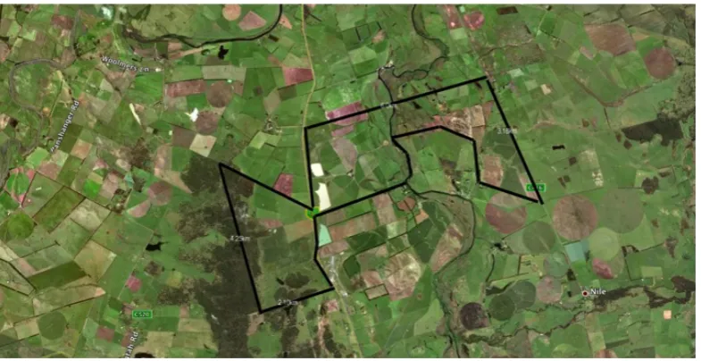
[image:14.595.122.515.323.525.2]serpentine South Esk River, is intersected by the highway and then continues west to the adjoining property on a relatively flat patch of ground in the Midland basin (Fig.1).
Figure 1: Patrick Sutczak, Google Satellite Image detailing Oakdene’s boundary, sourced and digitally drawn 2013.
crossing over at 42 degrees south from the equator - a line that has historically divided Tasmania into the divisions of North and South.
Oakdene was identified as an ideal site for this project due to its diversity of use and features. The property has a variety of distinctive landscape types including riparian land along the river in the east, highly cultivated soils for the production and harvest of crops, grazing paddocks for sheep and at times dairy cattle, as well as large areas of remnant forest. Within the property I found a ‘typical’ Midland landscape with a common aesthetic for the basis of my project.
Jamie Kirkpatrick describes misconceptions of the Midlands when he writes ‘[f]latness, dead and dying eucalypts, gorse, brown pastures, salt –
environmental devastation […] – these are the common impression of those who first travel between Spring Hill and Launceston on the Midland Highway’ (2003, p.45). Kirkpatrick goes on however to relay his impression, an
impression supported by access and time as well as an understanding of the geological, botanical, indigenous and cultural significance of the area itself:
[t]he flatness filled with fog while snow sits on the sun-drenched tiers and white cockatoos scream in the morning, salt pans surrounded by red native grassland, the view of Ben Lomond through sparsely wooded hills while standing by a meandering stream in a valley where colonial plough lines can be seen beneath a species rich native sward, the view from Stacks Bluff on Ben Lomond, seeing the forest open into woodland, and then grassland, on the plains below. Forester kangaroo and eastern quolls in daylight profusion in a hidden valley, the excitement of finding rare herbs, shrubs and orchids in the rough of a golf course, the despair of ongoing bush remnants. The natural paradise that was the Midlands in 1800 hides now largely in its recesses, but it is still there, and deserves both celebration and a future (2003, p.45).
contrasted by the very nature of private ownership and independent agricultural practices – the greater landscape has, and will again, change. John Fraser Hart writes that ‘[t]he rural landscape is constantly changing. It is always in a state of becoming’ (1988, p.381) and this is no more evident than through observations on any single working property. Furthermore, Hart notes that the land is ‘shaped by a host of individual decisions, some great and transformational, most small and incremental in and of themselves’ (1988, p381-382) and it is only through repeat engagement and widespread access that these decisions can be witnessed, and understood as having an effect over time. Agriculture by its very definition is to cultivate the wild lands and to make use of the ground beneath our feet, essentially creating the division between the wild and untamed from the domesticated and useful. Dean notes that ‘[i]t has been through a series of processes, some natural and some of our doing, that the Midlands exists as it is today’ (Dean 2003, p.2). This is commodified and contested land.
The Midlands, for all its visibility, is not traditionally sought after as a
destination for hiking on, or through. The hectares of land are of use, and in use, and without discernible attractions most often associated with hiking (not lessening the value of aesthetic impact itself) the pursuit for access is
uncommon. As a landscape in which to locate my arts research, the
gravitation toward the Midlands was not only for the aesthetic qualities, but for the exploratory opportunities to be present in an environment so often seen but rarely accessed. I wanted to discover the intricacies, histories and traces of human and non-human interactions within a specific agricultural setting.
An open approach to the act of walking in order to discover the catalysts for making was essential for being able to read the landscape as a text - to tease out the narratives presented by place to which a creative response would emerge. This was the process that began with an idea derived from
O’Rourke’s observation that ‘walking protocols’ in contemporary art practice can differ from the established rules of a scientific approach to guidelines and experimentation (2013, p.47) in that an ‘artistic protocol may deliberately leave room for interpretation, thus making it possible for a work to be
executed in more than one way’ (2013, pp.47-48). Without knowing how the act, and art, of walking would render itself into a series of on and off-site works, I began a conversation between myself as walker/maker, and the land as site/text.
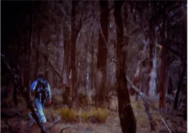
I used walking as a methodology because ‘walking functions as the engine of immersion’ (Conway 1998, p.52) allowing for exposure to nuanced
information during ambulation on Oakdene. Those nuances ranged from human interventions and natural occurrences that shaped the property through traces identified over time from endemic fauna and working animals, to my very presence and movements across the landscape (Fig.2). With the property divided by numerous fences to keep sheep and cattle in, and wild animals out, I recognised the interplay between human and non-human was another source of tension and change within the landscape. Choosing not to focus specifically on the animals, I became interested in segregation and shifts in boundaries.From that came a series of eclectic experiments where I began to identify with the complexities of the property itself along with my approach to making.
My project sought to reach the point of necessary collapse between on-site/off-site experience and representation because through ‘modes of visual representation (of site) […] one cannot feel and therefore cannot truly
understand’ (Tilley, Hamilton & Bender 2000, p.42) the experience of place as I was. Walking became the primary artistic act with the activation of all my senses – ephemeral performances of duration and action, undertaken only by myself. The works and the process of making works off-site became
Figure 2: Patrick Sutczak, West Walk, 2013, digital video still.
The initial process of walking over a period of two weeks early in the project enabled me to construct a sense of familiarity and to identify things, and more importantly locate my self in relation to those things. As I moved across the fields, crossing through the wire fences, climbing over gates, or finding squeezable gaps between fence stays, I formed a mental map whereby I could position myself within the property. A rusty water-trough, a small dam, a fallen tree, a concrete foundation where a shed no longer stood - all these differing objects aided in a primitive form of navigation, and one where walking became both ‘sighting’ and ‘measuring’ as categorised by Jacks in Reimagining Walking: Four Practices (2004, p.5-9).
By walking the land and making rudimentary visual connections of things and the spaces between them I began ‘seeking location and experiencing
dislocation, bringing order to chaos, exploring ratios of scale, charting new terrains’ (Harmon 2009, p.10) while reading the site and generating
knowledge. Mental mapping of the site was not dissimilar from skills
Orientating begins with geography, but it reflects a need of the conscious, self-aware organism for a kind of transcendent orientation that asks not just where I am, but where do I fit in this landscape? (2004, p.15)
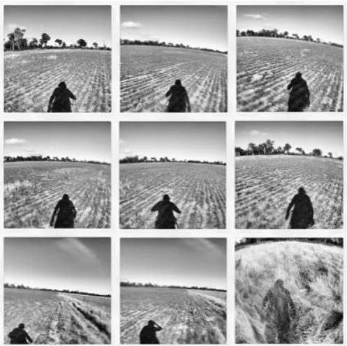
[image:19.595.128.377.380.628.2]And fitting in to the land was an important question to address in my project because of the nature of my wanderings – why walk to, and stop, in the centre of an open field? (Fig.3) The fields have a purpose to them that doesn’t lend itself to durational visitation. Orienteering requires quick assessments of terrain at speed using a relevant map and compass in order to cross over the landscape, locate control points and get to the finish some distance away (IOF, 2015). A field would be considered a geographical obstacle in that sense – a space that would take time to move through. However, my interest was in slowing down in an attempt to remove a variety of possible contexts for engaging with the space and assign a new meaning for being there.
Figure 3: Patrick Sutczak, Across the fields, 2013, digital photographs.
The more I walked, the more Oakdene became a space for contemplative thought that informed works detailed further in this exegesis. Laurene
creation and creating’ (2009, p. 318). While I found this to be true, I also found the walks to be problematic as Vaughan also identifies when she further writes:
[t]here are those (such as the Surrealists, Dadaists and Situationist International) who perceive the actual engagement with space by walking […] to be an act of creating itself. […] This act of creation (like dance or other performances) was temporal and contextual, and existed while being enacted (2009, p.318)
[image:20.595.126.450.440.685.2]The problematic aspect was I found that statement also to be true. Walking quickly became a performance of which I was wholly invested, yet which played to an audience of no one. Recording the walks became necessary as documentation of the act. As I negotiated the project, the question of ‘what was the work?’ arose. I frequently photographed and filmed myself moving across the property (Fig.4) and dual approaches to my work emerged. On-site and off-site became entangled as some walks were conducted and completed as creations themselves. The images and footage became a database of which to draw upon – a resource of my ephemeral activities for the gallery space.
Figure 4: Patrick Sutczak, Walking/Filming, 2013, digital video still.
need for hybrid approaches to considering Oakdene as a text. Considering walking artist Hamish Fulton’s philosophy that a ‘walk has a life of its own and does not need to be materialised into an artwork’ (2014), the project
Navigation
Have I found myself? After the last five days, I’m not only wondering where I am, but who I am. I’m here, but where is here? (Drifting Jimmy in Sheffer R, 2004, p.67)
Gone was the roadside perspective of wire fences converging in the distance to a horizon-point. This perspective of public scenery – where the viewer can look in and is yet denied access – had been superseded by presence and intimacy. Each plot boundary now became a destination that signified a threshold to the next space. Time became a reasonably
accurate measure of distance when walking across grazing pasture due the unimpeded route ahead, with minutes denoting kilometers. Unlike a trail-walk situation, or the block system of a city with its frequent
unpredictability in navigation (not by design, but due to the human/non-human elements that frequent it), the Oakdene landscape was reasonably void of distractions and lent itself to providing not only physical space, but also a psychological space for contemplative thought.
The sense of being in the Midlands landscape suffuses Phillip Wolfhagen’s paintings. Relating to physical presence as a mode of understanding place, Hansen writes:
[f]or Wolfhagen […] conquest is ambiguous, reciprocal. Looking across the gold-dry, irrigation dry Tasmanian Midlands, looking up at the crisp, blue-grey pleats of the Western Tiers, walking and fishing in the wet white clouds up the Ouse and around the Lakes, digging in the productive vegetable garden at home (his half-spoken answer to Monet’s Giverny), the artist is as much in as on (Hansen 2000).
With View to the Past (Fig.5) there is an abstracted familiarity in the dry fields stretching out toward the distant mountain ranges under a large sky. In an image taken from Oakdene looking east (Fig.6), I find a relatable aesthetic to what is depicted in View to the Past. What is notable in both scenes is the sense of scale, vast stretches of land absent of visible boundaries, - the grid system of fences denoting segregation and
ownership. Wolfhagen is quoted in Reid as saying ‘[the Midlands] is not a benign landscape’ (2014)’ and this personal opinion is drawn from intimate and lived experience of the area. Paintings such as Night Vision III
Figure 5: Philip Wolfhagen, View to the Past, 2011, oil and beeswax on linene, 214.5cm x 200.5cm.
Figure 6: Patrick Sutczak, Looking east - site documentation, 2013, digital photograph.
pastures represent space and openness that seemed to reflect those very things within myself. My thoughts loosened and seemed to amble as much as my feet, eventually influencing early text-based visual experiments. In the remnant areas, navigating a way through the space required more attention and the ground underfoot was more reminiscent of a trail hike along a worn path. While the path was not clearly visible in the remnants, a self-appointed waypoint in the near distance acted as one. The density of the remnant forest meant that navigation was at times erratic, and, in stark contrast to the fields, created a way of engaging with the land in a more analytical and challenging way. I identified with Wylie when he writes that ‘the walker in the woods is straightaway, nervously and anxiously, an encompassed self’ (2005, p.238) because of the way in which the remnants are comprised of native eucalyptus species towering above a thick and cluttered understory of weed and fern, that became more invasive over time. There was endlessness to the entanglement of trees and understory shrubs.
By pausing for visual assessment and decision-making, I became aware of the difficulty of simply moving forward, thus generating a degree of
anxiousness. To stop (in the woods), as Wylie further points out, ‘is to be hemmed in’ (ibid.). While feelings of being engulfed by the surrounds had the potential to descend into a need for retreat, my responses were much more aligned with a desire to experience those challenges. Frustrations brought about by back-tracking and re-routing my path, became
experiences directly associated with walking, navigating and making ground in that place, at that time.
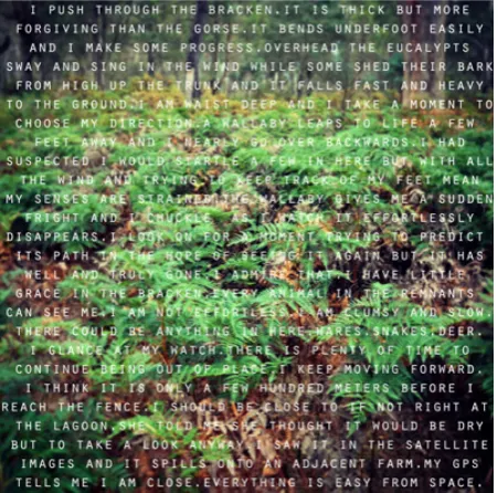
I welcomed these frustrations with one work in particular early in the project as part of my Hopeless Remnantic (2013) exhibition. Titled Everything Is Easy From Space (Fig.7), the work featured a short text overlayed upon an image of remnant forest thick with waist-high bracken fern that I had cumbersomely walked through. The title was suggestive of the pre-walk planning I had done to reach a location on Oakdene identified on Google Satellite imagery (2013). The reality of being physically
Figure 7: Patrick Sutczak, Everything is Easy from Space, 2013, text, digital photograph
Wading through the thick bracken and feeling genuine concerns about the possibility of being confronted by a venomous snake were enough to experience being uncomfortable and subsequently, cautious. Hopeless Remnantic on the whole was about honest responses to Oakdene and superimposing those thoughts through text onto images of the locations in which they occurred. Through the coupling of image and narrative, I wanted the viewer to not only see where I was, but to read something that was an alternative to describing what I saw. These experiments were making visible the ‘density of experience’ (Pearson 2010, p.20) in order to relay a sense of place that could constitute what that place might be like for the unfamiliar in a hybrid of text and image.
Using photography as part of Hopeless Remnantic, it was possible to compose an accurate account of the things that were present in the snapshot composition at the time I was there. Susan Sontag described nature photography as the ‘ecology safari’ (1973, p.11) stating that natural environments are mortal, and subsequently hunted because these
[t]o take a photograph is to participate in another person’s (or thing’s) mortality, vulnerability, mutability. Precisely by slicing out this moment and freezing it, all photographs testify to time’s relentless melt (ibid).
The need to record, to provide or perhaps validate the existence of, with the experience of, became a large part of my relationship with Oakdene and the variable landscapes of pasture and remnant forest within.
Particularly through the months from March in 2013 to November 2013, the walks that I was undertaking were crossing seasons and changes on the property were becoming more evident. On a typical walk of around five to six hours, I was able to traverse the paddocks in isolation and observe the changes created naturally and by human intervention in my absence. Through photography, I could accurately portray the transition of a cultivated paddock awaiting seed to a field of canola blanketed in vibrant green and yellow a month later, Over the period of the project, specific areas of the property (particularly areas of pasture) were changed dramatically to accommodate infrastructure for irrigation, resulting in a mass removal of paddock trees and redefining paddock boundaries. My photographs became documents of visual fact – before and after.
Documenting the walks and assembling a catalogue of images relating to site became important as an evocation of experience after the fact – a memory of a unique Tasmanian landscape that exists as it is at the discretion of the agricultural landowner.
pastures – a form of farming that left the native ecosystems relatively intact (Bush Heritage Australia, 2014)’.
This description is supported by colonial artist John Glover when he described areas of the Midlands landscape as being ‘possible almost everywhere to drive a carriage as easily as in a gentleman’s park in England’ (Smith 1960 in Fensham 1989, p. 37). However, the introduction of European flora and fauna, together with new systems of ownership, and land use caused impacts of the ecology that continue to reverberate.
[image:28.595.141.504.423.664.2]Glover’s depictions of the Midlands through his painting reveal how the appearance of the landscape, its use and its control were deeply entwined. Smith (in Fensham, 1989) describes Glover’s later work depicting his Patterdale property in the Northern Midlands as ‘less picturesque’ and that his paintings ‘relied more upon a clear perception of the characteristic features of the Australian scene’ (p.43). The ‘grassy plains’ and ‘gnarled trunks of ancient gumtrees’ identified by Gilfedder (2003, p.61) as characteristic of the Midlands can be seen in Patterdale landscape with cattle (1833)(Fig.8) in harmony with the addition of livestock.
While truthful as a representation of the Midlands flora, Patterdale landscape with cattle also documents the beginning of the region as it is recognised today – a landscape of cultivation, order and ownership. Beyond the deadfall and standing eucalypts, a building sits quietly and distantly in the composition, smoke from the chimney discreetly carried away by the seasonal breeze – a subtle yet assured reminder that there is an overseer to this scene. The scene here is one of pastoral contentment, where indigenous habitation can be evoked at the safe distance of
nostalgia.
In Tasmania, the forceful eviction of indigenous tradition by Eurocentric principles of ownership, and indeed, inheritance, has seen irreplaceable knowledge of Midland management and resourcefulness lost. Being on the property of Oakdene caused me to consider indigenous heritage as a point of focus – a search for traces of an evicted culture stretching back across millennia. With such rapid change being evident over the past few hundred years in a post-colonised Tasmania, as an artist and researcher on this project, I felt I was contemplating a direction that would only be
problematic with fact-finding and that my interpretations would be fiction and speculation. My focus on a specific period of engagement with the property as it currently stands made me attentive to the rapid pace of change on site as both human and non-human processes altered the environment.
Because of these changes, I used photography as a device for recollection above all else. While walking and navigating, the camera became a basic tool for documenting with composition being a lesser concern than
accessing the data from the image and collating that with GPS data from the specific walk. Changes observed in the landscape could be located, and mapped. This would be the foundation for synthesising
post-experience walking with studio art-making and experimentation. With my work featuring photographs, but not being bound by them, my processes allowed me to break away from the restraints of composition and technical competency, and explore the forms an image could take in order to be indicative of the site at different locations.
gathered from the GPS allowed me to review the walk visually by way of a trail overlay on existing satellite image of the property and surrounds, or in a numerical way through time-based recordings of latitude and longitude, as well as elevation and walking speed (Fig.9). The information is a record that can be read as a true account of the property - how it is negotiated physically. The record of my passage is varying, and speed data alone could be read as an indication that the terrain is difficult to traverse. The line trail overlay serves to further validate that possibility, especially if the line is erratic.
Figure 9: Patrick Sutczak, Garmin Information, 2013, captured computer image
generated an important question. Was a line on a screen an accurate representation of place and experience?Without a visual context such as satellite imagery of the property or photographs, it was difficult to convince myself that it was. The line, though embedded with the physical
undertaking and the history of obtaining it, was still a line that could be transposed to other locations, and potentially hold other meanings
Hamish Fulton’s use of text negotiates the relationship between experience and abstracted representation. In the 2012 retrospective at Ikon Gallery in Birmingham, Fulton presented a series of vinyl text works ‘each with a strong sense of place’ (Ikon Gallery 2012). With a minimalistic approach (Fig.10), Fulton displayed the outcomes of certain walks by way of relaying that he undertook the journey and that that was the work. The record, or the creative documentation, is the secondary outcome of his experiences (Tate 2014). Reminiscent of Person’s model of visitation relating to site-specific performance and ideas relating to occupancy, Fulton’s work falls within ‘[t]hey go there, you and I do not’ (Pearson 2010, p.24) leaving a map for individual experience and a space for new
[image:31.595.140.557.462.665.2]encounters.
While the texts may appear to be a slim outcome of such a long walk, Fulton’s practice of ‘walking as art’ makes the walks ‘analogous to anchors securing larger buoys of thought’ (Tate Modern 2014) and that the
environments that Fulton chooses to locate himself in, or move through, essentially becomes his primary studio of contemplation.
Similarly, I found that space, solitude and walking opened the land up to plentiful opportunities for experiences and potential modes of representing my movements across the land. In many ways, the lines that I began working with on early experiments were accurate in a cartographical sense, but were in need of an accompanying narrative or image to give the line a context to locate it geographically and to create an abstracted map. I began to see myself as a cartographer of my own thoughts relating to time at the site. I felt a sense that introspection was being heightened by space and relative silence and that this was informing my early texts:
Acres and acres of open paddocks yet I move toward the edge. The posts are thin and the wire thinner. Dead straight lines dissecting the land creating a sense of division and order. There are no animals to observe here today but the path is well worn and I fall into line. I kick up small dust clouds from the dry exposed earth. Compacted and tough the grasses on the fringe that have barely taken root on the path appear fragile and temporary in the heat of the late morning sun. I run my fingers along the wire as I go. Smooth and warm I think to myself as I tap upon it and a barely audible ping terminates at the next post along. These are open paddocks now. Neatly kept from grazing I suppose and I wonder what happens next. I am alone and the sound of my boots upon the ground is a strangely pleasing one. It is the sound of progress towards a
head and as I try to shake it another one appears. They fuse and make no sense.
- Follow the Line text from Hopeless Remnantic, 2013
The text alludes to conditions (heat/morning/dry) and also offers
description of objects interacted with (fences/wire) yet leaves out crucial specifics for the reader to be able to locate themselves, leaving only scope for imagination. Without the mention of acres of paddocks however, the text is problematic on its own. Photography was used in conjunction with the text to apply a context and provide an association for a viewer with the site. With text and image combined I attempted to overcome the
limitations of one or the other and find ways to create works more immersive and subjective, than factually descriptive.
Nonetheless, the representation of the property remained fragmented and ‘without some plot to organize the flow of events, everything becomes much harder – even impossible – to understand (Cronon, 1992, p.1351). The only thing connecting the use of text is the site itself. As with
Everything is Easy from Space, the sixteen texts in Hopeless Remnantic are linear individually, but not overall. Through the use of text I noted Cronon’s observations that ‘when we describe human activities within an ecosystem, we seem always to tell stories about them’ (1991, p.1349) yet also remain aware that by using a narrative, however minimal, I was
embellishing the site. A source of influence on my project was a publication created directly from a Midlands Landcare association that spliced
historical and factual information of the Tasmanian Midland flora and fauna with oral histories of landowners who imprinted themselves onto the
Midland fabric. Roger Lockett describes riding his bike in the region as a child and describing his affection and sadness of change.
The place became fascinating to me for its space that then, in turn, informed my creative representational decisions.
I became entangled in the site itself and how I was beginning to portray it. Kenneth R Olwig argues that representation of a place through a
landscape painting is less about nature and scenery, and more about culture (2008, p.162) and a document of social activity and history making. He further states:
[l]andscape painters or poets who make a prospect of a land or country the subject for an artwork or poem are seeking to do more than just reproduce what is before their eyes. They try to capture the more abstract state, quality or “shape” of the place […] because this is what makes them artists practicing the art of place making, rather than surveyors or cartographers (2008, p.163).
Having been exposed to the scenic values of the Midlands for most of my life from the Midland Highway, the allure of becoming intimate through walking and experiencing the landscape was an opportunity to capture the ‘shape’ of the place as Olwig describes. Where as a map in the
cartographical sense is designed to be a topographical and directional tool (such as a road map) ‘maps intrigue us, perhaps none more than those that ignore mapping conventions’ (Harmon, 2004, p10). This then allows my interpretation of a place to be of value artistically and culturally. I wanted to experiment with not what the property was, but what the property could do as I moved across it.
The scenically public yet undeniably private nature of the Tasmanian Midlands means that beyond agricultural purposes, a study of the land’s ‘usefulness’ culturally through public visitation and activity remains largely unexplored. The use of text in my work that runs the risk of ‘being
Experiments and Mapping
He had brought a large map representing the sea, without the vestige of land: And the crew were much pleased when they found it to be a map they could all understand. (Carrol 1876 in Harmon 2002, p.5)
As with Richard Long’s iconic 1967 ALine Made by Walking work (Fig.11) I too walked a line in the grass and photographed the outcome of that action (Fig.12) as an experiment in impermanence and text-making. After spending an hour with the work, I moved on satisfied that the intervention was assertive enough to remain for some time yet confident that the traces of my movements would be reversed by the grass itself. Upon return to the same location a week later using GPS and photographic reference, all evidence of my actions were gone.
Figure 11 (left): Richard Long, A Line Made by Walking, 1967, photograph and graphite on board, 37.5 x 32.4cm.
Figure 12 (right): Patrick Sutczak, Line, 2013, digital photograph.
[image:36.595.140.471.386.583.2]documentation – an opportunity to author a series of texts that detailed the result of my actions. Like Fulton, Long provides scant details of his walk, or performance. A Line Made by Walking for example was presented as a photograph under which Long had handwritten in red graphite pencil A LINE MADE BY WALKING. Below that in grey graphite pencil reads simply ENGLAND 1967 – a fact that assigns a very broad location, and one that also highlights the details as unimportant. What details were provided offered a context, yet Long, while still an art student at the time, was becoming more concerned with finding new ways to work with nature and sculpture through walking and intervention (Burgon 2012).
My line in the grass eventually disappeared, just as Long’s had, but at the time I noted down on a piece of paper that I had ‘created a line by walking but realised I have been doing that the whole time’ (2013). I was referring to the GPS data that was downloaded after each walk and while this was recording my physical path it was only one aspect of the project that I wanted to explore. Those digital lines were permanent but I wanted to continue with interventions and ideas of change, and of identifying and mapping the language of the agricultural landscape.
Using my photograph database as a reference tool, I began isolating themes or points of interest that I hadn’t previously sought. Overlaying GPS data, it was clear that certain paths I had walked were intersecting and sometimes being mirrored. I began to identify with frequency and ‘desire lines’ that I had unintentionally created going from one place to the next over time. I began to discover what was appealing through repeated visitations and how I identified with the land, in terms of negotiating it and returning to things that I would respond to the most. These responses would begin to inform multiple approaches to my mapping of Oakdene. These processes align with the thoughts of Leila Daw when she writes:
things visible that you know, or believe to be there (2008, p.148).
With my work, the things I wanted to make visible was the physical and representational qualities of being there. After Hopeless Remnantic I turned to the GPS data as a visual tool in order to work with lines and with what I was essentially drawing each and every step. The lines themselves were traces of an ephemeral action – a clue to what ‘I was thinking’ as described by Daw (2008, p.148). Walking, back-tracking, revisiting were all evident in post-walk reviews of the GPS information (Fig.13). As my visits to Oakdene increased, so too did the complexity of the lines and the size of my database of information. This information would inform a series of visual investigations around my recorded lines reflecting the idea that ‘to orientate is to hop back and forth between landscape and time, geography and emotion, knowledge and behaviour (Hall 2004, p.15). I started to recognise the multiple possibilities of moving across the land and how these experiences might be realised through studio practice.
[image:38.595.142.416.523.684.2]Taking on-site information, I began extracting sections to work with and couple that with relevant data such as speed and elevation. I began to see these lines as texts that I could easily read as arteries of movement and flow over the property. This led again to introspection and diverted my experiments away from representation into abstraction.
Figure 13: Patrick Sutczak, GPS Walk Data (2013)
experience of ambulation with getting from one area to the next. Like the works of Masaki Fujihata and Esther Polak, I saw my movements as ‘representing the physical terrain as a function of the speed at which it is encountered’ (Mann, Nolan & Wellman in O’Rourke 2013, p.161) and used GPS as a tool for exploratory approaches to mapping, spatial interactions and interpretation. Similarly, Polak uses GPS in her work to create new kinds of documentaries that ‘combine the graphic and narrative
possibilities’ (O’Rourke 2013, p.164) of tracking human landscapes and traces. For Amsterdam RealTime (2002), Polak in collaboration with Jeron Kee and the Waag Society (Fig.14) tracked the movements of 75
volunteers using GPS to create a map that ‘has a distinct look and feel of psychogeographic experience: not precise or rational, but expresses the intuitive and personal aspects of geography’ (Polak & van Bekkum 2015).
Figure 14 (left): Esther Polak & Jeroen Kee, Amsterdam RealTime, 2002, digital image.
Figure 15 (right): Patrick Sutczak, Line 6, 2013, digital image.
There was already a distance in my work between primary and secondary objects. In these experiments I began to consider the digital line
compositions as unresolved because of the information required to support them as secondary objects based on the primary walks. It was in this space that I thought of ‘[v]isitation: going and doing’ (Pearson 2010, p.18) and in particular describing ‘the experience of place and the nature of human occupancy’ (Pearson 2010, p.18) with an observation of ‘I go there and you and they do not’ (Pearson 2010, p.19). The question of
representation was leaning toward abstraction that I felt would be
misunderstood without context. The lines were deliberately stark against black as a suggestion of importance – the line exists. Its exact shape was unique based on my movements across a landscape that offered almost limitless ways to cross it, yet there was nothing that tied the line to the property present in the image.
Inspired by Moore’s concepts of visually pairing back, I began experimenting with expanding the work into a video piece.
As a process to create the images, line data from the GPS was applied to a sphere using the 3D imaging software program Cinema 4D. I then animated the sphere through a series of rotations causing the line to advance in space. This allowed the viewer to see the line reveal itself slowly as it did with my every step in creating it. As an experiment I negotiated ideas around data visualisation, and numerical elements were added to the video work drawn directly from the GPS CSV export data. Overall, this was presented as having three elements: images, video animation, as well as a recreation of CSV export data on an adjacent wall (Fig.16). Any reference to Oakdene as a place was noticeably and
[image:41.595.142.541.443.623.2]deliberately absent, but a necessary investigation (and question) in the limitations (or possibilities) of landscape representation. The work was a trace of physical interaction, as a result of going and doing, again drawing from the theories of Pearson (2010). With the additions, I saw this work as an abstraction and an echo of experience.
Figure 16: Patrick Sutczak, Line Experiment (DATA), installation view, 2013, digital image, digital projection, text
North Carolina, Woods and his team presented a comprehensive
representation of experimental mapping – everything from light omitted by street lights, the local paperboy’s delivery route, house types, wind chimes, to how many pumpkins were present on porches on Halloween. These standalone visualisations made up the greater narrative of the
neighbourhood, one that was subjective and constantly shifting. Blake Butler writes of Woods’ work stating that ‘the more interesting narratives always come out of letting the smaller pieces intuitively […] speak for themselves’ (2013, p.132) and I began to align with that thinking and adopt a similar approach on the project.
Following on from experimenting with lines and keeping in mind the idea of echoes, changes and shifts emerged as a dominant feature of Oakdene, due not only to the expected changes of farming practices but also to the qualities of the flora in the remnant forests. I soon realised that my project was not in any pursuit of achieving a singular point of resolution. Rather, like Woods’ re-telling of Boylan Heights, I thought of the property as having a changing text, writing and re-writing itself in ways that were at times obvious, and other times need to be discovered and observed. With further experimentation and exploration of Oakdene, entropy surfaced as a way of explaining the tensions between human and nature.
Figure 17 (left): Patrick Sutczak, Fields, 2013, digital photograph.
Figure 18 (right): Patrick Sutczak, Remnants, 2013, digital photograph.
I wanted to draw upon these observations and interact with the landscape by creating what became a series of arrangements of branches and deadfall. I named these interventions Orderings. The deadfall, known as ‘coarse woody debris’, is a ‘key structural component […] as a habitat for biodiversity’ (Grove & Meggs 2003 p. 258) and thus an important part of Oakdene if it was to retain a balance of the built and the preserved
environment. I wanted to explore intervention on a small scale and witness the results over consecutive visits as a way of playing with entropy,
[image:43.595.145.460.131.354.2]Through a process of ordering and photographing (Fig.19), these
experiments were necessary for me to further expand my approach to art making and to isolate the legitimacy of the landscape as text. In that sense, to observe the disorder of the natural forest was to read the area in one way, and to introduce intervention was to read something else into it entirely. The remnant forest was busy by nature, aesthetically and physically. The Orderings were a way of moving around in that space of intersection, creating moments of human interaction and establishing a point of difference while allowing for the possibility of an undoing.
Recognising the work of Andy Goldsworthy as a likely point of reference, my Orderings were not to create highly considered (largely ephemeral) structures as a creative end, but be open to reversal and in doing so demonstrate tension in the landscape. Where examples of Goldsworthy’s work ‘replaces the variegated chaos of leaves in the forest […] with a progression from one colour to another’ (Beyst 2002)’ I identified with the approach of the ‘contrasted as found versus created order’ and that ‘the new order is not unnatural as such, it is so only in the given context’ (Beyst 2002)’. In this case the context was the high entropy of the Oakdene
remnant forest.
Upon return to the property a week later, entropy was revealing itself as being a very real force at work, even through my simple experiments (Fig.20). After conducting an act of Ordering, interactions had occurred in my absence to alter structure and rewrite the text I had created. The map, again, was something that was in flux – temporal and temporary. By interacting, positioning, documenting and leaving materials to become undone, my interactions reinforced the fact that ‘(r)ock erodes to sand, cemented sand becomes stone, erodes to sand once again’ (Whiston-Spirn 1998, p.99) highlighting the contested space of Oakdene, the swiftness of change and the site’s ability to engage in its own rewriting.
Figure 20: Patrick Sutczak, Early Orderings Undone, 2013, digital photograph.
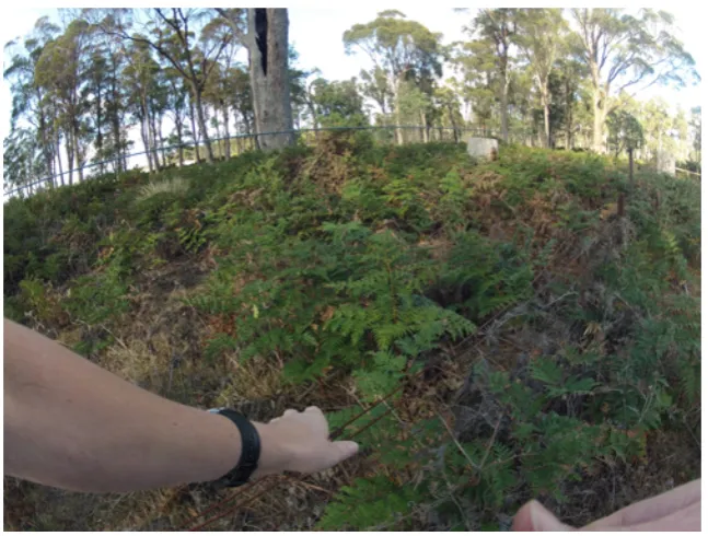
At one location on the property near the south-western boundary I
Figure 21: Patrick Sutczak, Site before Ordering, 2013, digital photograph.
Again, like the other Orderings, I created a series of stacks in the landscape with the intent of returning a week later. The process for gathering and arranging was intimate and took time. The pieces of wood were fixed objects until I arrived at them and initiated intervention with the result being multi-faceted. The GPS line data of my movements were clustered and tight, recording many movements with a fixed period of time contrasting with other data of long lines and distances over kilometers. The objects themselves became small structures that were deliberate and considered in the landscape. Object and action were things that ‘become part of hybrid assemblages: concretions, settings and flows’ (Thrift 2008 in Pearson 2013, p.119).Though my performance of action and ordering did not have an audience, the result of my actions indicated that something by someone, had taken place at some point - there had been an event
[image:46.595.146.381.75.232.2]
Figure 22: Patrick Sutczak, Site after Ordering, 2013, digital photograph.
Again, in my absence entropy was evident. Stacks had collapsed creating new arrangements less precarious that the order of a tower (Fig.23). These works, though a deviation from earlier experiments, again contributed to the cross-section of possibilities within my project. The dynamism of Oakdene promoted new ways of thinking about how the property could be read, how it could be conveyed, and how I would compile experiments and information into a cohesive product.
[image:47.595.145.438.488.685.2]I continued to develop my relationship to the agricultural landscape text in the way that ‘[r]eaders decode meaning, move from perception of an element to an appreciation of its function, to understanding (Whiston-Spirn 1998, p.168)’ and with each visit, my appreciation grew of the complex systems of art and nature. Objects could be the result of actions and movements, but then actions could be objects. As a result photographs and images became the ‘tactic for making new connections and relations visible’ (Woods 2012, p.36) within the project.
While many site visits during 2013 and 2014 yielded a database of photographs, line data and observations, subtle introductions to the property continued to inspire new directions. Filming my walks from a chest mounted camera provided a tangible view of what I was seeing, and sound recordings captured the presence of banjo frogs in wet areas after rain. Scores of white cockatoos screeching in the skies above were
contrasted by the sound of tall grasses buffeted by the winds. I had to keep making, keep visiting and more importantly, keep walking because ‘[a] walk […] has nothing to do with point A, B or getting from one to the other’ (Horowitz 2013, p.21) rather a walk ‘is instead, an investigatory exercise that begins with energy’ (Horowitz 2013, p.21). By walking with energy and drifting around the property, my on-site experiences and off-site contemplations led me to thoughts of containment and the archiving of what I felt was a soft archaeology – of uncovering the ‘complex and interconnected elements that result in the creation of place’ (RMIT Stony Rises Project 2015).
Archiving and Narratives
And when the mind comes to rest, when it ceases its orientating leaps and shunts and associations, we find ourselves back where we started, where Here intersects Now. (Hall 2004, p.19)
Following on from experiments in line and entropy, a walk on the property early 2014 revealed a faint cluster of white dots in the distance some two kilometers away from where I was. As an example of Tom Stone’s philosophies around the drift and physical movements directed by stimuli (Stone 2011, p.1 – 11), I changed course and made a path toward the white dots. As I approached a short while later, it was clear that I was coming upon pallets of bee hives (Fig.24). As I photographed the new introduction in the landscape, I could hear the activity of bees around me, and while keeping some distance, I could see them too – around the boxes, slight in number and no indication of how many bees were actually out in the fields and the remnants. I observed the components of the hives, considered the order not only of the hives themselves, but the way in which they had been delivered. Strapped to the pallets, there was a
suggestion of temporary engagement, and easy transport. Fleeting fixtures to serve a transitory purpose in a time and place.
[image:49.595.143.457.504.715.2]
As I researched beehives, I began to think of archiving as a form of sculpture being derived directly from the components of manufactured beehives. In particular, the components known as Shallow Supers (designed for storing extra honey) and Brood Chambers (living quarters) along with the beeswax frames within (ABJ 2014). With these pieces being compiled to create multistoried factories of activity, I identified with the triangle of insect, human interaction, and product. As objects in the landscape, the hives were immediately recognisable and their purpose and what was contained is a constant association. Having previously seen the work of English artist Alec Finlay at the 18th Biennale of Sydney in 2012, I returned to Finlay’s Swarm (ASX) (2012) as a point of inspiration. Of Swarm (ASX) (Fig.25), Finlay states that:
Swarm (ASX) is an apicultural model of the global financial system. Fluctuations in the stock market
reverberate in the ‘buzz’ of honey-bees broadcast from 10 hives. Each hive bears the acronym of a major world stock exchange. […] Swarm (ASX) is a snapshot of speculative finance translated into the natural ecosystem of bees; dynamic, in flux, undergoing crisis (2015)
Like Finlay and his ongoing work with bees, I related to a found dynamism. Where Finlay found crisis and flux upon the floors of stock exchanges in the likes of New York, Hong Kong, Sao Paulo and Sydney, I wanted my experiments with hives to be a reflection of the shifts, changes and
Figure 25: Alec Finlay, Swarm (ASX), 2012, installation view
My presence on Oakdene and approaches of observation, movement, and documentation had the potential to be explored through a beehive as sculpture/archive. I purchased Shallow Supers, Brood Chambers and frames and began a process of experimentation as objects, and about what form they would take as a work. Each Brood Chamber could hold 8 frames, normally reserved for honeycomb. Pulling apart all the
components, I saw them as pieces representative of the whole – and in this case Oakdene. The property was a myriad of potentialities and spaces in which to draw inspiration – a multiplicity of points to enter, exit and re-enter. In trying to negotiate readings of my work, resolutions and linear representations, I turned to Woods who wrote:
[…] objectivity does not consist in suppressing an
unavoidable subjectivity. It is achieved by acknowledging its intrusion so that the reader is relieved of the necessity of ferreting it out. Besides, nothing obligates a reader to start at the beginning and plow through the complicating actions to the resolution (Woods 2013, p.15)
index of the table of contents or […] letting the atlas fall open where it will’ (2013, p19). Visits to the property and subsequent walks over time had certainly demonstrated that each walk would be, and was, unique in both planning and wilful deviation from thoughts about what would be seen, documented, and interacted with. The beehive as an object provided an opportunity to house the results of activity. Careful not to associate the work with bees directly, I wanted to borrow from the structures and imprint ideas about going, doing, recording and storing – all with the idea of
layering, unpacking and the intersecting of text, landscape and experience.
With the Shallow Supers and Brood Chambers unresolved, disconnected and set aside within the studio, I created a new series of image/text works that were a return to observational introspection and reflection. Taking cues again from Hamish Fulton, I followed a minimal narrative with a series of new works. Fulton’s 1993 series Ten Toes towards the Rainbow has been described as ‘more romantic and pastoral than much of Fulton’s earlier work. Titles such as Song Path evoke his observations and emotions during these long, solitary walks’ (Tate 2004). Creating the works from ten seven-day walks in Scotland’s Cairngorn Mountains, Geese Flying South for example is a purely text-based print that retells moments, and most certainly ones of resonance for the artist. Arranged vertically, Fulton allows space for access and interpretation (Fig.26)
[image:52.595.143.424.505.691.2]
Taking up Fulton’s use of restraint to open space for interpretation, and directly relating to the image (as I had done with Hopeless Remnantic) I relayed what I had observed or experienced:
THE SLAB OF TIMBER APPEARS AS THOUGH IT HAS NEVER BEEN MOVED SINCE THE DAY IT WAS CUT/ SMALL NOTCHES HAVE BEEN ETCHED OUT WITH A CHAINSAW/ I TOUCH THE SILVERED SURFACE CREATED BY TIME AND WEATHER/ SO SOLID I WANT TO TURN IT OVER AND FEEL THE WEIGHT/ I DECIDE TO LEAVE IT ALONE/ IT IS EMBEDDED/ IT IS SETTLED/ IT BELONGS Patrick Sutczak, New Map Series, 2014, text.
Figure 27: Patrick Sutczak, New Maps and Red Texts, 2014, digital print on paper, 21 x 29cm
By encouraging interaction and rearrangement, my personal
interpretations were being re-written within the boundaries of what was there. By walking, pausing, experiencing, reading and writing landscape texts, new narratives from ‘the abstraction of geospatial location and the phenomenon of being there’ (Vaughan 2009, p.319) emerge and the narratives (fixed or arranged) become fluid. Vaughan continues by stating that ‘[i]n this way, the view of the map, the position of the viewer, the level of detail or clarity, and the poetics of interpretation, become part of the description of place’ (Vaughan 2009, p.319)’. This is consistent to the layers visible on Oakdene: its tensions, shifts and changing landscape texts. For example, a Red Text relating to an open pit discovered on a 2013 Oakdene walk:
OPEN PIT DISCARDED
YET TO BE BURIED SPRING RAIN 2013
Patrick Sutczak, Red Text Series, 2014, text.
That text was in direct relation to an open pit (Fig.28), first encountered in the summer and then happened upon again a wet spring day. Filled with water, and with unusable materials and rubbish, the pit was soon to be filled in and all traces of it gone. Paired with a New Map, layers of
[image:55.595.141.410.335.508.2]experience and of human action are suggested, Removed from its parent Map, the texts take on a non-linear aspect.
Figure 28: Patrick Sutczak, Site Documentation: Pit, 2013, digital photograph.
As the New Maps and Red Texts developed, I returned to the Shallow Supers and Brood Chambers to create places of intersecting, and moveable archives. I began to see the potential of the hives as shifting sculptures and cabinets potentially storing the map of Oakdene in a fragmented form; all within the box but by no means defined. Artist and maker of objects Patrick Hall says that ‘[t]he cabinet can be seen as a metaphor for the 20th century […] it is filled with storage and classification systems, […] the keep-sakes of everyday life and the ephemera of
of the cabinet and the archives it contains suggest the ways in which these collections can be cumulative and unstable.
Within my boxes, I set out to have my histories of Oakdene engagement become interactive. Replacing what would normally be an artificial
[image:56.595.140.333.247.500.2]honeycomb plate, I used eight sheets of clear acrylic as transparent layers onto which I inscribed walk data in ink (Fig.29). With fragmentation and rearrangement in mind, I traced only sections of data from 2013 and 2014.
Figure 29: Patrick Sutczak, Documentation: Hive in progress, 2014, digital photograph.
With each Shallow Super able to hold eight frames, I created a multi-layered map of data that could be rearranged creating new points of
intersection across multiple boxes. Atop of each frame I punched four short narratives into the wood which, like the texts of the New Maps and Red Texts, were linear in one arrangement but would create new stories generated through action, movement and placement.