This is a repository copy of The AVTUNE Noise Model.
White Rose Research Online URL for this paper: http://eprints.whiterose.ac.uk/2497/
Conference or Workshop Item:
Goodman, P., Bell, M. and Hodges, N. (2002) The AVTUNE Noise Model. In: 11th. International Symposium on Transport and Air Pollution,, 2002, Graz, Austria. (Unpublished)
[email protected] https://eprints.whiterose.ac.uk/ Reuse
See Attached
Takedown
If you consider content in White Rose Research Online to be in breach of UK law, please notify us by
Universities of Leeds, Sheffield and York
http://eprints.whiterose.ac.uk/
Institute of Transport Studies
University of Leeds
This is an author produced version of a paper given at the 11th. International Symposium on Transport and Air Pollution. Copyright held by the authors and the Institute of Transport Studies, University of Leeds.
White Rose Repository URL for this paper: http://eprints.whiterose.ac.uk/2497
Published paper
Goodman, P., Bell, M., Hodges, N. (2002) The AVTUNE Noise Model, presented at 11th. International Symposium on Transport and Air Pollution, Graz, Austria
THE AVTUNE NOISE MODEL
Paul Goodman, Margaret C. Bell Institute for Transport Studies,
University of Leeds, Leeds UK
Nicholas Hodges Leicester City Council,
Leicester UK
ABSTRACT
This article briefly describes the implementation of a new road traffic noise prediction facility, AVTUNE (Airviro Traffic and Urban Noise Evaluator) within the framework of the existing Airviro pollution management system. The joint noise and air quality modelling system forms a major component of the Leicester element of the European Union Fifth Framework project, HEAVEN (Healthier Environment through the Abatement of Vehicle Emissions and Noise).
The noise model itself has been broken down into two major components: the SNEM (Source Noise Emissions Module) that works in quasi real-time and compliments the Airviro system’s ability to acquire directly from Leicester’s UTC (Urban Traffic Control) centre in predicting pollutant emissions, and the SPM (Sound Propagation Module) that provides additional long-term prediction and noise mapping facilities outside of the real time framework.
At the time of writing, the model has just completed a validation exercise covering a section of Leicester’s road network. Initial results from this exercise are presented here. A larger demonstration exercise is planned to run throughout the Summer of 2002.
Keywords: urban traffic control, decision support systems, noise modelling, noise mapping, emissions modelling
1. INTRODUCTION
The European Union Fifth Framework HEAVEN project has as its main goal the development of a Decision Support System (DSS) that will allow partner cities (Berlin, Leicester, Paris, Prague, Rome Rotterdam) to:
• provide a better description, in quasi real-time, of the environmental impacts (on air and/or noise) mainly induced by traffic and,
• assist in identifying TDMS (Traffic Demand Management Strategies) that reduce the impact of traffic on the environment.
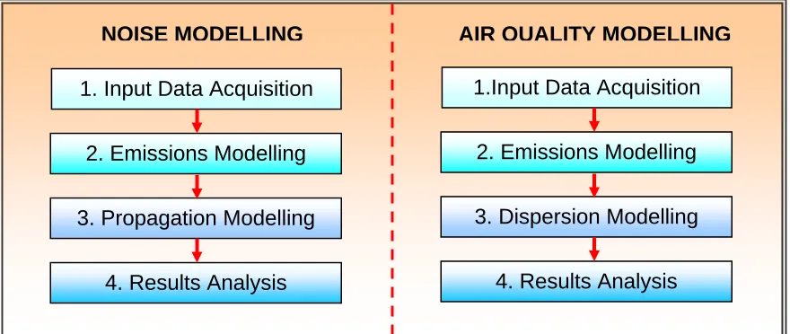
Given that the stages of noise modelling are almost directly analogous (see Figure 1) to those involved in air quality modelling all components required for traffic noise modelling in Leicester are being incorporated into the Airviro system.
1. Input Data Acquisition
2. Emissions Modelling
3. Propagation Modelling
4. Results Analysis
NOISE MODELLING AIR QUALITY MODELLING
1.Input Data Acquisition
2. Emissions Modelling
3. Dispersion Modelling
[image:4.595.77.517.122.308.2]4. Results Analysis
Figure 1: Stages in Noise and Air Quality Modelling
2. THE MODELLING PROCESS
The four stages (Figure 1) involved in the modelling process are handled by various components of the Airviro system. Two of these components, termed the SNEM (Source Noise Emissions Module – handling Stage 2 in Figure 1) and the SPM (Sound Propagation Module – handling Stage 3 in Figure 1) are completely unique to the Leicester Airviro system. The other modelling stages are handled by modifications to existing Airviro components.
2.1 Stage 1: Input Data Acquisition
The data input may be divided into two categories, data required for the SNEM and the data required for the SPM.
For the SNEM, data requirements include:
• Traffic network information: i.e. the spatial coordinates of road links.
• Traffic data: e.g. flow levels, flow speeds, proportion of heavy vehicles etc.
Traffic data may be provided either as static information, entered manually through Airviro’s GUI (Graphical User Interface) or dynamically through a link to Leicester’s SCOOT (Split Cycle Offset Optimisation Technique) system (Hunt et al, 1982). The SCOOT data provides flow counts from on-street detectors, as well as journey times and estimates of the delay to vehicles due to traffic signals. From this additional data average link speeds may be calculated. If SCOOT information is unavailable, flow levels and speeds on links may be provided from a calibrated standard traffic assignment model, TRIPS.
For the SPM, data requirements include:
• Topographical data: i.e. spot heights, benchmarks and/or Digital Terrain Model (DTM) data.
• Soft ground areas: i.e. grassland, cultivated or wooded areas.
• Land use data: e.g. commercial, residential, recreational areas.
• Meteorological data: i.e wind direction and speed, temperature etc.
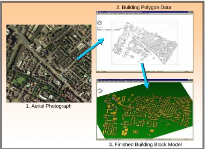
The first three datasets may be found within the standard Airviro system, but a far too crude a level to be of use in sound propagation modelling. Hence additional data needs to be manually input through a GUI or extracted from appropriate data sources (e.g. the use of OS LandLine 1:1250 map tiles and aerial photography to generate building polygon data – see Figure 2).
For meteorological data Airviro’s own time series data, gathered live from a met mast within the City may be used to provide average meteorological conditions to the SPM.
1. Aerial Photograph
2. Building Polygon Data
[image:5.595.86.495.243.540.2]3. Finished Building Block Model
Figure 2: Building data acquisition from Aerial photography
2.2 The Source Noise Emissions Module
The source noise emissions module may work either online in real-time, using SCOOT data to predict traffic noise levels every hour, throughout the day, or offline using previously stored or manually input traffic data.
At the present time link based emissions levels may be calculated using one of two national standards:
• Calculation of Road Traffic Noise (CoRTN), UK (DoT. 1988).
The actual noise level calculated is either equivalent power of sound emission per unit length (dB/m) along a link. For the UK standard this involves conversion from an LA10 emission
level at a given distance from the road.
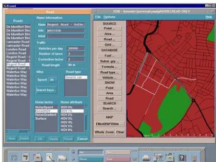
[image:6.595.188.408.165.330.2]A separate Airviro Edb is updated and maintained for each of the emissions models used. The Airviro GUI for the SNEM is shown in Figure 3.
Figure 3: The AVTUNE SNEM User Interface
2.3 Stage 3: The Sound Propagation Module
The sound propagation module works by using the principle of inverse acoustic ray tracing. This procedure involves the casting of rays, representing the paths of sound wave fronts, from a defined receiver location backwards towards potential source objects. As a ray travels it may be specularly reflected from or diffracted around building/barrier objects, creating further ray paths for consideration. If a ray intercepts a source point or line, then attenuation from all factors along the ray path is calculated, deducted from the source level, and the contribution of the final calculation added to the current noise level at the receiver.
At the present time the levels of attenuation are calculated in accordance with ISO 9613-2: Attenuation of sound during propagation outdoors, Part 2: General method of calculation (ISO, 1996).
Given the computationally intensive nature of the ray-tracing operations the SPM is not run in real time. Large areas are modelled by being broken down into in smaller, overlapping tiles. Receivers may be positioned at single points, or as vertical or horizontal grids. The LAeq, 1-hour
level is the primary parameter modelled. Post-processing may be used to convert calculated LAeq levels into Lday, Levening, Lnight or LDEN parameters in accordance with the new European Commission Directives on Ambient Noise.
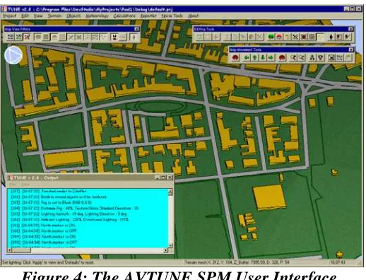
Figure 4: The AVTUNE SPM User Interface
2.4 Stage 4: Analysis of Results
This stage is still under development at the current time. Output, analysis and presentation of results will be generally be through using existing facilities in Airviro, including a presentation graphing modules, raster, grid and contour mapping. Data will also be exported for import into GIS systems. Additionally it is the intention of the HEAVEN project to make data available to City Council Staff and the General public through the internet.
3. Present and Future Work
At the time of writing the verification phase of the HEAVEN project has just been completed. Modelled values from the AVTUNE SNEM & SPM using dynamic traffic data and the modified CoRTN procedure have been compared to nearby façade LAeq, 1-hour measurements
around the London Road/Regent Road area of Leicester. A regression analysis of some of these initial results may be seen in Figure 5. Error bars show ±2dB(A) tolerances.
The HEAVEN project enters its demonstration phase during Summer 2002 and is scheduled to finish in early 2003. The demonstration area chosen is the Narborough Road corridor in South-West Leicester, leading from the M1 motorway towards Leicester City Centre. The environmental effects of various TDMS strategies, such as speed or HGV reductions within this area will also be considered.
Figure 5: Results from initial AVTUNE SNEM/SPM verification surveys
ACKNOWLEDGMENTS
The work outlined in this article would not have been possible without the assistance of Leicester City Council Area Traffic Control and the Instrumented City Facility, University of Leeds in providing the required traffic data and the Swedish Meteorological and Hydrological Institute for assistance in the production of the required software components.
Aerial photography and data extraction were provided by Infoterra, UK.
REFERENCES
Hunt, P.B., Robertson, D.I., Bretheron, R.D & Winton, R.I. (1981) SCOOT – A traffic
responsive method of co-ordinating signals. TRRL Laboratory Report 1014, Transport and
Road Research Laboratory, Crowthorne, Berkshire.
DoT (Department of Transport) (1988). Calculation of Road Traffic Noise. Department of Transport – Welsh Office. HMSO, London
CERTU (1996). Bruit Des Infrastructures Routières, Méthode de calcul incluant les effets
météorologiques. Version expérimentale. NMPB - Routes – 96. Centre d’études sur les
Réseaux, les Transports, l’Urbanisme et les Constructions Publiques,Lyons, France
ISO (1996). Acoustics – Attenuation of sound during propagation outdoors – Part 2: General
Method of Calculation. ISO 9613: 1996(E), International Organisation for Standardisation,
Geneva, Switzerland.