This is a repository copy of Achieving genuinely dynamic road user charging: Issues with a GNSS-based approach.
White Rose Research Online URL for this paper: http://eprints.whiterose.ac.uk/101805/
Version: Accepted Version
Article:
Velaga, NR and Pangbourne, K orcid.org/0000-0003-2100-1961 (2014) Achieving genuinely dynamic road user charging: Issues with a GNSS-based approach. Journal of Transport Geography, 34. pp. 243-253. ISSN 0966-6923
https://doi.org/10.1016/j.jtrangeo.2013.09.013
© 2013, Elsevier. Licensed under the Creative Commons Attribution-NonCommercial-NoDerivatives 4.0 International http://creativecommons.org/licenses/by-nc-nd/4.0/
[email protected] https://eprints.whiterose.ac.uk/ Reuse
Unless indicated otherwise, fulltext items are protected by copyright with all rights reserved. The copyright exception in section 29 of the Copyright, Designs and Patents Act 1988 allows the making of a single copy solely for the purpose of non-commercial research or private study within the limits of fair dealing. The publisher or other rights-holder may allow further reproduction and re-use of this version - refer to the White Rose Research Online record for this item. Where records identify the publisher as the copyright holder, users can verify any specific terms of use on the publisher’s website.
Takedown
If you consider content in White Rose Research Online to be in breach of UK law, please notify us by
1
Final paper submitted to Journal of Transport Geography after peer-review.
Published as: Achieving genuinely dynamic road user charging: issues with a GNSS-based approach
Village, N. & Pangbourne, K. Jan 2014 In : Journal of Transport Geography. 34, p. 243-253 11 p.
http://dx.doi.org/10.1016/j.jtrangeo.2013.09.013
Achieving genuinely dynamic road user charging: issues with a
GNSS-based approach
Nagendra R Velaga*a and Kate Pangbourne†
*Assistant professor, Transportation Systems Engineering, Civil Engineering Department, Indian Institute of Technology (IIT) Bombay, Powai, Mumbai, India-400 076.
†Research Fellow, Centre for Transport Research, Geography and Environment, University of Aberdeen.
a Corresponding author: [email protected] Phone: (0091) 222576 7341. Abstract:
A variety of approaches to road user charging (RUC) for reducing congestion and raising revenue to maintain and improve transport infrastructure is in place in many countries; examples of such RUC include: an Electronic Fee Collection System in Singapore, Cordon Pricing in Oslo City in Norway, Zoned Based Pricing in London and Distance-Based Pricing for heavy lorries in Germany and Switzerland. No RUC system is fully comprehensive and applied to all users across
a state’s road network, but there is increasing awareness that revenues from fuel-based taxes are dropping with continued improvements to engine efficiency. The development of satellite technologies in tandem with in-vehicle telematics makes the introduction of universal dynamic pricing feasible and provides an unrivalled opportunity for RUC to incorporate external costs and apply socially inclusive measures to pricing whilst also providing price cues and behavioural feedback for travellers to adopt more efficient vehicle technologies and/or driving styles, or to switch modes. This paper provides critical and comparative assessments of existing road user charging (RUC) systems with reference to technological limitations and acceptability issues. The paper then goes on to demonstrate a system architecture for a Global Navigation Satellite System (GNSS) based dynamic RUC system capable of incorporating such a comprehensive approach to pricing and behaviour. Finally, we consider the feasibility of the proposed system in relation to technology readiness and public acceptability. We highlight some of the potential wider benefits from the introduction of a comprehensive system that could justify the cost of development and implementation as well as improving public and political acceptability. The paper ends with conclusions and future research directions.
Key words: Polluter Pays Principle, road user charging, GNSS, GIS, acceptability.
2
This paper focuses on a proposed GNSS-based road user charging (RUC) system capable of incorporating environmental and social equity in pricing for road use. The building and maintenance of road infrastructure has to be paid for. Though roads are often funded out of general taxation in recognition of the general public benefit that arises from the network, many governments have also introduced vehicle registration taxes and duties on fuel. RUC has not yet been applied comprehensively anywhere in the world. However, point-of-use charges long pre-date the use of general taxes to pay for infrastructure. A variety of such direct RUCs are in operation around the world. For example, the Electronic Fee Collection System in Singapore, Cordon Pricing in Oslo, Norway, Zoned Based Pricing in London and Distance-Based Pricing in Germany and Switzerland (Ison and Rye, 2005; Richardson and Bae, 2008; Palma and Lindsey, 2011). Many systems are in urban areas and intended to tackle congestion problems though revenue raising is also an objective, which is in tension with environmental and economic efficiency arguments for RUC introduction (May and Milne, 2000).
At present no existing RUC system is fully comprehensive across a nation state network, but there is increasing political awareness that revenue from fuel-based taxes is dropping with continued improvements to engine efficiency (Glaister, 2010; Johnson et al, 2012; Duncan and Graham, 2013). This is a difficulty for governments that rely on fuel-based taxes to boost general tax revenue whilst suppressing transport demand. Furthermore, serious congestion continues to be a problem in both the developed and developing countries of the world, with associated air quality and human health problems. Financing new infrastructure and maintenance of existing networks is also a significant problem.
2. Background and research objectives
The air quality problems referred to above, as well as the other negative environmental impacts of
road transport are ‘externalities’, as they are currently not compensated for in existing taxes paid by road users. In 1972 OECD member countries agreed to apply the Polluter Pays Principle (PPP) to their environmental policies (World Commission on Environment and Development, 1987). In spite of the environmental justifications sometimes applied to the imposition of additional tax on vehicle fuel, none of the existing examples of systems for collecting fees from road users fully assimilates the tenets of PPP, under which vehicles that cause more road damage, and higher marginal social costs from negative externalities such as congestion and pollution, should pay more. The desirability of applying the PPP to RUC was first highlighted in the early 1960s. A panel supported by Ministry of Transport, UK and chaired by Professor R. J. Smeed prepared guidelines for implementing a successful charging scheme at national level (Smeed, 1964). The Smeed Report concluded that RUC should be dynamic spatially, temporally and modally, and the level of charges should closely approximate the amount of road usage (i.e. to reflect the differential wear and tear caused to roads by different types of vehicle), congestion and environmental pollution caused by a vehicle.
3
national-level dynamic RUC, they stipulate that for technical and economic feasibility, the
variables should be “readily and accurately measurable”, varying in direct proportion to the
amount of road use and its associated environmental and social impact. They also assess vehicle location systems and sensors (e.g., vehicle emission monitoring unit) for GNSS-based dynamic RUC. They note additionally that RUC schemes should be transparent and easy for users to understand whilst being flexible enough for operators to address multiple policy aims.
That charges for road use should more closely reflect impacts on infrastructure and negative externalities has been apparent in European policy circles since the publication of a European Commission Green Paper (CEC, 1995). Direct RUC is a rational means to address the issue of funding road infrastructure and addressing environmental problems identified and can be designed to be socially just. The European Community (EC) is also seeking to ensure that the variety of technologies currently used for forms of RUC in the EC should be interoperable, utilising new opportunities in satellite positioning and mobile communications (Directive 2004/52/EC).
In this paper, the necessary architecture for a Global Navigation Satellite System (GNSS) based dynamic RUC system is demonstrated. Developed through the application of computer science techniques the proposed system incorporates dynamic journey related variables that would meet the requirements of government/operators, PPP and social equity, such as distance travelled, road class, geographic area (e.g., urban, semi-urban or rural), time of trip, road network conditions (e.g., congestion level), driver characteristics (e.g., tendencies to speed, brake hard or suddenly accelerate), and vehicle occupancy level, as well as vehicle dependent factors like vehicle class and pollutant emissions. Together, these variables determine the RUC applied to each trip. The paper also demonstrates a number of important technical aspects which are not presented in literature together (e.g., technology issues with GNSS system, GIS maps and algorithms). Finally, we address the feasibility of implementation of the proposed dynamic road user charging system, considered from the twin perspectives of technology readiness and acceptability (drawing primarily on UK evidence) and we offer some conclusions about the potential benefits arising from the data that this system would generate and key areas for future research.
The latest advances in transport telematics that utilise a range of advanced ICT, vehicle sensing, emission monitoring, digital technologies, and navigation and positioning systems may help in deploying such a national-level dynamic RUC system (Sussman, 2005; Deeter, 2009; Velaga et al., 2012a). Whilst the cost of the individual technologies required has now fallen substantially, critical factors for implementation are public and political acceptability as well as the transition costs of an entirely new system for charging road users (see for example, Schade and Schlag, 2003, or Kocak et al., 2005). However, the main objectives of this paper are: (1) to review existing charging types and technologies to develop a critical comparative assessment of RUC types and technologies; (2) to demonstrate the system architecture for a national GNSS-based fully dynamic RUC system; and (3) to describe issues of technological readiness, and reflect on public and political acceptability issues with the proposed GNSS based dynamic RUC.
4
There are broadly two types of pricing: (1) fixed and (2) variable (Cottingham et al., 2007; Palma and Lindsey, 2011). Fixed charges apply a flat fee for making a journey of any length on a chargeable road. Fixed charges can also be applied for driving within a chargeable area. Variable charges are more dynamic, e.g. varying by distance travelled on a chargeable road (Grush and Roth, 2008) or time within a controlled zone. Without highly sophisticated locative technologies, however, there is scope for only a very small amount of distance-based variation (e.g., in the case of the M6 Toll in the UK, all the local toll plazas are priced the same, slightly cheaper than the Main toll plaza, and thus leaving the motorway at the first exit is the same price as leaving it at the fifth exit, though cheaper than travelling the full length of the tolled road segment1).
There are also different systems for applying charges: (1) single point charging at a tollgate, e.g. for toll roads, bridges and tunnels (2) area-based charging within certain boundaries, e.g. in congested urban areas, and (3) distance based charging systems, in which users are charged when leaving tolled routes or with more technological sophistication, remotely invoiced for the exact distance travelled on chargeable routes within the system. Several technologies are available, often combined in unique ways for each system in operation. For example Radio Frequency Identification (RFID) tags can be used on the M6 Toll road in the UK in addition to less technological approaches; Automatic Number Plate Recognition (ANPR) cameras are used for the London Congestion Charge (UK); and GPS2 is used for distance-based RUC in Germany and Switzerland.
3.1 Single-route point charging
A single-route point charging system imposes charges to use a piece of transport infrastructure, such as a road, tunnel or bridge, usually based on vehicle class, and applied at a tollgate (Goh, 2002). The rationale for the toll is usually to pay for a particular piece of infrastructure construction and maintenance, and the concept does not depend on advanced technology. In manual systems, vehicles stop at a tollgate to pay an attendant (e.g., the National Highway-5 toll system, India). Drawbacks such as long vehicle queues at toll stations at peak hours (Komada and Nagatani, 2010), high operating cost, and extensive space requirements for physical infrastructure, provide incentives to improve toll collection technology. A moderate application of technology reduces the need for human attendants (e.g., coin baskets for cash payments and a contact-less card reader for card holders are both used on the Clifton Suspension Bridge, UK3), but the principle drawback of traffic delay remains as vehicles must slow down substantially. Innovation is driven to achieve the objective of uninterrupted vehicle movement, leading to developments such as Electronic Toll Collection (ETC) (Hau, 1990; Slovak Republic, 2010)..
In an ETC system the fee is transferred electronically from vehicles passing through the tollgate to the toll agency. The introduction of this type of system enabled vehicles to pass tollgates at up to 60 km per hour (Hau, 1992; Ardekani, 1991), though much higher speeds are now possible. ETC
1 See URL http://www.m6toll.co.uk/pricing/pricing-guide/, last accessed 8th October 2012
2 GPS is the commonly used acronym for all satellite-based navigation systems. Technically, it only applies to systems using the satellites of the USA’s military Global Positioning System, now that other satellite systems are
available that enable satellite-based navigation. In this paper we use GPS primarily in its common sense.
5
systems require three primary elements, as shown in Figure 1: (1) a process of vehicle identification (e.g., using Radio-Frequency identification to link the vehicle with its owner); (2) vehicle classification (e.g., using loop detector and video image processing to identify vehicle class); and (3) transaction processing between vehicle owner and charging authority. These developments are often applied in addition to existing methods of toll collection (e.g., the privately operated M6 Toll (UK) applies multiple technologies at Toll Plazas: vehicles either stop to pay an attendant, slow down to use a coin-basket or drive through with a RFID tag)
[Figure 1 near here]
3.2 Area Based Road Charging
Area-Based Road Charging (ABRC) involves charging to use roads in designated areas and is generally used for demand-management in congestion hotspots, hence is often known as
‘congestion charging’. There are three main types of ABRC: (1) Area Licensing Scheme, (2)
Cordon Pricing (or ‘toll ring’), and (3) Zone Based Pricing.
An Area Licence Scheme (ALS) is low tech: a driver purchases a special supplementary licence, and displays it on a vehicle driven within the charging zone during applicable hours. From 1975 to late 1990s, Singapore operated an ALS to address traffic congestion in the central business district (Santos, 2005; Cottingham et al., 2007). The system was upgraded to a cordon-based ETC pricing system in 1998, becoming the first example of electronic road pricing for congestion management (Goh, 2002; Olszewski and Xie, 2005). In cordon-pricing, vehicles are charged when they cross the designated boundary line of a chargeable zone (usually a city centre) (Maruyama and Sumalee, 2007; Shepherd et al., 2008). This approach can be low-tech, but many current examples are electronic. Norway’s first toll cordon was introduced in Bergen in 1986. A second scheme was introduced to the capital city Oslo in 1990 with 19 toll stations, operating 24 hours a day. The main drawback is that under cordon-pricing, road users can travel free within the cordon and some schemes, such as Oslo, do not charge outward movements. In zone-based pricing, all vehicle users driving within the boundaries of a chargeable zone should pay the user charges. Essentially, zone-based pricing is a technologically advanced form of an ALS. of the London Congestion Charge is a zone-based pricing scheme, and uses ANPR (see Figure 2) (Santos and Fraser, 2006; Santos, 2008). However, several disadvantages with the technology, such as need to install and maintain roadside physical infrastructure, low accuracy in poor weather and similarities between letters and numbers causing ambiguity, as well as high enforcement costs suggest a need for further technological innovation.
[Figure 2 near here]
3.3 Distance-Based Toll collection
distance-6
based RUC for such vehicles when the technology became available. In January 2001, Switzerland introduced DBP for goods vehicles carrying over 3.5 tonnes on all public roads. The Swiss system combines three variables: distance travelled, highest authorised weight and vehicle emission class. Distance is measured using tachograph, coupled with a GPS and a movement sensor to ensure the tachograph signal is not tampered with. Germany introduced DBP for heavy goods vehicles (HGV) in January 2005. Here, freight vehicles weighing over 12 tonnes driving on motorways are charged based on distance travelled, number of axles and vehicle emission class (Hensher and Puckett, 2005; Broaddus and Gertz, 2008). The German system utilises a GPS and positioning sensor in an On-Board Unit (OBU) to automatically track vehicle position, calculate distance travelled and apply the appropriate fee. The Czech Republic introduced DBP for vehicles over 3.5 tonnes in 2007, using an OBU, with charges automatically applied on the basis of passing under over-head gantries on chargeable roads (see www.rapptrans.nl).
4. Critique of Existing and Proposed RUC
4.1 Comparative Assessment of RUC types and technologies
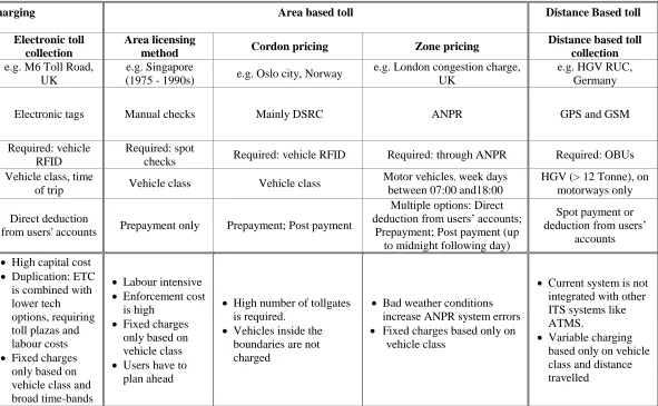
In order to clarify the benefits of our proposed GNSS-based RUC architecture, we sought information about a number of existing RUC systems in operation in Europe and elsewhere. In Table 1 we summarise the main features of examples that illustrate the technological development across the range of RUC types and examples we identify above. From this we conclude that most existing types of point and area-based RUC systems are fixed charge types based on class of vehicle and time of trip. Therefore most current RUC systems do not directly apply the PPP based on amount of road use, road damage and environmental pollution, whether the stated aim is revenue raising or traffic management. Also most of the more dynamic systems are only aimed at one part of society, e.g. businesses using HGVs, which reduces fairness. Higher technology systems address traffic flow disadvantages and enforcement issues, and can introduce more parameters for pricing variability (e.g. Singapore’s ETC reflects traffic conditions at the location where the user enters the zone). Whilst a distance-based electronic RUC mechanism does consider the distance travelled on a chargeable road as well as vehicle characteristics for freight vehicles, other variable parameters like road class, congestion level, or time of the trip, are not considered.
[Table 1 near here]
4.2 Public and Political Acceptability: the UK example
7
there are only two examples of urban congestion charging in the UK - a single street in Durham (introduced in 2002) and the London Congestion Charge (introduced in 2003). Two other major schemes (Edinburgh and Manchester) were abandoned following local referenda (in 2005 and 2008 respectively) and, in December 2006, there were 1.8 million signatures to a government e-petition website against introducing national RUC in the UK (Glaister, 2010).
The literature on public acceptability of RUC identifies some key elements. Fairness in system design is one important factor. For example, in the case of the abandoned Edinburgh congestion change, the objectives of the scheme were to reduce congestion within the city and to raise revenue for transport infrastructure projects and public transport subsidy. The system that was proposed was an area-based toll based on inner and outer cordons, utilising ANPR technology at the cordon. However, there would be no charge for drivers within the area who did not cross a cordon. Rye et al., (2008) suggest that this was politically motivated, as most Edinburgh residents (i.e. voters) would effectively not have to pay the charge unless they crossed the inner cordon. However, it should be acknowledged that this design decision also reflects the higher installation costs involved with zone-pricing, which requires comprehensive installation of ANPR cameras throughout the zone, not just at boundary crossings. Whilst in-bound commuters from neighbouring local authorities would have a motive to find an alternative mode of travel or pay the charge, Edinburgh residents would have little incentive to stop contributing to congestion. As the referendum only took place in Edinburgh it is somewhat surprising that there was so much opposition to it, though there was a well-orchestrated ‘No’ media campaign (see Conclusions below).
Research generally shows that acceptability has been the principal barrier to implementing RUC of various types in several different countries. For example, Kocak et al (2005) reports a series of European surveys in which public support for RUC is generally lower than 30%. However, Ryley (ibid) points out that whilst scheme acceptability generally falls before implementation, post introduction acceptability rises when a scheme is proven effective. The introduction of RUC in 2006 for Stockholm, Sweden, was achieved by introducing a 6 month trial period prior to a public vote. Having directly demonstrated the benefits of congestion charging, the vote was positive and permanent city congestion charging was established in 2007. Over the longer term, the congestion reduction benefits of RUC for Stockholm have been maintained, in spite of a real terms reduction in the cost of average journeys inside the RUC zone, and public acceptability as increased to 70% (Borjesson et al, 2012).
5. GNSS-Based RUC
Technology has advanced to such a point that it should be possible to address some of the public and hence political, acceptability issues that relate to scheme design when considering ‘whole
nation’ RUC rather than more bounded zones. There is also a case to better apply the PPP. Here, we set out the system architecture that would be required for a genuinely dynamic RUC system in which vehicles that cause more road damage and higher marginal social costs from negative externalities such as congestion and pollution, pay more. Moreover, dynamic RUC systems offer
8
times of day, or who use less congested routes (Tillema et al., 2013). In the next section we describe the architecture of a GNSS-based system capable of including the variables that would enable individual drivers to see the cost impact of their decisions and to calculate how to make cheaper journeys (i.e. choose different routes, times or modes) whilst simultaneously enabling traffic authorities to give clear price signals to manage congestion and emissions levels and potentially include the real-time data on traffic in intelligent transport systems (ITS) for management of signals and variable message signs.
5.1 Proposed GNSS-based Dynamic RUC system architecture
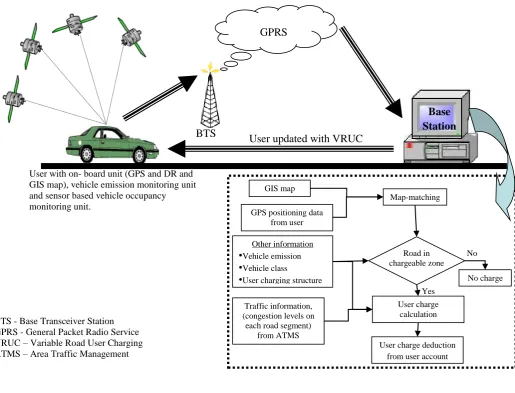
The components of a PPP compliant GNSS-based dynamic RUC system are: an OBU (equipped with a GPS and a Dead-Reckoning (DR) sensor), a wireless communication system (e.g., DSRC, GSMC, General Packet Radio Service (GPRS), Wireless Local Area Network, or a combination), a vehicle emission monitoring unit, a sensor-based vehicle occupancy monitoring unit, and a base station (see Figure 3).
[Figure 3 near here]
System inputs combine a digitised GIS map with traffic information for each link/corridor, such as traffic density or speed from the Area Traffic Management System (ATMS), and the user charging structure (i.e., the rules concerning when and how much a vehicle should be charged). The OBUs work via GPS, and DR sensors serve as a back up to determine how far the vehicle has travelled by reference to a digital map provided to the system. A map-matching algorithm integrates vehicle positioning data with a GIS road map to identify the road segment on which a vehicle is travelling and the vehicle's location on the selected road segment. The GPS/DR records road usage data (i.e. distance travelled on a particular road class/geographic area) as well as temporal information, like the time and duration of the trip, and vehicle-specific information such as unique identification, vehicle class, vehicle occupancy, pollution emission, vehicle weight, or vehicle configuration. This information is then transferred to a base station through wireless communication system such as GPRS. At the base station, the information is used to calculate the user charge which is then deducted from the user account. Finally, users are supplied with information about their charges and road usage (e.g. distances and emissions). GNSS-based road charging systems have many advantages such as: more flexibility in charging, a minimal need for external roadside infrastructures and hence less environmental and visual impact. In addition, the level of feedback about personal road usage to drivers offers the type of personalised information necessary for behaviour-based policy interventions, as users are directly supplied with the information required should they wish to alter behaviour to control costs. Moreover, the proposed system not only fully assimilates the PPP in charging mechanism, but offers additional benefits for implementing and controlling various ITS systems (e.g., incident or accident management, traffic speed control, stolen vehicle recovery, traveller information and route guidance). Nevertheless, in order to implement the proposed variable RUC system at national level there are still some technological and acceptability issues, these are discussed below.
9
5.2.1 Issues with vehicle position and location
The main function of a GPS in a road user charging mechanism is to provide position and time information to the system (Rafael et al., 2010; Ubeda et al., 2010). A lack of positioning accuracy may lead users being charged erroneously (Velaga et al., 2012b). The quality of position information is demonstrated in terms of accuracy, integrity, continuity and availability (Feng and Ochieng, 2007; Salos et al., 2010; Velaga and Sathiaseelan, 2011). The most important factor in considering a GPS receiver for identifying vehicle position is lateral accuracy (Zabic, 2009). The level of accuracy should be set such that the system should locate the vehicle on a digital road map (i.e., identifying correct link) particularly for certain situations with a higher risk of positioning ambiguity arising from lateral inaccuracy, such as where two different road classes are in close proximity to each other; in urban areas where road junctions are more closely spaced; or
at ‘Y’ junctions.
A study conducted by Transport for London in London using GPS based OBUs for RUC shows only 58% of all the location data points collected were sufficiently accurate for GNSS-based RUC (Transport for London, 2006). The result shows that the existing satellite positioning is not enough for urban congestion pricing. However, the Russian Global Orbit Navigation Satellite System (GLONASS4) and the launch of the European Galileo system can increase the system performance (GINA, 2010), because the greater number of satellites available improves visibility and coverage for triangulating position.and improving accuracy. An extensive study by Zabic (2011) examined satellite systems for RUC through broad literature review and a series of field studies conducted in Copenhagen, Denmark and concluded that GNSS-based vehicle location determination had enhanced along with continuing technology development in the last five years, though found that further testing and development is required to use the satellite system for national-level RUC.
5.2.2 Issues with GIS road map
A digitised spatial road map plays a vital role in the proposed dynamic RUC. The road network map database represents important spatial and topological information about the road network; a GIS map database includes features such as road type/classification, speed limits on each road segment, turn-restriction information. Often, in a traditional GIS map, roads are a single-line-road-network, with a series of polylines representing the centreline of the road. Further, each polyline consists of a chain of straight lines depending on the shape of the arc (i.e., road curvature) and the number of shape points within the arc.
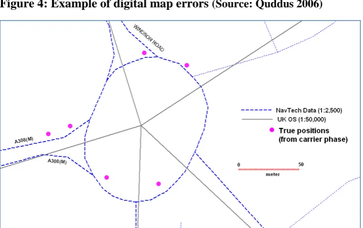
Errors in map creation, projection, geo-referencing and digitisation process create inaccuracies in the digital road map. Moreover, map scale also influences the quality of digital map. The GIS map errors can be broadly categorised into geometric and topological errors (Goodwin and Lau, 1993; Kim et al., 2000). Examples of such map errors include missing road features, displacement and rotation of map features, and representation of road features. An example of mis-representation of a road feature is illustrated in Figure 4. In this scenario, a road feature from two
4 There are now four political regimes providing the global navigation satellite system: the USA’s GPS, the Russian
10
different sources (different scales) are superimposed. In reality it is a roundabout (shown by the dotted line), but due to inaccuracy in the digitisation process, digital mapping convention of representing roads by their central line and also the higher map scale renders the roundabout as a five-legged junction. GPS positioning points obtained from a carrier-phase GPS are shown as bold circles in the figure. If these GPS points are assigned to the five-legged junction, this could cause significant horizontal errors in land vehicle positioning and navigation. Moreover, the GIS road map for the proposed dynamic RUC should also include accurate information on road classification, because one of the variables in calculating user charges is road type.
[Figure 4 near here]
The only evaluation of suitability of existing GIS for satellite-based RUC is by Cheng et al. (2006). They evaluate the suitability of existing digital road maps, in different operational environments in USA, for national level GPS-based RUC applications and conclude that the existing digital maps (which are publicly available) are not accurate enough for GPS-based RUC. However, they recommend that with high accuracy digital maps (not existing at national level) that are used for experimental vehicle safety applications, positioning data from differential GPS, along with sophisticated algorithms and techniques to integrate GPS and GIS data, could make the design and deployment of GPS-based RUC system with high geographical resolution a reality.
5.2.3 Map-matching algorithms to integrate positioning data with GIS map
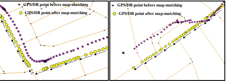
Map-matching algorithms (MMA) are often used to integrate positioning data obtained from GPS or other sensors (e.g., Dead-Reckoning (DR) sensors) with a digital road map representing the road central line (Quddus et al., 2007). The primary aim of a MMA is to identify the road segment on which a vehicle is travelling based on the current location of the raw GPS/DR data point. In recent years, as the requirement for a precise vehicle location has become an important factor in successful development of ITS and various MMA have been developed for specific ITS applications. A comprehensive summary of the latest MMA is contained in Table 2 of Velaga et al. (2012c). A variety of techniques are used in map-matching processes (such as artificial intelligence and probabilistic techniques). The frequency of GPS positioning data, accuracy requirements, the type of map-matching process/technique, algorithm complexity, computational features and calculation speed requirements all vary with each ITS application and purpose.
11
vehicle ‘jumps’ from one road to another road segment that is not directly connected to the first. In both cases the MMA successfully identifies the correct road link.
[Figure 5 near here]
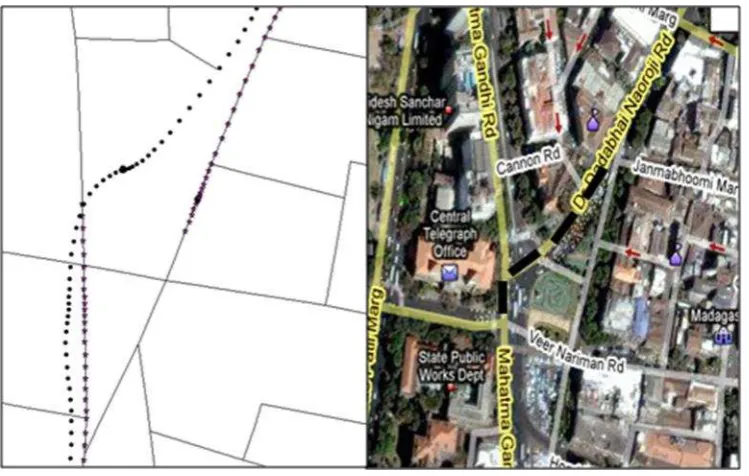
However, in complex operational environments and on dense road networks in urban areas, MMA still sometimes fail to identify the correct road segment on which a vehicle is travelling from the candidate road segments. This phenomenon is known as mismatching. An example of a mismatching error is illustrated in Figure 6. In this scenario, the positioning data from GPS/DR does not look erroneous; however, the final map-matching result shows that vehicle jumps from one road segment to other road. In this case the underlying error is in the map digitisation process. Checking against the corresponding satellite image shown on the right of Figure 7 reveals that a street has been omitted from the digitised map - the path actually travelled by the vehicle is highlighted with a bold dotted line on the satellite image.
[Figure 6 near here]
Toledo et al. (2010a) analysed positioning systems, GIS and map-matching issues for GNSS-based RUC; they found that improvements to MMA are required as the threshold values and other parameters used in a MMA for road segment identification need to be fine-tuned to optimally reduce under- and over-charging.
5.2.4 Impact of inaccuracy on system reliability
Due to GNSS signal errors (e.g., multipath errors in urban areas), errors with GIS road map, and map-matching process errors, vehicles might sometimes be assigned to the wrong road segment (Velaga et al., 2012d). This is a particular problem in dense urban areas with complex and congested road networks (Quddus et al., 2007; Toledo et al., 2010b). False road segment identification in the proposed dynamic RUC could lead to erroneous charges to users. For example, the GNSS-based variable RUC scheme may charge users erroneously in situations where two adjacent roads are priced differently (i.e., charge for a motorway is £2.00 per mile and charge for a minor road parallel to the motorway is £0.50 per mile or even zero). The correct RUC calculation is also dependent on other technology and equipment (e.g., in-vehicle emission monitoring equipment), algorithms (e.g., MMA which integrates GIS and GPS data to identify a road segment on which a vehicle is travelling), and communication architecture. Moreover, when the RUC system is not reliable and there is margin for error, this needs to be transparent to both the system operator and affected road users and business systems put in place to settle disputes.
12
systems and equipment. Missed recognitions represent financial loss to RUC agencies, but it is the false recognitions that affect public acceptability and may lead to legal consequences.
5.3 Hard and Soft Implementation issues with GNSS-based dynamic RUC
The main focus of this paper is the importance of accurate location processing for technical feasibility and user acceptance. However, there is a range of implementation issues that need to be considered holistically.
5.3.1 Technology integration (software and hardware)
In the proposed dynamic RUC system, the calculation of user charges is based on eight variables necessary to better reflect the PPP: exact distance travelled on a chargeable road, time of travel, road class, type of geographic area (urban or semi urban), traffic density (congestion level), vehicle class, pollutant emissions (exhaust mass emission and noise) and vehicle occupancy. To achieve this, tight integration of a range of equipment is necessary. In-vehicle equipment includes vehicle positioning systems (e.g., GPS), a vehicle emissions monitoring unit, a microphone to measure noise, air bag sensors to measure vehicle occupancy. A wireless communication system is also required for communication between vehicles/drivers and charging agencies to supply traffic conditions data to charging and traffic management agencies, warn drivers if cost is rising due to congestion on route (though see 5.3.3 below) and finally to supply the information required on distance travelled for subsequent invoicing of road users. External to the vehicle the system needs to integrate information such as real time traffic density (congestion level) to calculate the user charges. The integration of different equipment to the OBU and its combination with external real-time information (e.g., road segment level traffic density) obtained from other sources is highly challenging but possible with the latest advancement in sensor, computer, communication and information technologies.
5.3.2 Security and trust issues
In addition to the system's reliability, system security is also an important issue from the point of view of both users and operators. System security is an important element for operators in preventing fraud but also for user privacy, which is a key element of achieving public acceptability for the proposed system. ROSPA 2013 finds that the privacy issue for in-vehicle monitoring systems is hampering widespread public acceptance. Data ownership questions, information storage, data processing and transaction processing would all pose stiff challenges.
5.3.3 Safety issues and user friendliness
13
about total journey cost may also lead to social inequity. At this stage we would suggest that 100% dynamism in pricing is not feasible, but that introducing more variables that affect total price to better reflect the true cost of journeys is feasible and desirable.
5.33 Cost of transition
To introduce or deploy the proposed dynamic RUC, based on integrating different equipment and sensors to on-board unit, would have cost implications. Every registered vehicle would need to be equipped with OBUs, either by manufacturers or for older vehicles, retrofitted. There are precedents for building in the required telematics: emerging intelligent vehicles and built-in Sat-Nav systems, the standardization of data in the USA, where Event Data Recorders are being fitted to most new vehicles, and the E-Call system to locate cars in the event of an accident will have to be fitted to all new vehicles from September 2015 (ROSPA 2015).
However, in order to deploy this system for all or most roads at national or regional level (a metro city), there would be practical difficulties over such a large scale. Governance is also an issue in relation to the need to replace or integrate existing smaller scale RUCs (e.g., ETC and ANPR), many of which are wholly or partially in the private sector.
5.3.4 Equity and public acceptability
Experience in a number of places where urban road pricing has been considered suggests that public acceptability hinges on perceived fairness. Firstly, a national RUC ought to replace annual VED and most of the tax burden on fuel (see also 5.3.3 above), as well as assimilate existing schemes. However, in the UK, fuel duty and VED are part of the general taxation system, controlled by the Treasury at national government level, not by the Ministry of Transport, creating a governance issue. Secondly, our proposed GNSS-based dynamic RUC is fair, in that it is based on the PPP. This is a well-established principle in relation to environmental externalities and can be extended by analogy to social externalities. Thirdly,as it is envisaged as national scheme, it is geographically fair within the national boundaries, and pricing can be variable to reflect the different ‘costs’ of urban/rural or peak/off-peak traffic conditions.
Nevertheless, the system proposed here also does not consider ability to pay and other social equity considerations, unless it is programmed to do so. The introduction of direct RUC could be socially regressive if it prices lower-income individuals off the roads in higher cost areas and they have no viable alternative transport. It is known that those on lower incomes are more dependent on second-hand cars which tend to be less fuel efficient, for example (Lucas and Pangbourne, 2012). Therefore a large-scale RUC system could exacerbate some social problems, particularly as a completely dynamic pricing system would be capable of increasing costs in real-time as congestion levels rose means that predictability of journey cost may be harder to gauge, leading to those on lower incomes avoiding journeys altogether if they cannot be sure of the total cost in advance (though see 5.3.3 above).
14
of transport, which could support modal shift, and the dynamic nature of the charge and the feedback that becomes possible with in-car telematics (ROSPA, 2013) could be used to apply behavioural nudges away from the most costly behaviours or even reward desirable behaviours (Tillema et al 2013). The programmability and comprehensive set of measured variables of the proposed GNSS-based RUC system would enable policy design to account for social equity.
6. Summary, conclusions and areas for future research
In this paper we have critically reviewed typical types of RUC using selected examples. We have also discussed some UK cases where the introduction of RUC had to be abandoned due to acceptability problems, contrasting with successful introductions in other countries. We then outline the architecture of a GNSS-based dynamic RUC system capable of addressing some of the drawbacks of less advanced systems. We discuss some of the technical locational issues with GNSS-based dynamic RUC, such as satellite positioning and errors, accuracy issues with GIS road maps and MMA which are typically used to improve precision in vehicle positioning by integrating satellite position and GIS road maps. Then we highlight some of the other implementation issues with the proposed system, including technology integration, security, transition costs, equity and public acceptability.
We suggest that future research is required in the following areas:
(1) Appraisal: introducing the proposed system at national or regional levels is a major undertaking: a full cost-benefit analysis and social impact appraisal of the proposed system in comparison to alternative options is required. Existing feasibility studies of RUC are not based on the type of dynamic RUC that we are proposing.
(2) Technology trials: GNSS-based RUC requires more sophisticated map-matching than existing ITS, and further critical trials are required to test system readiness. The integration of the required in-vehicle sensors with external technologies and processes needs development and trials to ensure system reliability.
(3) User acceptance: both ex-ante and ex-post user acceptance studies are needed through surveys and focus groups, as well as large-scale user trials, in order to assess individual and business user experiences with the proposed system.
(4) Equity: more understanding is needed about how different social groups (including businesses) would be affected by different pricing scheme designs.
15
schemes in the UK, for example, public support amongst Edinburgh residents fell substantially over several rounds of consultation which were extensively covered in media editorials.
Overall we identify potential benefits of such a system that have not yet seen much recognition. For example, the data richness of the proposed GNSS-based RUC system offers the promise of some highly progressive solutions to the social equity issues, as well as providing transport authorities and academic researchers with much more detailed granular data about the travel behaviour of car users (whilst safeguarding privacy), which could lead to much greater understanding of transport needs and wants, better modelling of current and future requirements and better targeting of future investment in transport infrastructure and better tools for facilitating behaviour change.
References
Ardekani, S. A., 1991. Economic Evaluation of Toll Plaza Operations. In proceedings of the 70th Annual Meeting of the Transportation Research Board, Washington, D.C., January 13-17, 1991, pp. 1-35.
Borjesson, M., Eliasson, J., Hugosson, M. B., and Brundell-Freij, K., 2012. The Stockholm congestion charge – 5 years on. Effects, acceptability and lessons learnt. Transport Policy, 20, pp. 1-12.
Broaddus, A. and Gertz. C., 2008. Tolling Heavy Goods Vehicles: Overview of European Practice and Lessons from German Experience. Transportation Research Record, 2066: pp. 106-113. Cheng, P. M., Donath, M., Ma, X., Shekhar, S. and Buckeye, K., 2006. Evaluation of digital maps
for road user charging applications, in Proceedings of the 85th Transportation Research Board Annual Meeting.
Commission of the European Communities (CEC), 1995. Green Paper: Towards Fair and Efficient Pricing in Transport . COM(95)691, December 1995. Brussels
Cottingham D. N., Beresford A. R., and Harle R. K., 2007. A Survey of Technologies for the Implementation of National-Scale Road User Charging, Transport Reviews, Vol 27 (4), pp. 499-523.
Deeter, D., 2009. Real-Time Traveler Information Systems. NCHRP report 399, Transport Research Board, USA.
Duncan, D., and Graham, J., 2013. Road User Fees Instead of Fuel Taxes: The Quest for Political Acceptability. Public Administration Review, 73, 415-426.
DVLA/DfT, 2012. Vehicle Licensing Statistics Table VEH0256. URL:
http://www.dft.gov.uk/statistics/series/vehicle-licensing (accessed 25th September 2012). Feng, S., and Ochieng, W. Y., 2007. Integrity of navigation system for road transport. In
Proceedings of 14th ITS World Congress, Beijing, China, 9–13.
GINA (GNSS for INnovative road Applications), 2010. How Can EGNOS and Galileo Contribute to Innovative Road Pricing Policy? First Findings and Proposals from GINA Project. Brussels, 1 October 2010 <http://www.gina- project.eu/media/workshop/GINA_ Workshop_Summary.final.pdf> (Accessed on 21-11-10).
Glaister, S., 2007. In Seldon, A. (Ed.), Transport in Blair’s Britain 1997–2007. Cambridge: Cambridge University Press.
Glaister, S., 2010. Governing and Paying for England’s Roads. RAC foundation. Available at: http://www.racfoundation.org/assets/rac_foundation/content/downloadables/governing
16
Goh, M., 2002. Congestion management and electronic road pricing in Singapore. Journal of Transport Geography, Vol 10, pp. 29–38.
Goodwin, C. and Lau, J., 1993. Vehicle Navigation and Map Quality, Proc., of the IEEE-IEE Vehicle Navigation & Information Systems Conference, Ottawa, pp. 17-20.
Grush, B., and Roth, G., 2008. Paying for roads in the 21st century with TDP pricing. In proceedings of the 88th Annual Meeting of the Transportation Research Board, Washington, DC. (Paper No. 09-0222).
Grush, B., Cosmen-Schortmann, J., Hamilton, C. and Martinez- Olage, M., 2009. GMAR Standard Performance Definitions for GNSS Road Use Metering. In Proceeding of the 16th World Congress on Intelligent Transport Systems.
Hau, T. D., 1990. Electronic Road Pricing: Developments in Hong Kong 1983-89. Journal of Transport Economics and Policy, Vol. 24 (2), pp. 203-214.
Hau, T. D., 1992. Congestion Charging Mechanisms for Roads: An Evaluation of Current Practice, Infrastructure and Urban Development Department. World bank Report.
Hensher, D. A., and Puckett, S. M., 2005. Road user charging: The global relevance of recent developments in the United Kingdom. Transport Policy, Vol 12, pp. 377–383.
IHT (the Institution of Highways and Transportation), 1997. Transport in the Urban Environment. IHT, London, UK.
Ison, S., and Rye T., 2005. Implementing road user charging: the lessons learnt from Hong Kong, Cambridge and Central London. Transport Reviews, Vol 25 (4), pp. 451– 465.
Johnson, P., Leicester, A., and Stoye, G., 2012. Fuel for Thought: the what, why and how of motoring taxation. Report by the Institute of Fiscal Studies for the RAC Foundation, London. Khan, S., 2005. Variable Pricing Indicators and the Enabling Technology for Comprehensive
Road Pricing. MSc dissertation, University of London, UK.
Kim, W. Jee, G. and Lee, J., 2000. Efficient use of digital road map in various positioning for ITS, IEEE Symposium on Position Location and Navigation, San Diego, CA, pp. 170–176. Kocak, N. A., Jones, P. and Whibley, D., 2005. Tools for road user charging (RUC) scheme
option generation. Transport Policy, Vol. 12, pp. 391-405.
Komada, K.,and Nagatani, T., 2010. Traffic flow through multi-lane tollbooths on a toll highway. Physica A: Statistical Mechanics and its Applications, Vol 389 (11), pp. 2268-2279.
Lucas, K. and Pangbourne, K., 2012. Transport and Climate Change Policy in the UK: A social justice perspective. Chapter 11 in Transport and Sustainability; Vol 2; Edited by Ryley, T. and Chapman; Emerald. ISBN: 978-1-78052-440-5 (in press)
Maruyama, T., and Sumalee, A., 2007. Efficiency and equity comparison of cordon- and area-based road pricing schemes using a trip-chain equilibrium model. Transportation Research Part A, Vol 41 (7), pp. 655–671.
May, A. D., 1992. Road pricing: an international perspective. Transportation, Vol. 19 (4), pp. 313–333.
May, A. D., and Milne, D.S., 2000. Effects of alternative road pricing systems on network performance. Transportation Research 34A (6), 407-435.
Ochieng, W.Y., Quddus, M.A., North, R.J., and Noland R. B., 2010. Technologies to Measure Indicators for Variable Road User Charging. Proceedings of the ICE - Transport, 163 (2) pp. 63-72.
Olszewski, P., and Xie, L., 2005. Modelling the effects of road pricing on traffic in Singapore. Transportation Research Part A, Vol 39 (7–9), pp. 755–772.
17
Quddus, M.A., (2006), High integrity map matching algorithms for advanced transport telematics applications. PhD Thesis, Centre for Transport Studies, Imperial College London, UK.
Quddus, M. A., Ochieng, W. Y., and Noland, R. B., 2007. Current Map Matching Algorithm for Transport Applications: State-of-the Art and Future Research Direction. Transportation Research Part-C: Emerging Technologies, Vol. 15, pp. 312 -328.
Rafael, T. M., Jose, S., Miguel, Z. A. I., Benito, U., and Antonio, G. S. F., 2010. An Analysis of Navigation and Communication Aspects for GNSS-Based Electronic Fee Collection. Proceedings of 17th ITS World Congress, Busan.
Richardson, H., and Bae, C.H.C., 2008. Road Congestion Pricing in Europe: Implications for the United States. Edward Elgar, Cheltenham, UK; Northampton, MA.
Royal Society for the Prevention of Accidents, The (2013). Road Safety and In-vehicle Monitoring (Black box) Technology. RoSPA Policy Paper, February 2013, UK.
Rye, T., Gaunt, M., and Ison, S., 2008. Edinburgh's Congestion Charging Plans: An Analysis of Reasons for Non-Implementation Transportation Planning and Technology, Vol 31 (6), pp. 641-661.
Ryley, T. J., 2010. Travel Behaviour Response to UK Road User Charging. Proceedings of the Institution of Civil Engineers: Transport, 163, Issue TR2, pp. 57-62.
Salos, D., Macabiau, C., Martineau, A., Bonhoure, B. and Kubrak, D., 2010. Analysis of GNSS integrity requirements for road user charging applications. Satellite Navigation Technologies and European Workshop on GNSS Signals and Signal Processing (NAVITEC).
Santos, G., 2005. Urban Congestion Charging: A Comparison between London and Singapore. Transport Reviews, Vol. 25 (5), pp. 511–534.
Santos, G., 2008. London congestion charging. In: Burtless, G., Rothenberg Pack, J. (Eds.), Brookings Wharton Papers on Urban Affairs: The Brookings Institution.
Santos, G., and Fraser, G., 2006. Road pricing: lessons from London. Economic Policy, pp. 265 - 310.
Schade, J. and Schlag, B., 2003. Acceptability of urban transport pricing strategies. Transportation Research Part F, Vol. 6, pp. 45-61.
Shepherd, S. P., Koh, A., and May, A. D., 2008. How to design effective road pricing cordons. Transport, Vol 161, pp.155–165.
Slovak Republic, 2010. Multi-Lane Free-Flow Electronic Tolling in the Slovak Republic. <http://www.asecap.com/english/documents/Multi-Lane_Free-Flow_Electronic_Tolling _in_the_Slo.pdf> (Accessed on: 15-05-2012).
Smeed, R., 1964. Road Pricing: the Economic and Technical Possibilities. (The Smeed Report.)
Ministry of Transport, Her Majesty’s Stationery Office, London.
Sussman, J.M., 2005. Perspectives on Intelligent Transportation Systems. Springer-Verlag Berlin and Heidelberg GmbH (ISBN-10: 0387232575).
Tillema, T., Ben-Ellia, E., Ettema, D., and van Delden, J. (2013). Charging versus rewarding: a comparison of road-pricing and rewarding peak avoidance in the Netherlands. Transport Policy, 26, 4-14.
Toledo, M. R., Ubeda, B., Santa, J., Zamora-Izquierdo, M. A., and Gomez-Skarmeta, A. F., 2010a. An Analysis of Positioning and Map-Matching Issues for GNSS-Based Road User Charging. 13th International IEEE Annual Conference on Intelligent Transportation Systems, Madeira Island, Portugal, September 19-22.
18
Transport for London, 2006. Distance Based Charging: Report on Transport for London’s (TfL) GPS OBU Trial. TfL Congestion Charging (Traffic & Technology). Available at: http://www.tfl.gov.uk/assets/downloads/GPS-OBU-trials.pdf (Accessed on: 15-05-2012).
Ubeda, B., Santa, J. Zamora-Izquierdo, M. A. and Ǵmez-Skarmeta, A. F., 2010 . An analysis of positioning and map-matching issues for GNSS-based road user charging. 13th International IEEE Conference on Intelligent Transportation Systems (ITSC).
Velaga, N. R. and Sathiaseelan, A., 2011. The Role of Location Based Technologies in Intelligent Transportation Systems. Asian Journal of Information Technology, Vol. 10 (6), pp. 227-233. Velaga, N. R., Beecroft. M., Nelson, J. D., Corsar, D. and Edwards, P., 2012a. Transport poverty
meets the digital divide: accessibility and connectivity in rural communities. Journal of Transport Geography, Vol 21, pp. 102-112.
Velaga, N. R., Quddus, M. A., Bristow, A. L., and Zheng, Y., 2012b. Map-Aided Integrity Monitoring of a Land Vehicle Navigation System. IEEE Transactions on Intelligent Transportation Systems, Vol 13 (2), 2012, pp. 848-858.
Velaga, N. R., Nelson, J. D., Sripada, S., Edwards, P., Corsar, D., Sharma, N. and Beecroft, M., (2012c). Development of a Map-matching Algorithm for Rural Passenger Information Systems via Mobile Phones and Crowd-Sourcing. Journal of Computing in civil Engineering, ASCE, (Status: in press). doi: 10.1061/(ASCE)CP.1943-5487.0000238.
Velaga, N. R., Quddus, M. A. and Bristow, A. L., 2012d. Improving the Performance of a Topological Map-Matching Algorithm through Error Detection and Correction. Journal of Intelligent Transportation Systems: Technology, Planning, and Operations, Vol 16 (3), pp. 147-158.
World Commission on Environment and Development (1987). Our Common Future. Oxford University Press, Oxford.
Zabic, M., 2009. Road Charging in Copenhagen: A Comparative Study of the GPS Performance. 16th World Congress on Intelligent Transport Systems, Stockholm, Sweden, October 2009. Zabic, M., 2011. GNSS-based Road Charging Systems Assessment of Vehicle Location
19
Figure 1: Electronic toll collection system
Video
Loop Detectors R F Tag
20
Figure 2: Example of cordon pricing and zone pricing
21
Figure 3. GNSS-based fully dynamic RUC system
GPRS
Base Station
BTS - Base Transceiver Station GPRS - General Packet Radio Service VRUC – Variable Road User Charging ATMS – Area Traffic Management System
User with on- board unit (GPS and DR and GIS map), vehicle emission monitoring unit and sensor based vehicle occupancy monitoring unit.
BTS User updated with VRUC
GIS map
Map-matching
GPS positioning data from user
Other information •Vehicle emission •Vehicle class
•User charging structure
User charge calculation
Road in chargeable zone
Yes
No
No charge
User charge deduction from user account Traffic information,
(congestion levels on each road segment)
22
23
Figure 5: Map-matching algorithms (developed based on the algorithm from Velaga et al., (2012d))
GPS/DR point after map-matching GPS/DR point before map-matching
GPS/DR point after map-matching GPS/DR point before map-matching
24
25
Table 1: Summary of the development of RUC approaches
DSRC: Dedicated Short Range Communication; GSM: Global System for Mobile Communication; ATMS: Area Traffic Management System
Typology Point charging Area based toll Distance Based toll
Manual toll collection
Electronic toll collection
Area licensing
method Cordon pricing Zone pricing
Distance based toll collection
Key criteria e.g. National
Highway 5, India
e.g. M6 Toll Road, UK
e.g. Singapore
(1975 - 1990s) e.g. Oslo city, Norway
e.g. London congestion charge, UK
e.g. HGV RUC, Germany Vehicle Identification Method Visual identification or self check declaration
Electronic tags Manual checks Mainly DSRC ANPR GPS and GSM
Vehicle entitlement Not required Required: vehicle
RFID
Required: spot
checks Required: vehicle RFID Required: through ANPR Required: OBUs
Charge Parameters Vehicle class Vehicle class, time
of trip Vehicle class Vehicle class
Motor vehicles, week days
between 07:00 and18:00
HGV (> 12 Tonne), on motorways only
Payment options
Prepayment: monthly pass or
spot payment
Direct deduction
from users' accounts Prepayment only Prepayment; Post payment
Multiple options: Direct deduction from users’ accounts;
Prepayment; Post payment (up to midnight following day)
Spot payment or deduction from users’
accounts
Critique Queuing delay More road side
infrastructure and space needed
Labour
intensive
Fraud and
corruption
Enforcement
difficult
High capital cost
Duplication: ETC
is combined with lower tech options, requiring toll plazas and labour costs
Fixed charges
only based on vehicle class and broad time-bands
Labour intensive
Enforcement cost
is high
Fixed charges
only based on vehicle class
Users have to
plan ahead
High number of tollgates
is required.
Vehicles inside the
boundaries are not charged
Bad weather conditions
increase ANPR system errors
Fixed charges based only on
vehicle class
Current system is not
integrated with other ITS systems like ATMS.
Variable charging
based only on vehicle class and distance travelled