This is a repository copy of Using workplace population statistics to understand retail store
performance.
White Rose Research Online URL for this paper:
http://eprints.whiterose.ac.uk/98955/
Version: Accepted Version
Article:
Berry, T, Newing, A orcid.org/0000-0002-3222-6640, Davies, D et al. (1 more author)
(2016) Using workplace population statistics to understand retail store performance. The
International Review of Retail, Distribution and Consumer Research, 26 (4). pp. 375-395.
ISSN 0959-3969
https://doi.org/10.1080/09593969.2016.1170066
© 2016, Informa UK Limited, trading as Taylor & Francis Group. This is an Accepted
Manuscript of an article published by Taylor & Francis in International Review of Retail,
Distribution and Consumer Research on 26/04/2016, available online:
http://www.tandfonline.com/10.1080/09593969.2016.1170066. Uploaded in accordance
with the publisher's self-archiving policy.
[email protected] https://eprints.whiterose.ac.uk/ Reuse
Unless indicated otherwise, fulltext items are protected by copyright with all rights reserved. The copyright exception in section 29 of the Copyright, Designs and Patents Act 1988 allows the making of a single copy solely for the purpose of non-commercial research or private study within the limits of fair dealing. The publisher or other rights-holder may allow further reproduction and re-use of this version - refer to the White Rose Research Online record for this item. Where records identify the publisher as the copyright holder, users can verify any specific terms of use on the publisher’s website.
Takedown
If you consider content in White Rose Research Online to be in breach of UK law, please notify us by
Using workplace population statistics to understand retail store performance
Tom Berry1, Andy Newing 1, 2*, Deborah Davies3 and Kirsty Branch3
1 Consumer Data Research Centre, University of Leeds, Leeds, LS2 9JT, UK
2 School of Geography, University of Leeds, Leeds, LS2 9JT, UK
3 The Co-operative Group, 1 Angel Square, Manchester, M60 0AG
* Corresponding author, Email: [email protected], Tel: 0113 343 6720
Abstract
We explore the value of recently released workplace geographies and accompanying census-based workplace zone statistics (WZS) and an associated classification of workplace zones (COWZ). We consider how these data could support retailers in their operational and strategic decision making, including the evaluation of retail demand and retail store performance in localities where trade is
driven by non- I UK The Co-operative
Group
characteristics using a series of case study stores within Inner London. We use empirical store trading data to identify store and product category level temporal sales fluctuations attributable to workplace populations. We also use census-derived flow data to identify the spatial origins of workplace population inflow. We identify that store performance exhibits characteristics attributable to demand driven by these populations. We conclude that workplace population geographies, WZS and the COWZ afford considerable potential for understanding drivers of store performance, observed store trading patterns and evaluation of retail store performance. We suggest that the next step is to build these populations and their micro geography spatial and temporal characteristics into predictive models and evaluate their potential for store performance evaluation and location-based store and network decision making within this sector.
Key words
W W C C -Operative
F I L
Workplaces as a driver of retail demand
Workplaces are a key driver of non-residential daytime population distributions and associated origin-destination flows driven by the journey to work (Martin, Cockings, and Leung 2015; Martin, Cockings, and Harfoot 2013; Smith and Fairburn 2008). The presence of workplace populations within city centres, out of town office developments or an industrial centre, for example, may represent important drivers of demand for local services, including the retail sector. Retail demand originating from these populations may not be adequately captured by traditional census-based population statistics which are primarily based on residential geographies (Martin, Cockings, and Harfoot 2013). We assess whether recently published output geographies and population statistics related to workplace populations can support the evaluation of retail demand and retail store performance in localities which experience an inflow of workplace populations.
We make use of census-based Workplace Zones (WPZsi) and associated Workplace Zone Statistics (WZSii) published by the Office for National Statistics (ONSiii) (Mitchell 2014; ONS 2014a). We also introduce a geodemographic classification of workplace zones (COWZiv), derived from the 2011 census in England and Wales and published by the University of Southampton in conjunction with the ONS (Cockings, Martin, and Harfoot 2015a). These data provide considerable enhancements to the provision of small area population statistics related to workplace populations, enabling analysis of their composition, characteristics and flows using a set of geographic zones specifically designed for the dissemination of workplace population statistics. This paper is focused explicitly on the UK (and specifically England and Wales) given the availability of these data. Nevertheless, the international importance of and interest in data on workplace populations and their spatial and temporal distributions has been recognised (Martin, Cockings, and Harfoot 2013; Bell 2015).
This study has been undertaken in conjunction with the Co- G The Co-operative Food C -op). Co- UK
retailer (by market share), with a national market share of around 6.5%1 across the grocery sector. Co-op derives market share from a network of ~2,800 stores which include smaller-format local or
convenience stores (stores under 3,000 ft2 shopping in urban
and suburban neighbourhoods, rural areas, transport interchanges, town and city centres, petrol station forecourts etc.) and medium-sized supermarkets meeting the everyday shopping needs of
local communities. The Co-
development and portfolio review (including refits, changes to product ranges, opening hours etc.,)
-shopping close to home, work, place of study, transport networks or other amenities (Elms et al. 2010; Thompson et al. 2012; Hood, Clarke, and Clarke 2015).
Drivers of small-format food store performance are complex and reflect the spatiotemporal characteristics of demand in the vicinity of a given store. Stores predominantly serving a suburban
neighbour
different trade pattern to stores serving major town or city centre locations (ACS 2015). In these urban centres store level trade is predominantly non-residential and driven by the presence of local workers,
shoppers, students, tourists and people in transit. Identifying the composition, characteristics and spatiotemporal behaviours of these non-residential populations - within tightly defined store catchment areas is crucial for understanding the demand-side drivers of trade in these localities (see Hood, Clarke, and Clarke 2015, for a more detailed disussion of key variables influencing consumers' shopping missions in convenience stores).
The store-level drivers and impacts of non-residential demand - and workplace demand in particular - remains an under-researched area. Thus, operational decision making (store ranging and product placement, staffing and localised offers) may be based on an incomplete evidence base, with a lack of robust data on workplace populations. Similarly, strategic decision making including store performance evaluation (assessing observed store trading performance relative to indicators of likely store performance) and store location planning (identifying locations for new stores and predicting their trading potential) requires detailed demand-side insight (Birkin, Clarke, and Clarke 2016). Prior to the release of specific workplace geographies, workplace population statistics and area-based classifications, there have been limited demand-side data related to non-residential populations suitable for retail decision making.
We make use of empirical store trading data and performance indicators provided by the Co-op, with the explicit aims of a) evaluating the utility of WPZs, census-derived WZS and the COWZ as tools to support retail operations and location-based decision making, and; b) improving retailers understanding of the drivers behind observed small-format food store trading characteristics in areas with considerable workplace populations. We specifically consider Co-op stores in Inner London where store trading characteristics are predominantly attributable to demand originating from workers and commuter flows, rather than originating from local residential populations.
Whilst this journal has previously reported on empirical research to understand the localised impact of non-residential demand in the grocery retail sector (Newing, Clarke, and Clarke 2013), we believe this to be the first such study explicitly addressing workplace populations. The recent release of WZS using custom-built output geographies provides new opportunities to understand the micro geographies of workplace demand as a potential driver of individual retail store performance. We believe, therefore, that this study is both timely and relevant. We hope that this paper will support the retail sector in evaluating the utility of census-based workplace geographies and population statistics. There are an absence of academic studies that demonstrate the impact of workplace populations on retail store trading characteristics, and the empirical analysis presented in this paper will go some way to address that gap in the literature.
In the following section we briefly outline the development of workplace geographies, WZS and the COWZ. We explore the characteristics of Inner London workplace populations using these data, linking these populations to observed trading characteristics at selected Co-op stores. We subsequently reflect on the value of these data for supporting retail operations, for the evaluation of store performance and for location-based decision making by retailers trading within highly transient workplace locations.
Census-derived workplace population geographies and population statistics
residential populations are the primary tool for small-area expenditure estimation, store-location planning and store performance assessment (Birkin, Clarke, and Clarke 2016; Newing, Clarke, and Clarke 2013). Census-based population statistics used for retail analysis in the UK are reported in
T
output zones related to residential geographies, of which Output Areas (OAsv) are the smallest. OAs are built from unit postcodes with the explicit aims of generating a set of output zones with consistent population and household counts (with a target size of 125 households), geographical compactness and social homogeneity (Coady 2014; Martin, Cockings, and Harfoot 2013). OAs are an important geographic zone for retail analysis and are widely used for demand estimation, market share evaluation and area-based geodemographics. However they are not best-suited to the release of data related to populations which have a spatial distribution that is not consistent with residential populations. Many residential areas contain very limited workplace populations, in many cases failing to meet minimum statistical disclosure control thresholds required to enable the release of workplace statistics at this level of aggregation (Mitchell 2014). As such, attempts to release workplace
OA
of the 2001 census, had very limited success in part due to concerns over potential disclosure risks (Martin, Cockings, and Harfoot 2013). Such risks were driven by the spatial mismatch between residential and workplace populations, rendering residential geographies as not fit-for-purpose for the release of workplace population statistics.
Major employment centres such as inner-
factories, industrial estates, hospitals and educational establishments often contain very few residential dwellings and limited residential populations. Thus, OAs containing predominantly commercial, administrative, industrial and educational land uses often cover a large spatial extent in order to meet minimum residential population thresholds for statistical disclosure control (40 households and 100 people) (ONS No Date). Clearly the spatial distributions of workplace and residential populations, and most notably the locations in which the former concentrate, are not consistent. Three quarters of 2011 OAs in England and Wales contain less than 100 workers, yet over 4,000 OAs contained workplace populations in excess of 1,000 workers (Coady 2014). Thus by their very nature as a residential geography, OAs are unsuited to the dissemination of workplace population statistics.
In light of these weaknesses, and following extensive user and public consultation (see ONS 2011b, for a summary) and academic input (see for example Martin, Cockings, and Harfoot 2013), ONS released
W ) (WPZs) in 2013. WPZs were created using data related to respondents place of work and are designed to complement OAs, providing national coverage at the small area level to support the release of data related to workplace populations. They are designed to be as compact as possible, to contain consistent counts of workers and maintain internal homogeneity, where possible, in terms of the industry or sector of employment (Mitchell 2014).
and Harfoot 2013; Mitchell 2014). Statistical disclosure control stipulates a minimum workplace population size (200) and zonal constraints (minimum three separate unit postcodes) such that individual workplaces cannot be identified (Mitchell 2014).
Figure 1 shows the relationship between 2011 OAs and WPZs for two London boroughs, Tower Hamlets and the City of London. The predominantly non-residential City of London (also known as the Square Mile) contains just 31 OAs, driven by the very low residential populations within this financial and business district (Table 1). With a workplace population of over 350,000 individuals, these City of London OAs have a mean workplace population of over 11,000, with one OA containing 127,354 workers. This is a clear example of the need for WPZs, with the City of London OAs having been split to form 349 WPZs (a tenfold increase on the number of OAs), with a mean workplace population of just over 1,000 workers per WPZ. The one OA with 127,345 workers has itself been split to form 115 separate WPZs, considerably increasing the geographical resolution of workplace population distribution within the City of London.
In the more residential London borough of Tower Hamlets, a majority of the 748 OAs have been merged to form just 251 WPZs (Figure 1 and Table 1). Mitchell (2014) notes, however, that two Tower Hamlets OAs contain workplace population counts in excess of 35,000 workers. These OAs, located on
I D
complex change involving a combination of merging and splitting of OAs) to form 15 WPZs to accommodate the Canary Wharf development, the single largest business district in the UK, containing over 15m ft2 of office, retail and leisure space (Canary Wharf Group 2015).
Table 1 Comparison of OA and WPZ residential and workplace population counts and compositions for the City of London and Tower Hamlets.
City of London Tower Hamlets
OAs WPZs OAs WPZs
Count 31 349 748 251
Mean Residential Pop 260 n/a 361 n/a
Max Residential Pop 461 n/a 1,533 n/a
Mean Workplace Pop 11,507 1,022 314 935
Max Workplace Pop 127,354 6,636 35,746 11,403
[image:6.595.78.514.440.720.2]In areas of high workplace population density, WPZs are smaller than the corresponding OAs and provide considerably greater detail in relation to the spatial distribution of the workplace populations within commercial centres such as the City of London and Canary Wharf (Tower Hamlets). From the retail analytics perspective workplace zones enable the provision of meaningful census-based WZS, using a fit-for-purpose output geography.
WZS report counts of workers by WPZ and associated attributes related specifically to the population working within that WPZ, based on the self-reported postcode of their usual place of work. Those attributes include age, sex, ethnic group, general health, qualifications and employment status etc., routinely collected as part of census questions related to usual household residents. For a full list of WZS released see ONS (2014c). The workplace population of a given WPZ includes a) non-resident commuter inflow, b) home workers with a home address in that WPZ and c) usual residents of that WPZ who are in employment but have no fixed place of work. It relates only to those people working within a given area (whether from home or a commercial premises) and should not be confused with
the workday including usual residents who are not in work (see ONS 2014c, for a more detailed overview of workplace and workday population bases and their relationship to usual resident populations).
A Classification of Workplace Zones (COWZ) has also been produced; grouping WPZs based on the geodemographic characteristics of their workplace populations. Existing geodemographic classifications such as the 2011 ONS Output Area Classification (OACvi) (ONS 2014a; Gale 2014) have become important segmentation tools used by the retail sector to support operational, location based and marketing decisions (Birkin, Clarke, and Clarke 2016). The OAC classifies OAs based on the characteristics of usual residents, the composition of their households and the nature of their dwellings (ONS 2014a; Gale 2014). Whilst the OAC incorporates some indicators related to usual resident employment status and characteristics of that employment, it does not account for the characteristics of workplace population inflow. Commercially available geodemographic
CAMEO W
CAMEO ,
makes use of residential geographies (Postal Sectors and OAs) as the output geography (CallCredit 2015). The COWZ account for employee and employment characteristics and is reported at the WPZ level, thus addressing some of the limitations of the OAC or commercial
classifications in this context.
The COWZ has been developed using a comparable approach to the OAC, utilising a hierarchical k-means clustering process (Cockings, Martin, and Harfoot 2015e). It segments and classifies WPZs based on indicators of the composition and socio-economic characteristics of their workplace populations, the nature of their employment, and an indicator of the built environment within each WPZ (Cockings, Martin, and Harfoot 2015e). Resultant clusters were designed in consultation with
(Table 2) (see Cockings,
Martin, and Harfoot 2015b, 2015c, 2015d; 2015e, for more detail on the COWZ methodology, supergroup and group structure and profiles for individual supergroups and groups). Supergroups
identify the nature of typical employ or
our store level case studies) reflects high status employment centres related to commerce, finance, and public service and is comprised of constituent groups such as G B B C L Given the important role of geodemographic segmentations such as the OAC in the estimation of retail demand and the analysis of store performance in the retail sector, the COWZ could afford tremendous potential in this sector. The tendency for workplace populations to cluster spatially and thematically (e.g. education, retail, financial, legal, agricultural etc.) at the small area level has important implications for the estimation of retail demand and the analysis of retail store performance.
Table 2 Overview of COWZ Supergroups (Cockings, Martin, and Harfoot, 2015e).
Supergroup ID Supergroup Name
1 Retail
2 Top Jobs
3 Metro Suburbs
4 Suburban Services
5 Manufacturing and Distribution
6 Rural
7 Servants of Society
WPZs have been designed for the release of workplace population statistics and specifically address the limitations of using residential output geographies for the visualisation and analysis of data related to workplace populations. It is important to recognise, however, that the census is not an enumeration of workplaces or their employees. Therefore WZS and the COWZ are not derived from or linked to other ONS surveys of businesses or their employees such as the Annual Business Survey, Business Register and Employment Survey or Monthly Business Survey. They relate solely to 2011 census respondents self-reported employment status, place of work and characteristics.
This potential of these data, all of which are freely available, has been recognised by the industry. The Society for Location Analysis (SLAvii), which supports the interests of the site location community, held
All you need to know about Workplace Zones
release of WPZ data (SLA 2014). It is hoped that this paper, produced shortly after the release of the COWZ, will provide further impetus for the retail sector to consider the value of free and openly accessible WZS and COWZ. In the following sections we explore WZS and the COWZ for Inner London, specifically considering their role in the analysis and evaluation of retail store performance in areas dominated by workplace populations.
Inner London Workplace Populations
F L I L
statist L B C L 2 (Figure 2). Inner London functions
as a major employment centre with considerable workplace population commuter inflow. WZS reveal that over 2.7m employees are recorded as having workplaces located within Inner London. High density clusters of workplace populations (Figure 2) present considerable opportunities to evaluate
2 For the dissemination of statistical workplace and population data, the City of London can be considered
the impacts of these populations on the retail sector. This section explores the WZS and COWZ for Inner London, identifying and illustrating the insights afforded by this alternative population base.
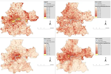
Figure 2 Inner London boroughs and Co-op stores. The Strand, Great Portland Street and Ludgate Circus study stores are identified. Workplace index score shown for all Inner London workplace zones based on workplace population density.
Figure 2 reveals an indicator of the underlying workplace population intensity (WPIviii). This has been derived by categorising WPZs into one of 8 quantiles based on their workplace population density. The WPI enables identification of those WPZs with the highest density of workplace populations. Unsurprisingly, clusters of high density workplace populations are evident in Westminster (home to Parliament), within the City of London (a major financial district) and a distinct cluster in the borough of Tower Hamlets around the Canary Wharf development. The single highest workplace population intensity is found at Plantation Place, which is one of the largest office developments in the City of London financial district.
The COWZ reveals that Inner London is almost exclusively dominated by WPZs where the nature of
T J M “ C
London boroughs of Westminster, City of London and Tower Hamlets. This supergroup includes the
WPZs notable for their high density workplace populations, comprising highly qualified employees with a tendency for longer distance commuting (Cockings, Martin, and Harfoot 2015a).
[image:9.595.71.521.109.411.2]WPZ irrespective of place of residence. It is clear that the central London boroughs of Westminster and the City of London contain a high proportion of high social class professionals, managers or working full time, consistent with the nature of the governmental, financial and legal organisations located in these areas. Similarly, there is a clear spatial pattern to commuting, with a high propensity for employees working in Inner London to commute by train or tube (metro), as discussed further below.
Figure 3 Key indicators of Inner London workplace population composition and characteristics by workplace zone. Source: derived using WZS (ONS 2014b)
B COW) I L WP) T J
almost 1.9m employees, around 69% of the total employees working in Inner London. In the following section we make use of the COWZ at the group level, in conjunction with WZS in order to understand
T J C
-op stores.
Store trading characteristics driven by workplace populations
At the time of analysis the Co-op operates a total of 85 stores in Inner London, with an average size of just over 3,000 ft2. As a relatively late entrant to the convenience retail sector in Central London, Co-op were able to learn from the experiences of their competitors and their own insights into consumer behaviours and preferences. Consequently, store locations, formats and in-store offer (e.g. ranging) have been tailored to the needs of Central London residential, workplace, commuter and leisure consumers. The research underpinning this paper demonstrates Co-
[image:10.595.73.525.171.474.2]understanding of the impacts of workplace populations on their store operations within this
geographical area. Exploratory Co-
their Inner London stores where trade is believed to be driven largely by non-residential workplace
T
consumption. These stores are located in areas where considerable clusters of affluent and professional workplace populations exist (Figures 2 and 3). The assumed drivers of trade within this group of stores corresponds closely to the catchment area characteristics which Hood, Clarke, and Clarke (2015) associate with a distinctive cluster of convenience stores located in major town/city centres or in proximity to transport interchanges.
We focus in particular on three of these stores; Strand, Ludgate Circus and Great Portland Street (Figure 2). These stores are all located in Central London (the commercial heart of Inner London) and have been selected for further analysis due to the intensity of workplace populations in immediate proximity to these stores. On the supply side, the Co-op have particular interest in understanding the drivers of trade at these specific stores, which include established and well-performing stores and more recent store investments. The Strand and Ludgate Circus stores also enable us to consider the presence of proximate major transport interchanges which are likely to drive additional workplace-driven commuter footfall around these stores.
We make use of store trading data for the calendar year 2014, enabling us to identify store transactions and revenues by product group and by time period (morning 7am to midday; afternoon midday to 4pm; early evening 4pm to 7pm and; evening 7pm to store close or midnight). Where stores opened during 2014 their performance indicators are based on 2014 trading characteristics since launch. We also make use of an 8-week snapshot of store sales and transactions by hour of the day, covering an 8 week period during December 2014 and January 2015, but excluding Christmas and New Year. All observed trading patterns reported within this paper reflect store trading characteristics at the time of analysis. Trading patterns may have subsequently changed as a result of store refits and range/category reviews. Some data have been rounded, generalised, aggregated or redacted for publication in order to preserve commercially sensitive information, but were incorporated in their raw or most detailed form within the analysis.
Using Co-op insight and anecdotal evidence of industry practice for convenience stores in major urban areas, we constructed indicative store catchment areas using 500m buffers, broadly equating to a 5 minute walk. Given the nature of these store locations in L
with limited parking, pedestrianisation and traffic congestion, almost all store level trade is driven by consumers accessing stores on foot. The micro geographies of store location in relation to workplaces, transport interchanges and competitor stores are important in driving observed trading patterns. In particular, proximity to - and visibility from key commuter and workplace population footfall routes and transport interchanges are important in driving store level trade, as explored throughout our discussion of trading characteristics at these stores.
The 500m inferred catchment area for our Strand study store contains just three OAs, yet 81 WPZs, demonstrating the increased spatial detail that this geography provides within areas of low residential
and considerable non- T L C L
workplace population of our three study store catchments (Table 3). Table 3 provides detail on the workplace populations falling within each store catchment. Table 3 includes a count of WPZs and
work COW) COW) T J
store catchment areas, with all WPZs falling within the Strand and Ludgate Circus store catchments, and all but two of the 140 WPZs in the Great Portland Street catchment, categorised within this supergroup. The spatial distribution of those COWZ groups within each store catchment clearly reflects the nature of the employment opportunities, with core administrative and commercial sectors evident. Given their proximity to these major clusters of workplace populations, we would expect
trading characteristics at Co- I L
presence of these populations.
Table 3 W WP)
COW) “ C COW)
-EW (Cockings, Martin, and Harfoot 2015a).
Strand Ludgate Circus Great Portland St
COWZ Group WPZs
Workplace
Pop WPZs
Workplace
Pop WPZs
Workplace Pop
Supergroup: Top Jobs
Administrative Centres 13 15,512 4 4,003 23 8,014
Big City Life 32 13,044 7 2,351 35 13,849
Global Business 36 25,527 58 63,503 79 38,356
Science and Business
Parks - - - - 1 232
Supergroup: Metro Suburbs Cosmopolitan Metro
Suburban Mix - - - - 1 235
Supergroup: Retail
Shop until you Drop - - - - 1 219
Total 81 54,083 69 69,857 140 60,905
“
-store transactions at these -stores are dominated by high-volume low-value transactions incorporating product lines such as soft drinks, confectionary, crisps, snacks, breakfast cereals, fruit and veg and dairy provisions (including milk and juices). These product lines and associated high-volume low-value transactions are likely to be attributable to workplace populations purchasing food for immediate consumption (including breakfast and lunch items) during the workday or essential top-up shopping as part of the journey home.
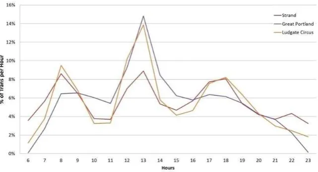
[image:12.595.73.525.282.468.2]Figure 4 - Transactions by hour of the day (expressed as a proportion of total store transactions) for three Inner London case study stores. Averaged across all weekdays during 8 representative weeks in 2014 and 2015.
Across our three study stores variations in these temporal trade profiles are exhibited. Based on a
dependence on lunchtime trade, in driving transaction volumes at the Strand store. Around 40% of all transactions at the Strand store take place in the morning (6am to midday) period, in contrast to just over 20% at both the Great Portland and Ludgate Circus stores. By contrast, over 40% of transactions
G P “
the core lunchtime trade. We now explore some of the differences in store trading profiles with reference to the characteristics of the stores themselves, the composition and likely spatial origins of workplace populations in proximity to these stores and the nature of local competition.
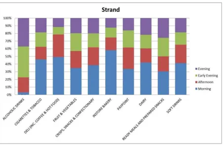
The Strand store derives high volume sales during the morning from the in-store bakery and delicatessen (which includes sales of coffee and hot food), consistent with commuters and workplace populations in the vicinity of the store. It may be driven by the proximity of this store to the major commuter rail terminus at Charing Cross, with morning trade driven by commuters passing through this station, the sixth busiest in the UK with an annual footfall of over 50 million people (Network Rail 2013). Similarly, trade in the early evening (4pm 7pm) includes notable sales of alcohol, ready meals
Figure 5 - Proportion of in-store transactions by time of the day for the Strand store (2014)
By contrast, the Great Portland Street store is not proximate to a major transport interchange. Therefore, daytime workplace-induced trading characteristics are more likely to be influenced by those working in proximity to the store and predominantly driving lunchtime trade, in particular
BBC B H In common with the
Strand store, this store exhibits strong micro locational factors in relation to major competitors. This
BBC B H
area on a major thoroughfare between Oxford Circus and Great Portland Street. The strong performance of specific product lines such as sandwiches and core product categories including soft drinks and crisps, snacks and confectionary, is consistent with lunchtime trade driven by workplace populations. The early evening sales uplift is not so prominent at this store (Figure 4), yet revenues at this time of the day are dominated by sales of alcoholic beverages, consistent with post-work purchases by these workplace populations. Nevertheless, and in spite of its location in proximity to
stales uplift to the same extent as the Strand.
The Ludgate Circus store is located within the City of London financial district, an area of very high density workplace populations (Figure 2). This store has an excellent micro location, on a major
crossroads and immediately C T , a
major footfall driver. T “ P
area of the City. This store exhibits considerable lunchtime trade, yet this trade is dominated by low-value transactions of crisps, snacks, confectionary, soft drinks and fruit and veg. An evening sales peak is also evident (Figure 4) with strong sales of alcohol during the late afternoon and evening periods.
London store revenues on this product line, perhaps suggesting particularly localised demand for
L
At an operational level, maximising revenue from this combination of high-volume low-value lunchtime transactions and low-volume high-value evening transactions may present challenges and opportunities. These, along with further implications and recommendations based on observed trading characteristics, are discussed further below. Firstly, however, we consider flow or interaction data in order to draw observations about the spatial origin of these workplace and commuter populations.
Workplace population inflow to Inner London store catchments
Figure 6 - Workplace population residential origin by Inner London case study store: a) Ludgate Circus b) Strand and c) Great Portand Street. Residential origin is shown at MSOA level and relates to all individuals with a self-reported workplace location in a workplace zone falling within the relevant store catchment area. Derived from 2011 Census Special Workplace Statistics (ONS 2011b)
catchment, and the observed characteristics of these workplace populations (Figure 3) it is unsurprising that clear clusters of inflow originate from core affluent commuter towns such as Sevenoaks, in part driven by rail transport linking commuter towns from across Kent, Sussex and South East London directly with major rail termini in the City of London. By contrast, inflows to WPZs within the Great Portland Street store catchment area are slightly more tightly clustered from origins within Greater London and in a corridor extending north and north west into Hertfordshire and Buckinghamshire, where major commuter towns such as Chesham are served by direct rail links to Great Portland Street Underground station.
The patterns observed in Figure 6 confirm reasonable expectations about the nature of commuter inflow to Central London workplaces. Such analysis affords considerable potential for retailers to understand more about the nature of commuter flows and provides opportunities to target their in store offer appropriately. For example, the typical mode of transport (train) and distance travelled by commuters using the Ludgate Circus and Strand stores may considerably limit the potential for sales of bulky, heavy or perishable goods due to the impracticalities of carrying grocery shopping on commuter transport. They also afford potential for retailers such as the Co-op to understand more about the connections between different parts of their store network, as discussed in the following section, where we comment on the utility and potential of these forms of analysis for the retail sector.
Implications and value for the retail sector
Our analysis of Co-op store trading characteristics highlights the importance of workplace populations in driving observed trading patterns at stores in highly transient locations. The recent availability of freely accessible data related to workplace populations and their composition and characteristics thus affords considerable potential for the retail sector. Anecdotal evidence of industry practice suggests that, to date, the focus on workplace populations within retail organisations has been led by
P L P “ L T
reinforced by the selection of workplace populations as a specific topic for an SLA event (SLA 2014), attended almost exclusively by professionals within this sector. The academic-industry collaboration which formed the basis for this research is also driven by the property function within the Co-op.
Nevertheless, a number of the insights gained from our analysis of workplace populations have the potential to support operational decision making related to store operations and marketing, which are not the preserve of location or property teams. Wood and Reynolds (2012) clearly demonstrate the potential for the analysis and insights originating from these location-based functions to support wider decision making across these organisations. We argue that the potential operational uses of these insights related to workplace populations highlight the need for intra-organisational knowledge-sharing in order that these analysis can support both strategic and operational functions. Drawing on our observations in relation to Co-op stores in Inner London, this section identifies specific enhancements to operational and strategic decision making which could be achieved through incorporation of workplace population statistics.
and late afternoon/early evening (4.30 - T
are likely to be undertaking a very specific shopping mission, based around the purchase of key breakfast and lunch items, plus snacks and drinks in these convenience stores. The temporal concentration of this trade around the lunchtime period is likely to present a number of operational challenges for these stores related to servicing a high volume of low-value transactions, maintaining on-shelf availability of these key product categories and managing in-store congestion.
The nature of these store catchments, which are predominantly non-residential, limit the volume of transactions on heavier, bulkier or perishable top-up shopping, driven by the high propensity for trade to originate on foot, with many consumers having lengthy commutes by public transport, which may not be conductive to transporting any more than essential grocery shopping. There may thus be limited opportunities to directly generate increased basket-sizes or additional revenue from these consumers due to the specific shopping mission and the nature of demand within these catchments. However, the high sales of specific niche lines such as champagne, at the Ludgate Circus store, suggests that careful consideration of store ranges and product lines at the store level is important in order to maximise sales opportunities. The very high proportion (84%) of WPZs in this store catchment
G B is indicative of these types of purchases, with the group dominated
by employees in elite managerial and professional roles (Cockings, Martin, and Harfoot 2015a).
The strong late afternoon and evening transaction volumes of higher-value alcoholic beverages and ready meals at these stores represents a distinct shift from the morning and lunchtime bakery and deli sales. Maximising revenue from this combination of high-volume low-value lunchtime transactions and low-volume high-value evening transactions may present considerable opportunities. Flexible use of sales space and in-store ranging to prioritise bakery and deli lines during the morning and lunchtime period, followed by alcoholic beverages and ready meals in the late-afternoon and evening periods would maximise the fit with typical customer shopping missions.
Furthermore, high volumes of affluent consumers utilising these Central London stores present considerable broader opportunities for retailers such as the Co-op to increase their brand presence, brand loyalty and market shares. The habitual nature of workplace (lunchtime) trade means that consumers may frequently visit the same stores in proximity to their workplace, yet may not routinely use other Co-op stores when shopping from home or elsewhere. Our analysis of interaction data
H
C C -op have fewer stores. Central London Co-op
stores could thus be seen as flagship stores where the Co-op brand and values are showcased to the consumer and where vouchering or other promotions could be used to incentivise consumers to use Co-op stores in proximity to their home neighbourhoods, many of which are likely to stock larger ranges and facilitate a larger basket size and value.
and visible convenience store to a nearby key transport interchange. By contrast, the Great Portland Street store does not contain a major transport interchange within its catchment area, but occupies an optimum location on a major thoroughfare adjacent to a major employment site. Whilst this store exhibits very strong lunchtime performance, driven by proximate workplace populations, the comparatively poorer morning and late afternoon/evening performance is likely to be partially driven by the lack of a proximate transport interchange. We suggest that an area of further research should consider these locational factors in detail, considering micro level pedestrian flows, footfall and their temporal characteristics.
Considerable potential also exists to incorporate workplace population data within store performance evaluation and store location planning functions. Hood, Clarke, and Clarke (2015) note that competition between the major retailers within the convenience grocery sector has intensified the need for robust location-based decision making. Such decision making seeks to evaluate the trading potential of possible new sites and select the best locations for new convenience store development. Given the important role of workplace populations in driving trade at these city centre stores, we argue that the next step is to build these workplace populations into the spatial decision making tools used by retailers for site evaluation.
Wood and Browne (2007) assert that location planning and analysis tools used for large food store
development are 233)
approach. Thus site visits and analogue approaches (predicting sales at proposed store investments by comparison with existing stores which are similar in size, location and catchment) remain important tools for convenience store location-based decision making (Birkin, Clarke, and Clarke 2016; Wood and Browne 2007) . Within densely populated urban areas such analogies would commonly include footfall, visibility, local competition and adjacencies (complementary and competing services within the immediate store vicinity). The incorporation of workplace population statistics and the COWZ offers tremendous potential to select analogues which are comparable to a target site in terms of the magnitude, characteristics and spatial origin of proximate workplace populations.
For large format store development retailers use sophisticated gravity or spatial interaction models (SIMs) and associated spatial decision support systems (SDSS) to predict interactions between retail demand and supply (accounting for store accessibility and attractiveness), enabling prediction of store revenues, retailer market shares and impacts of new store openings on competitors (Birkin, Clarke, and Clarke 2016; Wood and Browne 2007). Whilst we are unaware of current SIM applications for convenience store location-based decision making, ongoing research outlined by Hood, Clarke, and Clarke (2015) recognises the need to evaluate the potential contribution that spatial modelling, including the SIM, could make within the convenience foodstore sector. We argue that the availability of small area data related to workplace populations could considerably improve the feasibility of this approach.
forecasting tools, such as the SIM, to support site evaluation for these smaller-format stores. The greater demand-side locational precision provided by WPZs could make this form of modelling viable at this spatial scale.
A modelling framework incorporating workplace populations would be suitable for the assessment of potential new store locations, providing robust estimations of the volume and composition of non-residential trade to support an evaluation of trading potential. They could also support the identification of existing stores that are performing above/below their modelled potential, enabling retailers to look more closely at the specific trading characteristics of individual stores, in conjunction with demand and supply side data (for example related to competition) and micro level location factors (such as the presence of transport interchanges), in order to understand more about the specific drivers of performance at a store level. In turn, such an assessment would enable pre- and post-investment review to consider not only overall store performance, but also suitability of store format, marketing, ranging and operational characteristics.
Spatial modelling incorporating workplace populations may also support retailers with the
development of new store formats within high- “
2 store in Central London (Felsted 2015), plus the opening of dedicated
F M M “
populations via the development of new formats suitable for major city centre locations. Retailers across a range of sectors are recognising a propensity for store-level demand to be driven by non-residential workplace and transient populations, such as workplace populations shopping close to
work A C C
operated by traditional high street retailers such as Argos, or specialist e-commerce collection point operator Doddle have emerged at major commuter transport interchanges and high footfall
workplace locations in London. T on
that workplace populations represent an important component of store-level demand, fuelled by the availability of robust workplace population statistics, discussed further in our concluding section.
Workplace populations for retail analytics
Our analysis, based on selected Co-op convenience stores in Inner London, strongly suggests that observed store-trading characteristics at these stores are driven by considerable workplace populations within these store catchments. In the commercial and administrative heart of Central London, traditional census-based residential population statistics fail to capture these drivers of retail demand. Non-residential populations, and in particular workplace populations and commuter inflow, represent a crucial alternative population base which we argue is essential for robust retail analytics in locations where considerable clusters of workplace populations are found. These locations include major city centres, such as in our case studies, but also extend to large hospitals, educational establishments (e.g. universities), retail centres and major science or industrial parks.
area workplace population statistics which could support retail analysis had been limited, largely due to the limited utility of existing census geographies in reporting data on workplace populations.
We demonstrate that workplace population geographies, workplace zone statistics and the classification of workplace zones afford tremendous potential for understanding drivers of store performance, observed store trading patterns and evaluation of retail store performance, supporting operational and strategic decision making. We identify that more work is needed to make use of these population statistics in a predictive context. The next step is to evaluate the potential to build these populations and their micro geography spatial and temporal characteristics into predictive models that can be used at a strategic level for store performance evaluation and store and network location-based decision making.
References:
ACS. 2015. "The Local Shop Report 2015." Farnborough: Association of Convenience Stores
Bell, M. 2015. "Demography, time and space." Journal of Population Research. doi: 10.1007/s12546-015-9148-6.
Birkin, M, G.P. Clarke, and M Clarke. 2016. Retail location planning in an era of multi-channel growth. London: Ashgate.
CallCredit. 2015. "CAMEO Workplace." Accessed 19th October 2015.
http://www.callcredit.co.uk/products-and-services/market-analysis-and-location-planning/local-area-datasets/cameo-workplace.
Canary Wharf Group. 2015. "The Height of Success - Canary Wharf Group." Accessed 18th November 2015. http://group.canarywharf.com/.
Coady, I. 2014. "Workplace Zones: Creating a new geography for 2011 Census. Presentation delivered at the Society for Location Analysis seminar "All you need to know about Workplace Zones, Jones Lang LaSalle, London, 9th September 2014." In. Titchfield: office for National Statistics. Cockings, S, D Martin, and A Harfoot. 2015a. "A Classification of Workplace Zones for England and
Wales (COWZ-EW) " Southampton: University of Southampton
. 2015b. "A Classification of Workplace Zones for England and Wales (COWZ-EW): Profiles of Groups." Southampton: University of Southampton
. 2015c. "A Classification of Workplace Zones for England and Wales (COWZ-EW): Profiles of Supergroups." Southampton: University of Southampton
. 2015d. "A Classification of Workplace Zones for England and Wales (COWZ-EW): User Guide" Southampton: University of Southampton
. 2015e. "Creating a classification of workplace zones (COWZ)." Presentation delivered at the UKDS Census Conference, Manchester, July 2015.
Elms, J, C Canning, R Kervenoael, P Whysall, and A Hallsworth. 2010. "30 years of retail change: where (and how) do you shop." International Journal of Retail & Distribution Management 38 (11/12):817-27.
Felsted, A. 2015. "Sainsbury's to open 'micro stores'." Financial Times, 23rd October 2015. London. Gale, C. 2014. "The 2011 Area Classification for Output Areas ", Accessed 2nd March 2016.
http://www.ucl.ac.uk/gis/OAC/Chris_Gale_2011_OAC_CASA_Seminar.pdf.
Hood, N, G.P. Clarke, and M Clarke. 2015. "Segmenting the growing UK convenience store market for retail location planning." The International Review of Retail, Distribution and Consumer Research:1-24. doi: 10.1080/09593969.2015.1086403.
Martin, D, S Cockings, and A Harfoot. 2013. "Development of a geographical framework for census workplace data." Journal of the Royal Statistical Society (A Series) 176 (2):585-602.
Mitchell, B. 2014. "Workplace Zones: a new geography for workplace statistics." Titchfield: Office for National Statistics.
Network Rail. 2013. "Footfall beakdown for each station " Network Rail, Accessed 4th December 2015. https://www.networkrail.co.uk/FootfallBreakdownForEachStation.pdf.
Newing, A, G.P Clarke, and M Clarke. 2013. "Visitor expenditure estimation for grocery store location planning: A case study of Cornwall." International Review of Retail, Distribution and Consumer Research 23 (3):221-44. doi: DOI:10.1080/09593969.2012.759612.
Newing, A, G.P. Clarke, and M Clarke. 2014. "Developing and applying a disaggregated retail location model with extended retail demand estimations." Geographical Analysis 47 (3):219-39. ONS. 2011a. "Census: Special Workplace Statistics (United Kingdom) [computer file]. Downloaded
from: https://wicid.ukdataservice.ac.uk." In. Colchester: UK Data Service Census Support. .2011b. "2011 Census - England and Wales Output Geography: Policy and Products " Titchfield
Office for National Statistics.
. 2014a "2011 area classifications ", Accessed 2nd March 2016.
https://www.ons.gov.uk/methodology/geography/geographicalproducts/areaclassifications /2011areaclassifications.
. 2014b. "2011 Census, Workplace Population Statistics for Workplace Zones and Middle Layer Super Output Areas (MSOAs) in England and Wales." Titchfield: Office for National Statistics. . 2014c. "Workplace Population Analysis, 2011 Census." Titchfield: Office for National Statistics. . No Date. "Statistical disclosure control for 2011 Census." Titchfield: Office for National
Statistics.
SLA. 2014 "All you need to know about Workplace Zones, SLA Event held at Jones Lang LaSalle London, 9th September 2014." Accessed 6th November 2015. http://www.thesla.org/2014/07/all-you-need-to-know-about-workplace-zones-9th-sept-london/.
Smith, G, and J Fairburn. 2008. "Updating and improving the National Population Database to National Population Database 2." London: Health and Safety Executive.
Thompson, C , G.P. Clarke, M Clarke, and J. Stillwell. 2012. "Modelling the future opportunities for deep discount food retailing in the UK." The International Review of Retail, Distribution and Consumer Research 22 (2):143-70.
Wood, S, and S Browne. 2007. "Convenience store location planning and forecasting a practical research agenda." International Journal of Retail & Distribution Management 35 (4):233-55. doi: 10.1108/09590550710736184.
Wood, S, and J Reynolds. 2012. "Leveraging locational insights within retail store development?
A Geoforum 43
Endnotes
i WPZs Workplace Zones a small area output geography specifically created for the release and
dissemination of workplace population statistics
ii WZS Workplace Zone Statistics small area population statistics related to individuals working
within a given WPZ and derived from self-
iii ONS Office for National Statistics the UK national statistical institute and official producer of
population statistics
iv COWZ Classification of Workplace Zones a geodemographic classification of WPZs based on
workplace population (employee and employment) characteristics
v OAs Output Areas the smallest of a hierarchy of output zones used for dissemination of
census-based population statistics, with an average population of 309 individuals
vi OAC Output Area Classification a geodemographic classification of Output Areas based on
residential population composition and characteristics
vii SLA Society for Location Analysis the not-for-profit professional organisation supporting the site
location research community in the UK
viii WPI Workplace Population Intensity - A derived indicator of workplace population density by WPZ
ix MSOA Middle Layer Super Output Area an output zone used for dissemination of census data