(With
19
Text Figures)by
U. L. Wli.JJJJ;, B.Sc., Sydney
submitted in fulfilment of the requirements for the Degree of
t~STBR OF SCIENCE
HOBART
Abstract
Introduction
l
1
2
General ffi.story
Previous Geological Work
Regional Geology
3
4
Tectonics Stratigraphy Structure
Geology of the Izy-ell Mines Sedimentary Rocks 0,1en Conglomerates Gordon Limestone
Pleistocone
4
5
6
8 8 8
11
11 12
13
StructureTu.bberabberan Structure
Stratigraphic and Stri.;icturc.l.l Control 16
En Ji:chelon Structure 18
!llt0rpretation of Stratigraphy and Structure 21
Application at Wost Lyell 21
General Application 24
Application of Geoph,ysios 24
Geology of the Individual Mines 27
I·forth Lyell .&line 27
The Mt. Lyell Mine or the Blow 29
West tyoll lll'ine 31
Crown Lyell 33
Royo.l Tha:rsis 34
Lyell Tharsis
35
The Comstock Mines 35
The Tas:ma.n o.nd Crown Lyell Extended 36
The Copper Clays
37
l-The Lyell Schis·bs Hematisation
Silicifica.tion
-Temper~tura Control of Hydrothermal Alter<ltion and lietallisation
Summary
Conclusions
Acknowledgments
:I.able 1 Facing
Table 2 J!acing
Table 3 11.able 4 References
39
41
41
42 44
47
47
5
8 49
50
[image:3.565.79.480.93.914.2]1. Queenstown area..
2. Generalised geological map of the Queenstown area ..
3.
Principal structural elements in the Queenstown area.4.
:Distribution of oopper oacurrences in the Queenstown area,5o
Longitudin1:il section along 80~ E. 6. Geology of the Lyell district.7.
Mt. Lye 11 topogra pliy.8. Mt. L,yell geology.
9.
Vertical sacceaeion in OWen Conglomerate.10~ Generalised plan of Lyell orebodies.
116 E-W Sections
(a) IJ~hrough Morth Lyell Mine
(b) Through the .Blow. 12. E-W Section through West Lyell.
13. Probable explanation of_ Schist-Conglomerate contact at Lyall* 14. Plan of West Lyell orebodies at R.L.1460.
15.
Cross Section, West Lyell oreboclies. 16. Longitudinal Projection, West Lyell.17. Cross Section, Comstock orebodies.
18. West Lyell, Cross Section.
and quartz sericite schists derived from both Cambrian and Ordovician sediments. Mineralisation is centred at points of intersection 0£ the longitud~nal, deep-seated Lyell Shear, and cross-cutting E-W and £lW faults. Within the mine area
the Lyell Shear is expressed at and near the surface as a.
discontinuous, ovartu:!'ned, a.symmetrical syncline with richer
ore in the axial and the flat east limb positions, and with
lower grade ore in the steep west limb.
As yet by no means all of the flat ea.st limb positions have been prospected, so that the field holds an exploration
potential of more tha.n ordinary interest.
INTRODUCT!Olif
The interpretation of structural control at hIDunt Lyell is the result of four and a half years of geological investigation. This represents the longest period of geological examination ever
lL~derta.ken at Mount Lyell and it is felt that the conclusions herein madet would never ha.ve been dra:wn i:f regional m;i.pping of the field had not been undertaken. ~his idea will be developed later in the thesis&
The Mount Lyell Copper r.u.nes are located on the West Coast of' Tasms.nia, sixteen miles inland from the Southern Ocean
(Fig. l). Tney a.re in an exposed position on the wes·tern side
of' the West Coast Range between 1400 and 1800 feet above sea-level.
The mining township of Q.ueenstown is about one mile to the
south-west, in the Queen River Valley about 500 feet above seu-level. Cold winds sweep in from the sea and rain falls in every month of
the year, the average annual rainfall at Queenstown being 100 inches I
and at the mines 119 inches.
- 2
680, OOO ounces of gold. · Nine separate mines ba.ve contributed
to this total, of which Horth. Lyell has yielded
43%,
West Lyell33%,
and the Mt. Lyell mne12?b
of the copper. Reserves are-published as 45,000,000 tons of
o.
T5%
Ou.:Mining at present is confined to the West Lyell Open Cut and involves the removal of the largest combined tonnage of
ore and timste of any metalliferous mine in Australia, over
' '
4
million·tons of material being mined annually, ore production is 2 million tons per annum. The ore now mined containsapproximately o. 7~~
Cu .. ,
and 9.7;S pyrites, with a sinall thoughsignificant amount of gold and _silver. Published reserves are sufficient ·to prolong the life of the open cut mine :for a little
over 20 years, making a total of about 85 years for the field. In addition there are sub~tan~ial underground ore reserves but all the mil_1es are clos~d at the present ~ime. The copper ore
is concentrated by flotation, :reduced by smelting, and
electrolytically refined to J?ure. cathode copper in the Company's
works at Q~eenstown.
The Mount Lyell :Mining and RailW'cl.Y Compamy possesses its
own r.a.ilway system connecting the Reduction Works with the port of
Strahan, where it joins ·the Tasmnian railway system. It also
possesses a hydro-electric system powered from Lake 1&1.rgaret,
6 miles north of Quaenstown, where rainfall is 146 inches per annum.
GE!rn:RAL HISTORY
The !fiount Lyell Mine .. was discovered in 1883 by prospectors
who were searching for gold. After being worked unsuccessfully for Bold, the Mt. Lyell fJr:i.ne was developed as a copper mine and by
1891 several other mines bad been d.iscovered in the vicinity.
A bonanza. of copper and silver enabled the I.it. Lyell ComIIJ.ny to esto:blish a railway and smelters, a.nd in 1896 copper matte was
produced by dire~t pyritic smel·ting of the .Mt. Lyell ore. Production bs.s been continuous ever since.
its smelters a.t Crotty, but treatment methodo f'ailed and the
future o.f the field became assured only when the two ma.,jor companies amalgamated in 1903. _
- Scores of leases were pegged out around Mount r,yell
'
but few payable orebodies were found o.nd only four early
companies worked at a profit. Gradually leases were abandoned
or sold to the M:ount Lyell Gompa.ny who now hold the entire field in one consolidated lease.
PREVIOUS GEOLOGICAL WORK
The first geological report on.the Mt. Lyell mining field was p.lblished in 1886 by Thureau (22). This w.s followed by a
number of small reports by Alexander; JJaly; Grayson; Haber; Johnston; Iawson; J'ilontgomery; .IY!u.ir; Officer, Ba..lfour and Hogg;
Peters; Power; Stewart; and Twelvetrees. Gregory made the
first comprehensive worthwhile report in 1904 and this was
published in 1905 (8); he recognised the ore con·lirol as structural
and that the orebodies 'occurred close to a contact between
conglomerates and schistst the latter being derived from volcanics and intru.sives.
Hills (9) presented a somewhat confused picture of faulting
and thrusting and he regarded the schists (knowi1 as the Lyell Sohists) as derived from pyroclastic rooks underlying the conglomerates.
Nye, Blake and Henderson (12) thought the schists were altered igneous rocks that intruded the conglomerate. They were
the first to map the zones of low gredo mineralisa:tion.
Ed.wards (6) ma.de an important contribution to the
knowledge of the mineral composition 0£ the Mount Lyell copper ores. Conolly (5) was the first geologist to map and elucidate the structure as a result of detailed mapping and his work :paved
the way for a lengthy explo:ration campaign by diamond drilling.
He followed the work of Nye et alia in regarding the Lyall Sohists as intrusives.
Alexander (1) presented a general summary of' the mine
4
-Carey
(4)
elucidated the regional setting of the Lyell ore deposits and recognised that the host roc~..s were sediments and volcanics deposited in narrow geosy-.rlClinal basins flanking a Precambrian block; he regarded all copper.mineralisation as controlled by the Lyell Shear.Thi.s general picture was amplified by :Bradley (3) as a result of regional reconnaissance mapping and he suggested
that the J_,yell Shear controlled regional metamorphism and sedimentation besides minerdlisationa
REGIONAL GEOLOOY
Teotonics
It is impossible to discuss stratigr.a.phy or structure at Lyell wi"thout thinking in ·terms of the tectonic history of the area~ Carey (4) introduced the concepts of tectonic
eontral which have been used in the current geological work at Mount Lyell. He envisaged a central, resistant Preoambrian
(Tyennan) massif which has h:ld a profound influence on
sedimentation and the development of structure on the West
Coast of Tasmania.
::Early in the Cambrian a eugeosynclinal environment
developed west of the ~1yennan massif. Moulded against and
parallelling this same massif, meridional zones of folding and
weakness developed and P.a.laeozoic sediments ·were crumpled against the .iw.ssif by foroes operating from the soU'th-we:st. The general
tendency was for movement in the sedimentary prism of west side up and north.
The prinaipal structural ore control in ·the Queenstown district, the Lyell Shear, seems to have been active at intervals throughout the whole of' the Palaeozoic. O·bher struotur~l
PLEISTOOENE TERTIARY PEIU!!IAU
S!LURO-DEVONIA.N
ORDOVICIAN
ClllffiRllN
moraines river gravels tillite
- - 'ili~B1JBR.AJ3.B1J:RAN ORCXl&:NY
-Eldon Group~ Junea Group:
Dundas Group~
Sandstone, quartzites and shales Gordon Limestone
<.men Conglomerate Jukes Conglomerate
Greyvra.okes, pyroclastics, lavas
and siltstones
5
-Stratigraphy
The regional stratigraphy has been mpped by
Solomon (20). His table of the stratigxaphical succession is given in Table l and his generalised geological map of the Q.ueenstown area in Fig. 2.
Early in the Cambrian a eugeosynolina.l environment developed, flanking the west of the Tyenna.n massif., It
received little sedimentation from the :massif but volcanic activity and local earth movements resulted in the deposition
of at least 5000 feet of greyvrclokes, lavas and pyroolastics whioh
form the Dllndas Group (Carey (4)).
In the Ordovician, conclitions of sedimentation md
profoundly altered, and sediments were received mainly from the east from the Precambria.n massif. When the deposition of the Owen Conglomerate commenced in the early Ordovician or la:te
Cambrian, sm9.ll ridges and islands remained eleV'..J.ted, and in the
Queenstown a.:rea., portions of one ridge,. l'l9.mely the Dundas Ridge, were only covered in the final pl'Ja,ses of Owen Conglomerate
depooition.
The Owen Conglomerate is almost entirely siliceous and is composed of quartz pebble conglomerates or sandstones. In
contrast to the Dundas Grou.p there is generally a marked degree of sorting and evidence of prolonged wave action along an old shore line. A thickness of between 250J and 3000 feet of siliceoµa conglomerates was acculllllla.ted.
In the field mapping, some evidence wa,s found for an interf'ingering of Dundas type S$dimentation with that of Owen
Conglomerate. This evidence was found p:i,rticul&rly where the base of the Lower Owen Conglomerate shovrs signs of rapid thinning
sedime:nta tion, and the highly compatent, mrd, siliceous , conglomerate faciea of the OWen Conglomerate. The less
competent facies lent itself readily to she-a.ring, alteration,
and mineralisation, whilst the competent :tacies developed beautifully preserved fold structures and only shea.red or brecciated locally where movement was most intense.
Structure
The structures controlling ore deposition were
developed during the Tabberabbera.n orogeny, of r.tid-Devonian age.
The tootonio forces, which had controlled sedimentation in the
Lower Tu.laeozoic, intensified during Tabberabberan orogeny, and
there is evidence of overlapping, if' not contempm."'a.neous development of more than one principal structural elemento HydrothermJ-1 al~erationand metallisation followed as a later
phase of the Tabberabbemn orogeny; the most intense hydrothermal alteration and the emplacement of c~ebodies was entirely influenced
by the Devonian structures.
In his regioml report Solomon (20) sets out the
princip:.i.l regional structural elements as follows (Fig. }). (a) 'lihe N-S West Coast Range a!1ticlinorium,
the King Sophia synclinorium., and related
secondary folds.
(b) The M-S Lyell 'Shear and the Toft-Crotty struot11re.
(c) The Im fault-:folds and NIT schiatosity. (d) The Linda Disturbance.
He describes the West Coast. Range anticlinorium with its flanking synolinoria. as the major structure of the area, upon
which all other structures are superimposed. It bas a N-S trend with the axis wssing to the east of Q,ueenstmm and it is markedly asymmetrical, the secondary drag folds showing vertical or overturned and often severely attenuated eastern limbs. It expresses the squeezing of the geosynolinal sediments against the rigid era.ton by
7
-The Lyell Shear is an important N-S feature pa.rallelling the Range ftom Comstock to South Darwin. It is associated with local overturning and attenuation~ with gra.nitisation and
metallisation. Its points 0£ conflict with cross-cutting structure are :foci for the deposi·tion of sulphides. li'rom
Comstock to .Mt. :Huxley it £lanlts the western edge of the Range, but from Huxley to South Darwin it hugs the eastern side; its ·h:rend is best indicated by the line of mineral occurrence along its length, for, wi"th few exceptions, these lie on a ~rrow II - S belt from
Comstock to Prince Darwin (Fig.
4).
Jlifovement on ·the Shear bas been west-side-up and north, combining vertical and tra:nscurrent movement. It has been
ma :pped as an in·l;ermi ttent zone of overturnir.ig and faulting 1 varying
in its sur:f"cloe expression and locally absent. This ia due in 1:)9.rt
to offsetting of the struct'Ure by tear movement 011 NW faults and partly
due to variation of surface expression induced by varying depths to
bedrock, and changes in the physical :properties
or
the overlying sediments; in depth it is probably a fault.The NW faults are important structures which have a strong
influence on ore occurrence. They are essentially asymmetrical,
t;JE facing folds in which the steep limb bas been faulted out; hence the term ftlult-folds. Thay throw down to the north and swing in
I
strike from W'NW to !U:fN. They are cognate with the Lyell Shear and
interplay with ·&he latter structure to produce locally u.nique
develop-ments. In places the Lyell Shear d:t'ags the NW folds to M - S
trend (by west side' north movem.e11t), elsewhere the Mi faults appear
to diepla.ce the Shear. They reach then greatest development in the
Lyell area, where they show certain anomalous i'eatures; the faults
swing to WNV/ trend and near Mt. Lyell and Coms"'Gock they face and throw
down to the south. 9!his :produces a Cl.1Ude
wm1
rift valley structure(see Fig. 5) in whioh the rooks are more intensely plicated and faulted tmn elsewhere; this structural pattern re.fleets the influence of the Linda Disturbance, an E - W or WNW zone of fa.ul·&ili...g which may be traeed
for maey miles east and west of the :rd.nge. All the large, rich
copper orebodies of the Lyell area fall within the boundaries of this
Pleistocene Ordovician 11
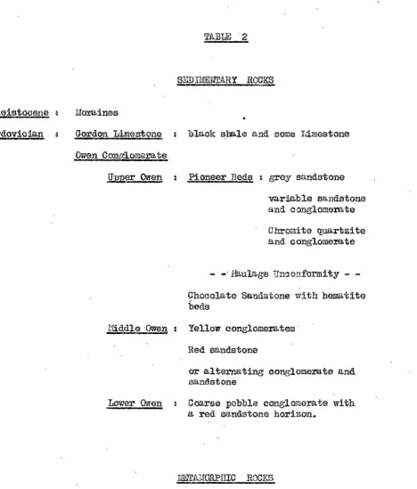
SEDIMENTARY ROOKS
1Jora.inea
Gordon Limestone blaak sba.le and some J.imestone
Owen Conglomera.te
Qimer Owen : Pi on.eer 'Beds grey s-1ndstone
variable sandstone and conglomerate Chromite quartzite and conglomera.te
- -·Haulage Un~o~formity -Chocolate Sandstone with hematite beds
1'/'dddle ·Owen : Yellow conglomerates·
Lower 0-nen
Red sandstone
or alternating conglomerate and sand.stone
Coarse pebble conglomerate with
a red sandstone horizon.
These are V'd.l'iable quartz sericite and quartz chlorite schists,
often showing relict sedimentary structures, and red ferruginous clays,
derived from the Gordon Limestone. IJ.lhe schints, known locally as the Lyell Sohists, outcrop over the ~estern slope of ·the Lyell-Owen divide and abut a~ins·I; the sedimentary rocks more or less along the divide.
The sohists represent ::i;art of the Owen Conglomera.te, the Jukes
Conglomerate and pa.rt of the Dundas beds but considerable difficulty is.
[image:13.567.40.509.48.597.2]8
-The
nvi
faults tend to occur mainly in the competent,l'.!:assive Owen Conglomerates, for in the softer, more yielding Dundas rocks, pressure is relieved by development of echistosity
with NW trend.
GEOLOOY OE' THE LYEJLL MINES
The rocks outcropping in the immediate vici~ity of the Lyell mines are summarised in Tu.ble 2; the geology of the Lyell
diB'.&rict is shown in Fig. 6, (after Solomon) while more detailed plans of the topography and geology of the mine area are shown in
Figs.
7
and 8 respectively (after Wade and Solomon). A'b.ny of the rook-unit terms have only local significance and are adopted merely ·to assist in field mapping and description. Fig. 10(after wade and Solomon) shows a generalised plan of the Lyell
orebodies~
Sedimentary Rocks Owen Con,~lomerates
The Lower Owen Conglomerates are typically coarse
siliceous conglomerates, with pebble size averaging very large or greater. The pebbles are mainly quartz, quartzite, chert, and quartz schist and show a high degree of rounding while the matrix is grey or pink quartz. Locally~ boulders of quartzite and
quartz reach a. diameter of 2 feet, and the conglomera.tes a.re
massive and poorly bedded. In the North Lyell 11nmel, 4900 feet
from the portal, a pink sandstone several £eet thick occurs in.
typical Lower Owen Conglomerate and ·this horizon appears to bave been encountered in deep bores of this vicinity. Conolly (5) regarded this as a potential ore horizon but the recent work has failed to
substantiate this view.
The Middle Owen Beds are a variable series of large pebble
conglomerates and red quartzites. Over Ml;s. Lyell and Owen, and on the Razorback ridge, a clear cut division into two units is
possible; an upper grey-yellow conglomerate and a lower red quartzite,
the Tharsis ridge, conglomerates and sandstones are interbedded,
and near Comstock it is impossible to apply the two-fold sub-division. Fig.
9
(after Solomon) demonstrates the variability of the Owen.forma.tiono
The .Middle Owen Conglomerate is a yellowish large-pebble quartz conglomerate with thin sandy beds; it grades upwards through
finer conglomerates to the Chocolate Sandstone, but shows a sharp
change at its base to red quartzite. On the Razorback ridge it is about 450 feet thick and contains coarser bands of unusual type. These are somewhat poorly sorted, lenticular, a.nd composed not only of the usual rounded quartzose pebbles, but also of Eiub-angular fragments of pink sandstone and hematite, and a few conglomerate
pebbles; this rook type is known locally as hematite conglomer~te •
. The Middle Owen Conglomerate horizon is important as in it the most
important orebodies occt1r (e.g. Nor·fth Lyell and the l{t. Lyell :rf.i.ne). The underlying red quartzite is well exposed on Mta. Owen and Lyell and on the Razorback. It is blocky but -very thinly bedded, a.nd has the grain size of a coarse sand. It is more resistant to metamorphism than the conglomer-.:i.te faoios; probably due
to it;s finer g.rain., and reJIUW.nts of' quartzite are often seen in the
adjaom1'1i schist up to 600 feet from the contact. On the Tharsis
ridge, the lower half of the Middle Owen beds are exposed but instead of the usual re4 quartzite, lenticular bands of coarse hematite
conglomerate alternate with thin beds of :red sandstone showing cross-bedcling a.nd current scouring. In sonie places the sandstone :facies
domi1-iu.tes, in others the beds are almost entirely conglomerate. These beds suggest unstable conditions of deposition, probably near a shore rich in ferruginous material. · blirther variation in the
Middle Owen lithology is seen at Comstock; nt Cape Horn the typical conglomerate and underlying sandstone are well developed, but passing towards Comstock this sub-division is lost and the i'iiiddle Owen beds
thin out and almost disappear near the mine. Once ag-a.in, the
ore-body near the surface occurs a.long the strike of the u.pper !1liddle Owen ..
Near the Comstock open cut, unusually coarse conglomerates with u dark
hernatite matrix occur in the :Otlddle Owen and similar but finer grained
10
-The U;pper Owen Conglom.e:rate is sub-divided in the Lyell
, area. by the .taul.age unconform.i ty. Below this horizon is the
Ohocola:te Sandstone, which lies oonfornably on the !diddle Owen
conglomerate. It bas basal fine conglomerates which provide a transition from the 1diddle Owen to the Upper Owen. The sandstone
is typically pink~ thin-bedded, and quartzose, with local sba.le bands _and hen:atite-rioh beds; it is characterised by "balling-up'• of
sandstone layers 'by current disturbances and by closely {B.cked
jumbles of thin zandstone tUbes lying on bedding :planes. are trace fossils and Professor Caster of the University 0£
Cincinatti has suggested in conversation that they ID!:1y represent the foosil excreta of worm colonies.
The hewtite beds are generally less than :; feet thick,
and occur some 200 feet above the b9.se of' the Chocolate Sand.stone.·
They are v1ell exposed on Pioneer Spur, where two 3 feet beds, about
10 feet a:pa.:rt, a.re interbedded wi"l;h normal pink sandstone.., They
show ·the trace fossils of the pink sandstone, but when examined by
hand-lens, can be seen to be composed of diecoida.l e~ements
averaging about l m.m. in diameter. Professor Caster, on being
shown a typical specimen, said that it resembled the Clinton iron ore, whioh is known to be o:f organic origin; an assay of a
representative :sa.mple indicated 40~ Fe203o In places the
hemtite bands ure associated wH;h grey or yellowish sandstones, as if' the iron in the latter had ~'-'ten removed and concentrated in the former .. At a number of points, re-crystallisation 0£ the iron-rich beds has produced a dense hem:1titio quartzite. This
horizon ca11 be traced from. Gormanston to l~orth Lyell and can be seen at Comstock, but on .Mts. Lyell and Owen its place is ta.ken by a
variable series of hema.titic smley sandstones and thin bedded
quartzitea.
The Haulage unconf o:rmi ty marks an interruption io Owen eedimant.a.tion and reflects movements along the L,_yell Shear. Older sedimer.i:ts were upturned and tightly folded along narrow M - S zones
and the ensuing erosion locally removed muoh of the Chocolate Sandstone.
Conglomerate at a number of placesa East of these zones of:
localised movement the Pioneer beds rest on C:hooolate Sandstone
with conformity.
The Pioneer beds rest on ·the erosional surface cut in
Chocolate Sandstone. This is generally overlain by rose-pink c011glomerate, {j!:ey sandstone, or basal hreacia which ia well exposed near North Lyell, and contains sub-angular fragments of hena ti te up to several inches in d:i.a:meJc;er, and pebbles of Chocolate Sandstone.
The conglomerate and grey sandstone are cbaraeteristic beds which usually contain tiny chromite]., grains 9 averaging
i
m .. m. di.a.meterand showi...'l'lg both rounded and sub-e.ngular f'orm. The ohz>omite
'1.W.y well be derived from a serpentine ms,ss newly exposed by the
~ulage uplift, though there is no known serpentine in the locality.
Gordon Limestone
'lthe youngest of the J?alaeozoic rooks outcropping in the mine area is the Gordon Limestone~ It is represented by
blue-black stales and. clay with local limestone lenses, and
ms
beenml:).pped ma.inly along the ea.storn side of ·t.he Lyell-Owen divide and east of' the Crown Lyell quarry; it is well exposed in the creek beds
:near Linda. The red clays, ofta'l'l. carrying wa.tive copper, tbat occur in the sy.ncl:i.na.l valleys adjacent to the Pioneer, Linda, and
Gormanston Spurs are probably derived from Gordon Limestone by
hydrothe:t"l'llCl.l alteration •.
Pleistooene
The Pleiatooene is represented by glacial moraines consisting of coo.roe boulders and f'inGr pebbles in a varved glacial clay.
'J.1hia glacial till blankets bed-rook near the Mt. Lyall ll'line and Go:manston, and near Comstock. It consists of varved clays and
boulder beds and occurs between 850 and 1500 feet above datum. 2 • At
its limits it is only a few feet thick but near Gormanston there '!Nly be over 100 feet at any one point .. The moraines mark the limit of a
distributary ice f'low of the King Glacier, and the site of an
2 ..
.An a.na.lysis of the se:i;eroted grains ga.-ve 56.lfo Cr20
3 .,
12
-ioe-da.mmed lake which overflowed &t the Gorms.nston Oap. The ice
o.:i.d. not continue beyond the Iiyell-Owen divide, as evidenced by the
complete la.ok of glacial doposi ts or physical fet.J. tures on tha western £lank of the range in this area. Again at Comstock the ice sheet did not extend very far west of the western end of Comstock Valley. A few hundred yards west of the Comstock Mines~ glacial dolerite
boulders occur a. t a ppro:rirJE, tely 1700 feet a.bov.e sea--level, suggesting that ·t;he Coms·i;ock ice wae:t thickm:- tl11111 that in the Linda Valley and exts:nded west of the Comstock £.fine.
specimen of wood in ·!;he Gormanston moraine indicates an age 0£
26 9480 :!: 800 years, placing the glaciation in 'l;he Wisconsin ,stage
(Gill (22)).
Structure
The Lyell· ores occur in rocks th;;!.t exhibit considerable
orig~l lithological differences and variation in mode of fornation, and reflect a high degree of Lower Palaeozoic tectonic instability. Minor localised movements culminated in the Devonian Tabberabber~n
Orogeny, during which the rocks were thrown into their present day
attitudes.
l'la't"lier movement phases appear to have been localised a.long the Lyell Snear, a major struotw:>e which has been the controlling factor in West Coast Ro.nge sedimentation~ the movements generally resulting in west side up displacements. Often, however, the
faulting was not simple oovement on north south axes but was
accoraplnied by displacement along east west lines and was expressed
by folding rather tmn fB.ulting ..
The earliest movement phase than can be studied in detail in the 1~yell area is that indicated by t~e !hulage unconformity and
known as the .Ehulage Movement.
The Haulage unconformity indicates west side up movemen·t
on the Lyell Shear during the earl;y- Ordovician, accompanied by
Tebbera.bbe~ Structure
The conslomerates of the Lyell area exhibit complex
folding and faulting on several wel1-de£ined lines. The chief
structural eloments identified by dotailed ~pping are those also
revealed in the regional Stir.rey i:u:d wbich 1Jave already been briefly
described.
The dominating inf~uences are west-side-north and up movement on ·l:;he L,yell Shoa:r, and vertical transcurrent MW- ·0 Vlffl/l
.faultini;-:; controlled by ·t;J:::e IJinda Disturbance; these features are superimposed on the H - S West Ooa.st IW.nge anticlinorimn.
1.£!§.il Shear displo.cement at depth, is expres$ed at the s.urface as uptu.rning and over£olding on N :... S lines, echeloned
along the Lyell-Gwen divide. The resulting structures may be studied. in Owen Conglomerate at the western ends of the Sp!l'l'S tbat finger ou·l; towards Linda :from the divide (see Fig. 7). 1'.he
mv
s·!iriking folds of these spurs are slnrply upturned toN - S trend at their ~estern ends, the upturned limb often
overturniJ--ig and exhibiting tight, smll scale folding.. Such
features a.re 1.3;ell exposed on ·this Whaleback and in the Blow open-cut;
surfa.ce exposures in the latter locality show only uniformly
wost-dipping beds, but in section on -the south-east wall of the cut, tight
isooliml folding is discernible. (See pho·bo, p:i.ge 30).
The na:!.11re of the Shear movement is indicated by the sections
in :Figs .. 11, 12 and 17; the axis of upturning gene:rci.lly dips west a.t bat\'ieen
;cP
and 50°. Conolly (5) terms th:i..s structure theRazorback fold. It is noticed that the point of upturn generally coincides with the thinning of the Owen Conglomerate.
Some difficulty ia experienced in following out the axis of the upturning on the su:rfuce. It is clear to see at many points,
:i;artiou]JJ,rly on the Whale back, T"'1nda and Pioneer Spurs but in other
aroo.s it is apparently absent, and no continuous line can be traced
a.long the divid.e. This picture of intermittent upturn is typical of the Lyell Shear and like features have been napped on a regional
scale.. It appears trat the line of upturn is interfered wlth by
14
-were active either at the same time as the L;yell Shear or slightly after it.. Conolly (5) considered the two elements combined and
could naf; be se~rated in time; he linked the l..tptuxn at the tit. Lyell Mine and at !forth Lyell by a s·!;r.:.tight line stril."ing M20°w, and described intersecting folds striking ?1201>w, and N60CV1. Actually the
upturn strikes longitudinally but outcrops intel'tlittentlyand en echelon, stepping north side westv
The gener.:tl picture ie obscured near the Mt. Lyell Mine
by the :Razorback :fault - this slices across the upturn (see Fig. 8)
and repoo..ts the stnlcture as shown by "i;he section in Fig. 11.
Other :fa.ults of near lor,gitudinal trend complicate the upturning
and overfolding associated with Iorell Shear movement.
NW and
wmr
faul ti:ng and folding combine with the !..yellShear to form the basis of the structure at Lyell. As already
described in the 1•egiore.l picture, M"l-striking high-a.ngle reverse
f~ults form a crude rift structure centred on the Linda. Valley, a.s a result 0£ the influence of the cross-cutting Linda Disturbance. With east-pitching folds at Lyell and west-pitching folds at the
eastern end of the Linda Valley a smll basin is formed which Hills ( 9)
described as the "Linda saucer".,
The Lyell-OWen divide lies on the western rim of this basin
and shows north and sou·th facing asymmetrical folds which plunge east.
111hese :folds a.re well exposed on the Pioneer 9 Lindta., and Go~nston
Spurs~ the ridges coinciding with anticlines and the intervening
valleyr.i m.rking the synclines. In this area. they trend almost
E - VI, with relatively flat south limbs and steep, u.sua.lly faulted, north limbs; together they impart a wave-like fo:rm to the conglomerates. These north-facing folds are met by south-facing features along 20000,
m:I.king the zone between 200C6 (the Whaleback fault) and ]20CS (the Pioneer fault) the lowest point o"f the ri:ft structure along the
· divide (Fig.
5).
Passing north and sooth from this area, theoonglolller~te is gradually stepped up by folding and minor E - W
f'a.ulti:ng until the Owen Spur and North Lyell faults are reached.
and south of these again the structure is repeated. with faµlts
·on 1Jft. Owen throwing down to the north and faults in the Comstock
Valley throwing down to the south.
The points of int~rsection of' these .NW and
1:: -
W faultswith the Razorback fold a:re foci for ore deposition. It is clear
from '.b"'ig. 8 that the loca:l;ion of the major orebodies is closely
related to these faults and also to the line of the Lyell She.\'.l.r
upturn and it Il'£,l,y be concluded thl.t local breecia.tion and crumpling caused by the intersection of' these two s·tructul'Gl.l elements bas
produced suitable host rook for ore deposi.tion.
It h:ls already been suggested that it is uncertain whether
the N-S and E-\V structures are contemporaneous or not, but in a feu
cases it seems obvious that the transverse structures :r.save sliced
across and displaced the line of longitudinal upturn. 'l'his is
particularly marked in the case of the lq'orth Lyell fault, vrhioh
offsets the Shear some 3500 ft. to the west on i'l;s northern. side~ ·the axis of upturn at North Lyell is displaced to the west of Cape Horn and then swings back to Comstock in a gentle curve (see Fig. 6). The lateral displacement can be explained by vertioal movement only
(see Conolly ( 5)) , but in a similar case at South Owen, a. few miles
to the south, wrenoh movement bas undoubtedly taken pl.a~e and it
seem.a probable tlat the North Lyell displacement is of similar type. As can be seen .from the section in Fig. 12 the fault also shows considerable vertical throw and the problem is whether the two types
of movement took :place in one stage of oblique slip, breaking across
the Lyell Shear; or whether there wus a phase of vertical movement
dur:lng the NW and N - S folding, followed by a later ph..~so of si~.istral wrench movement after Lyell Shear upturning. Similar rema.rks apply to several of the E - W fa:ults that appear to displuoe
the N, - S upturning in a. di:t>eoti on north side west.
The North Lyell o.:ml Owen Spur faults are narked by wide
zones of intense cri.unplin,g- and b:rcoc.iation where they intersect
16
-Comstock is a.soociated wi·th another major transverse fault (the Comstook Fault) but the opposite number on Mt. Owen lBs only minor mineralisation along its length.
Sever.a.l lines of evidence suggest f'clulting has taken :place
along the contact between aohists and conglomerate in a mun1Jer of'
places. The movement appears to vary, and involves both horizont..'1.l and vertical displacement, resultil1g in :further complications to the
structural picture. The contact seen in the vralls of the Mt. Lyell Mine open-cut rray be cited as an example of contact faulting.
Stratigraphic and Structural Control
In his regional report Solomon has shown that during Owen Conglomerate deposition, islands of Dundas rooks along the Shear
,,.
zone remained elevated and shed greywacke type detritus around their rrargins. These islands were slowly bur1ed with the Owen beds gradually overstepping greywacke detritus until they rested on origil'la:l Du..~das surfaces Fig. l] (af'ter Solomon) shows the
effect of upturning such a feature, and he applies it to the West
Lyell schist-conglomerate contact. - Similar conditions of sedimentation along the unstable, narrow Shear zone occur in the Lyell mine area.
and Solomon and the author measured a rapid thiiming of the Owen Conglomei;a:te from east to west across the mine area which e:xplD.ins
why the conglomerates appear to pass directly a.long strike into
schists, the schists representing the incompetent sheared Jukes formation or beds of the Dundas group.
It is also possible to explain in a general nanner Conolly's
"silling" of schist at North I.iyell, shown in Fig. 11 (a.); localised a.nd sudden uplift along the Iiyell Shear during O.ven deposition might
we11_-b:tve resulted in a limited. incursion of :Dundas detritus in
place of' siliceous oonglomerate1 and the softer iW.teria.1 later
being sheared to give the impression of an intrusion of schist.
Tbu.s the r:rain features of the conglomerate-schist junotion
my be explained by facies variations along strike and this alone
represents a :major breakaway from Conolly' s idea of intrusion a.nd
Bradley's theory of wholesale metasoma.tic replacement of the Or;en
However, when the oontact is emmined in detail, severa.1 a.non:alies appear that can only bo satisfactorily explained by
assuming some structural weakening leading to chemical alteration of the Owon Conglomerate. The more important lines of evidence leading to this conclusion are as follows :
At im.ny points along the con ta.et t~re is an insensible
g.rac'la.tion from sandstone and/or conglomerate through sheared mterial to schist, and the exposures leave a diGtinct impression that the sediment is being converted to schisto
On the Tbarsis Ridge (see Fig. 8), a prominent E-W fault shows a horizontal slip of almost 200 f"t. in the Owen sediments,
yet the contact 0£ schist and oonglome:ra.te on either side of the Ridge shows no displacement wh~tever. The only reasonable explana·tion for this feature is th:i.t the conglomerates have been
i:a:rtly replaced at some s·l;age af'ter faulting took place~
at the e!)uthern end of' the Tr..arsia Ridge, the Consols fa.ult coincides
with a break-through across the strike of' the conglomerates th'a.t is unlikely to be xei:la.ted entirely to facies changes.
farticularly near the King Lyell clay workings, the
sandsto~es immed~1tely underlyine tbe hydrothermally altered Gordon
sh~les are kaolinised or converted to quartz serioite schists; this is another :fea:ture suggesting hydrothermal alteration of siliceous Tiaterial, in e. NN\ff fault crush zone.
'l1he extent to which the Owen Conglomerate ha.o been
transformed is uncertain but it is undoubtedly restricted.
Possible the sohisting is confined to a narrow contact zone whGre high stress conditions prev-~iled due to friotiona.1 drag between incompetent and compe·tent naterials.
At the recent symposium on the Lyell Schists, ID1;1.ny
objections, on ohem.ica.1 grounds, were raised against the suggestion that the Owen beds had been altered, yet tra.nsforrration of quartz to sericite is mentioned by Schwartz (17), and Leedal (10) describes replacement 0£ quartz by albitc in the Oluanie igneous intr-u.~ion.
Again, fels:r:e.thisation of sandstones has been described from rrany
18
-The problem of alteration of siliceous sediments is
further discussed under the heading Lyell Sohists on ps.&.re 40.
En Echelon Structure (With Speo1.a1 Reference to West Iqell)
Formerly it had. been realised that certain groups of
ore-bodies at Lyell were arranged roughly en echelon. In particular an
en echelon arrangement of the Lyell Oomstoolc oreslloots was clearly
recognised.. Mye (12) mapped a broad scale, en echelon pattern of large zones of pyritio miner-alisation, and Conolly in a
Oo::rrr:any Report in 194911 adopted Nye's broo.d en echelon arrangement ·t;o plan drilling prospects at the intersection 0£ NVl striking zones of' mi.Tleralisa.tion and a supposed NE alignment of groups of
mineralised zones.
The control for individual ore shoots at West Lyell,
however, was not very well understood. Since most of the Oompsny•a ore 1-eserves were known to be in the West Lyell area, , particular
attention was p;i.id by the writer to oont:rol of minexalisa tion in this
ground. He was faced with the problem that here there was a
major ocourre:noe of some half million tons of copper, contained in
a lilook roughly 3000 :feet in length~ upwards of: 1000 feet in width
and economically workable to a depth 0£ 800 feet below outcrop.
ret there W'il.3 no clear general picture of ore control, no firm
outline of oreboCJ.ies, except in the case of the Royal '11ha.rsis and
the West Lyell No. l (Honeypot), and possibly the Prince Lyell, and finally no idea of what would become of these orebodies at
depl;h.
Several avenues 0£ approach were followed concurrently
in the :field and in the ofi'ice - the climate beir>.g admirably suited
for such a division of labour. At first very lHtle progress was
made in an attempt ·to map the somewhat confused and variable schist
rook ty:pee, for both boat and wall rook sohists nave nothing in
particular to distinguish them, whether barren, low grade or relatively
sedimentary renmf;l.nts in the schists, this solf-same variability (specially when examined in thin sections, or subjected to chemical analysis) branded the schists as being derived from volcanic and greywacke £a.oies, r.J.pidly altering along a·trike and alternating in succession, and belonging to the Dundas group beds.
Ti!apping of the relict sedimentary struc-tures on weathered outcrolJS
on the south-eastern ancl south.er-11 ends o:f the West Lyell Open Cut, though far from presenting a concise str~ctural picture, gave sui'f'icient evic1ence to indicate that
too
upturn axis bad been displaced westwards some 1200 feet by the steep Razorback fault(l!"'ig.' 12) and that the beds, prior to schisting, hs.d been in the vertical limb of the fold. This was the first key to an
understanding of ore control at West Lyell. Instead of West Lyell ore being away ou.t west of the ma.in zone of mineralisation, structurally and atra.tigraphically in "No ~1an's La.nd.11, it was oeen to be controlled
by the vital overturned Razorback fold. Moreover the stratigraphic succession could be interpolated on E-W seo·l:iions. This
interpretation ms airice been confirmed by diamond drilling, whore,
west of the Razorback :t"'a.ult, a drill hole passed from IJ:i..ddle Owen into
Lower Owen Conglomerate at the anticii;a.ted depth.
The field napping ~lID.lediately revealed a :r;ettern of schistosity clearly related to the '.!abbel'abberan structures. -, The schistosityaligns itself ~rallel to the
NW
fold-iailJ.t system and to the B-VI Linda Disturbance described in the regiol}9.l and mine areastructural discussions. The prevailing direction of schistosity is north-westerly, but the E-W direction is ~rticularly noticeable in and around the lloneypot, on the south end 0£ the Prince Lyell and on the north end of the 11harsis Ridge. In all cases this E-W attitude of schistosity occurs where strong E-W faults, visible at surface in the conglomerates to the east, can be projected westwards a fer1 hundred feet along strike. It is recalled here that in the discussion of :region.'3.l structure it was remarked that the ID1 faults
tend to occur mainly in the competent, nassive Owen Conglomerates,
-,20
by development of schistosity with north-west trend. Schistosity
al_igned in an E-W direction characteristically shows a rodding
effect undoubtedly developed by transcurrent movement along the
E-W faults.
Concurrently in the offioe a mathematical aIJEtlysis was
made of tens of thousands of assay results from samples taken in
·l.;he mining of the West Lyell Open Cut, and of assays from some
360,000 feet of blast-hole churn drilling and of 75,00D feet of
diamond drilling. It was fc~nd possible to accurately grade-contour
the West Lyell area at ·each bench level of the open cut and less acourately9 below the mined out area of the open cut, at 50-ft ..
vortical intervalD. The contouring showed up six Jiajor orebodies (Fig. 14), the three principal ones being the Royal Tbarsis, the IIoneypot (West Lyell No. 1) and the Prince Ly~ll, with the Prince
0
Lyell as tne largest. It is obvious from the plan view (Figa 14)
and the cross-sectional view (Fig. 15) and the longitudinal view (Fig. 16) that the group of ore-shoots is arranged en echelon.
:Each orobod.y has within it some narrow low grade zones, strung
oirt along schistosity, and ea.ah orebody also has a balo of low grade material, surrounded again by pyritic schist carrying about
0.1% Cu. The };lEl:ttcrn is typical.. of low grade dissemi:na ted ore,
with imprerrnation of cbalcopyrite starting at ~ultiple points or foci in planes of weakness (in this cane, planes of schistosity)
and spreading out until many cent:t·cs of deposition cc;a.lesoe
(Figs. 16 and
19).
1J.1he mechanism is described by Bateman (2)in his discussion of' hydrothe:rmal processes.
Referring again to Fig~ 14, it rrill bo seen that the
West Lyell orebodies, as ou·Uined by grade-contouring, not only show 1-;i, general en echelon a:rrangemenl;, as a group, but individua.l
orebodies clearly take up the two attitudes' of schistosity described
above (Fig. 8). The R~l Tharsis, West Lyell Mo.
3,
and the Prince Lyell are elor.ga ted e.long the north-went sehis·l;osi ty direction, but West Lyell 'tio. l shC>"'WG o. ~rkcd swing to an E-W direction, theschistosity here being in two well developod diraotions, one, the
When it had been established tli.a.t the West Lyell
miner~liea.tion was, as elsewhere at Lyell, mri.inly controlled by the
N-S overturned fold; that the orebodies were in sheared Dundas type
sediments. (volcanics and greywacke conglomerates) in the steeply
upturned west limb position; and. that individual ore-shoots were
arranged en echelon, in the attitude of schistosity, it vras then necessary to examine their pitch and plunge in order to plan deep drilling. (The plunge is defined as the angle between the long axis of the ore lens and its horizontal projection9 after
McKinstry (11)). As the orebodies have iiTegular outlines, and ragged ends in plan projection, their centres of gravity were determined experimentally by tracing off successive levels onto cardboard, cutting them out and suspending them from. several points successively in a vertical plane. It was found that in genera]-,
for the nest Lyell group of mines, the pitch of the centre of gravity is vertical and the plunge steep to the west.
An obvious en echelon arrangement is~ therefore, well established for the West Lyell group of orebodies ao well as i'or the Lyell Comstock group (Fig. 17) and for the large zones of
pyritic mii1eralisation rna.pped by Nye.
There is evidence of a second echelon to the Crown Lyell
orebody in the No. 4 . to No. 6 levels of the Crown Lyell Shaft.
In all these cases , as one orebody reaches the underlyi.ng schist-conglomerate con~ot another echelon becomes the na.in ore channel.
The interpretation. of this is that the schis"t;osity becomes more highly developed near ·the resistant conglomer'a.te mass, and as
the conglomerate contact dips to the south-west, so do successive
ore echelons appear, at depth, tovd.rds the south-west.
~ter12retation of Str<.1.ti~phY,¥nd S-t:ructure
(As a. pplied ·to ore search) A rrnlica tion at West Lyell
1'1rom a study of the available data., it became apparent
_,
tlmt two prospect targets were presented a:!; West Lyell. One W'd.S
22
-by far the more important one, was concerned with the 0.roll undern
or flat east limb position, at tbe base of the Owen Conglomerate.
For the first prospect, sufficient inforna.tion on s·(;ructura.l
control rad accumulated to desig11 a drilling programme to test the downward e:x.tension of known West Lyell ore. Dip and strike, pitch and plunge had been de-te:rmined and the en echelon ps.ttern enabled
drilling to be directed at ·the richer ore-shoots. Several drill
holes designed from this information ma.de satisfactory intersections on West Lyell No. 2 and West Lyell No.
3
orebodies. The inference tlla t the HoneYJ?Ot would fail at depth, as it a:pproo.ched the schist-conglomerate contact, was confirmed.. A row of six diamond drillholes was designed to cut the downward extension of the Prince Lyell
orebocly. All six drill holes intersec·ted slightly wider and richer
ore than in the open cut benches above. Two extra holes drilled outside either anticipg.ted end of the orebody failed to cut ore.
A new West Lyell d~ainage tunnel has since been driven, 700 feet below the open ~ut and this will provide drilling sites to follow the downward extension of the Prince L,yell orebody.
In the crozs-section through the West Lyell orebodies (Fig. 15), the Wost Lyell No. l orebody can be seen to be petering ~~t as it
approaches tho conglomerate. In the same section the eroded top of the Prince Lyell just outcropped. The pitch
or
the whole en echelon structure, therefore, appears to be f'l0.t to tha south-west., so ·thatindividual orebodies a.re encou11texed at suoccs:Jively- greater depths towards ·bhe south-west. This raises interest i..~ the geophysical
anomalies and the sporadic coppe? minerdlisation outcropping in the Glen Lyell area immediately to the south-was·!; of the West Lyell wa.ste dumps ..
The more important prospect will now be considered ..
Drilling for the deep i1'1•oll m1deru pI'Ospect, i. e.. the appropriate stratigraphical position in the flat east; limb of the
overturn fold axis, is by no means a. new concept a·t Lyell ..
Conolly stressed the imporlanoe of seeking for, and the likelihood of finding richer ore in :repetition. positions at depth. The
is very likely to occur, but Conolly anticipated that the repetition
wcu.ld occur
.at
a sandt:tcme horizon in the tower Owen Conglomerateinto crhich po:rphy.ry had silled and then been converted into schist, whereas the writer thinks the repetition is mu.eh more likely to occur in the schist derivatives of the Jukes Conglomera:t;e and the
Dundas Group beds, stratigraphica.lly beneath the Lower Owen Conglomerate.
In effect, this dif:ference in interpretation does not deepen the target area. very considerably. Conolly was unfortunate in that
the block of ground in which he recoIDI!lended his. "test-casen hole
happened to lie between the Wba.leback and Pioneer ftiults (Fig. 5) described on p.-:tge 14 herein as the lowest rr~rt of the rift structure. Because of te~h.~ical drilling difficulties the drill hole failed to reach the bottom of the column of' Owen Conglomerates" Conolly (5)
would have liked to seleot the North I.yell area for a deep repetition target, but the doubt a.rose in his mincl as to whether the Linda
Basin would remain as extensive in depth. It was possible, he
thought, ·!;hat the I..:inda. Ba.sin rrould contract in depth to its West Lyell core .. Again and again in hL~ prospect ·hhinki.ng Conolly
expresses the idea trot West I,yeJ.1 is located Lll the heart of the MW, mountain D'flking atructurea. This agrees with the st?uctura.1
concept already elaborated in this thesis of a crude rift valley structure (F-lg. 5); nnd West Lyell lies near the ceni;re o:f this :rif·t~ along the stril<;::e of the E-W faults.
The Wl"i her selected the block: of ground bet-.veen the King
Lyell and the Razorback faults (Fig. 5) to test the prospect zone
b(meath the I.ower Owen Conglomera.te. The c..ame prospect zone may
be seen to °tJGttox- allvantage in F1.g. 127 where also the West Lyell
ore1)odies are shown associr.'1ted. with ·the westerly displaced upturn
fold. axis. Tho orebodies figured here are regarded as "spill-outs" of low grade cha.lcopyrite which bave escaped from the stratigxaphical and struotu:ro.l ·trap position beneath the Owen Conglomerate. The copper has collected in planes of sohistosity in schists<which were
originally steeply upturned. Dundas Group beds, with possibly some
.
24
-It is sieni:fica:nt that two of the si·x: drill holes mentioned abovo wade occasio:ri...al short intersec"bions of bo:rnite, at depth, as the
drill holes approa.ohed the nose of' conglomerate shown on Fig. 12 near sea-level.; For this is near the 11roll-u:nder11 position and is the
first bo:rnite reported from West Lyell and bornite was the ore so typical of the riah North Lyell Mine.
The prospect zone selected for deep drilling beneath Weet
J.1yell has all the hall marks of favoura.ble structural and stratigraphical
ore control. It lae the strong cross faulting of the Razorback and
King Lyell faults, ·!;he displaced upturn fold axis, and finally it has the Lower Owen Conglomerate passing along strike, as it thins out 9 into
schists der;,ved :from Dundas G:f'.OUp beds and possibly Jukes Conglomerate. There is not much doubt that the block of ground between the King Lyell and Pioneer faults (Fig. 5) would be just as good a prospect. Both blocks bnve the "spill out11 ore of the operating
West J .. y~ll mines as an additional lure to deep drilling.
In the final co1.mt, initial drilling wafl designed and recommended at co-ordinate 4000 S (J.i'ig. 8) to make use of the new West Lyell tunnel for a drilling sj.te. The drill hole was designed first to thread the downward extension of the Prince Lyell echelon and then to :i;a.os on to the a.eep prospect zone 1Jenoo.th the
I1ower Owen in the vicinity of the King Lyell and Ra.zorba.ok faults.
General .Application
Should the flat east limb position be found to carry copper orebod.ies at clepth beneath West Lyell, then prospects in the same stratigraphical horizon and in similar structural positions
benea;(;h ·~he old Blow Mine, the liforth Lyell Mine and the Lyell
Comstock Mine would immediately 11come alive". The interpretation
of structural control~ as developed in this thesis, is one which ii1volves a repetition at depth (1700 to 2000 feet below outcrop)
-of' the whole o:f the i.Wount Lyell group of orebodies, which stretch over a lengl'11 o.f some
2-k
miles.A121)lica t,ioE- of Geonhysics
to the application of geophysics at Lyell as a pre-dxilling check on conclusions drawn. -For structural and stratigraphic reasons,
four a~<>ea.s wexo Gelected by the author for geophysical.' investig-ci.tion
by the Bureau of, Uine:ru.1 Resources.
The Glen I,yell Are&
Rather weak copper miner~lisation occurs at Glen Lyell at surface, and the en echelon ar1'f1r>_gement of the West Lyell group of
orebodies pointed to the Glen Lyell as the ou.tcrop of the very top of the next' echelon. The mineralisation here, as at West Lyell
:ts in ·the stei:1p upturn limb at the b.e.se of' the Owen Conglomerate. Acoo:rd.i:ngly the .13w'eau of M:inera-1 Resources was asked to oo.rry out
geophysical work in ~he Glen Lyall·area. south-westwards from the West Lyell Opon Out. Their work was extended some 2000 feet to
the south-'\vest across the Q.u.eenstovm-Gorm;;.nston road. Because of the West Lyell dumps and the E • .E.C .. high voltage power line,
- '
-the firot 700 :feat, ·the important zone for the next echelon ore body,
could not be surveyed geophysically. However, the Buxee.u did ou-Uine the southeri; end of ar1 anomaly passing in under the dump,
and other anomalies, arranged en echelon, towarcls the south-west.
One drill hole was bored into ·the firs'!:; of these, but only rich
pyrite and low grade copper were intersected- However, further
drilling is roc1uirf.ld in this area.
The Great Lyell Area
Immediately to the south of the Glen Lyell area just
described, another aree~ was select;ed for geophysical at-l:;e11tion for
structural and stratigraphical reasons~ This is the Duke and Great Lyell area (Fig.·
4).
At Great Lyell there is only a sni.all area of ou.tc:rop,
but some good copper values a.ro,quoted in old reports from a small open cut and a sh:ift 170 feet in depth. · 'I1he surrounding a.ren
is covered with glacial outwa.sh. The-workings' are in sci1ist
on the north-west end of a long ri...a.rrow ridge of Lower Owe~1 Conglomerate.
Structures mapped on this ridge show the Lyell Shear stepped across a. ahort distance to the -wee:rl;, (Fig .. 3, lf! mile:;i east of Qu.oenstown) by
26
-The Great Lyell shaft is in Lyell Schis·ts occupying th0 strn.c t-..ira.1
position of the bBse of the Oi'len Conglomerate, in the steep ,upturn
limb positiono Here again the Bureau turned in results showing an encouraging eleotro-m:i.gnetic a.noW:ily some 2000 feet in length. This ano:rrnly awaits drilling.
The Schist-Corridor l.1.1:00
(North-west from the Crown Lyell Quarry)
It baa been mentioned b@lforc that an examina·tion of the
North Izy-ell level plans i.'l'ldicated ·t;hs.t an echelon orebody could be expected to occur north of the old Ea.stern Orebody. Its outcrop would be concealed by detritus from the North Lyell fault scarp and
there would be :no underground. workings near its position at depth., Any expected ore here would be of the low grade chalcopyrite type in
planes of schistosity and occurring in schist o.long strike of the
I:liddle Owen upturned beds ..
movement of the Lyell Shear by the very strong North Lyell
fault was some :;500 feet westv.ards, wi. th the south block down some
GOO feet.. Such intense movement caused a high degree of' rook
deformation, (as encountered in the llorth Lyell t:li.ne). Once
again the Dureau W"~s called upon to verify previous geophysical
work (Ec1uipo·tential Method) by up-to-date Tura.m and Self Potontion
methods. Again a very strong anomaly, 2000 f'eet in length, was
outlined a.long the North Lyell :fault zone.
A current drilling programme is intersecting new chalcopyrita and pyrite ore in a grey.quartzite lode along this
anomaly.
Comstock
A fourth area selected on structtn'al grounds £or work by the :Uure9-U geophysioists is at Comstock .. The area is covered
by Pleist-ocene glacial till but contains some known dense oulphides of lead, zinc, copper and iron. It is situated where the
E-W Comotock fault intersects the Lyell Shear in the zone where
gre;ywack0 type sediments. 1.rhe
Co.'!1stook copper orobodies a.re some 800 feet ·to the north west. In this case a \vide anomaly,
1500 feat in length, was recorded. It has been provisionally
interpreted as o.ue to deep seated mineralisati'on.
In all four cases cited, strong geophysical anomalies
have been recorded, due to s~lphide mineralisation at places where · good structural control for ore was know11 to occur. and where lit'lile
or nothing was known about sub-surface mineralisa.tion.
Geology of the Individual .Mines
A desc~iption 0£ the individual mines at Mount Lyell
is now given to illustr.a.te size, grade ancl nature of ore as affected
by the va.2"ious structural controls.
Bornite-Gralcon:vrite Orcbodies
North Lyell Mine
Grade, Production and Reserves
Nor·th Lyell ore averaged
5.4%
Cu. a.nd the mine produced 200 tons of copper per vertical foot (c.f. the Mt. Lyell Fline 120 tons, and West Lyell 700 tons per vertical foot).Between
1903
and1953
the mine produced4,642,860
tonsof ore assaying
5.4%
Cu., l.12 ozs. Ag. per ton, and 0.01; ozs. Au.per ton.
The mine ceased production in 1953 and p11blished reserves
are 3000 tons of 3.6% Cu. ore underground., and 2,500,000 tons of
o.~ ore available for open cutting.
Geology
At ou.tarop the ore is in a schist corridor, 1200 feet
wide, and about midway between the conglomerate masses of r!Iount Lyell
and the Tb:i.rsis Ridge. A-b depth the ore impinges onto, and at placez is actually in, J::ard conglomerate. The ge:nera.1
28
-A notable feature of the North Lyell mine is the presence of large ii:assos of buff-coloured chert veined by heriatite. Jfir. Hudspeth, l'JI..ine Superintendent for the Mt.
Lyell Com:i;nny, states that the buf'f chert stopes were entirely
cbalcopyrite ones. environments, viz .. :
The bornite occurred in three different
(a) Grey quartzite containing appreciable
quantities of pyrite and little or no chalcopyrite.
(b) White or grey schists with little or no py-.l'ite.
(c) In the conglomerate as solid bornite with no vi3ible gangue and no chalcopyrite.
At depth the orebodies lie flatly, controlled by the attitude of the original bedding, but :pass vertically up ·through
the fold axis until they become small vertical pipes in the
steeply upturned beds (see Fig. ll(a)). Ore occurs in the upturned and replaced Middle Owen Conglomerates occupying the
vertical limb of the Razorback fold immediately south of the
North Lyell fault zone.
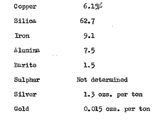
The ore was minly bornite in a siliceous gangu.e, with cl:ia.lcopyrite, pyrite, galena, hena.tite, and barite. A
typical analysis is given in Table 3. The gold and silver
values were below those at the Blow, but higher than in the
orebodies away from the schist conglomerate contact. Soma
of the stopes were phenomenally rich in bornite, having many
thousands of' tonrJ of ore averaging over jO'/o Cu. Some o:f the
rich bornito ore ba.s recently been found to be weakly radio-active
due to the prosence of a small amount of uranium (umnium mineral not de·t;ermined). The vertical extent of the various ore-shoots
was very variable. At depth they merged to form a large irregu.la.r orebody and then separ...i.ted out aeain in the bottom 0£
the mine.
i..vicomplete, due to lAok of information at depth. There mu.st have been some channel for upward passage of copper bearing
solutions along the North Lyell fault zone.
Tue
~ or the BlowGrade ,
J?!oduction
'ari.d ·Reserves
The first one and a half million·tons of ore extracted from the Blow averaged 2.85'~ Cu., 2.67 ounces of.silver, and
o.
095 oun~es of gold. per ton, but the grade d.eclined with depth. '.After a~lganiation with North Lyell in 1903 the ore averaged less
tha.n 1~ Cu. and ore now, i..'l'l reserve in tho bottom of the mine
Offic~l production figures are :
~I -i
1868-89:
1875
tons of ore yieiding1670
ozs. ~£ "•1 gol4, 852 ozs. of silver together worth
£6,159 ..
2 .. 1896-1929:
Ou., 2.0 ozs. of silver per ton, and 0~065 ounces of gold par ton.
Ore reserves were last quoted in 1924 as 1,642,122 tons assaying 0.5~ Cu., 1~5 ozs. Aga per ton, ~nd 0.04 ozs. Au. per ton.
In the following five yearn, until tho mi11e closed in 1929, only
17,000 tons of this reserve were. mined.
The Blow occupies a similar structural and stratigraphic position to the North Lyell orebodies. The ore occurs in schist occupying the position of the 1l'liddle Owen Conglomerate in the vertical limb of th~ Razorback upturn. The orebody
lies between the <Jrushed zones of the Gormanston and Owen Spur f'au.l ts , the e.ohist penetration along ·the 'owen. Spur fault at
. '
I
- ,o
-s rp contact -seen on t e southern 11 of the low open cut
y well repre t a west dipping fault of the upturned limb.
(~ e photo). The orebody s roughly lliptical and r ohed
BLOW OPEN CUT LOOKING S .E...
maximum on o.
4
1 vel where it was 660 feet in length nd210 feet in width; it was worked to depth of 800 feet. In
cross section (see ig. 11), it s ped like a banana, the