"I
GiJEOUS ROCKS, CEIHRAL PLATEAU" by F.L. SutherlandTasmanian r•lus eum, Hobart
Igneous rocks of basic character dominate the Central Plateau. A great dolerite sheet of Jurassic caps the Plateau and forms its resistant surface. Later, sporadic basalt lavas of Tertiary age fill old drainage depressions cut in the Plateau. The dolerite is far more voluminous, but less varied in its chemical composition (approx. 1500 cu. km; silica range 52-60"o) than the basalts (approx. 15 cu. km; silica range 36-53%).
Both these rocks express important events which affected the Southern Hemisphere. The dolerite is the vast molten response to initial fracturing of the southern supercontinent, Gondwanaland, of which Tasmania is a small fragment. The basalts form part of the eastern Australian volcanic province which erupted in response to warping, stretching and increased heat flow along the continental margin as sea-floor spreading opened up the Tasman Sea and Southern Ocean, beginning about 85 million years ago.
JURASSIC DOLERITE Its Structure
The dolerite sheet was probably intruded about 165 million years ago (McDougall, 1961). The sedimentary roof rocks, nm~ largely stripped a\'Jay, form remnants that are baked at the dolerite contacts, with sandstones converted to quartzites and mudstones to cherty hornfels. The dolerite upv<elling was accompanied by block faulting. One of the
largest movements forms the north-westerly trending Tiers fault that bounds anJ. uplifts the Plateau rocks by some
600m (I!cKellar, 1957; Carey, 1958a; Sutherland, 19G6; Longman and Leaman, 1971).
44
intrusion. However, south and north of the Plateau and east of the Tiers Fault separated sheets appear (Prider, 1948; Fairbridge, 1949; Longman and Leaman, 1971).
Peripheral feeders for the Plateau dolerite may exist at Long Lake, Mt. Gell, Little Billop and Mt. Arnon (MacLeod
et. aZ.,
1961; Gulline, 1965; Longman and Leaman, 1971). South-east of Waddamana, a dolerite dyke occupies the Nelson Bend Fault and extends to the east as an extensive sheet (Fairbridge, 1949), but whether this is upstepping of a lower sheet or is a feeder rising from the basement is uncertain. Small dolerite intrusions in the Nive River near Bronte have locally dragged the intruded Triassic beds (Gulline, 1965). Later faults disrupt the dolerite in places, but movements are difficult to estimate where only dolerite is juxtaposed. Intersecting patterns of joint and fault lineaments have been mapped in the dolerite from aerial photographs (Prider, 1948; Voisey, 1949 a,b; Fairbridge, 1949; Blake, 1956; McKellar, 1957; Jennings,et. aZ.,
1961; Gulline,et. aZ.,
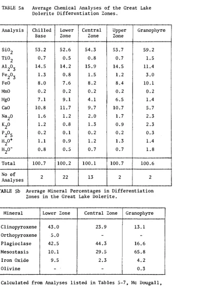
1963). Its PetrologyThe dolerite is silica saturated rock (tholeiite). Chilled, fine grained rock at the intrusive contacts passes up into coarser grained rocks which vary in mineral content and correspondingly in chemical composition. Hydro Electric Commission drilling for the Great Lake-Poatina scheme
provided cores for detailed study of these variations (Joplin, 1957; McDougall, 1958, 1964). These variations resulted from fractional crystallization during cooling of the thick magma, by gravity settling of crystal aggregates and upwards concentration of the volatile-bearing residual components. This process produced large scale vertical -zonation in the dolerite, gradationally forming the lower, central and upper differentiation zones (Table 1).
The dolerite contains variable proportions of pyroxene and plagioclase feldspar interspersed with iron-titanium oxides and a late-stage silicic, glassy to incipiently crystallized groundmass residue (mesostasis). The lower zone typically shows pyroxenes (orthopyroxene, augite and pigeonite) in excess over plagioclase (bytownite), with only minor mesostasis. The coarser central zone has
TABLE Sa Average Chemical Analyses of the Great Lake Dolerite Differentiation Zones.
Analysis Chilled Lower Central Upper Granophyre Base Zone Zone Zone
Si0 2 53.2 52.6 54.3 53.7 59.2
Ti0 2 0.7 0.5 0.8 0.7 1.5
Al 2
o
3 14.5 14.2 15.9 14.5 11.4Fe 2
o
3 1.3 0.8 1.5 1.2 3.0FeO 8.0 7.6 8.2 8.4 10.1
MnO 0.2 0.2 0.2 0.2 0.2
MgO 7.1 9.1 4.1 6.5 1.4
CaO 10.8 11.7 9.7 10.7 5.7
Na2
o
1.6 1.2 2.0 1.7 2.3K2
o
1.2 0.8 1.3 0.9 2.3P205 0.2 0.1 0.2 0.2 0.3
H
o+
2 1.1 0.9 1.2 1.3 1.4
H
o-2 0.8 0.5 0.7 0.7 1.8
Total 100.7 100.2 100.1 100.7 100.6 No of
2 22 13 2 2
Analyses
TABLE
sb
Average Mineral Percentages in Differentiation Zones in the Great Lake Dolerite.Mineral Lower Zone Central Zone Granophyre
Clinopyroxene 43.0 23.9 13.1
Orthopyroxene 5.0
-
-Plagioclase 42.5 44.3 16.6
Mesostasis 10.1 29.5 I 65.8
Iron Oxide 9.5 2.3 4.2
Olivine
-
-
0.3 [image:3.556.40.452.115.676.2]4&
The resulting variations in chemical composition of the zones is illustrated in Table 5 by average analyses :flam 41 Great Lake dolerites (McDougall, 1964). The analyses demonstrate decreasing amounts of early crystallizing
constituents (Mg, Ca) in the lower zone to increasing later constituents (Si, Al, Na, K) in the central zone. East of Inlet Trig on·the eastern shore of Great Lake, the dolerite shows extreme differentiation into the silicic end product, granophyre. 11ere, residues streamed up into
a structural high and then crystal1ized rapidly with loss of volatiles ti1rough the fractured roof.
TI1ese variations in the Great Lake dolerite are also reflected in measurements of the density and magnetic components in the rocks (Jaeger anc.l Joplin, 1955; Jaeger and Green, 1958; Jaeger, 1964). Trace element studies on the Great Lake dolerite (Heir, Colilpston and i,lcLJougall, 1965) show Th, U, K, !Zb and Sr isotope ratios more typical of crustal Tacks than basic magma generated in the eaTth's mantle. This suTpTising Tesult suggests either an unusual contamination of the magma oefoTe ascent OT a mantle source of unusual composition undeT Tasmania.
Its Cooling_ and_ Subsequent H~sto_Ey
On intrusion at tempeTatuTes close to ll00°C: C•lcDougall, 1958), t11e dolcri te would itavc solidified and cooled oveT an extended peTioJ of tiLle. Calculations suggest that the main sheet woulJ take between 1,000 and 1, 500 yeaTs to solidify, compareJ v,i th up to 20,000 years for solidification of the tllick central part, \vhile about 100,000 yeaTs would oe needed for the main sheet to cool
down to. tempcTatures of about 200°C (D.E. Leaman, peTs. conm1.). The chaTacteTistic columnar jointing of the dolerite
includes cooling joints, but these are difficult to distinguish fTom the jointing due to lateT uplift (Carey, 1958b; Hale, 1958).
Secondary minerals now fill joints, cavities and alteration zones in the dolerite and include calcite, clays, zeolites, and chloritic materials e and Spry, 1964). Some of these may have formed from final-stage fluids escaping from the consolidated dolerite, Lut others formed well after cooling and jointing, some perhaps
forming during later regional heating of Tasmania to temperatures up to 200°C.
TERTIARY BASALTS
Lavas,explosive deposits and vents form a scattered record of Tertiary volcanism on the
Central Plateau. The basaltic types encompass the ividest range known in Tasmania and includes some rare rocks. The volcanism has been thought to include some comparatively young eruptions, probably Pliocene or younger, but recent isotope (K/Ar) measurements on some of the lavas gave mid-Tertiary ages and upset this notion. The basalts conveniently separate into (a) isolated, strongly undersaturated plugs, (b) restricted unsaturated lavas and (c) iddespread lavas forming piles dominated by saturated basalts. The range in cllcmi of the rocks is illustrated by the analyses listed in Table 6, some
of \~hici1 are previously unpublished.
These form SJ:mll conical !1ills r1s1ng above the dolerite surface at Shannon Tier and east of Laughing Jack : Iarsh. They ar•rear to represent completely denuded volcanoes that existed prior to the mid-Tertiary flmv sequences. Recent magnetic measurements on the Shannon Tier plugs gave a steep Iilagnetic inclination (with normal magnetization) that suggests a Lower Tertiary age (Wyatt,
1971).
The Shannon Tier rocks are cclebratecl for their rare petrology (bl1~ards, 1950) and luckily were amongst the earliest basalts investigated in Tasmania (Twelvetrees, 1902). Tltc outcrops are descriptively named The liaystack, Beehive and Anthill and are composed of olivine-monticelli
te-nepheline melelitite rock (Analyses 2-4). The largest plug shm;s coarser patches of late-stage zeoli tic rock. The unusual nineralogy of tile plugs reflects the very low
TABLE 6. Analysis Number Si02 Ti02 A1 2o3 Fe2o3
FeO MnO MgO CaO Na20 K20 P205 H20+
H20-co2
TotalChemical Analyses of Central Plateau Tertiary Volcanic Rocks.
1 37.1 2.6 9.3 4.1 9.0 0.2 15.9 12.8 3.7 1..4 1.3 1.9 99.3
Strongly Unsaturated Plugs 2 36.0 1.1 15.2 5.9 9.6 0.2 8.6 15.5 4.2 1.9 1.4 0.6 100.2 3 36.2 2.2 11.9 11.4 4.2 14.2 11.5 5.4 2.1 0.8 99.9 4 37.6 3.8 15.3 5.6 6.7 0.3 4.8 14.1 3.8 0.9 1.0 5.6 1.2 100.7
Unsaturated Lavas
5 43.9 2.4 12.9 4.7 7.9 0.2 8.3 8.2 3.8 2.2 1.4 3.1 99.0 6 46.8 2.5 13.7 5.2 7.3 0.2 8.7 7.2 4.2 1.7 0.9 1.0 99.4 7 46.8 2.7 14.1 3.3 8.9 0.2 7.0 7.7 3.2 1.8 1.0 2.7 99.4
Saturated and Transitional Lavas 8 48.6 1.8 13.9 2.4 9.9 0.2 8.6 8.2 2.7 0.8 0.3 0.7 1.2 0.3 99.6 9 50.1 1.8 13.6 2.5 9.1 0.2 8.3 8.6 2.4 0.5 0.3 1.0 1.2 0.2 99.8 10 51.5 1.6 14.2 1.1 10.2 0.2 7.1 8.5 2.5 0.9 0.2 0.7 0.4 0.9 100.0 11 52.3 1.7 14.2 1.4 9.5 0.2 6.9 9.3 2.5 0.6 0.2 0.3 0.8 0.2 100.1
1. Olivine Melelitite, E. of Laughing Jack Marsh, Bronte; 2. Monticellite Olivine Nephelinite, Shannon Tier; 3. Olivine Melelitite, Shannon Tier; 4. Melilite Fasinite, Shannon Tier; 5. Mafic Feldspathoidal
Mugearite, E. of the Nipples, W. of Antill Ponds; 6. Mafic Mugearite 3 kms. NE of Interlaken; 7. Limbur-gitic Basalt, Dogs Head Point, Lake Sorell; 8. Transitional Olivine Basalt, top flow, Liawenee Hill; 9. Tholeiitic Olivine Basalt, Flow Foot Breccias, SE Canal Bay, Great Lake; 10. Tholeiitic Olivine Basalt, E. of Shannon Lagoon; 11. Tholeiite, S. bank, Ouse River, Skittleball Plains. Analyses l, 5-7 P. Beasley and E. Kiss, Australian National University, Analyses 2-4 from Edwards (1950), Analyses 8-11
[image:6.810.125.687.81.389.2]crystallization of the undersaturated calcium silicate minerals monticellite and melelitite.
The Laughing Jack Marsh outcrop has only been located recently and is olivine-melelitite (Analysis 1). It differs from the Shannon Tier rocks in containing common inclusions of peridotitic rock (lherzolite) which probably represent accidental fragments brought up from the earth's mantle. It is one of the most basic volcanic rocks yet found in the Australian Tertiary.
Unsaturated Lavas
These lavas are mainly found on the SE side of the Plateau, where they were mapped by Nye (1921), but some also fringe and intersperse with the saturated lava
sequence further west. The flows are associated with some plugs and the rocks fall into two associations, normal alkaline olivine basalts and more alkaline rocks. Many of the rocks, particularly the alkaline ones, contain peridotitic inclusions brought up from the mantle.
Typical examples of the normal alkali basaltic rocks include the basal flow of the Lake Echo sequence, some flows around Lake Augusta, that descended into the Liawenee sequence (Sutherland and Hale, 1970) and the limburgitic basalt at Dogs Head Point, Lake Sorell. This last rock
(Analysis 7) carries large crystals of clinopyroxene, crystallized and brought up from depth.
The alkaline rocks commonly contain sodic plagioclase (oligoclase) and includes some unusually mafic types that have only been sparsely recorded in the world literature from a few scattered localities. They include nepheline and analcite mugearites (Analysis 5) and mafic mugearites (Analysis 6), as well as types grading to basanites and potassic olivine nephelinites or to more normal mugearites that lack peridotitic inclusions and are more typical of types evolved by fractionation of magma at higher levels in the crust.
Saturated Lavas
These form by far the most abundant flows on the Plateau. Their repeated eruption filled old valleys of the Nive, Ouse and Shannon Rivers with lava sequences
50
Fairbridge, 1949; Voisey, 1949a; Jennings, 1955). The laras mainly cooled into massive, commonly columnar flows with scoriaceous surfaces, but where they plunged into
rirers, ponded drainages or lakes the resultant extra chilling ptDduced characteristic lava forms.
Minor developments of water-cooled lavas are exposed in the Nive sequence on the Lyell Highway, but the most extensive developments occupy the lower parts of the Great Lake depression, suggesting eruption into old lakes. The rocks take two main forms, bedded water-laid tuffs (hyaloclastites) and dipping flow foot (pillow) breccias. The tuffs contain glassy shards scattered by steam explosions as water contacted molten lava and they show current scoured bedding and soft sediment deformations arising from loading, slumping and sliding. They represent emergence of volcanic vents above lake waters and pass
upwards into the next phase during which flow foot breccias erupted. The breccias are spectacular rocks in which lobes of lava with glassy cooling crusts have been broken up and embedded in a matrix of glassy fragments. They formed when lavas from emerged"vents plunged down from air into water, building out successively into lava deltas radiating out from the vent. Finally, when these deltas emerged subsequent eruptions formed normal air cooled lavas that cap the sequence.
These sequences were particularly well exposed by the drastic fall in the Great Lake water level during the 1967-68 drought (Sutherland and Hale, 1970), but have since been re-drowned. An older series of flow foot
breccias, however, is exposed in the banks of the Ouse Riyer and in Liawenee Canal and is conspicuously infiltrated
by secondary minerals. The mineral assemblage included calcite, apophyllite, zeolites (chabazite, phillipsite), clays (nontronite) and hydrated calcium silicates, notably the extremely rare unstable species tacharanite and its breakdown products (Sutherland, 1965; Sutherland and Hale, 1970).
the Liawenee sequence (22.9 m.y.), the flow capping Reynolds Island (22.3 m.y.), a dyke cutting flow foot breccias on Reynolds Island (21.8 m.y.) and the flow capping
hyaloclastite tuffs and baked Tertiary sediments from Tods Corner to Shannon Lagoon (21.8 m.y.). This indicates eruptions from at least Late Oligocene into earl
Miocene times. Some magnetic measurements on the dated lavas show largely normal magnetization with magnetic inclinations typical of expected from rocks with mid-Tertiary ages.
The eruptive points for the saturated flow sequences are mostly unexposed, except at Great Lake INhere several vents suggest fissure eruptions located on
intersecting lineaments (Sutherland and Hale, 1970). A few possible feeder dykes have been suggested in the Nive Valley north of Tarraleah (Prider, 1948) and a possible
plug lies NW of Bronte Park (Gulline, 1965). Petrographically the lavas include tholeiitic and transitional olivine basalts and true orthopyroxene-bearing tholeiites (Analyses 9-11), with the most saturated basalts approaching compositions similar to that of the Jurassic dolerite.
Later faulting of any significance does not seem to have disturbed the basalt piles. Fairbridge
(1949) thought that post-basaltic faulting may have formed the Lake Echo depression, based on the apparent absence of any filling basalts. However, a small flow remnant recently located west of Lake Echo Farm and well below the main basalt outcrop makes this uncertain (Sutherland, 1971). This remnant resembles the top tholeiitic olivine basalt capping the succession to the east and suggests overtopping down into the Lake Echo depression.
CONCLUDING STATEi·lENT
The igneous rocks of the Central Plateau are all mafic in character, but provide an interesting comparison in behaviour of mafic magma introduced in large voluminous intrusions and in smaller scattered volcanic eruptions.
52
REFERENCES
Blake, F.,
et. aL., 1956: Great Lake. 1-mile Geol. Map
Ser. N°
53.Mines Dept. Tasm.
Carey, S.W., 1958a: The Isostrat, a New Technique for the
Analysis o£ the Structure of the Tasmanian Dolerite
in
DoLerite Symposium, Univ. Tasmania, pp.
130-164., 1958b: Note on the Columnar Jointing in Tasmanian
Dolerite,
ibid., pp. 229-230.
Edwards, A.B.,
1950:The Petrology o£ the Camozoic Basaltic
Rocks of Tasmania.
Proc. roy. Soc. Viet ... 62, pp. 97-120.
Fairbridge, R.W., 1949: Geology of the Country around
Waddamana Central Tasmania.
Pap. Proc. roy. Soc. Tasm.,
(1948), pp. 111-151.
Gulline, A.B., 1965: St. Clair
ExpZan. Rep. GeoZ. Surv.
Tasm. 1-mile Geol. Map Ser. K/55-10-59.
, et. aZ., 1963: St. Clair 1-mile Geol. Map Ser.
K/55-10-59.Mines Dept. Tasm.
Hale, G.E., 1958: Some Aspects of Jointing and Decomposition
in Tasmanian Dolerites in
Dolerite Symposium, Univ.
Tasmania, pp. 184-196.
, and Spry, A.H., 1964: Cave in Dolerite at Wayatinah,
Tasmania.
J.geoL. Soc. Aust., 11, pp. 213-216.
Heier, K.S., Compston,
w
.•
and McDougall,
I., 1965: Thorium
and uranium concentrations and the isotopic compositions
of strontium in the differentiated Tasmanian dolerites.
Geoahim. Cosmoahim. Acta, 29, pp. 643-659.
Irving,
E., 1956: The Magnetization of the Mesozoic Dolerites
of Tasmania.
Pap. Proa. roy. Soc. Tasm.,
90,pp. 157-168.
Jaeger,
J.C., 1964: The Value of Measurements of Density
in the Study of Dolerites.
J. geot. Soc. Aust.
1, and Green, R., 1958: A Cross-Section of a Tholeiite Sill in
Dolerite Symposium,
Univ. Tasmania, pp. 1-19., and Joplin, G.A., 1955: Rock Magnetism and the Differentiation of Dolerite Sills.
J.
geoZ. Soc.
Aust.,
2, pp. 1-19.Jennings, I.B., 1955: Geology of Portion of the Middle Derwent Area.
Pap. Proc. roy. Soc.
Tasm.~ 89, pp. 169-180., 1963: Middlesex.
Explan. Rep. GeoZ. Surv.
Tasm.
l-mi1e Geol. Map Ser. K/55-6-45., and Burns, K.B., 1958: Middlesex. 1-mi1e Geo1. Map Ser. K/55-6-45. Mines Dept. Tasm.
, et. aZ.
1961: Du Cane. 1-mi1e Geo1. Map Ser. K/55-11-52. Mines Dept. Tasm.Jones, B.F., Haigh, J. and Green, R., 1966: The Structure of the Tasmanian Dolerite at Great Lake.
J.
geol.
Soc. Aust.,
13, pp. 527-542.Joplin, G.A., 1957: The Problem of the Quartz Dolerites: Some Significant Facts Concerning Mineral Volume, Grain Size and Fabric.
Pap. Proc. roy. Soc. Tasm .•
93, pp. 529-549.
Longman, M.J. and Leaman, D.E., 1971: Gravity Survey of the Tertiary Basins in Northern Tasmania.
BuZZ. geoZ.
Surv.
Tasm.~ 51.McDougall, I., 1958: A Note on the Petrography of the Great Lake North Sill. in
Dolerite Symposium,
Univ.Tasmania, pp. 70-76.
1961: Determination of the Age of a Basic Intrusion by the Potassium-Argon Method.
Nature., Lond.
190, pp. 1184-1186., 1964: Differentiation of the Great Lake Dolerite Sheet, Tasmania.
J.
geoZ. Soa. Aust.
11, pp. 107-132.54
tviacLeod, W.N._. et al., 1961: Du Cane. E'xp Geol. Surv. Tasm. 1-mile GeoL Map Ser. K/55-11"·52.
Nye, P.B., 1921: ~·lidlands.
The Underground Water Resources of the . flat. Resour. Pap .. 'l'asm ... 1.
Prider, R.T., 1948: The of the Country around Tarraleah, Tasmania.
Pap. Proc. Soc. 'I'asm., (1947), pp.l27-l50. Sutherland, F.L., 1965: Some New Occurrences of Zeolites
and Associated Minerals in the Tert Basalts of Tasmania. Aust. J. Sci., 28, p. 26.
, 1966: Considerations on the Emplacement of the Jurassic Dolerites of Tasmania. Pap. Proc. roy. Soc. Tasm., 100, pp. 133-146.
, 1971: The Question of Late Cainozoic Uplifts in Tasmania. Search~ 2, pp. 430-431.
, Green, D.H. and Wyatt, B.W., 1972: Age of the Great Lake Basalts, Tasmania, in Relation to Australian Cainozoic Volcanism. ,J. geol. Soc. Aust., in press. and Hale, G.E.A., 1970: Cainozoic Volcanism in and around Great Lake Central Tasmania. Pap. Proc. roy. Soc. 'l'asm., 104, pp. 17-32.
Twelvetrees, IV.H., 1902: Report on deposits of opal at Bothwell and an alleged discovery of gold at Hunterston on the Shannon. Rep. Secy. Min. 'l'asm.
(1901-1902), pp. 252-259.
Voisey, A.H., 1949: The Geology of the Country Around the Great Lake, Tasmania. Pap. Proc. roy. Soc. 'l'asm.~
(1948), pp. 95-104.
1949: The Geology of the Country between.Arthurs Lakes and the Lake River, Tasmania. Pap. Proc. roy. Soc. 1'asm . ., (1948), pp. 105-"110.
Wiebenga, W.A. and Polak, E.J., 1969: Great Lake North. Engineering Geophysical Surveys Tasmania 1951-1959.
BuZZ. Bur. Min. Resour. Aust. 101.
Wyatt, B.W., 1971: Palaemagnetism of the Tasmanian Cainozoic Basalts. Univ. Tasmania Hans. 'Thesis