Understanding the World: High
Level Perception Based on Spatial
and Intuitive Physical Reasoning
Peng Zhang
A thesis submitted for the degree of
Doctor of Philosophy
The Australian National University
Except where otherwise indicated, this thesis is my own original work.
Parts of the material in this thesis has previously appeared in the following publications:
Table 1: List of chapters that consists of past publications
Thesis Chapter Publication Title Publication Sta-tus
Candidate’s contribution
Chapter 3 From Raw
Sensor Data to Detailed Spatial Knowledge.
In IJCAI’15 Principal author. Jae Hee Lee helped with formalizing prob-lems. Jochen Renz helped with designing experimental environ-ment
Chapter 4 Trend-Based
Prediction of Spatial Change
In IJCAI’16 Equal contribution author. Xi-aoyu Ge designed algorithms on matching spatial regions at different states, and obtaining the outer approximation of the
changes. Jae Hee Lee
im-plemented Kalman Filter and helped with formalizing prob-lems. Jochen Renz designed a qualitative reasoning method for region matching and helped with formalizing problems.
Chapter 5 Qualitative
Spa-tial Representa-tion and Rea-soning in Angry Birds: the Ex-tended Rectan-gle Algebra
In KR’14 Principal author. Jochen Renz
helped with formalizing prob-lems and refining the qualitative representation and rules
Chapter 6 Support
Rela-tion Analysis for Objects in Multiple View RGB-D Images
under submis-sion to IJCAI’18
Principal author. Xiaoyu Ge helped with designing and im-plementing static equilibrium for force analysis, and helped with performing experiments. Jochen Renz helped with formal-izing problems
Acknowledgments
First, I would like to express my sincere appreciation to my supervisor Professor Dr. Jochen Renz for his continuous support and encouragement during my Ph.D. study. It is my fortune to have such a supervisor who provided invaluable advices and support to my research and career, and showed warm care to my life like a family.
I would like to thank the Australian National University and Australian govern-ment for offering me scholarships to cover my living cost and tuition fee. I also thank IJCAI, KR, ECAI and ARC for providing me grants for attending conferences.
I would like to thank my colleagues and friends Xiaoyu Ge, Matthew Stephenson and Hua Hua for the uncountable interesting discussions and the late nights we were working together before the deadlines.
I would like to thank Dr. Jae Hee Lee for the help on mathematics and the advices on my research.
My thanks go to all my families for the love and solicitude.
Finally, I would like to show my deepest thanks to my parents for their endless love and unconditional support throughout my life. And to my beloved wife, thank you for your understanding and patience, for accompanying me in the sleepless busy nights. And most of all, thank you for being my best friend.
Abstract
Artificial intelligence (AI) systems that can interact with real world environments have been widely investigated in the past decades. A variety of AI systems are demonstrated to be able to solve problems robustly in a fully observed and controlled environment. However, there still remain problems for AI systems to effectively anal-yse and interact with semi-observed, unknown or constantly changing environments. One main difficulty is the lack of capability of dealing with raw sensory data in a high perceptual level. Low level perception cares about receiving sensory data and processing the data systematically so that it can be used in other modules in the system. Low level perception may be acceptable for AI systems working in a fixed environment, as additional information about the environment is usually available. However, the absence of prior knowledge in less observed environments produces a gap between raw sensory data and the high level information required by many AI systems. To fill the gap, a perception system which can interpret raw sensory input into high level knowledge which can be understood by AI systems is required.
The problems that limit the quality and capability of perception of AI systems are multitudinous. Although low level perception which concerns data reception and pre-processing is a significant component of a perception system, in this work, we focus on the subsequent high level perception tasks which relate to abstraction, representation and reasoning of the processed sensory data. There are several essential capabilities for high level perception of AI systems for analysing the requirement of critical information before a decision is made. First, the ability to represent spatial properties of the sensory data helps the perception system to resolve conflicts from sensory noise and recover incomplete information missed by the sensors. We develop an algorithm to combine raw sensory measurements from different view points of the same scene by resolving contradictory information and reconcile spatial features from different measurements. With spatial knowledge representation and reasoning (KRR), the ability of inferring and predicting changes of the environment from current and previous states will provide further guidance to the AI system for decision making. For this ability, we develop a general spatial reasoning system that predicts the evolution of constantly changing regions. However, in many situations where the AI system needs to physically interact with the entities, spatial knowledge is necessary but not sufficient. The ability of analysing physical properties of entities and their relations in the environment is required. For this task, we first develop a 2-dimensional reasoning system that analyse the support relations of rectangular blocks and predict the weak part of the structure of blocks. Then, we extend this idea to develop a method to reason about the support relations of real-world objects in a stack using RGB-D image data as input. With the above mentioned capabilities, the perception system is able to represent spatial properties of entities and their relations as well as predicting their evolutionary trend by discovering hidden information from the raw sensory data. Meanwhile, for manipulation tasks, supporting relations between objects can also be inferred by combining spatial and physical reasoning in the perception system.
List of Publications
• Zhang,P.andRenz,J., 2014. QualitativeSpatialRepresentationandReasoning
inAngryBirds:TheExtendedRectangleAlgebra. InKR2014,Proceedingsofthe Fourteenth InternationalConferenceonPrinciplesofKnowledgeRepresentationand Reasoning.
• Renz, J.; Ge, X.; and Zhang, P., 2015. The angry birds AI competition. AI
Magazine,36(2),85–87.
• Zhang,P.andLee,J.H.andRenz,J.,2015. FromRawSensorDatatoDetailed
Spatial Knowledge. In IJCAI 2015, Proceedings of the 24th International Joint ConferenceonArtificialIntelligence.
• Renz,J.; Ge,X.;Verma,R.;andZhang,P.,2016. Angrybirdsasachallengefor
artificialintelligence. InAAAI2016,Proceedingsofthe30thAAAIConference.
• Ge,X.;Lee,J.H.;Renz,J.;andZhang,P.,2016. Trend-basedpredictionofspatial
change. In IJCAI2016, Proceedingsof the 25thInternational Joint Conferenceon ArtificialIntelligence.
• Ge,X.;Renz,J.;andZhang,P.,2016. Visualdetectionofunknownobjectsin
videogamesusingqualitativestabilityanalysis. IEEETransactionson Computa-tionalIntelligenceandAIinGames,8,2(2016),166–177.
• Ge,X.;Lee,J.H.;Renz,J.;andZhang,P.,2016. Holeinone:usingqualitative
reasoningforsolvinghardphysicalpuzzleproblems. InECAI2016,Proceedings ofthe22ndEuropeanConferenceonArtificialIntelligence.
•
xi
Ge,X.;Renz,J.;Abdo,N.;Burgard,W.;Dornhege,C.;Stephenson,M.;and
Contents
Acknowledgments vii
Abstract ix
List of Publications xi
1 Introduction 1
1.1 Perception For AI Agents . . . 3
1.2 Spatial and Physical Reasoning in High Level Perception Systems . . . 5
1.2.1 Perception Problems Related to Spatial Reasoning . . . 5
1.2.2 Perception Problems Related to Physical Reasoning . . . 7
1.3 Methodology . . . 7
1.4 Contributions and Thesis Outline . . . 8
2 Background and Related Work 11 2.1 Qualitative Physical Reasoning . . . 11
2.2 Qualitative Spatial Reasoning . . . 12
2.3 Hybrid Reasoning . . . 13
2.4 High Level Perception and Scene Understanding . . . 14
3 Spatial Knowledge Representation of Raw Sensory Data 17 3.1 Introduction . . . 17
3.2 Our Approach . . . 18
3.3 Related Work . . . 21
3.4 Closing the Gap in Sensor Measurements . . . 22
3.4.1 Integration of Sensor Measurements . . . 23
3.4.2 Spatial Knowledge Extraction . . . 25
3.5 Evaluation . . . 26
3.6 Conclusions . . . 28
4 Spatial Change Prediction of Envolving Regions 31 4.1 Introduction . . . 31
4.2 Related Work . . . 32
4.3 Problem Description and Approach . . . 33
Input . . . 33
Trend Analysis . . . 33
Prediction Model . . . 34
Output . . . 35
4.4 Trend-Based Prediction Algorithm . . . 35
4.4.1 Qualitative Adjustment of Trend . . . 35
4.4.2 Boundary Point Prediction . . . 37
4.4.3 Outer Approximation and Qualitative Prediction . . . 38
Outer approximation . . . 38
Qualitative Prediction . . . 39
Additional Layer Information Integration . . . 39
4.5 Evaluation . . . 40
4.5.1 Experimental Results on Real-world Data . . . 40
Wild Fire Progression: . . . 40
Cloud Movement . . . 41
4.5.2 Experimental Results on Generated Data . . . 42
4.5.3 Discussion . . . 42
4.6 Conclusions . . . 44
5 Spatial and Physical Reasoning in 2D Envrionment 45 5.1 Introduction . . . 45
5.2 Interval Algebra and Rectangle Algebra . . . 47
5.3 The Extended Rectangle Algebra (ERA) . . . 48
5.4 Inferring stability using ERA rules . . . 49
5.4.1 Stability of Regular Rectangles . . . 51
5.4.2 Stability of Angular Rectangles . . . 52
5.5 Applying ERA-stability to identify good shots in Angry Birds . . . 54
5.5.1 The integration of the rules to evaluate a shot . . . 55
5.6 Planning in Angry Birds . . . 58
5.7 Evaluation . . . 59
5.8 Related Work . . . 61
5.9 Discussion and Future Work . . . 63
6 Spatial and Physical Reasoning in 3D Environment 65 6.1 Introduction . . . 65
6.2 Related Work . . . 66
6.3 Method Pipeline . . . 67
6.4 View Registration . . . 69
6.4.1 Initial Object Matching . . . 69
6.4.2 Combination of ERA and Cardinal Relations . . . 70
6.4.3 Conflict Resolving and View Ordering . . . 74
6.5 Stability Analysis . . . 76
6.6 Experiments . . . 78
6.6.1 Results on View Ordering . . . 78
6.6.2 Results on Core Supporter Identifying . . . 79
6.7 Conclusion and Future Work . . . 80
7 Conclusion 83 7.1 Future Work . . . 85
7.1.1 The Integration of Domain Knowledge . . . 85
List of Figures
1.1 A stack of tableware that is common in daily life . . . 2
1.2 Three-layer model of a perception system in an AI agent . . . 4
2.1 Example of Top Supporter. Both A and C support B. . . 15
2.2 Example of Core Supporter. B is a core supporter of A, but neither C nor D is a core supporter of A. . . 16
3.1 A complex region measured by two sets of sensors. . . 19
3.2 Integration of sensor measurements based on Algorithm 1. . . 22
3.3 An illustration of the augmented containment tree extracted from the merged measurements in Figure 3.2e. . . 27
3.4 A randomly generated complex region. . . 28
4.1 A wildfire progression example. The boundaries of fire regions Rt are indicated in red. . . 34
4.2 Depicted is region Rt fort=0 andt=1. . . 35
4.3 An example of the trend identification between evolving regions. The boundary points are indicated by the red dots. Each individual as-signment between two pointszt andzt+1 is highlighted by a blue line. . . . 36
4.4 A graphical representation of the assignment between ∂R0 and ∂R1. Each line with an arrow is an assignments before adjustment. Each dashed line stands for an assignment that violates a certain rule. We resolve these violations in breadth-first order. . . 37
4.5 Prediction and outer approximation of R3 based on R0,R1,R2 from Figure 4.1. The red dots are the ground truth in Figure 4.1d. It shows that the approximated boundary (shown in dark blue) based ond=2.5 covers most of the actual boundary points. The one (shown in light blue) based ond=5 covers all the actual boundary points. . . 41
4.6 Comparasion between prediction results with and without qualitative adjustment. . . 42
5.1 Two structures with the same RA relation (si,mi) . . . 47
5.2 9 types of angular rectangles [Ge and Renz, 2013] . . . 50
5.3 Examples for ERA-stable cases of regular rectangles . . . 52
5.4 ERA-stable cases of angular rectangles . . . 54
5.5 Illustration of support structure . . . 55
5.6 Two examples for case 2. . . 57
5.7 Examples for Cases 3&4 . . . 57
5.8 Process of the proposed two step planner . . . 59
5.9 Level 1-16 in Chrome Angry Birds and agent output for this level . . . . 61 5.10 Actual result for the recommended shot . . . 61 5.11 Actual result for the 3rd ranked shots . . . 62
6.1 Segmentation of aligned images. . . 68 6.2 Object matching result example. The top two objects are correctly
matched and the bottom object is mismatched. . . 71 6.3 Unique minimal bounding rectangle for region r, bounded by four
straight lines x=r−x,x=r+x,y=ry−,y=r+y . . . 72 6.4 Conceptual neighborhood graph for EI A based on horizontal view
List of Tables
1 List of chapters that consists of past publications . . . iii
3.1 Evaluation based on 100 randomly generated complex regions. . . 28
4.1 Six basic topological changes. The changes are given both pictorially and with containment trees. The left containment tree is before a change, and the right containment tree is after the change. The region boundaries where the change takes place are coloured in red. . . 39 4.2 M1: the proposed method. M2: the method in [Junghans and Gertz,
2010]. w : window size. d : Mahalanobis threshold. R : recall. P : precision. . . 43
5.1 27 EIA relations . . . 48 5.2 Evaluation on first 21 levels. #RO is the number of reachable objects,
S1, S2, and S3 are the scores obtained when shooting at the highest, second-highest and third highest ranked object. HS is the rank of the reachable object with the highest score. . . 60
6.1 View order results . . . 79 6.2 Support relation results . . . 79
Chapter1
Introduction
Artificial intelligence (AI) agents have been demonstrated to be capable of assisting or superseding human on regular tasks which require repeatable and predictable actions. In other words, AI agents are adept in performing actions within a limited scope where most parameters are known or foreseeable. For example, expert systems have been widely used to assist human specialists on decision making by efficiently verifying constraints in a specific domain. As another example, the increasing magnitude of online shopping industry results in the rapid increasing of parcel post amount. In China, the amount of parcel posts increased by more than 20 times in the last decade 1 which caused a severe shortage of parcel sorting workers. Automotive logistic coordinating systems are able to sort and distribute thousands of parcels each day. For example, a sorting system developed by STO is able to sort more than 200,000 parcels per day2 which breaks a bottleneck of the industry. Despite of the success of these domain-specific AI agents, one of their general characters is the requirement of a highly observed and relatively fixed environment. This requirement provides AI agents with significant benefits. In a highly observed environment, AI agents may receive additional information for recognising and modelling entities which weakens the requirement of a perception procedure. In a relatively fixed environment, the agents can accurately obtain relations between entities and motion planning and manipulation tasks will be simplified. However, this feature limits this kind of AI agents to involve in more general and complex tasks where the assumptions on the working environments are not valid.
Ideally, we would like AI agents to interact with an arbitrary environment where only partial information is available with uncertainty. By accomplishing this target, agents will be able to replace human from dangerous missions such as earthquake rescue, or to free people from daily repeatable but non-systematic tasks such as house-work. So far, AI agents‘ capability of dealing with such semi-observed or unknown environment still remains to be greatly improvable. An AI agent’s performance depends on multiple factors including perception, manipulation, motion planning and so on [Murphy, 2000]. In unknown environments, perception systems may not provide an accurate result due to the absence of required input information; then manipulation will fail because of incorrect perception of entities in the environment; motion planning will also be of no sense as unexpected behaviours will occur when the information about the environment is incomplete. Thus, among those limitations,
1goo.gl/P2AKHx 2goo.gl/BJTTuh
Figure 1.1: A stack of tableware that is common in daily life
perception is the first and foremost step to be considered in order to have AI agents work in unknown environments. Intuitively, a perception system is responsible for sensing and collecting data from the surrounding environment and propagating it to other modules of AI agents. On the other hand, processing sensory data is also significant for perception systems as low quality and superficial output data will negatively affect decision making and manipulation steps. However, low level process-ing steps are necessary but insufficient for inferrprocess-ing implicit knowledge. Among all categories of knowledge hidden in the sensory data, spatial and physical knowledge are essential for AI agents to work in an unknown environment. For example, in a wildfire scenario, in order to provide guidance on fire-fighting strategies, fire regions are sensed and segmented at the very first step. But a more important step is to represent the fire regions in a way that their spatial properties and relations can be extracted and used for determining safe zones and predicting potential dangerous areas overtime. Spatial knowledge representation and reasoning capabilities allow AI agents to understand their surrounding environment and be prepared for potential changes. While interacting with the entities in the environment is required, capability of reasoning about physical knowledge plays an important role. Imagine a simple scenario that an agent would like to grasp a plate underneath other tablewares (see Figure 1.1). If the agent only recognises the objects but ignores their physical proper-ties and relations, the decision of grasping may be on the bottom plate directly which will result in a collapse of the whole stack.
§1.1 Perception For AI Agents 3
experts in deterministic games such as chess and go but are struggling to complete an everyday task such as the one in Figure 1.1. In order for machine perception systems to gain the capabilities of understanding spatial and physical properties and relations, a proper representation of the sensory data will produce organised data for efficient computation and reasoning. Also, reasoning on the sensory data will help discover implicit information that may be required by other modules of AI agents.
An ordinary perception system may pass through all sensory data without or with only minor processing such as noise filtering; a more advanced perception system will deal with high level data processing such as object recognition and clustering; rather intelligent perception systems are capable of reasoning about complex knowledge from sensory data. In a fixed and highly observed environment, perception systems are able to collect and process sensory data efficiently and accurately. However, in an arbitrary environment, perception systems will face several challenges. In this thesis, we specifically discuss the problems with respect to spatial and physical knowledge representation and reasoning. In an unknown environment, sensory data usually only covers a small amount of the required data. Recovering hidden information from incomplete input data needs to be solved first. Furthermore, spatial knowledge is usually considered with priority, as physical knowledge is based on spatial knowledge in most cases. In addition, determining the features of entities and understanding relations between entities are both challenging tasks. Similarly, the entities’ spatial properties and relations are important for discussing their physical properties and relations. In this thesis, we developed a set of algorithms to address the mentioned problems and tested them in both simulated and realistic environments to demonstrate the usefulness.
1
.
1
Perception For AI Agents
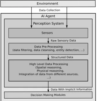
Perception is the ability of understanding the surrounding environment by receiv-ing and processreceiv-ing raw input data such as eye vision and sound. Henderson and Hollingworth [1999] divided human perception of a scene into three layers, where low-level perception concerns data collection and initial process; intermediate-level perception deals with data representation in terms of the entities’ geometric and spatial features; high-level perception cares about mapping meanings to the data representation. Chalmers et al. [1992] divided perception tasks into two levels, where low level perception refers to non-semantic data reception and process and high level perception starts when concepts of entities and their relations are considered. Perception tasks for AI agents aim to enable machine perception system to perceive the environment in a way that is similar to human and animal perception [Nevatia, 1982]. The techniques related to AI system’s perception cover many different fields of computer science and engineering. By analysing the functionalities of different components, we divide typical perception systems for AI agents into three layers (see Figure 1.2).
Sensors
Enviromnent
Data Pre-Processing
(data filtering, data cleansing, entity detection, ...)
High Level Data Processing (Spatial reasoning, Physical reasoning,
Integration of data from different sources, ...)
Perception System
Data Collection
Raw Sensory Data
Structured Data
Data With Implicit Information
Decision Making Modules
[image:22.595.112.445.240.584.2]AI Agent
§1.2 Spatial and Physical Reasoning in High Level Perception Systems 5
raw data. The data processing step may vary with different sensors and perception tasks. However, the general purpose of this layer is to extract useful information and abandon redundant components from the sensory data while considering the processing capability of sensors. For example, a set of laser sensors which aims to detect spatial features of a complex region may need to be able to communicate with each other at a low power cost which requires the ability of filtering and compressing data. Visual sensors (e.g. cameras and depth sensors) may be able to detect interesting objects from the entire scene and filter out background layers. This layer focuses on providing structured data instead of raw data for the third level to perform high level reasoning. The third layer takes results from the second layer as input to further reason about hidden information from the explicit knowledge. Thus, although the last two layers both deal with data processing, the output from the third layer concerns more about implicit information extraction rather than the existing data itself.
The proposed methods in this thesis is mainly related to the third layer which aims to improve the perceptional output by reasoning about relations among entities detected from raw sensory data. Undoubtedly, the first two layers determine if the perception result is valid for AI agents to produce reasonable outcomes, and the outputs from the first two layers demonstrate the perception system’s capability of interpreting the information of the surroundings of AI agents. However, the third layer decides to what extend the AI system is intelligent. Humans usually recognise concepts and relations between entities qualitatively. AI agents designed for many ap-plication areas require high level knowledge from this layer. For example, geographic information system (GIS) concerns high level spatial information of involved entities for several purposes including fast query processing, entity similarity assessment and visualization [Wolter and Wallgrün, 2012]; robotic manipulation requires accurate spatial and physical relations between objects. However, machine perception systems are far less advanced than human perception systems. Even intuitive perceptual capabilities for humans are difficult for machines. In the following section, research problems related to spatial and physical aspects in the third level will be discussed.
1
.
2
Spatial and Physical Reasoning in High Level Perception
Systems
In this section, we start with the discussion of research problems related to spatial reasoning followed by a discussion of physical aspect.
1.2.1 Perception Problems Related to Spatial Reasoning
knowledge representation and reasoning also plays an important role in machine perception. It is one of the essential components that makes GIS different from traditional map processing techniques [Berry, 1996]. Specifically, different aspects of spatial reasoning problems in GIS have been addressed, such as reasoning about directional information [Freksa, 1992; Frank, 1991, 1996], reasoning with topological information [Renz, 2002; Egenhofer, 1991; Cui et al., 1993; Egenhofer and Herring, 1990], reasoning about a combination of different kinds of spatial information [Frank, 1992; Zimmermann and Freksa, 1996; Zimmermann, 1993; Gerevini and Renz, 1998; Liu et al., 2009a].
In robotics, spatial reasoning is advocated to be an important capability of link-ing machine sensory data to human understandable spatial knowledge in order to accomplish human-robot interaction [Landsiedel et al., 2017]. Although high-accuracy sensors are available in recent years, the complex hardware is usually energy consum-ing and low in efficiency. Thus, reasonconsum-ing and integratconsum-ing relatively simple sensory data from different sources with low cost still remains as an important research topic in robotic perception [Smith et al., 2013]. For example, Moratz and Wallgrün [2003] discussed how spatial reasoning about topology, orientation and distance contributes to robot exploring in an indoor scene. In addition, qualitative spatial reasoning (QSR) approaches can adapt to uncertainty from incompleteness of sensory data, while pure quantitative models will fail due to insufficient input. Escrig and Toledo [1998] presented methods to solve different QSR tasks as constraint satisfaction problem which can be applied to robotics navigation.
Based on the discussion above, QSR mainly cares about representing properties of spatial entities and inferring their relations and potential changes. This charac-teristic allows us to reduce three dimensional (3D) entities into two dimensional regions by producing a projected map from a bird-eye view. For some problems that are not sensitive to manipulation but focusing on analysing overall trend of the input data, a bird-eye sensory input reduces unnecessary information but retains generally interesting parts. Although 3D spatial reasoning techniques have been studied recently [Albath et al., 2010; Cohen and Hegarty, 2012], these methods are usually with high complexity and will produce higher level of uncertainty. Therefore two dimensional (2D) spatial reasoning is still preferable as long as the projected dimension does not affect the reasoning tasks significantly.
§1.3 Methodology 7
data input which is usually not completely available in the real world scenario. With QSR methods, high flexibility of data requirement will provide the perception system an appropriate generality when quantitative methods with specific models does not work.
1.2.2 Perception Problems Related to Physical Reasoning
Reasoning about physical properties and relations is more complicated than reasoning about spatial information. Spatial information usually can be observed and repre-sented from the perceptive of different categories. Even in an unknown environment where sensory data is incomplete, missing parts can be inferred from the collected information following general routines. However, the methods for reasoning about physical properties and relations of entities vary from case to case. Thus, most phys-ical reasoning frameworks are designed to work in specific domains. In the past decades, qualitative physical reasoning have been extensively studied. In [Weld and de Kleer, 2013], most of the early work on qualitative physics has been discussed. Methods for modelling of naive physical processes and their causalities are covered in great detail. In this thesis, we focus on modelling a specific physical property of the objects, which is the supporting relation between connected objects in a structure. The discussion about research problems related to spatial reasoning in section 1.2.1 emphasises analytical capabilities of perception systems on sensory data rather than actually interacting with the world physically. Different from spatial reasoning tasks, the bird-eye view will lead to a considerable information loss when the entities’ physi-cal properties and relations are taking into account, as gravity which always points to the earth’s core implies the importance of the vertical dimension. The first problems we would like to address is to validate a method that is able to model the supporting relation between objects and the overall stability of the structure in a simplified 2D environment with limited prior knowledge about physical properties of the objects. Then, we will generalise the 2D method to 3D environments. This will lead to more challenges. For example, the representation of 3D entities are more complicated than that of 2D models. Also, 3D physical relations bring larger magnitude of uncertainty. If the 2D supporting and stability reasoning method does not satisfy in 3D world, how could we improve or modify it to fit the 3D environment is worth exploring.
1
.
3
Methodology
The performance of AI agents highly depends on the capability of perception systems on mining implicit information from raw or preprocessed sensory data. From the perspective of high-level reasoning in perception systems, two topics are worth exploring:
• How to represent simple but massive sensory data?
humans are good at observing and summarising rules from their observations to link and combine knowledge from different sources. For example, people are able to generate a map with reasonable landmarks in their mind after viewing a region from different angles. This problem is seemingly straightforward for humans, as humans have rich prior knowledge and reasoning capabilities to build linkage between different entities. It is however extremely difficult for AI systems. Compared with humans, AI agents do not have as extensive knowledge base and as strong capability of inducing knowledge from existing knowledge base. In order for AI agents to improve performance on real world perception tasks, sophisticated representations of sensory data which benefit reasoning procedures would be seriously considered.
• How to extract sufficient information by reasoning on the data representation for AI agents with special purposes? The principle of human inspiration still remains unclear and yet to be applied on AI agents. But it is important for AI agents to discover potential relations between scattered pieces of sensory data from sophisticated knowledge representation on specific domains. With incomplete input sensory data, a high uncertainty would be introduced while reasoning about underlying information. In order to reduce the uncertainty, novel reasoning mechanisms would be necessarily proposed.
Generally, we follow a bottom-up approach for the whole research procedure. First, we observe some practical unsolved problems related to spatial and physical aspects of AI perception systems. Then, we identify general characteristics of each kind of problem and formalise the problems. After that, we formulate hypothesises on how the problems could be solved potentially. Finally, we develop sophisticated methods to solve the problems in a systematic way with reasonable evaluation in both simulation and realistic environments.
1
.
4
Contributions and Thesis Outline
In this thesis, some essential problems related to spatial and physical aspects in AI perception systems are identified. For the spatial aspect, three problems are addressed:
1. How to integrate raw sensory data from different sources to suitable represent spatial information with noise and conflicts
2. How to extract spatial properties and relations between entities from the repre-sentation
3. How to predict spatial changes of entities with a tracking of their previous states
§1.4 Contributions and Thesis Outline 9
Chapter2
Background and Related Work
An important difference between an AI agent and an autonomous system is that the AI agent has the ability to adapt to different situations and to make decisions based on the information it collected. Thus, perception of real world environment is essential for AI agents to analyse and interact with their surroundings. Many techniques will be involved in a perception system for AI agents. For the low level perception, different sensors are used to collect necessary information. A commonly used sensor type is a vision sensor for capturing visual data in the form of single frame or video stream. There are many other sensor types to be used in different AI systems. For example, GIS may require specific sensors such as laser sensor for region measurement and hygrothermograph for climatic condition monitoring. At a higher level, the collected data needs to be processed in a way that it can be used by the decision making modules. For example, raw visual input will be segmented and the entities will be labeled, so that the agent can have a basic idea about the environment. Properly representing sensory data and reasoning about the relations between the detected entities will help AI agents to further infer hidden information that can be potentially useful for other modules. For instance, spatial relations such as connectivity and relative direction are helpful for localization, and the supporting relation between entities is important for robotic manipulation.
Due to the noise and incompleteness of real world sensory data, quantitative representation of the data may be inaccurate and lead to incorrect decisions. Qualita-tive reasoning (QR) which aims to maintain valuable information while discarding unimportant part is needed for real world perception. In this chapter, related work on the proposed perception algorithms including qualitative spatial reasoning, qualitative physical reasoning, hybrid reasoning and scene understand will be discussed in turn.
2
.
1
Qualitative Physical Reasoning
Perceiving general physical knowledge in the real world for AI agents is challenging due to high level uncertainty produced by limited range of sensory data. Quali-tative reasoning has been demonstrated to be capable of dealing with incomplete input data [Davis, 2008]. From onwards 1970s, qualitative physical reasoning has become an active research area with significant fundamental work emerged. NEW-TON [de Kleer, 1977] which performs physical predictions of motions of objects in a controlled environment showed the capability of qualitative reasoning systems to
solve commonsense physical problems. Hayes [1979] proposed to construct a general large-scale formalism of commonsense physical knowledge about the world instead of modelling trial toy problems individually. ENVISION [de Kleer and Brown, 1984] takes components as the primitives of physical state changes. By introducing a set of interacting rules, the possible subsequent states of the component and the causal analysis will be provided. In contrast, Qualitative Process Theory (QP) [Forbus, 1984] considers the physical processes as the cause of the behaviours. Therefore detailed modelling of components is not required. Different from the behaviour primitives of ENVISION and QP, QSIM [Kuipers, 1986] applies pure mathematical equations as constraints but not physical modelling of the components, processes and etc. These three frameworks with different primitives of physical behaviours cover most parts of early qualitative physics research.
In addition, the existence of massive physical domains makes it implausible to have a universal framework to model all physical domains. Forbus [1986] attempted to identify a computational account of how humans learn new physical domain knowledge but it is yet to be implemented. On the other hand, modelling of some general physical domains are discussed in [Davis, 2008]. For example, kinetic theory and dynamic theory are two different methods for reasoning about motions of rigid body with different expressiveness. The dynamic theory of rigid body, with a richer expressiveness, is discussed in detail in [Davis, 2007] where a pure qualitative method is used to model the components and processes in a closed domain.
However, present potential applications of physical reasoning often require the capability of performing reasoning in a complex domain, therefore dealing with quantitative information together with qualitative information is required. Such hybrid reasoning approaches will be discussed in Section 2.3.
2
.
2
Qualitative Spatial Reasoning
§2.3 Hybrid Reasoning 13
introduces more strict constraints, therefore reducing ambiguity of the reasoning results. However, the complexity is usually higher than reasoning with a single spatial aspect, thus the calculi to be combined should be selected and analysed carefully. In Chapter 3, a combination of size and directional information is used as constraints to decide the matching of the same set of spatial regions from different sensory input.
In addition, with the development of sensory techniques, 3D spatial representation starts to draw attention recent years. Similar to 2D spatial reasoning, 3D topology as a fundamental aspect was first studied [Albath et al., 2010; Sabharwal and Leopold, 2014]. Mojtahedzadeh et al. [2013] proposed a relational scene representation with respect to contact relations between 3D blocks and applied this representation to analyse the support relation between cuboid-shaped objects. Li et al. [2009] demon-strated a 3D spatial calculus combining topological and directional constraints and introduced an uncertainty model for dealing with large ambiguity of the 3D rep-resentation. A common limitation of the above mentioned calculi is that gathering precise quantitative data for constructing qualitative relations is difficult. Imprecise and incomplete input data may lead to much higher ambiguity or even mistakes in the reasoning outcomes. As a result, conflicts which are hard to resolve will occur during reasoning procedures (e.g. composition). Instead of typical 3D spatial reasoning methods, a 2D reasoning method that can deal with 3D data with high incompleteness by projecting the 3D entity onto a 2D plane is discussed in Chapter 6. In addition, in [Asl and Davis, 2014], a pure qualitative 3D rotation calculus was proposed to model the motion of robot arms. In this application, the robot arm is fully modeled, thus there is no concern with quality of the qualitative constraints. However, as a trade-off, this calculus can only be used in a narrow domain and is difficult to be extended.
Apart from reasoning about static spatial properties, spatial change is also of great interest. Reasoning with spatial change can be regarded as reasoning with a combination of spatial and temporal information [Galton, 2000]. It is emphasized that the assumption of continuous change is essential for reasoning about qualitative spatial change [Forbus, 2011]. Therefore the closeness of relations should be constructed with care.
2
.
3
Hybrid Reasoning
By satisfying qualitative constraints, pure QR techniques can efficiently deal with imprecise and incomplete data. In the real world, however, the nature of certain types of quantitative information make them difficult to benefit from qualitative representations. For example, "877 km (545 mi) NE of Melbourne"1describes location of Sydney relative to Melbourne. “877 km" as a quantitative constraint accurately bound the entities in an exact range. In contrast, a qualitative abstraction (e.g. close, far) of such quantitative description does not provide sufficient magnitude of precision for reasoning purpose, whilst “NE" is accurate enough for describing directional relation in this case. A combination of both qualitative and quantitative calculus is intuitive and more appropriate for reasoning with such constraints. In order to apply of QR approaches to more realistic domains, hybrid reasoning which aims to integrate
qualitative and quantitative reasoning methods is attracting incremental attention2. In the early days of QR research, the method of reasoning with a combina-tion of qualitative and quantitative informacombina-tion has been applied in several frame-works (e.g. [Forbus, 1980; de Kleer, 1989]) as some quantitative properties of entities were believed to be of nonsense to translate to qualitative representation and it was argued that purely qualitative reasoning framework did not exist [Forbus et al., 1991]. Then in the last decades, most theoretical research on knowledge representation and reasoning has adopted purely qualitative approaches which extensively extended the modelling power of QR methods. As a result, there has been several successful pure QR systems being applied in relatively narrow domains. Although pure QR approaches usually provide correct results, the results sometimes do not satisfy the re-quirement of certain applications which need a higher accuracy or cannot guarantee a necessarily closed domain. Dutta [1991] proposed a tractable hybrid spatial reasoning model where the quantitative constraints are expressed with fuzzy logic. In addition, research from cognitive perspective suggests that there is likely to be a simulation-like schema in humans’ physical reasoning procedure [Craik, 1943] which indicates that combining simulation with QSR is worth an attempt. Johnston and Williams [2008] combined slick simulator and tableaux reasoning; nevertheless simulation plays an dominant role in the model. In a more recent work, Welschehold et al. [2016] proposed a model to learn manipulation actions from human demonstration by combining quantitative optimization and qualitative matching of motion trajectories of the hand and the object.
2
.
4
High Level Perception and Scene Understanding
High level perception systems that can infer implicit properties of entities and their relations is required by AI agents that are supposed to work in unknown environment. With the availability of affordable RGB-D cameras such as Kinect, machines are able to sense their surroundings with depth information which is similar to humans’ way of perceiving the world. Modelling scenes from RGB-D data attracts increasing attention nowadays. Random sample consensus (RANSAC) [Fischler and Bolles, 1981] is widely used for detecting 3d shapes from RGB-D images. Dense RGB-D scans of a scene can be reconstructed with a 3D version of simultaneous localization and mapping (SLAM) algorithm [Salas-Moreno et al., 2013] by matching key descrip-tors (such as SHOT [Tombari et al., 2010], SIFT [Lowe, 2002], SURF [Bay et al., 2008] and ORB [Rublee et al., 2012]) detected from adjacent scans. However, for sparse scans, SLAM algorithms will occasionally fail as less key descriptors could be found. In order to deal with the incompleteness of the sensory data, inferring the hidden parts of the scene is essential. Ge et al. [2016] adopts a pure qualitative 2D stability analysis method to detect unknown objects in the world of the video game “Angry Birds". Shao et al. [2014] proposed an algorithm to recover the occluded parts of a RGB-D image by assuming shapes and symmetry of the entities.
High level perception methods are based on the results of the above mentioned procedures and aims to provide knowledge about the scene from a higher level by reasoning about implicit relations between the detected entities. The support relation
§2.4 High Level Perception and Scene Understanding 15
A
B
C
[image:33.595.139.502.102.318.2]Ground
Figure 2.1: Example of Top Supporter. Both A and C support B.
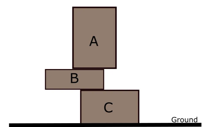
as one of the most important physical relations is studied from different perspectives. Silberman et al. [2012] proposed a framework for understanding indoor scenes from segmentation to support relation inference. With respect to support relation detection, first entities are labeled with different categories such as furniture and ground. Then a statistical model is trained to predict the likelihood of one object to be a supporter of the other object. This method is adopted and improved by [Zhuo et al., 2017; Panda et al., 2016] for more accurate support relation inference. These statistical methods are able to detect most obvious support relations that commonly appear in the real world. However, they can barely figure out some special but important support cases. For example, in Figure 2.1, the top object Aalso contributes to the stability of its underneath object B.
From a different perspective, there has been work on detecting support relations by reasoning about mechanical constraints. In [Gupta et al., 2010], objects in an outdoor scene are modeled with a volumetric representation. Taking the ground plane as the base, physical and geometric properties of objects are interpreted by validating a stable configuration of the objects. Mojtahedzadeh et al. [2013] qualitatively model the contact relation of cuboid-shaped objects and approximate contact points between them. Then, static equilibrium is used for a stability check. By explicitly assuming the shape of the objects, the contact points and the volume of the objects are approximated. As a result, this method cannot deal with complex shapes with an straightforward extension.
B
Ground
D
C
[image:34.595.87.450.93.254.2]A
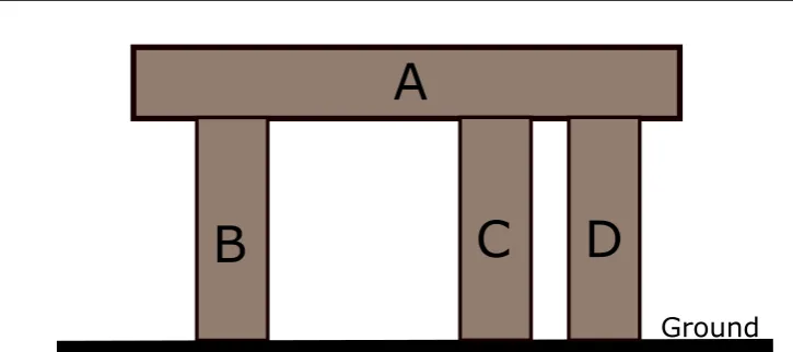
Figure 2.2: Example of Core Supporter. B is a core supporter of A, but neither C nor D is a core supporter of A.
Chapter3
Spatial Knowledge Representation
of Raw Sensory Data
The primary task for perception systems is to represent raw sensory input data in the form that potential interesting information is retained and abstracted. In this chapter, we present a method for extracting detailed spatial information from sensor measurements of regions. We analyse how different sparse sensor measurements can be integrated and what spatial information can be extracted from sensor mea-surements. Different from previous approaches to qualitative spatial reasoning, our method allows us to obtain detailed information about the internal structure of re-gions. The result has practical implications, for example, in disaster management scenarios, which include identifying the safe zones in bushfire and flood regions.
3
.
1
Introduction
There is the need for an intelligent system that integrates different information such as sensor measurements and other observations with expert knowledge and uses artificial intelligence to make the correct inferences or to give the correct warnings and recommendations. In order to make such an intelligent system work, we need to monitor areas of interest, integrate all the available knowledge about these areas, and infer their current state and how they will evolve. Depending on the application, such an area of interest (we call it a spatial region or just a region) could be a region of heavy rainfall, a flooded region, a region of extreme winds or extreme temperature, a region with an active bushfire, a contaminated region, or other regions of importance.
Considering such a region as a big blob or as a collection of pixels on a screen is not adequate, because these regions usually have a complex internal structure. A bushfire region for example, might consist of several areas with an active fire, several areas where the fire has passed already but are still hot, several areas that are safe, or several areas where there has been no fire yet, etc. These areas form the components of the bushfire region. Knowing such detailed internal structure of a region can help predict how the region evolves, as well as for determining countermeasures to actively influence how a region evolves.
In this chapter, we present methods for
• integrating measurements of spatial regions from different sensor networks to obtain more accurate information about the regions;
• extracting spatial information from the integrated sensor measurements in the form of a symbolic representation.
Having a symbolic representation of the internal structure instead of a collection of pixels on a screen allows us to answer queries, derive new knowledge, identify patterns, or to express conditions and rules, for example, when a warning must be issued. It also allows us to obtain an accurate approximation in the first place: by being able to represent the internal structure of a spatial region, we can build up a partial representation of the internal structure of a monitored region, track the region over time, and refine the partial representation whenever we obtain new sensor measurements or other new information.
The remainder of this chapter is organised as follows: in Section 3.2 we motivate and formally define the problem in question. This is followed by a review of related literature in Section 3.3. In Section 3.4 we describe the methods for matching sensor measurements and for extracting spatial information and evaluate them in Section 3.5. We conclude the chapter in Section 3.6.
3
.
2
Our Approach
The problem we are trying to solve, i.e. extracting accurate spatial information about theinternal structureof a region using sensor measurements, is a very general problem with many facets. It depends on (1) what assumptions we make about the regions, (2) what assumptions we make about the sensors, and (3) what kind of spatial information we are considering. We will make some restrictions on all three points to see if the desired outcome (i.e. accurate spatial information) can be achieved at all. In future work we plan to lift these restrictions and to allow greater generality. The restrictions and assumptions we make in this chapter are the following:
Regions: Acomplex region(cf. [Li, 2010])Ris a two-dimensional spatial entity in the
plane that can have a finite number ofcomponents. Each component can have arbitrary shape, extent and location and can have a finite number ofholes of arbitrary shape, extent and location. Each hole can recursively contain a complex region which is part of the original complex region. We say that each component, independent of whether it is inside a hole or not, is apositive componentof R, while each hole and each bounded or unbounded area of the plane that is not a positive component is a
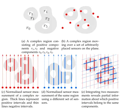
negative componentof R. See Figure 3.1a for an example of such a region.
Restrictions on regions: We assume that a given complex region is rigid, i.e. does not change shape, extent or relative location of any of its components. We allow regions to move, to change speed, direction of movement and their orientation. We further assume that during a sensor measurement, regions have constant speed, direction and orientation.
Sensors: A sensor sis a point in the plane that can measure whether it is inside a
§3.2 Our Approach 19
(a) A complex region con-sisting of positive compo-nents r1,r2 and negative
componentsr0,r3,r4,r5.
(b) A complex region mov-ing over a set of arbitrarily placed sensors on the plane.
(c) Normalised sensor mea-surement of a complex re-gion. Thick lines represent positive intervals and thin lines negative intervals.
(d) Normalised sensor mea-surement of the same region using a different set of sen-sors.
[image:37.595.119.520.101.458.2](e) Integrating two measure-ments reveals partial infor-mation about which positive intervals belong to the same components.
Figure 3.1: A complex region measured by two sets of sensors.
Restrictions on sensors: We assume that sensors are static and do not change their locations. Sensor plane and region plane can be different, but must be parallel.
Sensor measurements: A single sensor measurement (in short: a measurement) M
occurs when a complex region R moves over a set {s1, . . . ,sn} of sensors. Given the above assumptions and restrictions on regions and sensors, each measurement
M corresponds to a set {`1, . . . ,`n} of parallel directed lines, where each line `i corresponds to one sensorsi. The lines (more precisely line segments) start at the beginning of the measurement M and end at the end of the measurement. Each line may contain zero or more alternatingpositiveandnegative intervals, where each positive interval corresponds to the time when the sensor was in a positive component of Rand each negative interval corresponds to when the sensor was outside ofR(see Figure 3.1c). We assume that each measurement covers all positive components of the region. Note that the ordering of the parallel lines and the distances between lines depend on the direction of movement of the measured region and the actual location of the sensors on the plane relative to this direction.
distance between sensors. Any measurement can be converted to its corresponding normalised measurement Mif the direction of movement of the measured region and the actual sensor locations are known. This can be achieved by the following steps: (1) select a line orthogonal to the direction of movement such that all sensors are on the side of the line where the region is coming from, (2) project all sensors orthogonally on this line, and (3) subtract the distance between the line and each sensorsi at the beginning of each`i.
Restrictions on sensor measurements: We assume that the direction of movement of regions is known, which can be easily obtained if there is at least one sensor consisting of multiple pixels. Then we can always obtain a normalised measurement. Note that this is independent of the orientation of a region, i.e. how it is rotated, which is unknown. We further assume that different measurements of the same region are in-dependent, in particular that distances between sensors of a normalised measurement vary. This could result from different sets of sensors or from a different direction of movement.
Consequences of our assumptions and restrictions: Our assumptions are relatively
general, the strongest restriction we make is that complex regions are rigid. Except for direction of movement and location of sensors, everything else is unknown and unrestricted. Given two independent normalised measurements, these measurements correspond to two sets of parallel lines that cut through the measured region at independent and unknown angles δ (due to unknown orientation of regions). De-pending on the speed during a measurement, regions appear stretched/skewed along the direction of movement. The slower the movement, the more stretched is the appearance of the region as each sensor stays within the region longer. In addition, due to the unknown distance between sensor plane and region plane, the relative scale of each measurement is also unknown. In the example of a direct sunlight sensor, regions closer to the sensors appear larger in the measurement. Note that under our assumptions, it is interchangeable to have moving regions and static sensors, or moving sensors and static regions.
Spatial information: The spatial information we are considering is the topology of R
(for a complex region this refers to the number of components and holes and their hierarchy; cf. [Li, 2010]), the relative size of the components ofR, the relative direction and the relative distance between components ofR.
Problem description and motivation: In the following, we take as input two different
measurements Mand M0 as sets of parallel lines obtained in the way described above. The distance between the parallel lines is arbitrary and it does not matter which sensor corresponds to which line. That means that the only input we have available are the parallel lines and their intervals, we do not know what is happening between these lines. In order to obtain accurate spatial information about R we need to be able to infer this missing information. This will be achieved by integrating the different measurements through reconstructing the actual relationship between the measurements and the region.
Our approach is motivated by the following observations:
§3.3 Related Work 21
positive component of R. Without knowledge about the area between the two adjacent lines, we cannot say for sure whetheri1andi2refer to the same positive
component ofRor to two different ones (see Figure 3.1c).
2. Given a second measurementM0 that measuredRusing a different angleδ0 (see Figure 3.1d). Assume there is a positive interval i3 in M0 that intersects both
i1andi2, then we know for sure thati1 andi2 and alsoi3 are part of the same
positive component ofR(see Figure 3.1e).
It is clear that by integrating two or more measurements we obtain much more accurate information about a region than having one measurement alone. However, obtaining this information is not straightforward as the angle and the scale of the measurement is unknown. This results from our assumption that distance between region and sensors and orientation of the measured region are unknown. Therefore, our first task is to develop a method to identify a translation, rotation, and scaling that allows us to convert one measurement into another such that the intervals can be matched. Once we have obtained a good match, we will then extract detailed spatial information from the integrated sensor information. We then evaluate our method and determine how close the resulting spatial information is to the ground truth and how the quality depends on factors such as sensor density.
3
.
3
Related Work
Although the setting of our problem seems related to classical sensor fusion tech-niques [Crowley, 1993; LaValle, 2010], no such techtech-niques are known to be adequate to tackle our problem. For example, a sensor fusion method such as the extended Kalman filter requires a state transition model with specific parameters for each individual region and measurements of system inputs for its implementation, which is in practice difficult to obtain. Our approach is generic and does not have any of these requirements. In particular, it does not require a description of region geometry in terms of equations.
In the context of qualitative spatial reasoning [Cohn and Renz, 2008], most research has taken the objects (e.g. regions or relations) of a symbolic reasoning process as
givenand paid only little attention to the problem of acquiring such information from the environment. In [Santos and Shanahan, 2003] a stereo vision sensor measures 2D depth profile of a 3D environment taken at a particular height. The objects in the environment are represented as peaks of the depth profile graph. The depth peaks from different snapshots are then matched to provide a qualitative interpretation of their transitions. Inglada and Michel [2009] use remote sensing to extract topological relations between complex objects. A graphical representation of the relations is built to allow recognising objects using graph-matching techniques. Both mentioned methods, however, are not suitable for capturing detailed internal structures of regions that result from environmental parameters, such as light, sound, chemicals, temperature, pressure or magnetism. Our work makes no assumptions about the sensor type and includes sensor networks based on microelectromechanical system (MEMS) [Gardner et al., 2005] sensors that overcome such deficiencies.
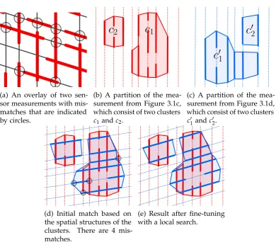
(a) An overlay of two sen-sor measurements with mis-matches that are indicated by circles.
(b) A partition of the mea-surement from Figure 3.1c, which consist of two clusters c1andc2.
(c) A partition of the mea-surement from Figure 3.1d, which consist of two clusters c10 andc02.
(d) Initial match based on the spatial structures of the clusters. There are 4 mis-matches.
[image:40.595.83.474.103.449.2](e) Result after fine-tuning with a local search.
Figure 3.2: Integration of sensor measurements based on Algorithm 1.
model for tracking topological changes in spatial regions monitored by a sensor network. Jiang and Worboys [2009] go further and provide a systematic formal classification of the possible changes to a region, based on point-set topology and graph homomorphism. All these algorithms, however, assume the regions to be constructed from connected subgraphs of adjacent sensor nodes that detect the region, which do not allow us to reason about the internal structure of the areas between the sensors measurements. By contrast, this chapter considers all aspects of the internal structure of regions and uses it to infer knowledge about the areas between sensor measurements.
Finally, there are interpolation techniques from computer vision [Szeliski, 2010] and spatial statistics [Cressie, 2011], which are not suitable for situations where the sensor network is sparse and only partial information about regions without further statistical information is known.
3
.
4
Closing the Gap in Sensor Measurements
§3.4 Closing the Gap in Sensor Measurements 23
spatial information about the complex region (Section 3.4.2).
3.4.1 Integration of Sensor Measurements
For integrating two independent measurements we search for parameter values for translation τ, rotation ρ and scaling σ of the second measurement that minimise mismatches with the first measurement. A mismatch occurs if, in the overlay of the sensor measurements, a positive interval from one measurement intersects with a negative interval from another measurement (see Figure 6.2). An uninformed local search in the parameter space will likely lead to local minima. In order to avoid such local minima, we first build clusters in the individual measurements that give us information about spatial structures of the measurements (Figure 3.2b and Figure 3.2c), and exploit this information to obtain a good initial match (Figure 3.2d). Once good initial values for τ,ρ,σ are found, we fine-tune and improve the match by using a local search method that further reduces the number of mismatches between the measurements (Figure 3.2e).
The details of our procedure are given in Algorithm 1. The main function is IntegrateSensorMeasurements, which takes two sensor measurements and first
determines for each sensor measurement a set of possible partitions (lines 2–3) by calling GenPartitions. A partition Pof a measurement Mconsists of clusters, where
a cluster is again comprised of positive intervals inM that potentially belong to the same positive component of underlying regionR(see Figure 3.2b and Figure 3.2c). To be precise, we say two positive intervalsi1 andi2 are neighboured and writei1 ∼i2, if
i1andi2are from adjacent sensor lines and temporally overlap. We furthermore say
that positive intervalsi1and i2 belong to the same cluster (or to the same equivalence
class), ifi1∼+i2, where∼+is the transitive closure of∼. This allows us to obtain a
partition (or quotient set)M/∼+of the sensor measurementM.
Since some of these clusters could actually belong to the same component of R
(unless there exists a negative interval in M that clearly separates the clusters), we consider all coarser partitions of M/∼+ induced by combining clusters that could
potentially belong to the same connected component ofR. This is done by calling Function GenCoarserPartitions (line 16), where two clusters are merged if the
distance between the clusters is less than a threshold value. This value controls the number of possible coarser partitions which is at most 2|M/∼+|. Note that it is irrelevant if the detected clusters reflect the positive components of R truthfully, as they are only used to find a good initial match and not for obtaining spatial information.
From collections L,L0 of all coarser partitions of measurements M,M0 that we obtained in the previous step, we now try to find a pair of partitions fromL×L0 that will lead to the best match of M,M0. As a heuristic for finding such a pair we rank all pairs(P,P0)∈L×L0 according to the structural similarity betweenPandP0by means of Function StructDist(line 4). More precisely, Function StructDistmeasures the
Algorithm 1:Integrating sensor measurements.
1 Function IntegrateSensorMeasurements(M, M’)
Input :Two different measurementsM andM0.
Output :The merged version ofM andM0.
// initial match
2 L←GenPartitions(M)
3 L0 ←GenPartitions(M0)
4 S←Rank(L×L0, key=StructDist)
5 v∗ ←∞, τ∗ ←0, ρ∗ ←0, σ∗←0
6 whilev∗> eand S6=∅do
7 (P,P0)←Pop(S)
8 (v,τ,ρ,σ)←GetParameter(P,P0)
9 ifv< v∗ then
10 (v∗,τ∗,ρ∗,σ∗)←(v,τ,ρ,σ)
// local search
11 (τ∗,ρ∗,σ∗)←MinMismatches(M,M0,τ∗,ρ∗,σ∗)
12 return M∪Rotate
ρ∗(Translateτ∗(Scaleσ∗(M0)))
13 Function GenPartitions(M)
Input :A sensor measurements M.
Output :A list Lof partitions of M.
14 foreach positive intervals i1,i2 ∈ Mdo
15 Seti1 ∼i2, ifi1andi2are from adjacent sensors and temporally overlap. 16 L←GenCoarserPartitions(M/∼+)
17 return L
18 Function StructDist(P,P0)
Input :Two setsP,P0 consisting of clusters.
Output :The structural distance betweenPandP0.
19 (c1,c2, . . . ,ck)←SortSize(P) 20 (c10,c02, . . . ,ck00)←SortSize(P0) 21 return∑max{k,k
0}−2
i=1 |∠cici+1ci+2−∠c0ic0i+1c0i+2| ·wi
similarity betweenPandP0. This is achieved by the following formula:
max{k,k0}−2
∑
i=1|∠cici+1ci+2−∠ci0ci0+1c0i+2| ·wi, (3.1)
§3.4 Closing the Gap in Sensor Measurements 25
Algorithm 2:Extracting spatial knowlege.
1 Function ExtractSpatialKnowledge(M)
Input :Sensor measurement M.
Output :An augmented containment tree ofM.
2 C←GetConnectedComponents(M)
3 T←ContainmentTree(C)
4 T+←Augment(T)
5 returnT+
6 Function GetConnectedComponents(M)
Input :Sensor measurement M
Output :List of connected pos. and neg. components
7 foreach positive intervals i1,i2 ∈ Mdo 8 Set i1 ∼i2, ifi1intersects i2.
9 foreach negative intervals i1,i2∈ M do
10 Set i1 ∼i2, ifi1intersects i2.
11 return M/∼+
After ranking the pairs of partitions according to the similarity criteria in formula (3.1), we start with the pair with the highest similarity from the ranked list S, and calculate initial parameter values τ,ρ,σ respectively for translation, rotation and scaling. To overcome local minima we choose the pair of partitions with the next highest similarity fromSuntil either the numbervof mismatches are below a threshold e or no more pairs of partitions are left inS (lines 6–10). Obtaining the number v of mismatches and the parameter values from a pair of partitions is achieved by calling function GetParameter(line 8), which compares the two most salient and
clearly distinguishable clusters(c1,c2)and (c10,c02)from the partitions and determines
the translation, rotation and scale between those pairs. After obtaining the initial parameters, function MinMismatches further reduces the number of mismatches
and fine-tunes the result by performing a local search around the initial parameter values (line 11). This is done by means of point set registration, which is a local search technique for matching 2D point sets [Jian and Vemuri, 2011]. As point set registration requires two sets of points as its input, we uniformly sample points from positive sensor intervals of both of the sensor measurements. The final outcome is the union of two sensor measurements, where the second sensor measurement is transformed using the parameters found.
3.4.2 Spatial Knowledge Extraction