Article
A New Landscape Classification Approach for
Quantifying Spatial Pattern of Bac Kan Province,
Vietnam
Trong Dai Ly
1,2,aand Suwit Ongsomwang
1,b,*1 School of Geoinformatics, Institute of Science, Suranaree University of Technology, Nakhon Ratchasima,
Thailand
2 Institute of Geography, Vietnam Academy of Science and Technology, 18 Hoang Quoc Viet, Hanoi,
Vietnam
E-mail: a[email protected], b[email protected] (Corresponding author)
Abstract. Landscape theory and its application have played an important role in natural
resource exploitation and environmental protection. Various classification approaches had been employed worldwide in landscape ecology studies. This paper had developed a new hierarchical landscape classification framework for quantifying spatial pattern of Bac Kan province. A landscape formation equation was applied with three natural factors (geology, topography, and soil) and cultural factor (land use). A multi-level segmentation technique with multiresolution segmentation algorithm was chosen to segment landscape units (patches) and to categorize landscape types at different levels. The results revealed that the landscape classification of Bac Kan province has 4 hierarchical levels. Level 4, which provided full details of spatial pattern based on geologic period, elevation, soil depth, and land use, had 315 landscape types. At this level, there are 8,427 landscape units mapped with a minimum and maximum areas of 0.02 km2 and 116.63 km2, respectively. A new Bac Kan
landscape map at a scale of 1:100,000 along with 16 different attributes for each landscape unit was also produced. In conclusion, the framework of research methodology presented in this paper can be used as a guideline for landscape classification at provincial and national levels.
Keywords: Landscape classification, landscape type, landscape ecology, multi-level
segmentation, Bac Kan Province, Vietnam.
ENGINEERING JOURNAL Volume 23 Issue 6
1.
Introduction
Currently, the new landscape classification approaches, which relate to landscape ecology and landscape pattern analysis, have played an important role in solving integrated problems related to natural resources exploitation and environmental protection. Since, landscape ecology considers a territory space as a system that consists of both natural elements, namely geology, topography, soil, climate, and vegetation as well as human components, such as residential and land use patterns. Under these approaches, each territory is clarified through analyzing its structure, function, and dynamics as the main characteristics of landscape ecology. These are an essential, solid and reliable scientific basis for sustainable development planning. Thus, identifying landscape unit and establishing landscape type with diagnostic criteria usually become the first essential step in several studies. This crucial step was mentioned and conducted at continental level for different European landscape maps [1-4]. Besides delineating landscape units, studying landscape pattern analysis was successfully conducted in different countries such as Kim and Pauleit [5], Swanwick [6], Ongsomwang and Ruamkaew [7], Ongsomwang and Sutthivanich [8], Tudor [9], Ongsomwang [10], Van Eetvelde and Antrop [11], Bosun et al. [12], Käyhkö et al. [13], Blasi et al. [14], Brabyn [15], Otahel [16], Lioubimtseva and Defourny [17], Nogué et al. [18], Perko et al. [19], Romportl et al. [20], Divíšek et al. [21]. In Vietnam, studies of landscape classification are mainly based on the theoretical backgrounds of Soviet scientists by using natural geographic zoning. Among those studies, the multi-level landscape classification system of Lap [22], which is the first landscape classification system in Vietnam, was applied to classify landscape in Northern Vietnam. Since then, landscape ecology scientists and researchers have applied his theoretical concept for their different studies to meet practical requirements. Most of those studies were conducted at regional and national levels with small scales, such as landscape map of Southern Vietnam [23], landscape map of Vietnam at the scale of 1:1,000,000 [24, 25]. Nevertheless, these studies provide information on the structure, locations and other properties of landscapes of Vietnam but most of them were manually produced. Therefore, a new landscape classification approach is required to examine for Vietnam territory, particularly areas with highly landscape diversities. Hence, Bac Kan province which represents such area is chosen as the study area.
Generally, there are many variants of the definition of landscape. As a result, understanding and applying it depends on the research and management context. Mücher et al. [4] stated that landscape is considered to form recognizable parts of the Earth's surface, it shows a characteristic ordering of elements, although it is often heterogeneous. Every landscape is also considered as a system of elements connected to each other by energy, matter or information [26]. This complex system is formed and maintained by the mutual action of abiotic and biotic forces as well as human action [27]. However, this system by itself shows different functions which refer to the broad categories of “services” that consists of production, protection, and regulation [28]. Landscapes are entities where many components and processes interact [4]. It was agreed that landscape is a function of abiotic, biotic and cultural factors as shown in Eq. (1) [4, 29, 30].
Landscape=Abiotic components+Biotic components+Cultural components (1)
Abiotic components of a landscape are non-living chemical and physical parts of the environment that affect living organisms and the function of the ecosystem, e.g. geology and soil [31]. On the contrary, biotic components include everything that is living, e.g. animals and plants. Lastly, cultural components of a landscape include anything that was human-made or influenced, e.g. fences and dams [32].
Lipský and Romportl [29] suggested that when characterizing a complex landscape typology based on the synthesis of both natural and cultural features, the use of hierarchical dependency is recommended (Fig. 1). However, cultural features are too complex to categorize in a simple, comprehensive and internationally accepted way. Thus, how to interpret and classify cultural data have not yet achieved sufficient international consensus and digital data sets of cultural features are rare [4]. Therefore, physico-geographical method which is based on natural features (geology, soils, geomorphology, climate, and potential vegetation) without human activities is the most common for landscape classification and mapping of natural landscapes.
In this study, by considering all the natural (abiotic and biotic) and cultural factors, the equation for landscape formation of Bac Kan province is proposed as shown in Eq. (2).
where C is climate, G is geology, T is topography, S is soil, LU is land use, and t is time.
Based on landscape formation equation, climate, geology, topography, and soil is considered as natural factors while land use is here considered as a cultural factor which represents human activity pattern. However, the climate of Bac Kan province only belongs to subtropical-dry winter type (Cwa) which is monsoonal influenced, having the classic dry winter pattern associated with tropical monsoonal climates [33], so this factor will not be applied for landscape classification. Consequently, Bac Kan landscape classification and mapping will be implemented based on geology, topography, soil, and land use factors.
The specific objective of this research is to establish a framework for classifying landscape types in order to produce a landscape map and its database using high spatial accuracy data. The derived landscape classification map can provide important information for quantifying spatial pattern and also builds a bridge for communication among scientists, researchers, and decision-makers.
Fig. 1. Landscape type as a functional hierarchy of abiotic, biotic and cultural elements [29, 30].
2.
Study Area
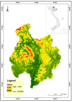
The study area is Bac Kan province situates in northeastern Vietnam. It is bounded by geographic coordinates between 21 48' N to 22 44' N and 105 26' E to 106 15' E (Fig. 2) and covers an area of 4,861.18 km2.
According to the Statistical Yearbook of Vietnam in 2017, the province had a population of 323,000 people [34].
[image:3.595.117.480.230.437.2]Fig. 2. Study area.
3.
Research Methodology
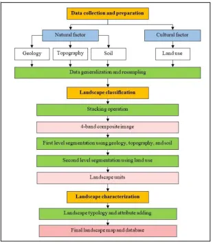
The framework of research methodology on landscape classification and characterization consists of three major components: data collection and preparation, landscape classification, and landscape characterization (Fig. 3).
3.1 Data Collection and Preparation
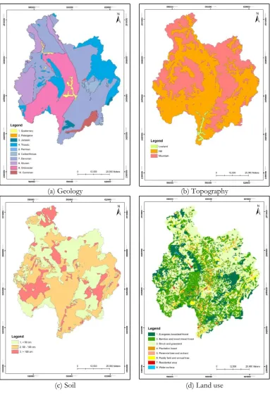
The basic information of the collected data for landscape classification is provided in Table 1. Under this component, all relevant data sources covering the whole study area were collected, then the most proper data sets were critically reviewed for obtainability, which led the selection of geology, topography, soil, and land use for identifying and delineating landscape units. Simensen et al. [37] stated that these four diagnostic criteria were most frequently used to classify landscape units. The geologic period, which was obtained from geology map, was here used to represent the continuous process of forming landscape. In fact, different period affects to parent material formation and organism development which are the key factors influencing landscape. Similarly, elevation data, which was obtained from topography map was applied to classify landform of landscape. In the meantime, soil depth, which is very crucial factor for plant growth, was extracted from soil map. Likewise, land use, which represents human activities on landscape, was extracted from land use map.
[image:4.595.171.426.78.435.2]four thematic data layers: geology with 10 classes, topography with 3 classes, soil with 3 classes, and land use with 8 classes, were achieved (Fig. 4).
Fig. 3. A framework of research methodology.
3.2 Landscape Classification
Multi-level segmentation technique [38, 39] which was successfully applied in European landscape classification [4] was used to identify landscape units. Segmentation (object recognition based on spatial characteristics) is the process of identifying spatial units, which are mostly derived from satellite imagery, which was implemented using the eCognition software, which is object-oriented image segmentation and classification software for multi-scale analysis [40].
In practice, four thematic data layers were firstly combined using stacking operation under ERDAS Imagine software to produce a 4-band composite image before image segmentation, then a multiresolution segmentation algorithm under the eCognition software was chosen to segment image objects (patches) at two different levels. This algorithm is an optimum procedure for minimizing the average heterogeneity and maximizing the respective homogeneity by merging pixels into image objects [40].
At the first level of image segmentation, only three thematic layers: geology, topography, and soil were applied to segment image objects with optimum parameter setting by trial and error. At this level, scale parameter was set to 30, shape factor was set to 0, and compactness was set to 0.5. The result of image objects from this level was considered to be a fixed matrix since all input data (geology, topography, and soil) represents abiotic component of the natural factor on the landscape.
[image:5.595.143.454.115.471.2]final image segmentation for identifying the landscape units based on combination geology, topography, soil, and land use. After that, the result was exported from the eCognition software to a shapefile of ESRI ArcGIS software for data post-processing. Herein, polygons that are smaller than 0.02 km2 were merged with the
adjacent polygon to produce final landscape units according to the minimum mapping unit [41].
3.3 Landscape Characterization
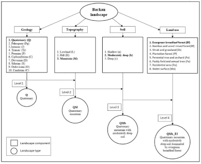
The derived landscape units of Bac Kan were described based on landscape typology which is a hierarchical naming process for every landscape type at four levels by a combination of geology, topography, soil and land use. The first level is geology, followed by the second level with a combination of geology and topography. At the third level, every unit is a combination of geology, topography, and soil and the fourth level, which is the most detail of the classification, is made of all criteria, geology, topography, soil, and land use. Finally, a database was built by adding 16 different attributes to each spatial landscape unit that stored as a record. These spatial landscape units and their attributes as a GIS database can be used as efficient dataset to characterize landscape as a functional hierarchy of natural and cultural phenomena of Bac Kan province. Figure 5 illustrates hierarchical landscape typology with four levels, e.g. “QMb_Ef” represents a combination of Quaternary Mountain with moderate soil depth dominated by Evergreen broadleaf forest.
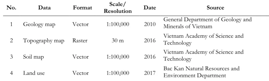
Table 1. Basic information of input data for landscape classification.
No. Data Format Resolution Scale/ Date Source
1 Geology map Vector 1:100,000 2010 General Department of Geology and Minerals of Vietnam
2 Topography map Raster 30 m 2016 Vietnam Academy of Science and Technology
3 Soil map Vector 1:100,000 2016 Vietnam Academy of Science and Technology
4 Land use Vector 1:100,000 2017 Bac Kan Natural Resources and Environment Department
Table 2. Basic information after data generalization.
Geology Topography Soil Land use
No. Geologic period Code No. Elevation (m) Typology Code No. Soil Depth (cm) Typology Code No. Typology Code
1 Quaternary Q 1 0 - 100 Lowland L 1 <50 Shallow a 1 Evergreen broadleaf forest Ef
2 Paleogene Pg 2 100 - 500 Hill H 2 50-100 Moderately deep b 2 Bamboo and wood mixed
forest Bf
3 Jurassic J 3 > 500 Mountain M 3 >100 Deep c 3 Shrub and grassland Sh
4 Triassic Tr 4 Plantation forest Pf
5 Permian P 5 Perennial tree and orchard Po
6 Carboniferous C 6 Paddy field and annual tree Pa
7 Devonian D 7 Residential area Ra
8 Silurian S 8 Water surface Wa
9 Ordovician O
[image:6.595.75.512.328.460.2](a) Geology (b) Topography
(c) Soil (d) Land use
[image:7.595.106.490.75.637.2]Fig. 5. Structure of 4-level hierarchical landscape typology.
4.
Results
4.1. Landscape Classification
The classification process of the Bac Kan landscape was implemented through multi-level segmentation technique which is a new approach to build the process on a priori selection of variables based on landscape theory within the applied scientific discipline [37]. In this study, a 4-band composite image (i.e. geology, topography, soil, and land use) was built to segment landscape units into two levels.
4.1.1. First level segmentation
[image:8.595.89.505.91.430.2](a) Entire study area
(b) Zoom-in area (red box in a)
Fig. 6. Result of segmentation at level 1 using 3 layers (geology, topography, and soil).
Table 3. Example of image object information of OB1 after segmentation at level 1.
No Feature Value
[image:9.595.198.397.77.327.2]4.1.2. Second level segmentation
After achieving image objects from Level 1, the segmentation process at Level 2 based on land use thematic layer was carried out. It is obviously observed that number of image objects dramatically increases at this level. The result shows that total 30,633 image objects before data post-processing were segmented for the whole study area (Fig. 7) because all image objects from segmentation at Level 1 were further segmented with 8 thematic land use classes. Therefore, a significant number of new image objects were created at this level, and a new attribute of land use was added for each image object. Table 4 shows an example of image object information of image object 2 (OB2). In this example, OB2 was defined by the feature of Shrub and grassland (Sh) from land use, other features were adopted from OB1 (Table 3).
(a) Entire study area
(b) Zoom-in area (red box in a)
[image:10.595.211.387.215.433.2]Table 4. Example of image object information of OB2 after segmentation at level 2
No Feature Value
1 Number of pixels 29,537 2 Thematic object attribute 1 (Code of geologic period) Tr (Triassic) 3 Thematic object attribute 2 (Code of topography) M (Mountain) 4 Thematic object attribute 3 (Code of soil depth) a (Shallow)
5 Thematic object attribute 4 (Code of land use) Sh (Shrub and grassland)
4.2. Landscape Characterization
After data post-processing, 8,427 landscape units with minimum and maximum areas of 0.02 km2 and 116.63
km2 were approved for landscape typology which was categorized into 4 levels: Level 1, 2, 3 and 4. Brief
information with highlight classes of each level is summarized below.
Level 1. Landscape classification at level 1 is based on the geologic period only, has 10 classes. The largest
class at this level is the area forming since Devonian (D) with 2,074.02 km2 and accounts for 42.66% of the
whole study area while the smallest class is Paleogene (Pg) with 0.63 km2 and makes up only 0.01%.
Level 2. Landscape classification at level 2 is based on geologic period and elevation and has only 23
classes from the total possibility of 30 classes (10 x 3 classes). The largest class in this level is Devonian Mountain (DM) with 1,038.32 km2 and the smallest class is Quaternary Mountain (QM) covering an area of
0.12 km2.
Level 3. Landscape classification at level 3 is depended on geologic period, elevation, and soil depth and
has 59 classes from the total possibility of 90 classes (10 x 3 x 3). The largest class is Ordovician Hill with moderately soil depth (OHb) with 521.50 km2 and the smallest class is Quaternary Mountain with shallow
soil depth (QMa) with 0.12 km2.
Level 4. Landscape classification at level 4 which is the last and highest level, based on all four layers
(geologic period, elevation, soil depth, and land use). Theoretically, with 10 geology classes, 3 topography classes, 3 soil classes, and 8 land use classes, 720 combinations (10 x 3 x 3 x 8 classes) are possible for landscape types characterization at this level but in fact only 315 combinations were found in the study area, and therefore final landscape map was produced with 315 landscape types. The largest landscape type is Ordovician hill with moderately soil depth and dominated by bamboo and wood mixed forest (OHb_Bf) and covers a total area of 261.56 km2 with 151 patches. The smallest landscape types which cover same area of
only 0.02 km2 are DLa_Wa, PHc_Bf, and QHb_Wa.
[image:11.595.78.512.104.188.2][image:12.595.77.520.78.693.2]
Table 5. Area and percentage of Bac Kan Landscape classification at level 2.
Level 1 Level 2
Class (10 classes) (kmArea 2) % Class (23 classes) (kmArea 2) %
Quaternary (Q) 59.34 1.22 Quaternary Hill (QH) 59.22 99.80 Quaternary Mountain (QM) 0.12 0.20 Paleogene (Pg) 0.63 0.01 Paleogene Mountain (PgM) 0.63 100.00
Jurassic (J) 51.86 1.07
Jurassic Lowland (JL) 0.83 1.60 Jurassic Hill (JH) 27.74 53.49 Jurassic Mountain (JM) 23.29 44.91 Triassic (Tr) 799.22 16.44 Triassic Hill (TrH) Triassic Mountain (TrM) 338.90 460.32 42.40 57.60
Permian (P) 4.34 0.09 Permian Hill (PH) 3.54 81.60 Permian Moutain (PM) 0.80 18.40 Carboniferous (C) 106.54 2.19 Carboniferous Hill (CH) 16.08 15.09 Carboniferous Mountain (CM) 90.46 84.91
Devonian (D) 2074.02 42.66
Devonian Lowland (DL) 32.14 1.55 Devonian Hill (DH) 1003.56 48.39 Devonian Mountain (DM) 1038.32 50.06 Silurian (S) 547.47 11.26 Silurian Hill (SH) 298.11 54.45 Silurian Mountain (SM) 249.36 45.55
Ordovician (O) 1114.34 22.92
Ordovician Lowland (OL) 9.98 0.90 Ordovician Hill (OH) 931.07 83.55 Ordovician Mountain (OM) 173.30 15.55
Cambrian (Ca) 103.41 2.13
Cambrian Lowland (CaL) 0.28 0.27 Cambrian Hill (CaH) 89.07 86.13 Cambrian Mountain (CaM) 14.06 13.60
Table 6. Structure of attribute of each landscape unit.
No Field Name Explanation
1 OBJECTID Identity of landscape unit 2 Area Area of landscape unit 3 GP_N Name of geologic period 4 GP_C Code of geologic period 5 Topo_T Typology of topography 6 Topo_C Code of topography 7 Topo_E Elevation value 8 Soil_T Typology of Soil depth 9 Soil_D Soil depth value 10 Soil_C Code of soil depth 11 Land_N Land use type 12 Land_C Land use code
[image:13.595.84.514.102.489.2] [image:13.595.78.513.523.738.2]5.
Validation: A Comparison with Existing Landscape Maps
At present, there are only two previous studies related to landscape classification in Bac Kan province. The oldest map is landscape classification of Vietnam at a scale of 1: 1,000,000 [25], and the other one is Bac Kan landscape classification at scale of 1: 100,000 [42]. These two maps were here used to compare for validation the result of a new Bac Kan landscape classification map.
5.1. Landscape Map of Vietnam
In regard to the landscape map of Vietnam [25], it is obviously shown that two different approaches made a struggle in comparing between this map and the new landscape map of Bac Kan. Since, the new landscape classification approach searches for general features distinguishing the landscape from the surroundings and maps landscape unit based on similar features, which can separately occur elsewhere. It consists of a systematization based on similarities and results in landscape typology [43]. Meanwhile, landscape classification approach of Hai et al. [25] is to highlight unique individual features of the landscapes for distinguishing the given landscape units from others; this way is used to determine and map unique, individual landscapes occurring in unique areas and nowhere else. This approach results in landscape regionalization [43]. As a result, Bac Kan province only belongs to a unique Bac Thai low mountain region based on climate conditions effect by monsoon regime. Besides, the landscape map of Vietnam was manually produced without high accurate data and computer support. Therefore, spatial data comparison between these two approaches is limited since digital map is unavailable at present. Nevertheless, there is a clear resemblance from the perspective of the key factor (climate) between landscape map of Vietnam and the new landscape map of Bac Kan province.
5.2. Existing Landscape Map of Bac Kan Province
Under the landscape classification approach of Giang et al. [42], topography, soil, and vegetation were manually superimposed to produce landscape units and then converted in digital format (digitization) (Fig. 9). However, the hierarchical structure of landscape classification is from attribute.
On the contrary, the new landscape classification approach used a multi-level segmentation technique under the eCognition software to classify image segments as landscape units. The new approach emphasizes the usefulness and convenience of objected-based oriented software, it not only helps to improve spatial accuracy but also reduces time and effort. Additionally, this approach can efficiently handle large data and create higher number of landscape units in detail. The new landscape map consists of 8,427 units while the existing landscape map of Bac Kan has only 1,377 units (Table 7).
Fig. 9. The landscape map of Bac Kan province [42].
Table 7. A comparison of spatial property and criteria between the new landscape classification approach and the existing landscape classification of Giang et al. [42].
Criteria Item New landscape classification Existing landscape classification Approach Technique Multi-level segmentation Manual superimpose and digitization
Spatial property
No. of landscape types 315 78
No. of landscape units 8,427 1,377
Minimum area of
landscape unit 0.02 0.44
Maximum area of
landscape unit 116.63 180.17
Mean area of
landscape unit 0.57 3.53
Criteria
Level 1 Geology (10 classes) Topography (5 classes) Level 2 Geology and topography (23 classes) Topography and soil (21 classes)
Level 3 Geology, topography and soil (59 classes) Topography, soil, and vegetation (78 classes)
[image:15.595.94.504.79.459.2] [image:15.595.73.522.533.751.2]6.
Conclusions
A new landscape classification approach based on landscape formation, which depends on natural and cultural factors, was successfully developed for quantifying spatial pattern of Bac Kan province. As a result, the new landscape map of Bac Kan was systematically classified into 4 levels with 315 landscape types based on geological formation, elevation, soil depth and land use using a multi-level segmentation technique. Additionally, a spatial dataset with 16 attributes can be easily used to automatically produce landscape map at various levels. These outputs can be further used as input for landscape pattern analysis. Although, this study is limited to biophysical and cultural factors since there is lack of data on socio-economic aspects. If this data is available, it will be useful for improving and extending attribute of the future landscape classification.
Nevertheless, the framework of the methodology presented in this paper can be used as guideline for landscape classification at provincial level. Moreover, the new landscape classification approach can be promoted to be applied at the national level for different ASEAN countries.
References
[1] E. V. Milanova and A. V. Kushlin, World Map of Present-Day Landscapes: An Explanatory Note. Moscow: Department of World Physical Geography and Geoecology, Moscow State University, 1993.
[2] J. Meeus, “Pan-European landscapes,” Landscape and Urban Planning, vol. 31, no. 1-3, pp. 57-79, 1995. [3] C. O. Europe, “European landscape convention,” in Report and Convention. 2000.
[4] C. Mücher, J. Klijn, D. Wascher, and J. Schaminée, “A new European Landscape Classification (LANMAP): A transparent, flexible and user-oriented methodology to distinguish landscapes,” Ecological indicators, vol. 10, no. 1, pp. 87-103, 2010.
[5] K. H. Kim and S. Pauleit, “Landscape character, biodiversity and land use planning: The case of Kwangju City Region, South Korea,” Land Use Policy, vol. 24, no. 1, pp. 264-274, 2007.
[6] C. Swanwick, Landscape Character Assessment. Guidance for England and Scotland. 2002.
[7] S. Ongsomwang and S. Ruamkaew, “Agricultural and forestry landscape sustainability evaluation using sustainability indicator, Lamtakhong watershed, Nakhon Ratchasima, Thailand,” Suranaree Journal of Science and Technology, vol. 20, no. 2, pp. 167-182, 2013.
[8] S. Ongsomwang and I. Sutthivanich, “Integration of remotely sensed data and forest landscape pattern analysis in Sakaerat Biosphere Reserve,” Suranaree Journal of Science and Technology, vol. 21, no. 3, pp. 233-248, 2014.
[9] C. Tudor, An Approach to Landscape Character Assessment. Natural England, 2014.
[10] S. Ongsomwang, “Forest assessment and landscape ecology study in Thailand,” Suranaree Journal of Science and Technology, vol. 22, no. 1, pp. 61-82, 2015.
[11] V. Van Eetvelde and M. Antrop, “A stepwise multi-scaled landscape typology and characterisation for trans-regional integration, applied on the federal state of Belgium,” Landscape and Urban Planning, vol. 91, no. 3, pp. 160-170, 2009/06/30/ 2009.
[12] W. Bosun, P. Shaolin, G. Luo, and Y. Youhua, “Diversity of tropical forest landscape types in Hainan Island, China,” Acta Ecologica Sinica, vol. 27, no. 5, pp. 1690-1695, 2007.
[13] N. Käyhkö, O. Granö, and M. Häyrynen, “Finnish landscape studies–a mixture of traditions and recent trends in the analysis of nature-human interactions,” Belgeo. Revue belge de géographie, no. 2-3, pp. 245-256, 2004.
[14] C. Blasi, G. Capotorti, R. Copiz, D. Guida, B. Mollo, D. Smiraglia, and L. Zavattero, “Classification and mapping of the ecoregions of Italy,” Plant Biosystems-An International Journal Dealing with all Aspects of Plant Biology, vol. 148, no. 6, pp. 1255-1345, 2014.
[15] L. Brabyn, “Classifying landscape character,” Landscape Research, vol. 34, no. 3, pp. 299-321, 2009. [16] J. Otahel, “Landscape and landscape research in Slovakia,” Belgeo. Revue belge de géographie, no. 2-3, pp.
337-346, 2004.
[17] E. Lioubimtseva and P. Defourny, “GIS-based landscape classification and mapping of European Russia,” Landscape and Urban Planning, vol. 44, no. 2-3, pp. 63-75, 1999.
[18] J. Nogué, Pere, and J. Grau, The Landscape Catalogues of Catalonia: Methodology. Landscape Observatory of Catalonia, 2016.
[20] D. Romportl, T. Chuman, and Z. Lipsky, “Landscape typology of Czechia,” Geografie, vol. 118, no. 1, pp. 16-39, 2013.
[21] J. Divíšek, M. Chytrý, V. Grulich, and L. Poláková, “Landscape classification of the Czech Republic based on the distribution of natural habitats,” Preslia, vol. 86, pp. 209-231, 2014.
[22] V. T. Lap, Geographical Landscape of Northern Vietnam. Science and Technics Publishing House, 1976. [23] T. Q. Hai, “Landscape typology of Southern Vietnam, Problems of Geography,” Bulgarian Academy of
Sciences, no. 2, pp. 65-70, 1991.
[24] N. N. Khanh, N. C. Huan, and P. H. Hai, “A study of Vietnamese landscape classification at a scale of 1: 1000 000 (land and sea),” VNU Journal of Science: Earth and Environmental Sciences, pp. 15-22, 1996. [25] P. H. Hai, N. T. Hung, and N. N. Khanh, Landscape Basis of Reasonable Use of Natural Resources,
Environmental Protection in Vietnam, (in Vietnamese). Viet Nam Education Publishing House, 1997. [26] A. Farina, Principles and Methods in Landscape Ecology: Towards a Science of the Landscape. Netherlands:
Springer, 2006.
[27] I. S. Zonneveld, Land Ecology: An Introduction to Landscape Ecology as a Base for Land Evaluation, Land Management and Conservation. SPB Academic Publishing, 1995.
[28] A. B. Leitão, J. Miller, J. Ahern, and K. McGarigal, Measuring landscapes: A planner’s handbook. Island press, 2012.
[29] Z. Lipský and D. Romportl, “Classification and typology of cultural landscapes: Methods and applications,” in The Role of Landscape Studies for Sustainable Development. Warsaw, Poland: University of Warsaw, 2007, pp. 519-535.
[30] C. Mücher, R. Bunce, R. Jongman, J. Klijn, A. Koomen, M. Metzger, and D. Wascher, “Identification and characterisation of environments and landscapes in Europe,” Alterra-rapport 832, Alterra, Wageningen, The Netherlands, 2003.
[31] C. M. Hogan, “Abiotic factor,” in Encyclopedia of Earth, 2010.
[32] K. Schutsky, S. Kaufman, and S. Signell, The ABCs of Ecology: An Educator's Guide to Learning Outside. Ecology Education, 2006.
[33] M. C. Peel, B. L. Finlayson, and T. A. McMahon, “Updated world map of the Köppen-Geiger climate classification,” Hydrol. Earth Syst. Sci., vol. 11, no. 5, pp. 1633-1644, 2007.
[34] D. V. Chien, Statistical Yearbook of Viet Nam 2017 (Statistical Yearbook of Viet Nam). Hanoi, Vietnam: Statistical Publishing House, 2018.
[35] R. Secretariat, “The list of wetlands of international importance,” presented at The Secretariat of the Convention on Wetlands, Gland, Switzerland, 2013.
[36] B. K. P. s. Committee, “Annual report on mineral resources,” Bac Kan Department of Natural Resourses and Environment, Bac Kan People’s Committee, 2017.
[37] T. Simensen, R. Halvorsen, and L. Erikstad, “Methods for landscape characterisation and mapping: A systematic review,” Land Use Policy, vol. 75, pp. 557-569, 2018.
[38] C. Burnett and T. Blaschke, “A multi-scale segmentation/object relationship modelling methodology for landscape analysis,” Ecological modelling, vol. 168, no. 3, pp. 233-249, 2003.
[39] R. Lucas, A. Rowlands, A. Brown, S. Keyworth, and P. Bunting, “Rule-based classification of multi-temporal satellite imagery for habitat and agricultural land cover mapping,” ISPRS Journal of Photogrammetry and Remote Sensing, vol. 62, no. 3, pp. 165-185, 2007.
[40] Trimble, eCognition 9.0 User Guide. Munich, Germany: Trimble Germany GmbH, 2014.
[41] J. F. Knight and R. S. Lunetta, “An experimental assessment of minimum mapping unit size,” IEEE Transactions on Geoscience and Remote Sensing, vol. 41, no. 9, pp. 2132-2134, 2003.
[42] P. H. Giang, N. T. Hong, N. T. May, P. T. Thuy, and L. T. Dai, “Bac Kan’s Landscape Assessment for Purpose Forestry Development,” (in Vietnamese) in Proceedings of the 8th national scientific conference on Geography, Vietnam, 2014, pp. 225-232.
![Fig. 1. Landscape type as a functional hierarchy of abiotic, biotic and cultural elements [29, 30]](https://thumb-us.123doks.com/thumbv2/123dok_us/8105979.235134/3.595.117.480.230.437/fig-landscape-functional-hierarchy-abiotic-biotic-cultural-elements.webp)