Volume 5, No. 6, July-August 2014
International Journal of Advanced Research in Computer Science
REVIEW ARTICAL
Available Online at www.ijarcs.info
3D Localization in Wireless Sensor Networks
Sangeeta Majhi
Department of EC, Patel Institute Of Engineering & Science, RGPV University, Bhopal, India
Hemant Kumar Soni
Department of EC, Patel Institute Of Engineering & Science, RGPV University, Bhopal, India
Abstract:Wireless sensor network has grown to one the most promising fields of research. One primary aspect of WSN is the localization of nodes before any data can be successfully transmitted. Various algorithms have been proposed for the localization of nodes in 2D and in 3D. The 2D localization algorithms work mainly on flat terrains and hence 3D localization algorithms are needed to provide better res ults in harsh terrain. This paper aims at reviewing different algorithms which are available for 3D localization. Recent works in 3D localization has been covered with the aim to have a better understanding of localization in 3D.
Keywords:Beacon Node, Localization Algorithm, Unknown Nodes, Wireless Sensor Networks.
I. INTRODUCTION
Nodes are the building blocks of any wireless sensor network. A node is used to gather the data from the surroundings and transmit it to the users via base stations [21]. WSN find their applications in various fields such as habitat and environment monitoring, battlefield surveillance, underwater discoveries, health applications etc. Every node must be aware of its exact location before transmitting the data as the data is relevant only if the source address is known [3]. A simple sensor network consists of nodes from 50 to 1000. For a large network the number of nodes is even more and hence it is almost impossible for the base station to calculate the location of the data source. This leads to the necessity of localization of nodes. The term “Localization” means to find the exact location in any geographical area with the help of reference node [2]. Localization can be done manually which involves human interaction and calculations. Manual localization involves node deployment by a human and calculations can then be performed. But this approach has disadvantage in certain real world applications such as in military field, nodes are deployed with the help of airplanes. In such deployment the calculation accuracy is rather less as compared to the manual deployment. Manual localization involves use of GPS which has its own disadvantages. Use of GPS requires antenna which increases the size of the node considerably. Another issue with the use of GPS is the limited battery life of sensor nodes. Many other issues such as cost, line-of-sight etc. makes manual localization inefficient.
Localization algorithms make use of reference nodes and anchor nodes to perform the task of localization. Most of the localization algorithms are focused on 2D plane, i.e. x and y plane. The 2D algorithms for localization are accurate on flat terrain and produce less accurate results in harsh terrain. Hence, 3d algorithms are designed with the aim to provide better accuracy in harsh terrain as well[2][4][6].
II. LOCALIZATION
In order to uniquely determine the coordinate system three anchor nodes are required in a 2D space where as in a
3D space, four anchor nodes are needed. The methods for localization in both i.e. for 2D space as well as for 3D space are the same. Similar to the 2D space, the 3Dlocalization also has two methods:
A. Range based:
This method is used in 3D localization for point to point information delivery [3]. This method is more accurate as it ensures delivery of the data. Range based method has certain disadvantages such as, for updated information the method requires additional hardware. Hence the cost and size are a serious. concern for the range based methods. Some of the prominent range based techniques are discussed below.
a. Time of Arrival (TOA):
It is used to obtain range information with the help of signal propagation time. GPS is an example of a system using TOA [33] [21]. This solution is considered to be costly as the wireless sensor networks are limited by hardware and energy. Since the GPS system requires costly and energy-consuming devices, TOA is a costly method of localization [8].
b. The Time Difference of Arrival (TDOA):
It is used for measuring the distance (approximate) between two communicating nodes. There are various infrastructure based systems which use TDOA [1][12][28].AHLos [30][31] also allow the use of TDOA in infrastructure-free sensor networks. TDOA also depends upon extensive hardware and hence is not suitable for low power sensor networks.
c. Angle of Arrival (AOA):
The AOA technique is used to estimate and map relative angles between neighboring nodes [27]. The drawback with AOA is its need of extensive hardware which increases the overall cost and the size of the network.
d. Received Signal Strength Indicator (RSSI):
estimates. Range estimation is inaccurate in certain cases such as in RF systems [1][15]. Inaccurate estimation is because of multipath fading, background interference, and irregular signal propagation characteristics. Various methods such as robust range estimation [11], two-phase refinement positioning [29], [31], and parameter calibration [9] [34] have made the RSSI technology more reliable and much more accurate. RSSI based solutions are efficient in controlled environment, but the question that remains unanswered is the distance that can be determined based on signal strength, propagation patterns, and fading models.
B. Range free:
Range free method for 3D localization is simple and yet efficient method for localization [10] [7]. The nodes are self-organizing and hence the overhead is low. Because of the hardware limitations of WSN devices, solutions in range-free localization are being pursued as a cost-effective alternative to more expensive range-based approaches. Errors in wireless sensor networks can be masked through aggregation, redundancy and by other means. Masking methods vary according to the behavior of the localization protocol being used. The extensive hardware requirement by range based methods led the researchers to focus on alternate range free methods for node localization in wireless sensor networks [19] [23] [24].
a. Centroid Localization:
Powerful nodes with established location information in a heterogeneous network have been considered in the work proposed by N. Bulusu and J. Heidemann [13]. The anchor nodes beacon their position to neighbors so that they can keep an account of all received beacons. The work focuses on the use of the proximity information and a centroid model to estimate the location of the listening node. The Centroid localization algorithm is advantageous because of its simplicity. Further work by N. Bulusu [14] proposes an algorithm, HEAP, which reduces the estimation errors.
b. DV-Hop localization:
D. Niculescu and B. Nath [35] proposed the DV-HOP algorithm for node localization in wireless sensor networks. The algorithm is based on an idea similar to distance vector routing. The traditional single hop broadcast is not used in the algorithm, instead, a single anchor node is used to flood the network with the location of the anchor node. The anchor node also maintains a running hop count at each node. The location of the node is determined on the basis of the location of the anchor node. The number of hops from the anchor node and the average distance per hop are the other two parameters which are used to determine the node location.
c. Amorphous Positioning:
The amorphous positioning algorithm improves the location estimation by making use of offline hop distance estimations. Just like DV-Hop, using the beacon propagation, each node obtains the hop distance to the anchor node. After collecting the neighbors hop distance, an average of all the neighboring node distance is calculated. In order to reduce the error caused due to low resolution, half of the radio range is deducted from the average distance of the neighboring nodes. The algorithm is based on the assumption that the network density, nlocal, is known a priori.
This assumption allows the algorithm to calculate the hop size offline as proposed by Kleinrock and Slivester formula [18].
III. 3DLOCALIZATION
Node localization is broadly classified into two categories [26] [20]:
A. Centralized:
The main feature of centralized localization is central base station. Increased overhead and cost are the primary disadvantages of this technique.
B. Distributed:
In distributed localization the computations are performed by the nodes on their own. Communication between the nodes enables the node to determine their positions[ 25][16] [32].
Recent works in 3D localization has enabled enhanced accuracy of wireless sensor networks in harsh terrain. Some recent algorithms for 3D localization are discussed below.
a. New 3-dimensional DV-Hop Localization Algorithm:
A new 3-D DV-Hop localization algorithm is proposed by Li Wang et.al [1], analyzing the lack of existing 3-D localization algorithm, extending the rang-free algorithm of DV-Hop to 3-D space, and improving the aspects of traffic, positioning error. This algorithm can position the sensor nodes in the 3-dimensional environment effectively, the beacon nodes' density and communication radius has little effect on the positioning error and the coverage, and the positioning accuracy and coverage relative to other algorithms have improved significantly.
b. Three-dimensional azimuthally defined area localization algorithm (3D-ADAL):
This algorithm uses a mobile beacon which is equipped with a rotary and tilting directional antenna [2]. The antenna can be also be used by unknown nodes- Omni-directional antenna. During the localization process, the mobile beacon is responsible for broadcasting the messages to the sensor nodes. The x-y plane co-ordinates are used to determine the position of the node in horizontal plane and the altitude of the mobile beacon is determined with the help of the co-ordinates of the z-plane. Altitude of each sensor node is then determined with the help of local yz-plane (vertical plane) of the mobile beacon.
c. Unitary Matrix Pencil Algorithm for Range-Based 3D Localization:
d. Approximate Point-In-Triangulation Test (APIT):
Point-In-Triangulation Test is basically a theoretical method to narrow down the probable area in which a particular node might be found. Anchors sending the beacon are an important part of this test. A node randomly selects any three anchors, which are within the communication range and are sending the beacon. The node then determines its own position whether it lies inside the triangle formed by connecting the selected anchors [5]. The Approximate Point-In-Triangulation Test repeats this process with different combinations of audible anchor nodes until all the options have been tested and or the desired accuracy level is reached. The centre of gravity (COG) of the intersection of all of the triangles in which a node resides is then calculated to determine its expected position.
e. The three-dimensional accurate positioning algorithm:
This algorithm uses the maximum likelihood estimation method to determine the location of the unknown node. The loss of signal between nodes is used to determine the distance between them. The algorithm makes use of the parameter matching technique to determine the exact position of any node. The algorithm also uses techniques like role switching between beacon node and unknown node under a particular situation and RSSI ranging to convert the RSSI value to distance between unknown and beacon node [11].
f. connectivity-based and anchor-free three-dimensional localization (CATL):
This approach is proposed for large scale sensor networks with concave regions. The algorithm is different from its predecessors as it is capable of working in both 2D and 3D spaces containing holes or concave regions. The algorithm uses connectivity information only to recover the network topology. CATL aims at determining the notch nodes, and for this purposes it uses an iterative protocol that uses a notch-avoiding multi alteration mechanism to localize the network [29]. The main advantage of this algorithm is that it is independent of the network boundaries knowledge. Because of this ability of functional independency and localization ability, CATL is used in various other applications such as boundary detection, routing etc.
g. Novel Centroid Algorithm for 3D:
This algorithm uses the Centroid algorithm for node localization in 3D wireless sensor networks. The Centroid theorem that uses the coordinate-tetrahedron in the volume-coordinate system for estimation is the backbone of this localization technique [22]. The algorithm works by all the anchor nodes sending their co-ordinates to all the other unknown nodes. Every unknown node collects all the incoming co-ordinates from various reference points and randomly selects any four anchor nodes within its range only to form a series of tetrahedrons. As in the Centroid theorem, the Novel Centroid Algorithm for 3Dcalculates the barycentre of each tetrahedron. An average of the barycentre‟s is calculated which is used as the final position of the unknown node.
h. Localization using GPS enabled mobile sensor nodes for three dimensional wireless sensor networks.:
A range free localization scheme for wireless sensor networks that operate in a three dimensional space is proposed in this work. The nodes are categorised in two categories mobile and static sensor nodes. The mobile nodes are equipped with GPS enabled devices and are supposed to be aware of their position at any instance. The mobile nodes move in the network space and periodically broadcast beacon messages about their location. On the other hand, static sensor nodes receive these messages as soon as they enter the communication range of any mobile node. The combination of the mobile and the static nodes work in such a way that on receiving messages the static nodes calculate their individual position based on the equation of sphere [17]. The proposed scheme gains in terms of computational and memory overhead as compared to existing approaches. The proposed approach makes use of the basic principle of three-dimensional geometry, that is ``if any point is at the surface of sphere then it will satisfy the sphere equation''. The proposed approach makes use of the assumption that, all the mobile sensor nodes deployed in a field have same the radio communication range.
i. Sensor position determination with flying anchor in three dimensional wireless sensor networks:
The work proposed by Ou and Ssu [36]is based on range free technique. In this scheme, a GPS enabled flying anchor is moved around the region under surveillance with the help of helicopter or aerial robot. All other sensor nodes compute their location from the beacons received from the flying anchor. This approach works on basic principle that, perpendicular line passing through the center of a sphere‟s circular cross section also passes through the center of that sphere [36]. The flying anchor continuously broadcasts beacon messages about its location in the region. Static sensor nodes receive the beacon messages whenever the flying anchor position instance falls in the sensing range of the former node. It records the beacon messages that are at the surface of its sensing range. When four such beacon messages are received, it builds two circular cross sectional areas and chords passing through the respective centers. These cross sectional areas help in location computation. The approach follows a constraint in selecting the beacons for the circular cross sectional areas i.e. chords built with these beacons must have angle greater than 10 degrees between them. The approach makes an assumption that static sensor nodes are aware of their sensing range sphere radius. It will result in three unknown variables, if the position coordinates of the flying anchor nodes are fed into the corresponding sphere equation[36]. To solve for the value of three unknown variables, a minimum of three equations is needed. Hence, beacon message and its related overhead can be solve one by one.
j. Localization and synchronization for 3d underwater acoustic sensor networks:
partitioned into equal sized non-overlapping cells. These cells are truncated octahedron in shape (as it resembles most with sphere [39]). In order to maintain the connectivity, the distance between two consecutive nodes in neighboring tier are made not to exceed their transmission range [38]. The scheme uses multi-alteration and acoustic ranging techniques for localization. Firstly, a set of anchor nodes are placed at the surface of water. The nearby un-localized nodes get localized and synchronized with the help of these anchor nodes. These newly localized nodes now become new anchor nodes and thereafter broadcast newer synchronization packets. The process gets repeated tier to tier. Thus, the whole network gets localized in short latency. The major drawback with this approach is that in the localization process, the localization error at any level or tier is added further tier by tier. Also, it reaches very high if the network goes beyond the fifth tier.
IV. CONCLUSION
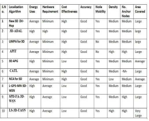
Table-1 Given the constraints of wireless sensor networks and the accuracy expected from localization algorithms in 3 dimensional spaces, range free localization algorithms are better as compared to the range based algorithms. The range free algorithms are cost effective and accurate as well. After the extensive survey of recent works and after studying various algorithms for 3D localization, APIT scheme is found to perform better in harsh terrain and can be used in various applications.
The APIT algorithm has less overhead is cost effective and the performance does not degrades when random node placement or irregular radio patterns are considered. The review of recent works in 3D localization makes it clear that the range free methods for localization in 3D plane are much more effective and accurate as compared to the range based methods.
The study shows that the range free methods are capable of supporting various applications in sensor networks in a much efficient ways as compared to other methods available.
The table 1 compares different algorithms available for 3D localization. These algorithms and their working was studied in detail and various parameters were considered for a fair comparison.
Table 1
From the Table1, it becomes very clear that although there are many algorithms available for the purpose of 3D localization, most of them need to improve their performance in some or the other field. The table 1 shows a comparative study in between 10 algorithms and clearly points out their major advantages and disadvantages.
V. REFERENCES
[1] A New 3-dimensional DV-Hop Localization Algorithm ,Li
WANG, Jing ZHANG, Dun CAO, Journal of
Computational Information Systems 8: 6 (2012) 2463-2475.
[2] 3D-ADL: A Three Dimentional Distributed range-Free Localization Algorithm for Wireless Sensor Networks Based on Unmanned Aerial Vehciles, Guerrero,E. Alvarez,J. Rivero,L. ,Digital Information management (ICDIM), 2010 Fifth International Conference.
[3] Samira Afzal, “A Review of Localization Techniques for Wireless Sensor Networks”. Text Road Publication ISSN 2090-4304 Journal of Basic and Applied Scientific Research www.textroad.com, 2012-09-27.
[4] Azzedine Boukerche, Horacio A. B. F. Oliveira, Eduardo F. Nakamura, and Antonio A. F. Loureiro, “Localization Systems for Wireless Sensor Networks”. IEEE Wireless Communications, December 2007.
[5] JiZeng Wang, Hongxu Jin, “Improvement On APIT
Localization Algorithms For Wireless Sensor Networks”, Networks Security, Wireless Communications And Trusted Computing, 2009.International Conference on, Vol.1, No., Pp.719-723, 25-26 April 2009.
[6] P.K Singh, Bharat Tripathi, Narendra Pal Singh,“Node Localization in wireless sensor Networks”, P.K.Singh et al / (IJCSIT) International Journal of Computer Science and Information Technologies, Vol. 2 (6) , 2568-2572 Year 2011.
[7] Li Wang, Jing Zhang, Dun Cao. “A New 3-dimensional
DV-Hop Localization Algorithm”. Journal of
Computational Information Systems 8: 6 (2012) 2463-2475, March 2012.
[8] Hongyang Chen, Pei Huang, Marcelo Martins, Hing Cheung, and Kaoru Sezaki. “Novel Centroid Localization
Algorithm for Three-Dimensional Wireless Sensor
Networks”.IEEE 978-1-4244-2108-4/2008.
[9] Guerrero E, Wang Hao, Alvarez J, Rivero L,” A Three-Dimensional Range-Free Localization Algorithm Based on Mobile Beacons for Wireless Sensor Networks”. Vol. 20 No.1 June 2010.
[10] Quan LIU, Ping REN, Zude ZHOU,” Three-dimensional Accurate Positioning Algorithm based on Wireless Sensor Networks”. Journal of Computers, Vol. 6, No. 12, December 2011.
[11] Three-dimensional Accurate Positioning Algorithm based on Wireless Sensor Networks, Quan Liu, Ping Ren, Zude Zhou, journal of computers, Vol. 6, No.12 December.
[13] N. Bulusu, J. Heidemann and D. Estrin, GPS-less Low Cost
Outdoor Localization for Very Small Devices,
IEEEPersonal Communications Magazine, 7(5):28-34, October 2000
[14] N. Bulusu, J. Heidemann and D. Estrin, Density Adaptive Algorithms for Beacon Placement in Wireless Sensor Networks, In IEEE ICDCS ‟01, Phoenix, AZ, April 2001.
[15] N. Bulusu, J. Heidemann, D. Estrin and T. Tran, Self
configuring Localization Systems: Design and
Experimental Evaluation, ACM Transactions on Embedded Computing Systems (TECS), Special Issue on Networked Embedded Computing, 2003.
[16] J. Caffery, Jr. A New Approach to the Geometry of TOA Location, In IEEE Vehicular Technology Conference (VTC), Boston, Mass, September 2000.
[17] Localization scheme for three dimensional wireless sensor networks using gps enabled mobile sensor nodes, VibhaYadav, Manas Kumar Mishra, A.K. Sngh and M. M. Gore, International Journal of Next-Generation Networks. (IJNGN),Vol.1, No.1, December 2009
[18] L. Doherty, L. E. Ghaoui and K. S. J. Pister, Convex Position Estimation in Wireless Sensor Networks, In Proceedings of the IEEE INFOCOM „01, Anchorage, AK, April 2001.
[19] D. Estrin, R. Govindan, J. Heidemann and S. Kumar, Next Century Challenges: Scalable Coordination in Sensor Networks,InProceedings of MOBICOM „99, Seattle, Washington, 1999.
[20] D. Ganesan, B. Krishnamachari, A. Woo, D. Culler, D. Estrin and S. Wicker, Complex Behavior at Scale: An Experimental Study of Low-Power Wireless Sensor Networks, Technical Report UCLA/CSD-TR 02-0013, 2002.
[21] L. Girod and D. Estrin, Robust Range Estimation using Acoustic and Multimodal Sensing, In Proceedings of IROS„01, Maui, Hawaii, October 2001.
[22] Novel Centroid Localization Algorithm for Three-Dimensional Wireless Sensor Networks, Hongyang Chen, Pei Huang, Marcelo Martins, Hing Cheung So, and Kaoru Sezaki.
[23] T. He, J. A. Stankovic, C. Lu, and T. F. Abdelzaher,
SPEED: A Stateless Protocol for Real-Time
Communication in Sensor Networks, In Proceedings of IEEE ICDCS ‟03, Providence, RI, May 2003.
[24] J. Hightower and G. Boriello, Location Systems for Ubiquitous Computing, IEEE Computer, 34(8):57-66, August 2001.
[25] J. Hightower, G. Boriello and R. Want, SpotON: An indoor 3D Location Sensing Technology Based on RF Signal Strength, University of Washington CSE Report #2000-02-02, February 2000.
[26] X. Hong, K. Xu, and M. Gerla, Scalable routing protocols for mobile ad hoc networks, IEEE Network magazine, vol 16, No. 4, 2002.
[27] B. Karp and H. T. Kung, GPSR: Greedy Perimeter Stateless Routing for Wireless Networks, In Proceedings of MOBICOM ‟00, New York, August 2000.
[28] L.Kleinrock and J.Slivester, Optimum transmission radii for packet radio networks or why six is a magic number, Inproceedings of national Telecomm conference, Pages 4.3.1-4.3.5, 1978.
[29] Connectivity-based and Anchor-Free Localization in Large-Scale 2D/3D Sensor Networks,Guang Tan, Hongbo Jiang, Shengkai Zhang, and Anne-Marie Kermarrec, ACM International Symposium on Mobile Ad Hoc Networking and Computing (MobiHoc) (2010).
[30] J. Li, J. Jannotti, D. S. J. De Couto, D. Karger and R. Morris, A Scalable Location Service for Geographic Ad-Hoc Routing, In Proceedings of MOBICOM ‟00, New York, August 2000.
[31] MICA Sensor Board Information, http://www.xbow.com
[32] R. Nagpal, Organizing a Global Coordinate System from Local Information on an Amorphous Computer, A.I. Memo 1666, MIT A.I. Laboratory, August 1999.
[33] R. Nagpal, H. Shrobe, J. Bachrach, Organizing a Global Coordinate System from Local Information on an Ad HocSensor Network, In the 2nd International Workshop on Information Processing in Sensor Networks (IPSN '03), Palo Alto, April, 2003.
[34] J. C. Navas and T. Imielinski, Geographic Addressing and Routing, In Proceedings of MOBICOM ‟97, Budapest, Hungary, September 26, 1997.
[35] D. Nicolescu and B. Nath, Ad-Hoc Positioning Systems (APS), In Proceedings of IEEE GLOBECOM „01, November 2001.
[36] Chia-Ho Ou and Kuo-Feng Ssu. (2008) “Sensor position determination with flying anchor in three dimensional wireless sensor networks.” In IEEE Transactions on Mobile Computing, pages 1084--1097, September 2008.
[37] Jiang Jin, Yi Wang, Chen Tian, Wenyu Liu and Yijun Mo. (2007) “Localization and synchronization for 3d underwater acoustic sensor networks.” In Springer, Ubiquitous Intelligence and Computing 2007, pages 622--631, Hong Kong, China, July 2007.
[38] Yu-Chee Tseng, You-Chiun Wang. (2008) “Efficient placement and dispatch of sensors in wireless sensor network.” In IEEE Transactions on Mobile Computing, pages 262--274,February, 2008.