TOPOGRAPHIC SURVEYS CARRIED FOR DRAWING
GENERAL URBAN PLAN OF A VILLAGE FOR
AGROTOURISTIC ARRANGEMENT
CĂLINA A., CĂLINA JENICA, BUZATU C. University of Craiova, Faculty of Agriculture
Keywords: urban plan, technical documentation, landscaping, agrotourism
ABSTRACT
The paper aims at presenting a methodology and surveying equipment and technical documentation needed for the general urban plan, indispensable for agrotouristic arrangement works of a settlement. The investigations undertaken have shown that for preparing fast, accurate and detailed urban plan for the studied locality was necessary use of modern surveying technology, such as GPS technology, completed with the total station for surveying the details. It was also found that only use of such a method could produce a unitary and accurate urban plan with high efficiency, compliant with all requirements and technical standards imposed by law, for such work of great importance and complexity. Having the plan and technical data gathered from the field can be achieved in the best conditions a design and implementation at the highest level, of agrotouristical arrangement works in the locality.
INTRODUCTION
General Urban Plan includes analysis, urban planning regulations and local regulations for the entire territory of the commune studied, defined according to Law. 2/1968 for both built areas of the city (village center of Albeni and villages Bîrzeiu de Gilort Bolboceşti, Doseni, Pruneşti) and for non-agricultural and agricultural land of the town.
The works were carried out according to Law. 50/1991 on authorizing the construction and some measures for housing, law followed by the M.L.P.A.T. Order no. 91/1991 regarding the content of the urbanism documentations, legal framework completed by the General Urbanism Regulation approved by Government Decision nr.525 / 1996, with subsequent amendments and completions, all providing the legal basis for all urbanism and spatial arrangements documentations.
Considering the particularities of the areas and each locality, also urban planning activities must take into account and reflect the demands of the population, an extremely important aspect is ensuring the participation all interested and involved factors in which the information and support of the population as active and involved factor, it becomes a regular part of urbanism and spatial arrangement activities.
MATERIAL AND METHOD
The conducted topographic survey on drafting the general urban plan, besides presenting the current situation analyzes and dysfunctions of communities, making diagnosis of the current situation and based on them are made viable proposals which take into account new developments of the village to a market economy characterized by increased mobility.
The need for a new project of urban development has imposed the need to try to eliminate the serious deviations produced in the period before 1990, when the work of systematization was used as an instrument of dictatorial policy subordinated arbitrarily by ignoring the views of a large part of the population .
economic and human potential available with social and cultural aspirations of the population. In parallel to the directions of perspective development of the commune, general urban plan will have to give an answer to immediate problems facing the mayor and his team especially in determining the categories of interventions, permissions and restrictions first step necessities and implicit those of touristic arrangement.
Items pursued in touristic arrangement strategy are: (after Honţuş Adelaida, 2005 Calina A., 2007) - the harmonious integration of new buildings into the natural frame assembly, putting into value the human resources; - diversification of basic and complementary facilities, in order to provide a wide range of tourism services - creating a Travel offers with emphasizing the specificity and originality, using land quality and characteristics of civilization and culture of the area; - providing a possible flexibility of offer, according to the tourist, enabling the development and continuous adaptation -rigorous sizing of the new buildings, particularly of the resorts, avoiding the danger of tourism agglomeration and landscape degradation; - prioritizing different types of tourism services, in line with nature and scale of the area, focusing on services corresponding to the highest degree of quality and quantity, preferences of tourists; - endowment various points of the area with auxiliary facilities to practice a wide range of forms of tourism; -ensure optimal functionality of the tourism activity in the area, starting with the accessibility, car park, accommodation, meals, transportation, other services and finishing with animation, general ambience; - ensuring a high economic and social efficiency of the entire tourism activities parallel to provide quality services.
RESULTS AND DISCUSSION
Given the scope and size of the measurements necessary to achieve - about 630 ha, it started from the preparation of a desk study - conceptual - developed on existing topographical base or limit of the administrative - territorial unit, received as a database along with the notice of beginning of the work, the trapezoids:
- L-34-108-C-c-2-III până la –L-34-108-C-c-2-IV - L-34-108-C-c-2-II până la –L-34-108-C-d-2-III - L-34-120-A-a-2-II până la L-34-120-A-a-2-II
- coordinates of the higher order topographic points and existent orthophotomap of the area.
The surface of Albeni according to the situation from Cadastre and Land Registration Office Gorj is 4510,1248 ha.
From the existing higher order topographic points on administrative - territorial unit Bolbosi have retained points: Dr.Albeni landmark, Colibaşi church, Pruneşti church, Mirosloveni church, Cerbu (Rânca) relay, Dl. Mare Pruneşti landmark, Poiana Frasinului (Pruneşti) landmark, Maghereşti line, Bolboceşti church.
After movement on the field and inspections made on the points of the state network that can be used to make the work, they were found points of order V, as follows: Dr. Albeni landmark in the west (Câmpu Mare) oriented on Cerbul (Rânca) relay with verification on Colibaşi church; Maghereşti line with orientation on Bolboceşti church.
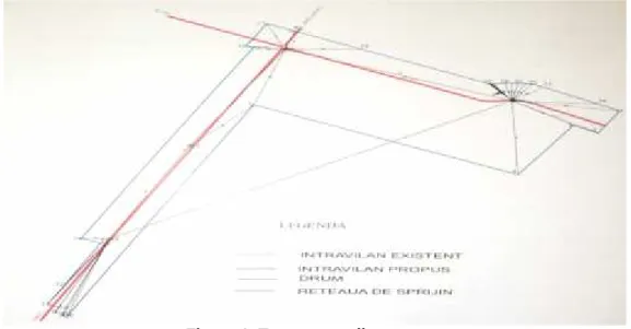
To achieve its objectives was used a traverse with two fixed points and two fixed guidelines, which outline with the arrangement of stations is shown in Figure 1. The traverse was covered by a number of 34 topographic stations materialized on the ground by 14 concrete landmarks and 20 iron pickets.
accuracy by 1 mm / 1500 m to measure distances and 2 seconds to measure horizontal and vertical angles (Neuner J., 2002, Călina A., et al., 2015). For long distance readings (start and end points) was used honeycomb prism placed on a tripod. Also, for the determination of support points was used GPS technology, applying static method (Păunescu C., 2012, Călina A., et al., 2014).
Topographical method used for details was the classic method of traverse with radiated points. They surveyed a total number by 6598 sideshot. Mainly as points of detail were raised the limits the county, communal, vicinal roads, passing through villages. At the setup of detail points was taken into account the provisions of the norm C110 / 1987 (Onose D.,2004, Călina Jenica, et al., 2014).
Figure 1. Traverse outline
Topographic office work consisted of processing field data required for making topographical plans at the scale of 1: 5000. Writing plans 1: 5000 was done in accordance with STAS, on tape plan sheets realizing a number of 6 situation plans at scale 1: 5000; -1 framing in the area map at scale -1: 20000.
On the plans drawn to scale of 1: 5000 were represented details from the field according to the atlas of conventional signs. Have been determined the limits of county, communal and vicinal roads, passing through villages, was determined road axis and from centreline of road to the left and right side was determined distance of 75 m, which are the limit of built area.
The distance of 75 meters was not preserved when on built area limit intervened waterways, culverts, in this case the urban limit being imposed by the watercourse limit. In some cases, on the surface of a village was built not only on buildable area, and there isolated objects.
For the specification of areas which constituted limit of the old builted area were scanned the plans from documentations of old PUG, areas being determined by vectorization (Table 1).
Table 1 The territorial balance
Village Existing buildable surface Proposed buildable surface
Albeni S1=3998 m2;S2=587058 m2
S3=970992 m2;
TOTAL=1562048 m2
S1=1643978 m2;S2=11666 m2
S3=1167864 m2;S4=5476 m2
TOTAL=2828984 m2
Bolbocești S1=602982 m2 S1=590810 m2
Doseni S1=93922 m2 S1=91840 m2
Mirosloveni S1=409717 m2 S1=506716 m2
Prunești S1=198282 m2;S2=271096 m2 S1=469378 m2
Total 3219287 m2 4608016 m2
Approval and reception of specialized works is requested to Territorial Office for works which relate to the territory of a single county or the National Agency for works which relate to the territory of several counties, and for obtaining the OCPI approval must be followed certain stages. The notice of beginning of the work is delivered to ensure technical Reception for: - works of land measurements; - Cartography works; - General cadastre works.
The purpose of issuing the notice of commencement of work is to establish conditions for the execution and use of available resources, such as: - an indication of regulatory framework governing carrying out the work; - consulting work with similar characteristics; capitalization of existing works; use of a uniform reference system; standardizing procedures, content and presentation of specific documents on the work; -certification of technical solutions envisaged for carrying out the works.
Opinion is requested by more than one month before work starts and submitted along with a copy of the related documentation, available until the execution deadline specified in the notice. It is drawn up in duplicate, one copy is sent to the applicant and the other copy remains in the issuer's notice, together with the documentation for approval.
Approval transmitted to the applicant shall include the specification of data and documents that will be used and valued, and the rules, guidelines and methodologies to be followed in the execution of the work. The approval shall specify the performance requirements for these categories of works and the data geodetic cartographic and cadastral that will be available to the issuer notice on finishing of the work.
The papers and the specialty documentation contracted by the National Agency or subordinate units does not require obtaining the approval.
Reception of specialized work
Reception of specialized work aims to verify the conditions accomplishment imposed by the regulations of execution, methodologies and guidelines developed by the National Agency, the technical standards in force and approval issued. Reception of specialized work covers: -reception of land measurements works; -reception of cartography works; -reception of general cadastral works.
They are subject to reception: - support networks and densification on surfaces larger than 100 km2; - Networks of densification smaller than 100 km2 and surveying
networks, along with reception of works in which are integrated; - parts of geodesy, cartography and general cadastre from works to achieve informational systems specific to sphere of activity.
407/2005 regarding certain measures prior to the rehabilitation and expansion of the public railway infrastructure.
Reception of specialized work for which has issued notice to start work is only possible if it demonstrates that the internal verification of the work, by the executant in the process of quality control. The results of control operations will be highlighted in the documentation to be issued in order to reception the work.
Internal check involves the control, by another specialist of the company, or if authorized individuals, of person who performed the work through a new working method, of the correctness of of carrying out fieldwork and office for at least 5% of the work.
Internal quality control report must include at least: - the name of the person who performed the operation / work; - Name of the person / persons that has / have carried out quality control; - The length of quality control; - Method used to control the operation / work - the results of quality control; - The number and type of errors found as a result of internal quality control; - Signature of the person / persons that has / have carried out internal quality control.
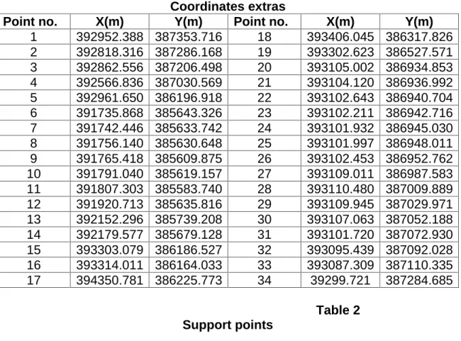
All coordinates determined were checked and verified before it was passed in the inventory coordinate table (Table 1) and may be used in future works of elaboration of PUG and touristical arrangement of the village.
Table 1 Coordinates extras
Point no. X(m) Y(m) Point no. X(m) Y(m)
1 392952.388 387353.716 18 393406.045 386317.826 2 392818.316 387286.168 19 393302.623 386527.571 3 392862.556 387206.498 20 393105.002 386934.853 4 392566.836 387030.569 21 393104.120 386936.992 5 392961.650 386196.918 22 393102.643 386940.704 6 391735.868 385643.326 23 393102.211 386942.716 7 391742.446 385633.742 24 393101.932 386945.030 8 391756.140 385630.648 25 393101.997 386948.011 9 391765.418 385609.875 26 393102.453 386952.762 10 391791.040 385619.157 27 393109.011 386987.583 11 391807.303 385583.740 28 393110.480 387009.889 12 391920.713 385635.816 29 393109.945 387029.971 13 392152.296 385739.208 30 393107.063 387052.188 14 392179.577 385679.128 31 393101.720 387072.930 15 393303.079 386186.527 32 393095.439 387092.028 16 393314.011 386164.033 33 393087.309 387110.335 17 394350.781 386225.773 34 39299.721 387284.685
Table 2 Support points
Reception request and documentation attached to it is distributed to specialized staff who will analyze and submit their response to one of the variants: reception report;
-Point no. X(m) Y(m)
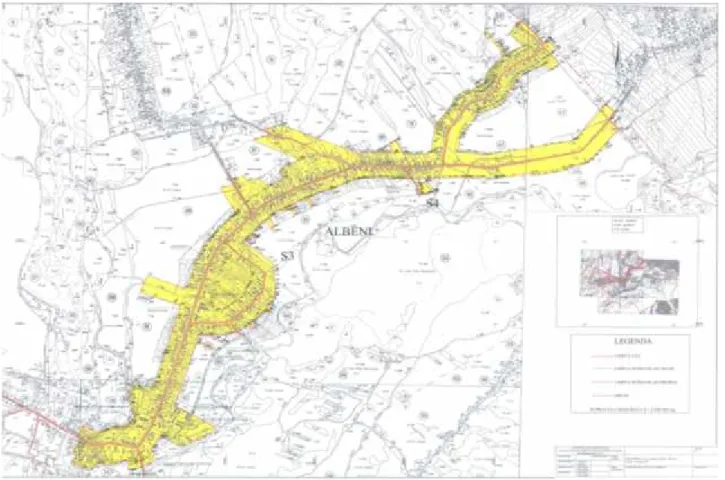
completing note in the case of request for additional data, addition or restoration work; -reception of plans and maps made under Law 50/1991 (Figure 2.), on authorizing the execution of construction works and subsequent amendments, Law 350/2001 on regional planning, as amended and supplemented, Law 198 / 2004 on certain measures prior to the construction of highways and national roads amended and supplemented and the Law 407/2005 on some measures prior rehabilitation and expansion of public railway infrastructure, will be concluded with approving by stamp, signature and date, by specialist inspector performing reception. Reception report is drawn up in four copies, two copies shall be sent to the applicant and the other copies remain on the issuer's approval, together with the documentation for reception.
Reception of specialized work is carried out, where appropriate, regional offices or the National Agency, based on those established by the issuer of the approval of initiation of work.
Figure 2. Topographical plan necessary for work approval and reception
Currently because holiday preferences of the tourists are turning increasingly towards rural areas which responding to their desire to return to nature, to life and traditional occupations, in future touristical arrangement will be accomplished by specialist that should follow some principles of organization and operation, namely: - the principle of flexibility or evolutionary structures; the principle of harmonious integration of buildings; -optimal functionality principle of the whole network system; - principal activity and secondary reception bridging principle - the principle of networks interdependence; - the principle of direct and indirect return (Honţuş Adelaida, 2005, Călina Jenica, 2015).
refers to "avoid desertification of certain regions" because it was found that rural tourism and agritourism leading to the exploitation and maintenance of life in rural areas.
Generally after specialized data knows that in rural areas arranging there are fewer constraints compared to other types, the touristical implantation being determined by specific elements of each relief area. Among the factors that condition the selection of areas and the types establishments are: peace, space (extention), vegetation, positioning in relation to road traffic, the presence of a natural curiosity or monument, local architecture, traditions and others. A special place among these factors it has the opportunity to be part in the village life. This aspect coupled with the desire to return to places of origin, generated a particular form of rural tourism namely, agrotourism, which implies a higher recovery of economic, natural and anthropogenic valences of the area through tourism, focusing on an interconditioning of the traditional side with modern tourism requirements, competitive, the co-participation and mutual cohabitation being defining elements.
From research and analyzing tourist equipment in rural locality in different countries, we have identified two steps that can be used in tourism arrangement of the locality studied (period) (Honţuş Adelaida, 2005, Aurel Călina, Jenica Călina, 2015):
- first, called the "individual implants" which is characterized by a somewhat anarchic development of equipment, which are located and designed without taking account of the specific economic and social environment;
- second, called "concerted arrangement", in which the new implants are reported imperatives complex development of rural areas and are designed in an integrated to tourism products thus created tend to complement each other;
Choice of rural arrangement, regardless of the structuring, in "individual" or "concert"implantation, highlights their diversity, combined with efforts to adapt to the specific conditions of each area, it not building on rigorous calculations or regulations, as in other types of arrangement, but the assessments of tourist flows and the need to balance the zones.
CONCLUSIONS
1. The goal of survey is to obtain the OCPI approval for drawing PUG to extend the built area and touristic arrangement, which involved performing a preliminary step particularly important, which has carried out a detailed documentation on the situation on the ground and was drafted preliminary based on existing terrain.
2. Topographical measurements were conducted with new generation electronic surveying which enabled obtaining data in the field which were within all the rules and standards required of such works, these leading also to obtain precision and high efficiency both measurements and data processing.
3. When drawing up the General Urban Plan of the village studied specialist must fully respect a conceptual endeavor that highlights the main directions in which to stop failures in the economic, demographic, public utilities and environmental quality on the one hand, and on the other hand the installation of rehabilitation and growth trends of activities of rural tourism and agrotourism.
4. During preparation of documentation and processing of data was referred for each parameter in the development of village priority guidelines and directions of action, targeting the communications network of roads, telecommunications, water management complex, gas supply and especially the tourism planning.
subject to approval by the City Council, after which it will become mandatory for institutions public legal persons, but also for the population
REFERENCES
1. Călina A., Agrotourism and household construction and agricultural arrangements, Ed. SITECH, Craiova, 2007
2. Calina, A. et al., 2014. Engineering topography. Sitech Publishing, Craiova, pp.131.
3. Calina Aurel, Calina Jenica, Milut Marius, 2015, Study on Levelling Works Made for Drawing Tridimensional Models of Surface and Calculus of the Volume of Earthwork
Agriculture and Agricultural Science Procedia, Conference Agriculture for Life, Life for Agriculture,Volume 6, Pages 413–420.
4. Aurel Călina, Jenica Călina, Research on the production of forage for the agro -touristic farms in Romania by cultivating perennial leguminous plants, Environmental Engineering and Management Journal March 2015, Vol.14, No. 3, 657-663
http://omicron.ch.tuiasi.ro/EEMJ/
5. CĂLINA Jenica, CĂLINA Aurel, BĂBUCĂ Nicolae,- Study on the implementation of GIS databases in achieving the general urban plan, International Scientific GeoConferences SGEM VOL. 1,Ed. STEF92 Technology, Ltd. Sofia, Bulgaria, Pg. 817-824, ISSN 1314-2704 , ISBN 978-619-7105-20-9 http://www.sgem.org/sgemlib/spip.php? article4102, ,2014
6. CĂLINA Jenica, A. CALINA,The evolution of agritourism demand in Romania, 2nd International Multidisciplinary Scientific Conference on Social Sciences and Arts SGEM2015 , SGEM2015 Conference Proceedings, ISBN 978-619-7105-48-3 / ISSN 2367-5659 , Aug 26-Sept 01; Book 2, Vol. 3, 839 - 846 pp, www.sgemsocial.org
7. Honţuş Adelaida, 2005, Agricultural tourism planning, Course ID,USAMV-Bucureşti, pp. 80-220.
8. Neuner, J., Badea Gh., 2002. Land measurements – fundaments. vol.I. Matrix Rom Publishing, Bucharest, pp.76.
9. Onose, D., 2004. Topography. Matrix Rom Publishing, Bucharest, pp. 178.
10. Paunescu, C. et al., 2012. The position determination system using GNSS satellites. Bucharest University Press, Bucharest.
11. XXX Legea 2/1968 12. XXX Legea 50/1991
13. XXX Ordinul M.L.P.A.T., 91/1991 14. XXX Hotărârea Guvernului 525/1996 15. XXX Hotărârea Guvernului 834/ 1991 16. XXX Legea 350/2001