12. S
ITE
1219
1Shipboard Scientific Party
2BACKGROUND AND OBJECTIVES
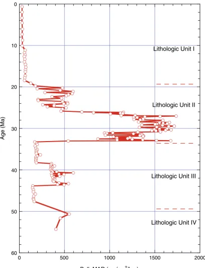
Site 1219 (7°48.019′N, 142°00.940′W; 5063 meters below sea level [mbsl]; Fig. F1) is the southernmost site to be drilled on the 56-Ma tran-sect during Leg 199 and is situated ~3° to the north of the Clipperton Fracture Zone on abyssal hill topography. The age of basement at Site 1219 was poorly constrained prior to Leg 199 because little reliable magnetic anomaly data are available between the Clipperton and Clar-ion Fracture Zones (Cande et al., 1989). At the outset of Leg 199, based on one interpretation of the location of magnetic Anomaly C25r (~57 Ma) (Petronotis et al., 1994), previous drilling, and assumed spreading rates, we estimated the age of basement at Site 1219 to be ~55 Ma. Site 1219 is the only site to be drilled during Leg 199 that features all of the seismic horizons identified for a Paleogene equatorial seismic stratig-raphy (Lyle et al., this volume), and an estimate of sediment thickness at Site 1219 prior to drilling (based upon the seismic reflection profile; Fig. F2) was 270–290 meters below seafloor (mbsf), depending on which reflection was chosen as basement.
Based upon a fixed hotspot model (Gripp and Gordon, 1990, for 0- to 5-Ma Pacific hotspot rotation pole; Engebretson et al., 1985, for older poles), Site 1219 should have been within 2° of the equator between 40 and 21 Ma and should have crossed the equator at 29 Ma. Thus, the sediments should record equatorial conditions from the late middle Eocene to the early Miocene. In addition, Site 1219 should provide an analog for Site 1218, except that it is on older deeper crust.
Site 1219 will be used to study near-equatorial ocean circulation from the late Paleocene to the late Eocene including deepwater flow and sea-surface properties. Sediment records from this site will help to define the carbonate compensation depth (CCD) and lysocline during the Eocene–Oligocene transition and near the Oligocene/Miocene (O/M) boundary. Based on the results from a site survey piston core
(EW3709-160°W 150° 140° 130°
0°
10°
20°
30°
N
0 500 1000 Site 1215 Site 1216 Site 1217 Site 1218 Site 1219 Site 1220 Site 1221 Site 1222 Site 40 Site 42 Site 43
Site 69 Site 70 Site 71 Site 72 Site 160 Site 161 Site 162 Site 163 Site 573 Site 574 Site 575 Honolulu
Molokai F.Z.
Clipperton F .Z. Clarion F.Z.
Site 1216 Site 1217 Site 1218 Site 1222 Site 1221 Site 1220 Site 1215 Molokai Fractu re Zone
Clarion Fracture Zone
Mahi M ahi Fracture Zone
Site 1219 Clipp erton Fractu re Zone 574 573 575 161 162 163 40 42 43 70 71 72 0° 10° 20° 5° 15° 25° N 150°W 145° 140° 135° km
Leg 199 sites DSDP sites F1. Site location map, p. 42.
T w o-w a y tr a v eltime (ms) Hour Minute 6500 6700 6800 6900 7000 7100 6600
X Line 5 X Line 1
N S Site 1219 PAT-17 7200 7300 7400 PAT17-Line 3 Bandpass 3 km
P2
P3 P4
P5
Y
Y 23 Ma 29 mbsf
P5 26 Ma 67 mbsf
P4 31 Ma 115 mbsf ~40 Ma 169 mbsf ~50 Ma 215 mbsf ~55 Ma 270 mbsf
P3
P2 Basement F2. Seismic reflection profile, p. 43.
1Examples of how to reference the
whole or part of this volume.
2Shipboard Scientific Party
addresses.
12PC; Lyle, 2000) taken a few kilometers to the southwest, we antici-pated that Site 1219 passed below the CCD in the early Miocene. The basement at Site 1219 should have formed in the Southern Hemisphere, and changes in magnetic inclination at this site will be important to de-fine the position of the equator in the early Eocene.
SUMMARY
Site 1219 (7°48.01′N, 142°00.94′W) is the southernmost site drilled during Leg 199. It is situated on the 56-Ma transect ~3° north of the Clipperton Fracture Zone and is located at a water depth of 5063 m on abyssal hill topography. The age of basement at Site 1219 was poorly constrained prior to Leg 199 because little reliable magnetic anomaly data are available between the Clipperton and Clarion Fracture Zones (Cande et al., 1989). At the outset of Leg 199, based on one interpreta-tion of the locainterpreta-tion of magnetic Anomaly An25r (~57 Ma) (Petronotis et al., 1994), previous drilling, and assumed spreading rates, we estimated the age of basement at Site 1219 to be ~55 Ma. Site 1219 is the only site drilled during Leg 199 that features all of the seismic horizons identi-fied for a Paleogene equatorial seismic stratigraphy (Lyle et al., this vol-ume).
Based upon a fixed hotspot model (Gripp and Gordon, 1990, for the 0- to 5-Ma Pacific hotspot rotation pole; Engebretson et al., 1985, for older poles), Site 1219 should have been within 2° south of the equator between 40 and 21 Ma and should have crossed the equator at 29 Ma. Thus the sediments should record equatorial conditions from the late middle Eocene–early Miocene. In addition, Site 1219 should provide an analog for Site 1218, except that it is on older, deeper crust.
Two holes were drilled at Site 1219. Hole 1219A was a remarkable op-erations success. We advanced to ~225 mbsf using Ocean Drilling Pro-gram’s (ODP’s) advanced piston corer (APC) technology, thereby achieving one of our high-priority objectives by recovering sediments suitable for whole-core magnetostratigraphy below the lower Oligocene (including the Eocene/Oligocene [E/O] boundary). Basement was reached at ~250 mbsf, shortly after switching to extended core barrel (XCB) coring. A full suite of downhole logs was obtained to the base of Hole 1219A, and the data are of high quality. In addition to these downhole logs, multisensor track (MST) data from the uppermost Eocene to the lowermost Miocene interval in this hole bore a striking resemblance to those recovered from Site 1218, so much that it was pos-sible to correlate between Sites 1218 and 1219 (which are separated by 7° of longitude and 1° latitude, or ~800 km) to a submeter scale.
Sedi-mentation rates over the Oligocene interval were ~16% slower than at Site 1218, based upon the site-to-site correlation.
The sediment column at Site 1219 has a strong resemblance to that of Site 1218. Thirty meters of clay (lithologic Unit I) overlies Oligocene– lower Miocene nannofossil ooze (Unit II; 30–151 mbsf). Strong cyclic variations in nannofossil content are apparent in both the upper and lower parts of Unit II. An abrupt change in lithology from nannofossil ooze to radiolarian clay and clayey radiolarian ooze occurs at 151 mbsf within the E/O boundary interval. The lithologic change marks the up-per boundary of lithologic Unit III: an upup-per and middle Eocene unit composed of radiolarian ooze and radiolarian clay, becoming radiolar-ite, chert, and zeolitic clay at the base. A short section in Unit III within polarity Chron C18r (40.1–41.3 Ma) contains alternating diatom and nannofossil ooze. Below the cherty, clay-rich section at the base of Unit III are the chalks of lithologic Unit IV (234–243 mbsf; ~53–54.8 Ma). The oldest sediments above basalt are slightly younger than the Paleocene/Eocene (P/E) boundary.
Natural remanent magnetization (NRM) intensity of the sediments at Site 1219 is relatively strong, and the magnetic overprint from drilling can be mostly removed by alternating-field (AF) demagnetization. An excellent record of magnetic reversals was made for the entire APC-cored sediment section (0–223 mbsf), from Pleistocene Chron C1n to early middle Eocene Chron C20r (43.8–46.3 Ma). This remarkably clean magnetic reversal stratigraphy allows us to calibrate biostratigraphic events and to develop detailed sedimentation-rate curves downhole to lower middle Eocene sediments. Inclination patterns in discrete sam-ples show that at least the lower part of the sedimentary section was lo-cated in the Southern Hemisphere during deposition. The mean incli-nation depicts a time-averaged paleolatitude of 1.6°S for the site, but this result is preliminary and will require further testing. The paleotude inferred from the inclination is consistent with the expected lati-tudes as calculated from both paleomagnetic pole positions and those based upon a fixed hotspot model.
Nannofossils are present to abundant in the Oligocene–middle Miocene sediments (~151–10 mbsf) but absent from upper Eocene sedi-ments. Nannofossils reappear briefly in polarity Chron C17r (~38.3 Ma) in the middle Eocene, disappear, and then reappear and are present be-tween the middle of polarity Chron C18r to the base of C20n (~40.5– 43.8 Ma) and are found in the chalk in the lower Eocene interval. Planktonic foraminifers are present in the lower Miocene–Oligocene sediments and in the lower Eocene chalks. Preservation quality and abundance are highest in the lower Miocene (Zones M4–M2) and the middle part of the Oligocene (Zones P20 and P21). Benthic foraminifers are consistently present and well preserved through the Miocene and Oligocene at Site 1219 but are scarce and very poorly preserved through much of the Eocene sections. Radiolarians were found in all cores ex-cept the deepest one (Core 199-1219A-27X), which recovered chalk over basalt basement.
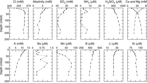
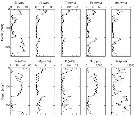
last glacial maximum into the sediments. Bulk-sediment geochemical analyses from Site 1219 reflect the shifts in lithology back and forth be-tween sediments dominated by silica and carbonate. Clay-rich units are high in Ti and Al but are also high in Fe and Mn, presumably reflecting the deposition of authigenic ferromanganese oxyhydroxides. Physical properties of the sediments also primarily reflect lithology. The carbon-ate sediments are higher in density, lower in porosity, and lower in magnetic susceptibility (MS) than the clay or radiolarian ooze litholo-gies. This is true even on a fine scale (see Fig. F29 and “Physical
Prop-erties,” p. 28). The radiolarian ooze has higher compressional wave
ve-locity than the carbonates despite having higher average porosity.
Highlights
Magnetic Reversal Stratigraphy
The clean record of magnetic reversal history for Site 1219 (for the entire APC-cored sediment section; 0-223 mbsf) from the Pleistocene down to Chron C20r (43.8–46.3 Ma) is remarkable for a tropical site and, together with the superb cyclostratigraphic correlations to Site 1218 (see “MST Correlation to Site 1218,” p. 4), will provide invalu-able time control for shore-based high-resolution paleoceanographic studies.
MST Correlation to Site 1218
The MST data from Site 1219 bear a striking resemblance to those re-covered from Site 1218 from the middle Eocene–lowermost Miocene in-terval. The excellent match in these data sets between the two sites made it possible to align both records on a common (Site 1218 mcd) depth scale. The two records show such high quality correlation (down to the submeter scale) that successful a priori prediction of biostrati-graphic zones and magnetic reversals was possible at Site 1219. The mapping from Site 1219 mcd to Site 1218 mcd results in relative sedi-mentation rates at Site 1218 that are ~16% higher than at Site 1219 over the Oligocene interval. The remarkable fidelity of the correlation between these two sites, separated by more than 1° of latitude and 7° of longitude (~800 km), suggests that drilling results from these two sites are representative of large-scale paleoceanographic-forcing functions in the late Paleogene eastern equatorial Pacific Ocean. We anticipate that the continuously cored sediments from Site 1218 with supplementary control from correlative sediments in Site 1219 will provide a pale-oceanographic reference section for the late Paleogene tropical Pacific Ocean.
Oligocene–Miocene Transition
Sea Drilling Project [DSDP] Site 522) and the western equatorial Atlantic (Sites 926, 928, and 929) (Shackleton et al., 2000). Yet, the calibration of the S. delphix event to the geomagnetic polarity record is remarkably consistent in Subchron C6Cn.2 from the South Atlantic Ocean to the Mediterranean region (Raffi, 1999) and to the tropical Pacific Ocean (Site 1219).
Eocene–Oligocene Transition
The Eocene–Oligocene transition at Site 1219 is associated with an abrupt lithological change from radiolarian clays below to nannofossil ooze above. This transition is similar to but sharper than that observed at Site 1218, presumably reflecting higher rates of carbonate dissolution at Site 1219 (the contemporaneous paleowater depth is ~400 m deeper at Site 1219 than Site 1218). Together with drilling results from Site 1217, this finding offers exciting prospects for shore-based investiga-tion of the first Pacific Ocean depth and latitudinal transect across this important paleoceanographic boundary.
Eocene Sediments
The Eocene sediments at Site 1219 are dominated by radiolarian oozes from the period between ~45 Ma and the E/O boundary. Never-theless, there are intervals of carbonate within the section, most nota-bly at ~40.5 Ma but also at ~38.3 and ~43.5 Ma. These carbonate units can be detected by density, reflectivity, velocity, and light absorption spectroscopy (LAS) mineralogy as well as by chemical analyses and mi-croscopic examination of the sediments. The 40.5- and 38-Ma events are also found at Site 1218, but the oldest of these events is older than the base of the sediment column at Site 1218.
The lower–middle Eocene interval is represented by cherty sedi-ments that were not recovered by drilling. This is one of five sites on the 56-Ma transect where we encountered cherts in roughly the same interval. Immediately below the cherts at Site 1219 are zeolitic clays barren of microfossils, suggesting that the chertified interval was de-posited slowly. The uppermost lower Eocene chalk in contact with the zeolitic clay has an age of ~53 Ma (nannofossil Subzone CP9b), whereas the lowermost radiolarian ooze above the cherty interval is dated as ~46 Ma. Thus, the average sedimentation rate over the 10-m-thick cherty interval could be as low as 1.4 m/m.y. The interval has been condensed by diagenesis, but an estimate of the bulk mass accumula-tion rate (MAR) using sediment density measured by downhole logging (~2 g/cm3) is about half that of the sediments immediately above it.
The lower Eocene chalks were poorly recovered but appear to be typ-ical basal carbonate-rich sediments. There is little evidence of hydro-thermal sediments within the chalks.
OPERATIONS
Transit to Site 1219 (PAT-17C)
ves-sel came about and returned to site as the thrusters were lowered and the dynamic positioning system (DPS) was activated. The Global Posi-tioning System receiver interface to the DPS was employed to situate the vessel over the coordinates of the new location by 0200 hr. A bea-con was deployed at 0300 hr. The corrected precision depth recorder (PDR) depth was 5084.4 meters below rig floor (mbrf).
Hole 1219A
After the drill string was deployed to a depth of 5071 mbrf, the driller further lowered the bit until the heave compensator appeared to acti-vate, suggesting contact with a firm seafloor. The contact was at a bit depth of ~5075 mbrf. Hole 1219A was then spudded with the APC at 1200 hr on 23 November with the bit at 5071.0 mbrf. The seafloor depth indicated by the recovery of the initial core was 5074.5 mbrf. This depth was 9.9 m shallower than the PDR depth.
Hole 1219A was deepened to 224.5 mbsf with the APC before the XCB was deployed to accomplish the deeper objectives of the hole. Ori-entation began with Core 3H. All 24 piston cores were fully stroked events, but six core barrels (Cores 18H and 20H–24H) could not be pulled free of the sediment even with 80,000 lb of overpull. The core barrels had to be drilled over to release them from the sediment. The ac-tive heave compensator was engaged during drill-over operations for the majority of these cores. The average recovery in the APC section was 103.7% (Table T1).
XCB coring (Cores 25X–27X) deepened the hole from 244.5 to 250.8 mbsf. A small sample of basalt was obtained in the last core, confirming basement contact. XCB coring advanced 26.3 m and recovered 7.67 m (29.2%). The total recovery of Hole 1219B was 240.41 m, which repre-sents 95.9% of the cored interval (Table T1).
Downhole Measurements, Hole 1219A
To prepare the hole for logging, the drill string was pulled to 80.5 mbsf and then lowered back to 250.8 mbsf. The hole was then displaced with 100 bbl of 8.9 lb/gal sepiolite mud, and the bit was placed at the logging depth of 83.3 mbsf. Logging then began at 1530 hr on 25 No-vember.
The triple combo configuration with the multisensor spectral gamma ray tool (MGT) was deployed first. Two passes were made with the triple combo tool in Schlumberger mode followed by two passes in Lamont mode for MGT data acquisition. The triple combo configuration was followed by two passes of the Formation Microscanner-sonic (FMS-sonic) tool string. In all, six passes were made with no bridges encoun-tered, and the bottom of the hole was reached on all passes. Logging operations were completed by 1200 hr on 26 November (see
“Down-hole Measurements,” p. 33, for details of the logging operations).
Hole 1219B
After logging operations were completed, the bit was pulled free of the seafloor at 1230 hr on 26 November, and the vessel was offset 20 m north of Hole 1219A. Hole 1219B was spudded with the APC at 1330 hr on 26 November. In order to obtain a good stratigraphic overlap with results from the first hole, Hole 1219B was drilled to 21 mbsf before pis-ton coring was initiated. The plan for this hole was to deepen it with
APC/XCB coring to ~240 mbsf. This depth objective was thwarted when the core barrel containing Core 16H could not be retrieved with the wireline. The piston core was fully stroked and was pulled free of the sediment with a moderate amount of overpull (60,000 lb). However, the core barrel jammed in the BHA and could not be recovered in a rou-tine manner. The Kinley Cutter was used to sever the wireline, after which the drill string and BHA with the core barrel and Tensor tool, were recovered.
In light of the operational difficulties in Hole 1219B and the suc-cesses of both Hole 1219A and Site 1218, the shipboard party made a collective decision to abandon Site 1219 earlier than planned. This de-cision was made in order to target additional and more complete pro-grams at forthcoming sites having lower and middle Eocene objectives. The vessel departed for the next site (PAT-9D) at 0445 hr on 27 Novem-ber.
Sixteen piston cores were recovered at Hole 1219B with orientation starting on Core 1H. Heat flow measurements were obtained at 49.5 mbsf (Core 4H), 78.0 mbsf (Core 7H), and 116.0 mbsf (Core 11H). The average recovery in the Hole 1219B cores was 101.1% (Table T1).
LITHOSTRATIGRAPHY
The 286.1 m of sediment recovered at Site 1219 consists primarily of radiolarian and nannofossil ooze with varying clay contents in a se-quence similar to Site 1218 and DSDP Site 162. Lithologic descriptions are primarily based on sediments from Hole 1219A. The Neogene is rep-resented by 30 m of radiolarian clay and radiolarian ooze. About 120 m of nannofossil ooze, with variable radiolarian and clay content, comprises the lower Miocene and Oligocene sections at this site. A 95-m-thick Eocene section contains a diverse array of sediments including radiolarian and zeolitic clays, radiolarian and diatom oozes, and nanno-fossil oozes and chalks. Chert was encountered near the base of the Eocene section. Minor components throughout the sequence include diatoms, foraminifers, iron oxides, and zeolites. Other minor to trace components include fish teeth, sponge spicules, silicoflagellates, and volcanic glass.
The sequence is divided into five major lithologic units (Fig. F3). With the exception of the Unit I/II contact, all unit boundaries are sharp lithologic transitions (Figs. F4, F5, F6, F7). Physical properties data support our interpretation of lithologic units and subunits (see
“Physical Properties,” p. 28). Unit I extends from 0 to 30.0 mbsf (Hole
1219B: 21.0–29.2 mbsf) and consists primarily of radiolarian clay grad-ing to radiolarian ooze that is late Miocene–Holocene in age. Alterna-tions of nannofossil ooze with radiolarians and clay are present in the basal portion of Unit I. These variations are expressed as decimeter-scale, light–dark color cycles. Unit II, lower Oligocene–lower Miocene nannofossil oozes, begins at 30.0 mbsf and extends to 150.8 mbsf (Hole 1219B: 29.2–154.5 mbsf). The upper and basal portions of Unit II con-tain significant clay and radiolarian components, which are also ex-pressed as decimeter- to meter-scale color cycles. Subunit IIIA (Hole 1219A: 150.8–224.5 mbsf; Hole 1219B: 154.5–158.0 mbsf) begins at the lithologic transition associated with the E/O boundary and grades from a radiolarian clay to a radiolarian ooze. Approximately 10 m of radiolar-ite and chert, underlain by a zeolitic clay, comprises Subunit IIIB (Hole 1219A: 224.5–234.2 mbsf). Core recovery in the cherty interval of
Sub-Core
Depth (mbsf)
RecoveryCoreRecovery
Hole 1219AHole 1219B 10 middle Miocene early Miocene late Oligocene early Oligocene 20 30 40 60 70 80 90 110 120 130 RP20 P18 P19 P19 P20 P21 P22 M1 M4 CP17 CP18 CP19a CP19b CN3 CN4 CN1 CP16c CP16 RP21 RP22 RN1 RN2 RN4 RN5 RN3 140 50 100 150 Site 1219 1H 2H 3H 4H 5H 6H 7H 8H 9H 10H 11H 12H 13H 14H 15H 1W 2H
Drilled 0.0-21.0 mbsf
3H 4H 5H 6H 7H 8H 9H 10H 11H 12H 13H 14H 15H 16H 17H
Magneticsusceptibility(10
-6
SI ) Bulk density(g/cm
3) Magneticstratigraphy
Color reflectance( L*) Calcite(model wt%) Illite(model wt%) Smectite(model wt%) Opal(model wt%) Lithology Lithologic unitAge
Physical
properties LAS Mineralogy Downhole logging Zone
Naturalgamma ray(gAPI) Planktonicforaminifers
Calcareousnannofossils Radiolarians
I
II
0 40 80 1.2 1.6 2.0 307020602040206010 30 50 7010 20 30
M3+M2 Barren Barren Barren C5Bn.2n C5Cn C5Dn C5En C6n C6An.1n C6An.2n C6Bn.1n C6Bn.2n C6Cn.1n C6Cn.2n C6Cn.3n C7n.1n C7n.2n C7An C8n.1n C8n.2n C9n C10n C12n C1n C2n C2An C3n C3An C4n C5n
F3. Core recovery, corresponding lithologic units, and age, Holes 1219A and 1219B, p. 44.
199-1219A-4H-4 Unit I Unit II cm 50 60 80 70 40
F4. Unit I–II transition, p. 46.
199-1219A-17H-2 Unit II Unit III cm 70 80 100 90 60 50
F5. Unit II–III transition, p. 47.
199-1219A-26X-1 Unit III Unit IV cm 20 30 50 40 10 0
unit IIIB was poor. Unit IV spans the interval from 234.2 to 244.8 mbsf and contains extensively recrystallized nannofossil chalk and calcare-ous chalk that is early Eocene in age. The basal portion of Unit IV con-tains 20–30 cm of extensively altered chalk and basalt. Unit V consists of a fine-grained phaneritic basalt.
Unit I
Intervals: 1219A-1H-1, 0 cm, through 4H-4, 54 cm, and 199-1219B-1H-1 through 2H-6, 82 cm
Depths: 0.0–30.0 mbsf (Hole 1219A) and 21.0–29.2 mbsf (Hole 1219B)
Age: Holocene to early Miocene
Lithology: radiolarian clay and radiolarian ooze
The upper 14.6 m of Unit I consists of alternating radiolarian clay, clay with radiolarians, and clayey radiolarian ooze with the radiolarian fraction decreasing downhole. This is also expressed as a decrease in lightness (L*) and an increase in the red/blue (680 nm/420 nm; a*/b*) ra-tios in spectral reflectance (Fig. F8). Lithologic alternations are seen as half-meter to meter-scale, light–dark cycles. Clay layers range from dark yellowish brown (10YR 4/4) to very dark grayish brown (10YR 3/2) in color, whereas ooze intervals range from yellowish brown (10YR 5/4) to dark gray (7.5YR 3/2). Mottles are abundant in the clayey radiolarian ooze, common in the other lithologies, and tend to be light yellowish brown (10YR 6/4). Contacts between interbeds tend to be gradational and overprinted by bioturbation. Diatoms and iron oxides are minor components (up to 10%). Trace amounts (<5%) of silicoflagellates and volcanic glass are present throughout.
Below 14.6 mbsf, the biogenic fraction is dominant, and the princi-pal lithology is radiolarian ooze. Color ranges from very dark brown (7.5YR 2.5/2) to dark brown (7/5YR 3/2) and lightens downcore, reflect-ing a relative decrease in the clay and an increase in the nannofossil component. Mottles are common in the radiolarian ooze. Contacts are gradational and heavily bioturbated. Diatoms, sponge spicules, and iron oxides are minor components, and foraminifers and volcanic glass are present in trace amounts.
Decimeter-scale alternations of nannofossil ooze with radiolarians and clay and nannofossil radiolarian ooze are present between 19 and 24 mbsf. These minor lithologies exhibit a marked increase in lightness and a decrease in the red/blue spectral ratio and range from yellowish brown (10YR 5/4) to dark brown (7.5YR 3/3) in color. Mottles are abun-dant and tend to be very pale brown (10YR 7/4) to yellowish brown (10YR 5/4).
Unit II
Intervals: 1219A-4H-4, 54 cm, through 17H-2, 86 cm, and 199-1219B-2H-6, 82 cm, through 16H-1, 45 cm
Depths: 30.0–150.8 mbsf (Hole 1219A) and 29.2–154.5 mbsf (Hole 1219B)
Age: early Oligocene to early Miocene
Lithology: nannofossil ooze and nannofossil ooze with radiolarians and clay
199-1219A-27X-CC
Unit IV Unit V cm
20
40 30 10 0
F7. Unit IV–V transition, p. 49.
Color reflectance (L*)
Depth (mbsf)
60 100
20
Red/Blue (a*/b*)
0.4 0.8
0
Unit IV Unit V Unit III-B Unit III-A Unit II Unit I
0
100
200 50
150
The dominant lithology in Unit II is nannofossil ooze, with signifi-cant siliceous components in the upper (radiolarians) and basal (radio-larians and clay) portions. Clay and radiolarian contents (as estimated from smear slides) generally remain below 20% and 30%, respectively. From ~30.0 to 77.5 mbsf, this unit contains alternations of nannofossil radiolarian ooze, nannofossil ooze with radiolarians, and nannofossil ooze with the radiolarian fraction decreasing downhole. These varia-tions are expressed as decimeter- to meter-scale, light–dark color cycles. A decrease in the amplitude of these color cycles is present below ~50.0 mbsf (Fig. F8). The layers of nannofossil radiolarian ooze range from brown (10YR 5/3) to yellowish brown (10YR 5/4) and contain abundant mottles. Intervals of nannofossil ooze with radiolarians range from light gray (10YR 7/2) to very pale brown (10YR 8/2, 10YR 8/3) and are slightly mottled. The nannofossil ooze layers range from very pale brown (10YR 7/3) to pale brown (10YR 6/3) and are homogeneous. Contacts between interbeds are gradational and overprinted by bioturbation. Iron oxides, diatoms, and siliceous sponge spicules are a minor component. Zeolites and silicoflagellates are present in trace amounts. Granule-sized concretions and burrow molds are common from 44.0 to 53.7 mbsf, and calcite needles are a minor component (up to 10%) from 53.5 to 63.0 mbsf. Black (N1) concretions, also granule sized, are present infrequently from 63 to 72.5 mbsf. X-ray diffraction results are inconclusive about the mineralogy of the concretions, burrow molds, and nodules but do indi-cate that these features are not pyrite or manganese oxides.
From 77.5 to 122.8 mbsf, Unit II consists of nannofossil ooze. Below ~123 mbsf, nannofossil ooze alternates with nannofossil ooze with clay and nannofossil ooze with radiolarians. Faint decimeter- to meter-scale color cycles are present throughout this lithology. Nannofossil ooze ranges from very pale brown (10YR 8/3, 10YR 8/2, and 10YR 8/4) to white (10YR 8/1) and pink (7.5YR 8/3, 7.5YR 8/4). Nannofossil ooze with clay ranges from pink (7.5YR 8/4) to reddish yellow (7.5YR 6/6) and light gray (10YR 7/2). Nannofossil ooze with radiolarians is light gray (10YR 7/2). Lithologic cycles are expressed in the lightness and red/blue spectral data and are of smaller amplitude than in the overly-ing lithologies (Fig. F8). Mottles are rare to common and range from pink (7.5YR 8/3) to very pale brown (10YR 8/3) in color. Zoophycos is the only recognizable trace fossil. Black (N1) spots containing iron and manganese oxides are also common. Radiolarians and foraminifers are minor components, and iron oxides, zeolites, volcanic glass, sponge spicules, and diatoms are present in trace amounts.
The base of Unit II represents the lithologic transition associated with the E/O boundary (Figs. F5, F9) and is marked by a 24-cm-thick interval of nannofossil ooze with clay and radiolarians that is distin-guished by a yellowish brown (10YR 5/4) color (interval 199-1219A-17H-2, 63–87 cm). Coring disturbance obscured this transition in Hole 1219B. Several fish teeth fragments are found near the base of this layer (Hole 1219A interval).
Unit III
Intervals: 199-1219A-17H-2, 86 cm, through 26X-1, 14 cm, and 199-1219B-16H-1, 45 cm, through 16H-6
Depths: 150.8 to 234.2 mbsf (Hole 1219A) and 154.5–158.0 mbsf (base of hole) (Hole 1219B)
Age: middle to late Eocene
Oligocene
Eocene A
Hole 1218A
23X
24X
224.7 215.1 205.5 mbsf
17X Hole 1218C
A
A 16X
210.4 mbsf
220.0 Hole 1219A
148.5 16H
17H A
139.0 mbsf
158.0
Lithology: radiolarian clay, radiolarian ooze, radiolarite, chert, and zeolitic clay
The dominant lithology in Unit III is radiolarian ooze, with a signifi-cant clay component in the upper and basal portions (up to 50%).
Subunit IIIA
Intervals: 199-1219A-17H-2, 86 cm, through 24H-CC, 24 cm, and 199-1219B-16H-1, 45 cm, through 16H-6
Depths: 150.8–224.5 mbsf (Hole 1219A) and 154.5–158.0 (base of hole) (Hole 1219B)
Age: middle to late Eocene
Lithology: radiolarian clay and radiolarian ooze
Between 150.8 and 224.5 mbsf, the principal lithologies are radiolar-ian clay, clayey radiolarradiolar-ian ooze, and radiolarradiolar-ian ooze. Clay content gradually decreases and color lightens downhole, but below 188.6 mbsf, sediments are more clay rich and become darker in color. Sediments range from very dark brown (10YR 2/2) to dark yellowish brown (10YR 3/4, 10YR 4/4). Compositional variations are expressed in the lightness and red/blue spectral data and are similar in amplitude to cycles in the base of Unit II. Mottles are common and range from strong brown (7.5YR 5/6) to reddish yellow (7.5YR 6/6) to black (10YR 2/1) in color. Some mottles contain minor amounts of pyrite and radiolarian ooze with volcanic glass. Contacts are gradational and are obscured by biotur-bation. Diatoms are a minor component, and nannofossils and sponge spicules are minor to trace components. Iron oxides, volcanic glass, for-aminifers, and fish teeth are present in trace amounts. Aggregates of manganese oxide minerals are found occasionally, and porcellanite and pyrite concretions are present in the basal section of the radiolarian ooze.
Between 176.0 and 224.5 mbsf, decimeter- to meter-scale intervals of radiolarian ooze with nannofossils alternate with radiolarian ooze. Lay-ers of this minor lithology range from pink (7.5YR 8/4) to light yellow-ish brown (10YR 6/4) and very pale brown (10YR 7/4). Contacts are gra-dational and are obscured by bioturbation.
Several minor lithologies are present between 188.2 and 196.0 mbsf (interval 199-1219A-21H-2, 25 cm, through 21H-CC, 24 cm). This in-terval contains 2.9 m of diatom ooze underlain by 2.7 m of nannofos-sil ooze, 20 cm of radiolarian ooze, 1.7 m of nannofosnannofos-sil ooze, and 30 cm of diatom ooze. Components of radiolarians, diatoms, nannofos-sils, and clay are present in each of these oozes (0%–20%). The diatom ooze grades from very pale brown (10YR 8/4) to light greenish gray (5GY 8/1). Nannofossil ooze ranges from light greenish gray (5GY 8/1) to bluish white (5B 9/1). Radiolarian ooze is light gray (5YR 7/2). The basal nannofossil ooze and diatom ooze are very pale brown (10YR 8/1 and 10YR 8/2). Interbeds are clearly demarcated in the lightness and red/blue spectral data (Fig. F8). Mottles are common throughout these lithologies.
surround-ing sediment, which may represent microfault gouge or authigenic pre-cipitates.
Subunit IIIB
Interval: 199-1219A-25H-1, 0 cm, through 26X-1, 14 cm Depth: 224.5–234.2 mbsf (Hole 1219A)
Age: middle Eocene
Lithology: radiolarite, chert, and zeolitic clay
Sediments below 224.5 mbsf were cored with the XCB system. Radio-larite and chert are the dominant lithologies in Subunit IIIB between 224.5 and 234.2 mbsf. Radiolarite ranges from reddish yellow (7.5YR 8/ 6) to pink (7.5YR 8/4) and is homogeneous. Chert is present from 226.8 to 234.2 mbsf (interval 199-1219A-25X-CC, 26 cm, through 26X-1, 14 cm). The chert and surrounding sediments were poorly recovered. Chert is brown (7.5YR 4/3) to black (7.5YR 2/1). The base of Unit III is marked by a 14-cm-thick layer of black (10YR 2/1) zeolitic clay with iron oxides, chert fragments, and trace amounts of nannofossils (interval 199-1219A-26X-1, 0–14 cm).
Unit IV
Interval: 199-1219A-26X-1, 14 cm, through 27X-CC, 27 cm Depth: 234.2–244.8 mbsf
Age: early Eocene
Lithology: calcareous chalk
The dominant lithologies in Unit IV are calcareous chalk and calcare-ous chalk with clay. A brown (10YR 3/3) nannofossil chalk with clay comprises the upper 34 cm of this unit (interval 199-1219A-26X-1, 14– 48 cm). Recrystallized calcareous chalk grades from light gray (10YR 7/3) to pale yellow (2.5Y 8/2). Examination of the calcareous chalk in smear slides indicates that nannofossils were the likely source of carbonate. Horizontal streaks and layers are common throughout the chalk and probably represent collapsed burrows. Small low-angle (30°–60°) normal faults are present between 235.1 and 236.7 mbsf (Sections 199-1219A-26X-1, 97, 100, and 104 cm, and interval 26X-2, 97–106 cm). The chalk is biscuited and brecciated by XCB drilling disturbance.
Fragments of chloritized basalt and chalk comprise the basal 14 cm of Unit IV (interval 199-1219A-27X-CC, 13–27 cm), where the chalk dominating Unit IV overlies the basalt of Unit V. This lithology con-tains glassy, highly weathered basalt and is highly fragmented. Color ranges from grayish green (5GY 4/6) to brown (10YR 4/3).
Unit V
Interval: 199-1219A-27X-CC, 27 cm, to base of hole Depth: 244.8–250.8 mbsf
Age: early Eocene Lithology: basalt
Discussion/Summary
At Site 1219, early Eocene seafloor basalt is overlain by 245 m of bio-genic sediments and pelagic clays. Four sedimentary units and a basal basalt unit are identified and can be correlated to lithologic Units I–V at Site 1218 (Fig. F10) (see “Lithostratigraphy,” p. 7, in the “Site 1218” chapter) and Units 162-1 to 162-8 at DSDP Site 162 (van Andel et al., 1973).
Sediments present in the basal few centimeters of Subunit IIIA and in Subunit IIIB and Unit IV have experienced compaction and lithification with depth as indicated by the presence of porcellanite, chert, radiolar-ite, and chalk. Strongly flattened burrows in the chalk recovered in Unit IV indicate considerable compaction prior to cementation. The green to gray colors in Core 199-1219A-21H and the presence of pyrite indicates that low redox conditions prevailed after deposition. A zeolitic clay bed marking the top of the basal carbonate chalk at this site and Site 162 probably represents an interval of rapid dissolution, a hiatus, and/or al-tered volcanic ash. Unlike Sites 1217 and 1218, dolomite was not found in the basal carbonate chalk.
Nannofossil and calcareous chalks dominate the lower Eocene sec-tion and are capped by a zeolitic clay at ODP Site 1219 and DSDP Site 162. A transition to radiolarian ooze deposition occurred at 52 Ma. Long-term deposition of radiolarian ooze during the middle and late Eocene was interrupted from 42 to 40 Ma, and nannofossil ooze was de-posited at all three sites. Nannofossils and radiolarians dominate at Site 1218 and DSDP Site 162, whereas diatoms are more common at Site 1219. Whether this represents regional differences in sedimentation re-gimes associated with the position of the site relative to the paleoequa-torial productivity zone or differences in preservation (or recovery) be-tween sites resulting in lithologic “alias” remains to be seen. All sites may have experienced episodes of diatom ooze deposition from 42 to 40 Ma, but this may not be represented at DSDP Site 162 because of re-crystallization of surrounding nannofossil ooze and formation of chalk. Siliceous sediments dominate the Paleogene section until the E/O boundary. Unlike at Site 1218, the E/O boundary section at Site 1219 was recovered using ODP’s APC technology (Figs. F5,F9) and a record of whole-core magnetostratigraphy was produced as a result (see
“Paleomagnetism,” p. 21). A concentration of fish teeth is present in
the E/O boundary section in 1219A, probably as part of a large fecal pel-let. The transition to nannofossil-rich sediments at Site 1219 is seen at other sites in the region and probably represents a deepening of the CCD (van Andel et al., 1975).
Nannofossil ooze was deposited throughout the region during the Oligocene and into the early Miocene. Variations in clay and radiolar-ian content are expressed as light–dark color cycles and are evident in color reflectance and physical properties data (Fig. F8). Amplitude of lightness (L*), red/blue spectral ratio (a*/b*), and gamma ray attenua-tion (GRA) bulk density data increases above ~50 mbsf, which corre-sponds to the O/M boundary. This change in amplitude is not seen in the MS data.
The O/M boundary section recovered at Site 1219, although similar to the record from Site 1218, is condensed. The Neogene section at this site, as at Site 1218 and DSDP Site 162, contains a transition from nan-nofossil ooze to noncarbonate deposition at ~18 Ma. However, Unit I at Site 1219 is dominated by a radiolarian biosiliceous component,
Depth (mbsf)
?
Basalt
Basalt
10
20
30
40
50 0
Age (Ma)
~18 Ma
~33.7 M a
~42 Ma
200
250
300 0
50
100
150
Radiolarian ooze and clay
Nannofossil ooze with variable amount of radiolarians and clay
Calcareous chalk Radiolarian ooze
Chert Zeolitic clay
Site 1219
Site 1218 Site 1218 Site 1219
Clay
Radiolarite Nannofossil chalk Increasing
dolomite Increasing diatoms Thin chert
layers Nannofossil chalk Nannofossil ooze
whereas at Sites 1218 and 162 this interval is represented by an eolian component.
BIOSTRATIGRAPHY
A total of 250 m of middle Miocene–lower Eocene sediments and ba-salt. Calcareous and siliceous microfossils provide a well-defined bio-stratigraphy in the Miocene and Oligocene (Fig. F11A). Preservation of calcareous microfossils varies considerably through the section, and most assemblages are affected by some degree of dissolution. Planktonic foraminifers and calcareous nannofossils are absent from upper Eocene and upper middle Eocene strata, where stratigraphic subdivision is pro-vided by radiolarian zonation and magnetostratigraphy. Weathered ba-salt is present below chalk assigned to the upper part of planktonic for-aminifer Zone P5 and calcareous nannofossil Subzone CP8b. The volcanic basement is therefore slightly younger than the P/E boundary (~55 Ma) in contrast to the 56-Ma crust expected for this location.
The biostratigraphic results are summarized in Figure F11 and Tables
T2,T3,T4,T5,T6, and T7.
Calcareous Nannofossils
Detailed correlation between Holes 1219A and 1219B was achieved using MST data (see “Composite Depths,” p. 22). This report is, there-fore, focused on the biostratigraphy of Hole 1219A. Depth positions and age estimates of biostratigraphic marker events are shown in Table
T2.
Cores 199-1219A-1H and 2H are barren of calcareous nannofossils. Below this barren interval, assemblages show poor to moderate preser-vation. The first downhole occurrence of nannofossils is observed in Section 199-1219A-3H-3, containing a middle Miocene assemblage in which all components except discoasters are completely dissolved. The lower Miocene and Oligocene assemblages contain the best-preserved assemblages. But even these relatively well preserved assemblages are partially altered by dissolution. The Eocene carbonate-bearing sedi-ments show poorly preserved nannofossil assemblages, often with abundant fragments of placoliths. Several barren intervals are observed within the Eocene that severely decreased the number of datums, thus reducing the biostratigraphic resolution. Abundant moderately to poorly preserved assemblages characterized the lowermost Eocene cal-careous nannofossil assemblages in Cores 199-1219A-26X and 27X (Zones NP11, NP10, and NP9).
Miocene
Only middle Miocene discoasters are preserved in Sample 199-1219A-3H-3, 92 cm. Several samples in Section 199-1219A-3H-4 con-tain assemblages mainly consisting of Discoaster spp., such as Discoaster deflandrei, Discoaster exilis, Discoaster musicus, Discoaster signus, and Dis-coaster variabilis. Other assemblage components include poorly pre-served specimens of abundant Cyclicargolitus floridanus, common Cocco-lithus pelagicus, and rare Coronocyclus nitescens, Sphenolithus abies, and
Sphenolithus heteromorphus, placing Section 199-1219A-3H-4 in Zone NN5 or Zone NN4 (CN4/CN3). The upper half of Core 199-1219A-4H is barren. Nannofossils are present from Sample 199-1219A-4H-4, 90 cm,
Core
Depth (mbsf)
Recovery CoreRecovery
Hole 1219A Hole 1219B 1H 2H 3H 4H 5H 6H 7H 8H 9H 10H 11H 12H 13H 14H 15H 1W 2H
Drilled 0.0-21.0 mbsf
3H 4H 5H 6H 7H 8H 9H 10H 11H 12H 13H 14H 15H 16H 17H Planktonicforaminifers Calcareousnannofossils Radiolarians
M1 M3+M2 M4 P22 RP21 Miocene early Oligocene early late Barren Barren Series RP22 RN3 RN4 RN5 RN1 RN2 middle Barren RP20 CN4 CP19a CN3 CP19b CP16 CP18 CP17 CN1 CP16c P21 P20 P19 P18 P19 10 20 30 40 60 70 80 90 110 120 130 140 50 100 150 RN5/6
F11. Lithologic columns showing the major units plotted vs. depth and age, p. 53.
T2. Distribution of calcareous nan-nofossil datums, p. 97.
T3. Distribution of Oligocene and Miocene planktonic foraminifers, p. 98.
T4. Distribution of early Eocene planktonic foraminifers with sym-bols, p. 102.
T5. Planktonic foraminifer datum levels, p. 103.
T6. Distribution of benthic fora-minifers, p. 104.
and downcore. Rare Discoaster druggii, abundant D. deflandrei, rare Tri-quetrorhabdulus carinatus, and few Orthorhabdus serratus are present in Sample 199-1219A-4H-4, 140 cm, together with other typical lower Miocene species.
O/M Boundary
The calcareous nannofossils suggest a placement of the O/M bound-ary in Section 199-1219A-6H-6, where the range of S. delphix was ob-served. The first occurrence of this species is between Samples 199-1219A-6H-6, 120 cm, and 6H-7, 20 cm (56.97 ± 0.25 mcd) and corre-lates to Subchron C6Cn.2r (see “Paleomagnetism,” p. 21). On the Cande and Kent (1995) timescale, an age estimate of 24.28 ± 0.05 Ma is obtained for the base of S. delphix at Site 1219. Conversion to the orbit-ally tuned timescale of Shackleton et al. (2000), by subtracting 0.9 m.y. from the Cande and Kent (1995) timescale estimate, yields an age of 23.38 Ma for the base of S. delphix. This value is 0.14 m.y. older than the Shackleton et al. (2000) tuned estimate for this datum, which was de-rived from the eastern South Atlantic (DSDP Site 522) and the western equatorial Atlantic (ODP Sites 926, 928, and 929). Yet the calibration of
S. delphix event to the geomagnetic polarity timescale is remarkably consistent in upper Subchron C6Cn.2r from the South Atlantic Ocean to the Mediterranean region (Raffi, 1999) and to the tropical Pacific Ocean (Site 1219).
Oligocene
The interval between the top of Sphenolithus ciperoensis and the top of the abundance peak of Cyclicargolithus abisectus defines the C. abisectus
subzone in Bukry’s (1973) zonal scheme (CN1a) (Okada and Bukry, 1980). S. ciperoensis has its last occurrence above the abundance peak of
C. abisectus in Hole 1219A. This is consistent with results obtained from Site 1218 indicating that Subzone CN1a is obsolete in this part of the tropical Pacific Ocean. Bukry (1973) used the top of Dictyococcites bisec-tus as an alternative marker for the base of Subzone CN1a. In Hole 1218A, this event is present 21.5 mbsf below the last occurrence of abundant C. abisectus in Subzone CP19a. This stratigraphic interval cor-responds to a time interval of ~1.3 m.y. The distance between the top of abundant C. abisectus and the top of D. bisectus is even wider in Hole 1219A (46.1 m), where the latter event is present in lower Zone CP18, ~4.5 m.y. prior to the disappearance of C. abisectus. Taking into account the relatively short geographic distance between Sites 1218 and 1219 (~700 nmi but within 1° of latitude), the time transgressiveness exhib-ited by D. bisectus suggests that its stratigraphic distribution is influ-enced by a still unknown paleoecological factor. D. bisectus is, therefore, not suitable for recognition of the base of Subzone CN1a in the tropical Pacific Ocean.
of these biostratigraphic markers hinders accurate determination of their critical evolutionary transitions.
In Hole 1219A, we also determined that the last occurrence of Sphe-nolithus pseudoradians seems to have a distinct abundance decline pre-ceding its extinction. The extinction occurs in Section 199-1219A-12H-5, in lower Zone CP18. S. distentus evolves just after a bloomlike occur-rence of another sphenolith species, Sphenolithus moriformis. This bloomlike occurrence of S. moriformis was observed in Sample 199-1219A-13H-4, 80 cm. Core 199-1219A-13H also holds the first down-hole presence of the helicolith Helicosphaera compacta.
D. bisectus exhibits highly variable abundances in Core 199-1219A-15H, from absence in Sample 199-1219A-15H-6, 10 cm, to bloomlike abundances in Sections 199-1219A-15H-3 and 15H-4. Reticulofenestra umbilicus has its last occurrence (NP22/23 and CP16c/CP17 boundaries) in the upper part of Section 199-1219A-15H-6. Ericsonia formosa has its last occurrence (NP21/NP22 and CP16b/CP16c boundaries) in Section 199-1219A-16H-5. Section 199-1219A-17H-2 shows another bloomlike occurrence of Dictyococcites spp., including exceptionally large (>15 µm) specimens of D. bisectus.
Core 199-1219A-17H contains a change in lithology and color, re-flecting a shift in the position of the Paleogene CCD. This change oc-curs within Zone NP21 (CP16a+b) above the extinction of the final Eocene discoasters, which is consistent with the results from Site 1218. Cores 199-1219A-18H and most of 19H are barren of calcareous nanno-fossils. An interval from Samples 199-1219A-19H-7, 5 cm, through 20H-2, 135 cm, contains nannofossils. Only discoasters are preserved in these two end-member samples, but intervening samples contain a more diverse assemblage, consisting of Chiasmolithus grandis, C. pelagi-cus, Coccolithus eopelagipelagi-cus, Dictyococcites hesslandii, D. bisectus, Dictyo-coccites barbadiensis, DictyoDictyo-coccites nodifer, DictyoDictyo-coccites saipanensis, Dic-tyococcites tanii, Reticulofenestra dictyoda, R. umbilicus, and S. moriformis.
The co-occurrence of C. grandis and D. bisectus places this assemblage in Zone NP17 (CP14b).
Another barren interval exists from Samples 199-1219A-20H-3, 90 cm, to 21H-2, 30 cm. Sections 199-1219A-21H-3 through 21H-7 contain middle Eocene assemblages. Dictyococcites spp. are no longer members of these assemblages that contain Discoaster binodosus. The first occur-rence of R. umbilicus defines the CP13/CP14a boundary. This boundary is observed in Section 199-1219A-22H-3 using a minimum size of 14 µm for R. umbilicus. The top of Nannotetrina spp. is observed in Sample 199-1219A-22H-CC, which also contains Discoaster bifax, D. binodosus, Discoaster gemmifer, Discoaster septemradiatus, Discoaster wemmelensis, Pseudotriquetrorhabdulus inversus, among other middle Eocene taxa. Bukry (1973) used the evolutionary appearance of both R. umbilicus and
D. bifax for recognition of the base of Subzone CP14a. At Site 1219, D. bifax evolves before R. umbilicus when applying the 14-µm minimum size concept for R. umbilicus.
The interval from Section 199-1219A-24H-2 to uppermost 26X-1 is barren of calcareous nannofossils.
Sample 199-1219A-26X-1, 40 cm, contains an odd, virtually mono-specific assemblage consisting of abundant Tribrachiatus orthostylus, to-gether with a few D. binodosus, Discoaster diastypus, and Discoaster multi-radiatus, placing this sample in Zone NP11 (CP9b). The NP10/NP11 (CP9a/CP9b) boundary is observed shortly below, in Section 199-1219A-26X-1. The degree of recrystallization of the Rhomboaster-Tribra-chiatus lineage increases downhole, preventing recognition of the base of Tribrachiatus bramlettei and the NP9/NP10 (CP8b/CP9a) boundary. Yet, Tribrachiatus contortus is recognized down to Sample 199-1219A-26X-2, 11 cm, indicating a position within the upper half of Zone NP10. Samples 199-1219A-26X-CC through 27X-CC contain a fairly di-verse lowermost Eocene assemblage, including Chiasmolithus bidens, Cruciplacolithus tenuis, D. multiradiatus, Neochiastozygus junctus, Placozy-gus sigmoides, Prinsius bisulcus, Sphenolithus primus, and Toweius pertusus.
Members of the genus Fasciculithus were not observed in any of the samples investigated from the two lowermost cores, indicating a posi-tion in upper NP9 (CP8b), which is still within the lowermost Eocene, for Sample 199-1219A-27X-CC.
Planktonic Foraminifers
The initial two cores of radiolarian ooze and clay (lithologic Unit I) were barren of planktonic foraminifers, but, starting in Core 199-1219A-3H, the nannofossil-radiolarian ooze and clay contained plank-tonic foraminifers of Miocene age. A record of lower Miocene–lower Oligocene planktonic foraminifers was obtained between Cores 199-1219A-3H and 17H (32–150 mbsf). Abundance levels and preservation quality fluctuate considerably during this interval, with preservation optima in the lower Miocene (Zones M4–M2) and the middle part of the Oligocene (Zones P20–P21) when, presumably, the CCD was deep-est. The O/M boundary is well resolved in Hole 1219A at ~51 mbsf. In terms of preservation and species abundance, the Miocene and Oli-gocene assemblages are very similar to those found at Site 1218, al-though the genus Catapsydra is less common at Site 1219 than at Site 1218. Preservation deteriorates greatly in the lower Oligocene, and the radiolarian oozes of the Eocene–Oligocene through middle Eocene are completely devoid of planktonic foraminifers. Planktonic foraminifers become abundant again in the lower Eocene calcareous chalk overlying basement. This chalk contains poorly to moderately well preserved as-semblages, which are assigned to Subzones P6b to upper P5, indicating a younger age (<55.0 Ma) for the crust at this site than was previously estimated by magnetic seafloor anomaly patterns and hotspot reference backtracking. Planktonic foraminifer distributions are listed in Tables
T3 and T4. Datum levels of planktonic foraminifers are given in Table
T5 and are illustrated in Figure F11.
Planktonic foraminifers can be used to delineate a short lower Mio-cene sequence. The youngest samples (199-1219A-3H-4, 103–108 cm, through 3H-CC) contain rare specimens of Globoquadrina venezuelana,
species belonging to the Globoquadrina tapuriensis-dehiscens group, Para-globorotalia mayeri, ParaPara-globorotalia nana, and Globoquadrina prasaepis.
dis-similis, which is less susceptible to dissolution than most species, these samples are assigned to Zone M4 or younger parts of the Miocene. The first downhole occurrence of C. dissimilis ciperoensis is in Sample 199-1219A-4H-5, 115–120 cm. The subsequent interval, between this sam-ple and 5H-1, 50–55 cm, consistently contains C. dissimilis in the ab-sence of Paragloborotalia kugleri and is thus assigned to the zonal range M2–M3. The boundary between these zones could not be differentiated because of the absence of Globigerinatella insueta.
The highest occurrence of P. kugleri is present in Sample 199-1219A-5H-4, 130–135 cm (40.3 mbsf), and defines the top of Subzone M1b. Samples from this interval (Samples 199-1219A-5H-4, 130–135 cm, to 6H-6, 63–65 cm) contain relatively diverse, moderately well preserved planktonic foraminifers. As in the younger samples, species in the
Globoquadrina tripartita and G. dehiscens group are common, with large inflated forms of G. sellii and Globoquadrina tapuriensis being distincitve elements. D. altispira and Dentoglobigerina globulosa are also found fre-quently. Notably rare from the Site 1219 assemblages, as at Site 1218, are representatives of the Globigerinoides primordius and Globigerinoides triloba groups. The extremely rare occurrence and poor preservation of both species in the Miocene at Site 1218 suggest high susceptibility to dissolution.
The O/M boundary is recognized between Samples 199-1219A-6H-5, 5–7 cm, and 6H-6, 63–65 cm (~51 mbsf), based upon the rare occur-rence of P. kugleri. This datum could also be drawn slightly lower (be-tween Samples 199-1219A-6H-6, 63–65 cm, and 6H-CC; ~53 mbsf) based on the occurrence of a single corroded specimen of P. kugleri. The 2-m difference in the placement of the biostratigraphic datum is signifi-cant because this event at Site 1219 could be moved from Subchron C6Cn.2r to Chron C6Cr, a difference of ~0.5 Ma in the Cande and Kent (1995) timescale. It will be necessary to conduct much more detailed counts of the distribution of P. kugleri to determine its true first occur-rence relative to the Site 1219 magnetostratigraphy. However, we note that the placement of the first occurrence datum of P. kugleri in the mid-dle of Subchron C6Cn.2r agrees closely with the similar correlation at Site 1218.
Berggren et al. (1995) calibrated the appearance of P. kugleri to the base of Subchron C6Cn.2n from Atlantic Ocean DSDP sites. The inter-nal consistency of the position of the base of P. kugleri and the calcare-ous nannofossil species S. delphix relative to the geomagnetic polarity record appears to suggest that both events in the Pacific are consistent within ~140 k.y. or less of the same events in the Atlantic (see
“Calcar-eous Nannofossils,” p. 13).
Zone P21b/P22 boundary include G. tapuriensis, G. tripartita, G. prasae-pis, and Globorotaloides suteri. C. dissimilis ciperoensis first becomes a reg-ular constituent below the Zone P21b/P22 boundary at Site 1219, in contrast to its abundance throughout the Miocene and Oligocene at Site 1218.
We are unable to differentiate Zones P21 or P20 owing to the absence of either Globigerina angulisuturalis or Chiloguembelina cubensis at Site 1219. However, the highest occurrence of Turborotalia ampliapertura is present in Sample 199-1219A-12H-CC, 24–30 cm (111.10 mbsf), and identifies the top of Zone P19. A distinct drop in planktonic foraminifer abundance, preservation state, and species richness occurs at ~106 mbsf in Core 199-1219A-17H and renders the last occurrence of T. ampliaper-tura as a potentially unreliable datum level. Species typical of Zone P19 include dissolution-resistant taxa such as C. dissimilis ciperoensis, G. su-teri, P. nana, and P. opima opima.
The first occurrence of P. opima opima could not be determined reli-ably at Site 1219, owing to intervals of rarity or complete absence of planktonic foraminifers between Samples 199-1219A-14H-2, 53–58 cm (122 mbsf), and 15H-3, 100–105 cm (133.5 mbsf). Single specimens of
C. dissimilis, Catapsydrax unicavus, and occasional Subbotina euapertura
typify these dissolved assemblages. Planktonic foraminifers are com-pletely absent between Sample 199-1219A-17H-2, 104–106 cm (roughly the level of the E/O boundary according to calcareous nannofossil stra-tigraphy and magnetostrastra-tigraphy), and the top of Core 26X.
The chalk encountered in Cores 199-1219A-26X and 27X contains a moderately to poorly preserved assemblage of lower Eocene planktonic foraminifers. The presence of Morozovella formosa in Sample 199-1219A-26X-CC, 21–24 cm, in the absence of Morozovella aragonensis, suggests that the sample belongs to Subzone P6b. M. formosa was not found in shallower samples from Core 26X, but the continued absence of M. ara-gonensis and the abundance of Morozovella gracilis, Morozovella subboti-nae, Acarinina soldadoensis, Acarinina quetra, and Acarinina coalingensis is typical of Subzone P6b assemblages at other Leg 199 sites.
Sample 199-1219A-27X-1, 19–21 cm, contains Morozovella occlusa
and Morozovella acuta, both species that become extinct at the top of Zone P5 (~54.7 Ma). We do not find the zone marker for the upper boundary of Zone P5, Morozovella velascoensis, but we do find several species that make their first appearance at or above the P/E boundary, including Pseudohastigerina wilcoxensis and Chiloguembelina wilcoxensis,
both of which also occur in Section 199-1219A-27X-CC. In as much that the bottom of Section 199-1219A-27X-CC recovered weathered ba-salt, it appears that the seafloor age is very close to, but slightly younger than, the P/E boundary (~55 Ma) and belongs to the middle of Chron C24r, rather than the expected Chron C25n.
Benthic Foraminifers
rap-idly in most of the Miocene and Oligocene. Samples 199-1219A-6H-CC through 16H-CC are well preserved. Preservation of both calcareous and agglutinated foraminifers deteriorates through Eocene Samples 199-1219A-17H-CC through 19H-CC, 21H-CC, 23H-CC through 24H-CC, 26X-24H-CC, and 27X-24H-CC, with most assemblages very poorly pre-served. Benthic foraminifers are barren in Samples 199-1219A-20H-CC, 22H-CC, and 25X-CC. The distribution of benthic foraminifers is re-ported in Table T6.
Miocene benthic assemblages are characterized by Siphonodosaria abyssorum, Oridorsalis umbonatus, Globocassidulina spp., Cibicidoides
spp., Pleurostomella spp., and Gyroidinoides spp., all of which are com-mon in bathyal and abyssal depths. Nuttallides umbonifer is rare, but it is consistently present in Miocene Samples 199-1219A-5H-CC and 6H-CC. This species indicates the influences of carbonate-corrosive Antarc-tic Bottom Water at this site. Epistominella exigua occurs in low abun-dance in Samples 199-1219A-5H-CC and 6H-CC. The presence of this species indicates a supply of phytodetritus into the deep sea (Nomura, 1995).
Oligocene benthic assemblages are characterized by O. umbonatus, Cibicidoides spp., Globocassidulina spp., Pullenia spp., and various nodo-salids and dentalinids. Large specimens of O. umbonatus, Cibicidoides grimsdalei, and Cibicidoides eocaenus are found in Samples 199-1219A-7H-CC through 16H-CC. Both of the Cibicidoides species indicate bathyal to abyssal paleodepths (van Morkhoven et al., 1986). N. umbon-ifer is rare in Samples 199-1219A-7H-CC through 10H-CC but becomes more common in 10H-CC. The latter sample also contains a number of thin-walled taxa such as Chilostomella sp. and Francesita advena. As-trononion echolsi is found in Sample 199-1219-16H-CC, which is a long-ranging (upper Paleogene–Neogene) species and of little stratigraphic use. It is reported to be particularly common in the Antarctic region (Nomura, 1995). The co-occurrence of A. echolsi and N. umbonifer in Sample 199-1219A-16H-CC indicates the influence of Antarctic Bottom Water at this site in the early Oligocene (Nomura, 1995).
Eocene benthic foraminifers are strongly affected by diagenetic changes, with the test walls of benthic foraminifers often showing the signs of chemical etching. Rare calcareous foraminifers are found in Samples 199-1219A-19H-CC, 21H-CC, and 23H-CC and are also af-fected by diagenesis.
In order to examine foraminiferal preservation in more detail, test walls of several species in Sample 199-1219A-5H-CC were observed with a polarizing microscope. Observations reveal that the radial texture of
E. exigua has been lost and that microscopic crystals have grown on the test surface to give a granular appearance (Fig. F12). The granular tex-ture of O. umbonatus and Globocassidulina sp. has also been destroyed by calcite overgrowth on the walls.
Radiolarians
Radiolarians are present in all recovered material except for the deep-est core (199-1219A-27X). Preservation and abundances are poor and rare in the first core but are generally good to very good and common to abundant in all other material. The sediments range in age from mid-dle Miocene (Zone RN5) to midmid-dle Eocene (Zone RP12).
Core 199-1219A-1H and the upper part of 2H contain a mixed assem-blage of species found in Zones RN5 and RN6. However, the samples from Sample 199-1219A-2H-CC and 3H-3, 45–47 cm, can be assigned to
50 µm
F12. Photomicrograph of the radial wall texture of Epistominella
middle Miocene Zone RN5 as shown by the evolutionary transition of
Dorcadospyris dentata to D. alata. Zone RN4 in the lower Miocene ex-tends to the base of Core 199-1219A-3H, and Zone RN3 is found in Samples 199-1219A-4H-1, 90–92 cm, to 4H-5, 46–48 cm. The boundary between Zones RN4 and RN3 is better defined in Hole 1219B between Samples 199-1219B-2H-2, 45–47 cm, and 2H-3, 45–47 cm. The bound-ary between Zones RN2 and RN1 is between Samples 199-1219A-5H-4, 45–47 cm, and 5H-5, 45–47 cm.
For radiolarian biostratigraphy, the first occurrence of Crytocapsella tetrapera, which defines the boundary between Zones RN1 and RP22, serves as a good approximation to the O/M boundary (Sanfilippo and Nigrini, 1995). In Hole 1219A, this boundary lies between Samples 199-1219A-6H-1, 45–47 cm (which is also rich in diatoms), and 6H-2, 45–47 cm. As expected, the radiolarian zonal boundary lies somewhat above the first occurrence of S. delphix (between Samples 199-1219A-6H-6, 120 cm, and 6H-7, 20 cm [Subchron C6Cn.2r]) and the first occurrence of P. kugleri (between intervals 199-1219A-6H-5, 5–7 cm, and 6H-6, 63–65 cm [Subchron C6Cn.2r], or between Samples 199-1219A-6H-6, 63–65 cm, and 6H-CC [Subchron C6Cn.2r]). In Hole 1219A, the boundary be-tween Zones RN1 and RP22 lies at the base of Subchron 6CBn.2n, which is in reasonably good agreement with the Chron C6Br level found in Hole 1218A. The boundary between Zones RP22 and RP21 lies between Samples 199-1219A-7H-CC and 8H-1, 43–45 cm, but is better constrained in Hole 1219B between Samples 199-1219B-6H-2, 46–48 cm, and 6H-3, 46–48 cm.
The boundary between the upper Oligocene Zone RP21 and late Oli-gocene Zone RP20 is formally defined as the evolutionary transition from Tricerospyris triceros to Dorcadospyris ateuchus. However, in Hole 1219A, it was found that these species are rather rare near their transi-tion, and so the first occurrence of Theocyrtis annosa is used instead, placing the boundary between Samples 199-1219A-12H-6, 45–47 cm, and 12H-7, 45–47 cm. Zone RP20 extends to Sample 199-1219A-17H-4, 15–17 cm. Most of the lower Oligocene samples are rich in diatoms.
PALEOMAGNETISM
A total of 39 cores from Holes 1219A and 1219B were measured on the shipboard pass-through cryogenic magnetometer. The NRM was measured at 5-cm intervals in each core section, followed by three to four steps of AF demagnetization up to a maximum peak field of 20 mT. XCB cores from Hole 1219A were not measured with the pass-through system because they are made up of short “biscuits” and the informa-tion obtained from a given core would not contribute any interpretable directional data. In addition to core measurements, numerous discrete samples were taken from Hole 1219A cores to conduct more detailed progressive demagnetization. Only a few core sections from Site 1219 were in poor condition, mostly because of drilling disturbance, and were not used for paleomagnetic study.
NRM intensities were in the order of 10–1 to 10–2 A/m and decreased to about 10–3 to 10–2 A/m after partial AF demagnetization (Fig. F13). Cores 199-1219A-12H and 199-1219B-10H and 11H had the weakest NRM intensity, dropping to ~10–5 A/m after AF demagnetization, which is close to the noise level of the magnetometer. The drilling-induced overprint was mostly removed with AF demagnetization, typically dis-appearing by 10 mT. Some magnetic directions did not reach a stable point between 15 and 20 mT, and a large group of samples from Core 199-1219A-23H retained steep inclinations, suggesting that the charac-teristic remanent magnetization (ChRM) has not been fully isolated in these samples.
Discrete Sample Analysis
About 250 discrete samples (8-cm3 plastic cubes) were collected from Hole 1219A, and 125 of them were AF demagnetized. The aim of these measurements was to investigate the stability of the remanent magneti-zation and compute a more faithful ChRM direction based on progres-sive demagnetization instead of blanket demagnetization. About 60% of the discrete samples gave stable ChRM directions, and 40% showed erratic behavior during demagnetization. The average inclination of discrete samples from Cores 199-1219A-23H and 24H is 3.2° (α95 = 2.3°). Overall, declination and inclination patterns show that at least the lower part of the section was located in the Southern Hemisphere dur-ing deposition. The obtained mean inclination indicates a time-averaged paleolatitude of 1.6°S for the site, but this result is preliminary and will require further testing. The paleolatitude inferred from the in-clination is consistent with the expected latitudes as calculated from both paleomagnetic pole positions (Petronotis et al., 1994) and those based upon a fixed hotspot model.
Using narrow demagnetization steps, it is possible to distinguish sev-eral soft components in some samples (Fig. F14). A very low coercivity component with a very steep downward direction, which is removed by 2 mT, is attributed to the drill string overprint. In addition, we found a second overprint, removed between 4 and 10 mT, which most likely represents a viscous component parallel to the present-day geomagnetic field. A mean inclination of this overprint component gives a value of 24° (α95 = 4°), which is statistically indistinguishable from the present-day magnetic inclination at the site (~20°). The mean paleolatitude (8°) measured from discrete samples from Cores 199-1219A-1H and 2H represents the mean latitude between the present
Intensity (A/m)
Depth (mcd)
Hole 1219A Hole 1219B 0
50
100
150
200
250
10-5 10-4 10-3 10-2 10-1 1 10-6
F13. Magnetization intensities af-ter AF demagnetization, p. 56.
J/Jmax
Jmax = 3.61 × 10⁻³ A/m
0
Demagnetization level (mT)
70 N, Up
E, E
Primary component
Drill string overprint Modern field overprint
and 5 Ma. This value is very close to the expected present-day value of 7.8° and increases our confidence on the reliability of the paleomag-netic directions in these sediments. Samples displaying such a clear present-day field overprint have been used to orient the uppermost two cores from Hole 1219A that were not oriented using the Tensor tool as well as those cores that had unsatisfactory orientations.
Magnetic Polarity Stratigraphy
Data from only a few sections from Hole 1219A and 1219B had to be discarded because of core disturbance. For example, no reliable direc-tion was obtained from Cores 199-1219A-12H and 199-1219B-10H and 11H because of the weak magnetic intensity; therefore, the polarity record in this interval has not been interpreted. Directions obtained from Core 199-1219A-18H show a distribution into several clusters cor-responding to the different sections with an apparent clockwise rota-tion downcore. We suggest that this is a consequence of coring-induced internal deformation or some sort of unrecognized distortion that oc-curred during coring or handling of the core before cutting it. Thereaf-ter, a rotation was applied to the magnetization directions in an at-tempt to recover the original orientation. The magnetization intensity (Fig. F13) shows many large spikes that often reflect spurious changes in the direction. This has to be taken into account in the interpretation of the directional results. The composite magnetic stratigraphy at Site 1219 spans the interval from the Pleistocene (C1n or Brunhes Chron) to the middle Eocene (Chron C20r).
The uppermost part of this stratigraphy obtained from Cores 199-1219A-1H and 2H, which were oriented using the inferred present geo-magnetic field soft-component overprint, is shown in Figure F15. This record gives the only available age information for this part of the sec-tion. The oldest identified Chron, C20r, has only been partially recov-ered (Fig. F16B). The interval between 183 and 191 mcd, comprising Core 199-1219A-18H, does not show a clear pattern of magnetozones. Chron C15n was not unambiguously recognized, and hence, the results from this interval should be taken with caution. Chron C12r is clearly recognized, although quite noisy, perhaps because of the presence of cryptochrons. We are confident that we can also recognize Chron C13n, its lower boundary occurring at 176.3 mcd (Fig. F16). Paleonto-logical events (for NP zones see “Calcareous Nannofossils,” p. 13, in “Biostratigraphy”) corroborate the presence of the E/O boundary at around the suggested C13n/C13r reversal. No data are available from 12 to 20 mcd and from 110 to 130 mcd because of weak magnetization or because the results were not interpretable. Some other intervals with no data reflect incomplete core recovery (see “Composite Depths,” p. 22).
COMPOSITE DEPTHS
A composite section was constructed for the upper 173 mcd of Site 1219 using MST and color reflectance data to determine depth offsets between cores in Holes 1219A and 1219B (Figs. F17, F18,F19). In Hole 1219A, MS and color reflectance data were collected at 2-cm intervals, and GRA bulk density at 4-cm intervals down to Core 199-1219A-16H, below which GRA bulk density data were acquired at 2-cm intervals. GRA bulk density data were collected at 2-cm intervals throughout Hole 1219B. In Hole 1219A, P-wave velocity data were collected at 2-cm
in-C1n C1r.1n C2n C2An C3n C3An C4n C4An C5n
-80 -40 0 40 80 0 2 4 6 8 10 12 14 16
VGP latitude (°)
Depth (mcd) P olar ity Chron/ subchron
F15. Magnetostratigraphy of the upper 12 mcd, Hole 1219A, p. 58.
-80-40 0 4080
20 30 40 50 60 70 80
VGP latitude (°)
-80-40 0 4080
80 90 100 110 120 130 140
VGP latitude (°)
Depth (mcd) C5Bn.2n C5Cn C5Dn C5En C6n C6An.1n C6An.2n C6AAr.2n? C6Bn.1n C6Bn.2n C6Cn.1n C6Cn.2n C6Cn.3n C7n.1n C7n.2n C7An C8n.1n C8n.2n C9n C11r C10n A Polarity Polarity Chron/
subchron Chron/subchron
F16. Composite magnetic stratig-raphy, p. 59.
1.0 1.5 2.0 2.5 0 10 20 30 40 50 60
GRA bulk density (g/cm3)
Depth (mcd)
1.0 1.5 2.0 2.5 60 70 80 90 100 110 120
GRA bulk density (g/cm3)
1.0 1.5 2.0 2.5 120 130 140 150 160 170 180
GRA bulk density (g/cm3)
F17. GRA bulk density plotted vs. composite depth, p. 61.
0 20 40 60 80 0 10 20 30 40 50 60 Magnetic susceptibility (10-6 SI) Depth (mcd)
0 20 40 60 80 60 70 80 90 100 110 120 Magnetic susceptibility (10-6 SI)
0 20 40 60 80 120 130 140 150 160 170 180 Magnetic susceptibility (10-6 SI)
tervals through Core 199-1219A-24H. No P-wave data were collected in the XCB portion of Hole 1219A. Minolta color reflectance data were collected on cores from both holes at 2-cm intervals. Readings from the natural gamma ray (NGR) instrument showed only background radia-tion levels below ~30 mbsf. This component from the MST assemblage was only run on Hole 1219A cores. Disturbed intervals, as determined by visual inspection of split cores, are listed in Table T8. Data from these intervals were removed prior to correlation work. Table T9 lists the offsets that were applied to cores from each hole to create a com-posite depth record.
Cores from Site 1219 overlap and form a continuous sedimentary se-quence down to ~130 mcd (base of Core 199-1219B-11H), with the ex-ception of two apparent gaps at ~90 mcd between the base of Core 199-1219A-9H and the top of Core 199-1219B-8H and at ~100 mcd between the base of Core 199-1219A-10H and the top of Core 199-1219B-9H. Be-tween 130 and 173 mcd, cores were placed into a composite depth framework, but a continuous section could not be constructed over this interval because gaps were aligned and it was not always possible to es-tablish the true stratigraphic position of the cores. For example, Cores 199-1219A-14H and 199-1219B-13H can be correlated to each other but not to cores above or below. Figures F17 and F18 show that in this in-terval between 142 and 151 mcd the position of these cores is not con-strained with respect to Hole 1219A or other intervals above or below in either hole. The first core from Hole 1219B recovered sediment from 23 mbsf and below, so there is no spliced record available for the interval covered by Cores 199-1219A-1H through 3H. However, this interval of predominantly red clay was recovered in the site survey piston Core EW9709-12