Preliminary Study on Parking Control System for Proposed Transit
Oriented Development (TOD) Area: Implementation Potential in Petaling
Jaya City Council (MBPJ), Malaysia
Nik Ibtishamiah IBRAHIM Bayu Martanto ADJI Research Officer/PhD Candidate PhD Candidate
Center for Transportation Research Center for Transportation Research Faculty of Engineering Faculty of Engineering
University of Malaya University of Malaya
50603 Kuala Lumpur, Malaysia 50603 Kuala Lumpur, Malaysia Fax: +603-79552182 Fax: +603-79552182
Email Email
Mohamed Rehan KARIM Professor
Center for Transportation Research Faculty of Engineering
University of Malaya
50603 Kuala Lumpur, Malaysia Fax: +603-79552182
Abstract: Rapid growth in the urbanised area presents many transportation and land use challenges for local and regional policy makers. As part of the key role in land use accessibility, parking management system is of significant importance to travelers making their travel decisions. It affects such diverse travel decisions as mode choice, trip destination choice and trip frequency. Transit Oriented Development (TOD) which offers a mix development of residential, retail, office and open space can respond to these challenges by supporting transit use. The combination of local pedestrian environment with access to CBD by transit would reduce the number of private vehicle dependency that will promote more environmentally friendly and sociable lifestyles. This study tries to look into the potential of parking control system in restricting the use of private vehicle within the proposed TOD area in Petaling Jaya City Council (MBPJ), Selangor, Malaysia.
Key Words: TOD, parking control system, sustainable, transportation.
1. INTRODUCTION
Traffic congestion and urban sprawl are considered by most environmental scientist and urban planners to be a serious environmental problem (Pijanowski et al. 2010). According to Anas and Rhee (2005) studied using the numerical simulations of spatial general equilibrium model showed that unpriced traffic congestion creates excess sprawl causing daily personal travel to be 8 minutes or 13% longer than optimal.
The choice to start planning now means that more and more decisions about land use and transportation can be made in an inter-connected way. Fewer choices will be made which eliminate or pre-empt other decisions that could support the connection of land use and transit. This is community building through smart development.
Meanwhile, parking is an essential component of the transportation system. Parking issue affects the ease of reaching destinations and the overall accessibility. The study carried by F.F. Abbott and A.C. Johnson in 1926 (Municipal Administration of the Roman Empire) noted that in Ancient Rome, problems were already being noted with traffic congestion, prompting municipal laws that curtailed the movement of carts and carriages, as well as charging fees for taking up the road space by parking (Click, 1996) in Vianna et al. (2004).
On the other hand, Transit Oriented Development (TOD) refers to a mixed-use development in close proximity to a public transit station, which provides a community with a variety of transportation options, multiple uses in a compact setting and pedestrian-friendly design. In a simple explanation, TOD is generally defined as ‘a mixed-use community that encouraged people to live near transit services with the aims of reducing their dependency on their private vehicles’. Parking is one element of the Transit Oriented Development (TOD) that will be adressed through the TOD proposal and design process.
Research on parking management system and TOD has largely proceeded on parallel tracks. This paper tries to joint these two themes by examining the potential of parking control system in the study area within the proposed of TOD area.
2. BACKGROUND OF THE STUDY AREA
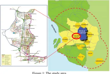
The Petaling Jaya (PJ) area was formerly known as the Petaling Jaya satellite town and has been upgraded into city status on June, 20, 2006 (figure 1). By year 2015, PJ had an estimation of becoming a sizeable town with the population estimated to 588,000 (table 1). Petaling Jaya has developed rapidly in tandem with the country’s growth and today it has become one of the nerve centers of the Malaysian economy. The administrative entity of Petaling Jaya is delineated by the Petaling Jaya City Council (MBPJ) boundary, covering an area of 97.2 sq km in 1997.
Figure 1: The study area
[image:3.595.127.508.87.343.2]The study area also covers by 6 out of 7 main gateways to the city center of PJ. Given to the current scenario and referring to the earlier study which found that about 92% of the whole study area has been developed and already saturated. Therefore the proper planning to the betterment of the public transport services is indeed crucial in order to overcome the current congestion issues and future scenario in this area.
Table 1: No. of population in MBPJ (projected until 2020)
Year No. of Population
2000 437,121
2005 474,800
2010 531,400
2015 588,000** (projected)
2020 644,600** (projected)
Source: MBPJ Local Plan, 2007 in Draft RKK-MBPJ 2010
The current scenario in major urban centers within the study area is not very different, but merely more complexes, particularly the saturation levels of the road system, the shortage of the parking spaces which results to the illegal parking scenario and the difficulty of managing them. Many of the centers within the study area are facing almost the similar problems mentioned above. From the earlier observation that been made found that, there are lot of parking spaces has been allocated by the city council, still it is not enough to cater for the growing number of vehicles into the city center. Many of them park their cars illegally on the street, making the congestion worst.
work opportunities in central areas, the shortages of parking spaces and poor control over irregular parking have boosted the problems caused by traffic congestion in central area.
Infra structure a nd utilities, 2%
Undeveloped La nd, 1% Forest, 0%
Wa ter Resource & Supply, 1%
Housing, 37%
Businesses a nd services, 9% Industry, 4%
Recrea tiona l a nd Unoccupied La nd
, 6% Institution & Community Fa cilities, 10%
[image:4.595.153.444.123.299.2]Tra nsporta tion , 30%
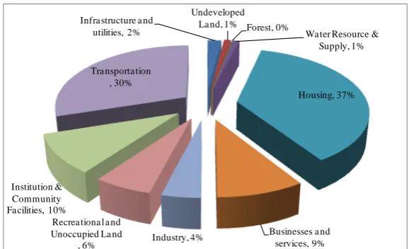
Figure 2: Current land use of the study area (SS Area)
3. TOD AND PARKING SYSTEM
3.1 Transit Oriented Development (TOD)
Transit Oriented Development (TOD) was introduced by Peter Calthorpe, a California planner and architect, in the late 1980s (Ian Carlton, 2009). He defined TOD as a mixed-use community within an average of 2,000-foot walking distance of a transit stop and a core commercial area. TOD is a mix of residential, retail, office, open space, and public uses in a walkable environment, making it convenient for residents and employees to travel by transit, bicycle, foot or car (Renne and Wells, 2002). Peter Calthorpe’s The Next American
Metropolis (1993) is the major work responsible for reintroducing TOD concept to the
planning and development professions (Renne and Wells, 2002). Calthorpe believed that by combining local pedestrian environment with access to regional centers by transit would reduce the number of private vehicle dependency as well as promoting more environmental friendly and sociable lifestyles. The social equity as one of the component in this kind of development would provide a greater variety of housing types at different range of costs and allow access to jobs without the expense of owning and maintaining a car.
The concept of livable city, which was raised out by Congressman Earl Blumenauer, during the Rail-Volution conference has attracted over a thousand participants to Washington to discuss various aspects of ‘building livable communities with transit’ (Renne and Wells, 2002).
TOD potential has been explained by factors such as system design and sitting, development control issues and public finance (Loukaitou-Sideris and Banerjee 2000; Boarnet and Crane 1998; Wilson and Anderson 1993 in Wilson, R (2005). Transport and the built environment are mutually dependent entities that have consistently pushed and pulled to create urban forms.
The movement toward TOD is in response to the increasing number of traffic congestion, advanced urban sprawl, affordable housing shortages, air pollution (Cervero et al. 2002) and a desire for a more pedestrian-friendly environment. Some components or themes of
transit-oriented design include:
• A mix of uses including office, residential, retail as well as public spaces around a key transit node (such as a train station).
• High quality design and increased density at and near train stations.
• Designs also promote and encourage the use of bicycles, rollerblades and walking as daily forms of transportation.
• Less parking options or managed parking to insure turn-over at transit nodes.
TOD offers significant opportunities to reduce the number of parking spaces below conventional parking requirements for retail, office and residential land uses. TOD provides these opportunities by increasing transit accessibility and combining a mixture of land uses (California Department of Transport, 2002).
3.2 Parking
Litman, T (2010) outlined that parking conflicts are among the most common issues face by the planners, operators, designers and other official. The problems generated by lacked of parking spaces are becoming more acute in many towns and cities, particularly in more densely area that are already trying to cope with inadequate public transport service and facilities. The scenario is even worse where the used of the existing areas is not undertaken on a well planned basis (Valleley, 1998) in Vianna et al. (2004).
On street parking, for example, is important in promoting the businesses in cities, especially within the central business district (CBD) area. On street parking provides an easy access to the businesses located in the city streets and occupies less land per space than off street parking which require access lanes in addition to parking space (Allison, 2002). On street parking tend to compete with other uses of roadway, including additional lanes for traffic flow, bike lanes and sidewalks. As drivers search for the availability of parking space, congestion on the roadways will increased. Axhausen et al. (1994) noted that looking for a space to park may take up to 40% of the total duration of a trip for certain group of drivers. Finally, the on street parking, like all forms of parking, attracts vehicles, in which will generates more traffic. In fact, for large cities trying to increase the number of transit ridership, availability and pricing of on street parking become a critical tools (Allison, 2002).
Shoup (2004) points out that the cost of parking is much higher than many people believed. He argues that parking should be charged and by not doing this, most cars are parked for excessively long times leading to insufficient parking space. Earlier in his study, Shoup et al.
(1997) have made other arguments for bringing the basic concept of supply and demand of parking. The costs of parking are high as they include the costs for purchasing the properties such as building and land as well as maintaining the facilities. Other numerous opportunity costs associated with parking such as additional lanes for traffic flow and sidewalks for on-street parking or for building other types of facilities or providing open spaces for off-on-street parking.
Allison, (2002) further pointed out that parking demand varies from one location to another, and there are many factors important in determining exactly how much parking is needed (e.g., type and intensity of land use, location, accessibility, availability of alternate modes of transportation) so minimum parking requirements are not easily transferable from lone locale to another.
Allison, (2002) reiterated that in terms of policies and management practices affecting parking lead to the outcomes that, in turn, can affect land use, air quality, traffic congestion, travel behavior, safety, and economic development, not to mention revenue lines. For example, policies that provide large amounts of un-priced parking may encourage automobile use and thereby increased the congestion level.
Decision on how to manage parking can exert tremendous influence on a number of other areas. For example, a study carried out by Ben et al. (2000), identifies three direct effects that parking has on the urban development i.e. (i) changes in the provision of parking and its costs affect the overall cost of travel, (ii) changes in parking can alter urban density levels since parking requires land that could otherwise be used for residential and commercial buildings, and (iii) parking can directly generate revenue as an economic activity.
However, building and maintaining parking is an expensive proposition. For example, on average, constructing and maintaining parking space over its lifetime costs about $25,000 but the costs can fluctuate depending on the jurisdiction. Municipalities that are proactive in reducing the number of parking spaces in favor of transportation demand management (TDM) measures can reduce these costs as well as gain a number of other related benefits (Transport Canada, 2010). Alternatively, some communities are replacing their existing parking spaces with bicycle racks, providing greater choice for commuter and recreational cyclists and potentially reducing the number of cars on the roads.
Kodama et al. in Boroski, et al. (2002) identified that, if the design and location of TODs enables a reduction in the number of parking spaces needed, the cost savings can be significant. This statement shared by Transport Canada (2010) which outlined several benefits that will be gained through the parking control or reducing parking spaces within the TOD area, such as:
(a) In terms of land use, especially in the center of business district (CBD) where the space is at premium. The city council can make better use of the land.
(c) Developers will benefits by freeing up the proposed parking space for other building uses and thus, lower their construction and maintenance costs.
(d) Increasing the number of pedestrian and cyclist will enhance economic opportunities for businesses.
(e) Encourage people to rely more on public transport, increase walking and cycling in which can turn the roads into safer place, reduce the greenhouse gas emissions and ease traffic congestion.
(f) By reducing the amount of paved area will lead to more environmental effects such as less storm-water runoff and reducing the urban heat effect.
4. STUDY METHODOLOGY AND OBJECTIVES
The field survey was conducted by observing the selected study area for the period of 10 hours maximum. The observation started from 8.00 am (am peak hour) until 6.00 pm (pm peak hour) during the weekdays. The study survey mainly focused on the hours of the parking spaces being occupied by the respective vehicles. The main objective of this preliminary study is to identify the parking problem(s) and whether the parking control system can be potentially implemented within the study area. Other objectives will be to identify the problems associated to the parking system and propose suitable measures to overcome the parking problems with the introduction of Transit Oriented Development (TOD) area.
5. PARKING SUPPLY AND POLICY
[image:7.595.106.490.475.694.2]The current parking services of the selected study area are mostly been awarded to the private company i.e. Godell Parking Sdn Bhd (table 2).
Table 2: Number of existing on street parking in SS Area
No. Areas No. of Parking Remarks
1 SS2 2,127
Privatise to Godell Parking Sdn Bhd
2 SS3 541
3 SS4 316
4 SS5 349
5 SS6 633
6 SS7 212
7 SS9 112
8 SS20 397
9 SS21 1,758
10 SS22 1,012
11 SS23 408
12 SS24 505
13 SS25 906
14 SS26 812
Total 10,088
Source: Petaling Jaya City Council (MBPJ) 2010
pm from Monday to Friday, whereas Saturday, Sunday and public holiday, are free parking day. The City Council also provided reserved parking at the monthly rate of RM400.00 for 1 space (front-side) and RM300.00 (rear-side). Application on this type of parking can be made through the city council where the payment needs to be settled upon. Table 2 below outlined the list of number of parking for the study area:
6. FINDINGS OF THE STUDY
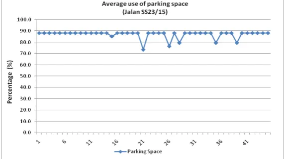
This preliminary survey study identified that 30% of the cars’ owner provided 8 hours parking (long term parking), whereas 43% of them provided more than 5 hours parking (Figure 3). Much of it, i.e. 92% of the parking spaces in this study area are almost fully occupied during the day time (Figure 4). The strategic location of this study area which includes of offices (government and private), market, shop and residential should be able to accommodate the used for an average parking of 1 to 2 hours for any businesses purposes. This area has been identified as one of the high density area with the number of double or triple parking which exists during the day time. Moreover, the study found that within every 15 minutes almost 100 percent of the parking spaces are fully occupied. The scenario is worsening by the existing of illegal parking within the clamping area. This situation therefore portrayed the existing situation within the daily activities of the area where this study has identified as one of the hot spot area for traffic.
[image:8.595.154.444.556.716.2]Figure 3: Average hourly parking used in a day (Jalan SS23/15)
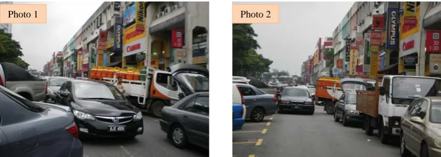
Photo 1 and 2: View of double on-street parking at Damansara Utama (Up-town) during day time
Photo 3 and 4: View of illegal parking (within clamping area) at Damansara Utama (up-town) during day time.
[image:9.595.74.522.82.242.2]Parking is one of the hotly contested issues within the study area, especially at Damansara Utama (up-town) (refer Photo 1 to 4). In terms of land use, this area has been identified as one of the area which undergone the urban gentrification process i.e. changing of land use in terms of housing area to business and services. This process thus would bring some changing in terms of traffic flow into the area, as been predicted by using traffic model calibration process (table 3).
Table 3: Future traffic growth of the study area
Year Natural Development Growth (%)
2010-2015 4.0
2016-2020 3.0
2021-2025 2.0
2026-2030 1.0
Source: Draft RKK-MBPJ 2010
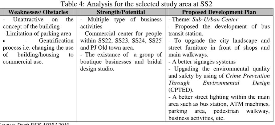
A part of the SWOT analysis has been used to identified the strength and weaknesses of the development plan for the selected study area i.e. SS2 (Damansara Utama is one of the centers within this area) (table 4).
Photo 1 Photo 2
Table 4: Analysis for the selected study area at SS2
Weaknesses/ Obstacles Strength/Potential Proposed Development Plan - Unattractive on the
concept of the building - Limitation of parking area • - Gentrification process i.e. changing the use of building/housing to commercial use.
- Multiple type of business activities
- Commercial center for people within SS22, SS23, SS24, SS25 and PJ Old town area.
- The existance of a group of boutique businesses and bridal design studio.
- Theme: Sub-Urban Center
- Proposed the development of bus transit station.
- To upgrade the city landscape and street furniture in front of shops and main walkways.
- A better signages systems
- Upgading the environmental quality and safety by using of Crime Prevention Through Environmental Design (CPTED).
- A better street lighting within the main area such as bus station, ATM machines, parking area, pedestrian walkway, business activities, etc.
Source: Draft RKK-MBPJ 2010
7. FACTORS DRIVING TOWARDS PARKING MANAGEMENT CONTROL AND TOD
Given the current scenario of the parking issue within the study area, the problem of long term parking would make the situation worst. However, this study did not cover the issue of whether the parked cars’ belongs to the shop owners and employees. The important issue here is that the need to overcome the long term parking, in giving the other car users opportunities to park their car in upon finishing their businesses within the area.
As been stated earlier that parking space is not necessarily to be in the proposed TOD area, but the location can be near to it. The study area also has been identified as one of the area that are currently undergone the gentrification process, therefore the need to consider the new paradigm of managing or providing parking within the area. Table 5 below outlined several issues considering in shifting the paradigm of parking policy.
Table 5: Paradigm shift in parking policy
Issues Old Paradigm New Paradigm
Parking considered as Public good Commodity
Demand assumed Fixed/elastic Flexible / elastic
Supply should Always grow Be managed in response to demand Government regulations Set minimums and no standard None / set maximums
Pricing maximises Utilisation Availability
Turnover encouraged via Time limits Pricing
Costs should be Bundled with goods Transparent to users
Source
The linked between TOD and parking is significant as TOD offers opportunities to reduce the number of parking spaces below conventional (old paradigm) parking requirements for retail, office and residential land uses. TOD provides these opportunities by increasing transit accessibility and combining a mixture of land uses (Boroski et al. 2002).
more development to be built on sites near transit. However, there is no single formula that can or should always be used, and parking needs can vary widely in various locations, even within the same jurisdiction.
[image:11.595.65.534.245.464.2]Litman (2010), reiterated that, in an attempt to reduce or remove the number of parking, or implement a new parking program/policy, municipality should be willing to offer stakeholders a variety of options such as the introduction of short, medium and long term planning such as regular parking price hikes or introducing new transit services. Dittmar and Ohland (2004) also suggested that part of the fees charging for parking can be used to finance other public transport supporting system such as the bicycle lanes, pedestrian walkways, etc.
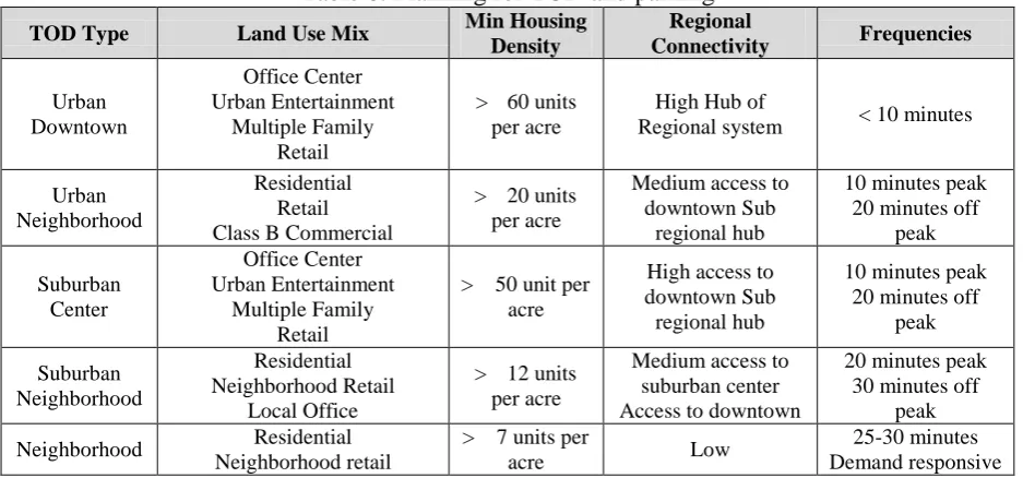
Table 6: Planning for TOD and parking
TOD Type Land Use Mix Min Housing
Density
Regional
Connectivity Frequencies
Urban Downtown Office Center Urban Entertainment Multiple Family Retail
> 60 units per acre
High Hub of
Regional system < 10 minutes
Urban Neighborhood
Residential Retail Class B Commercial
> 20 units per acre
Medium access to downtown Sub
regional hub
10 minutes peak 20 minutes off
peak Suburban Center Office Center Urban Entertainment Multiple Family Retail
> 50 unit per acre
High access to downtown Sub regional hub
10 minutes peak 20 minutes off
peak Suburban Neighborhood Residential Neighborhood Retail Local Office
> 12 units per acre
Medium access to suburban center Access to downtown
20 minutes peak 30 minutes off
peak
Neighborhood Residential Neighborhood retail
> 7 units per
acre Low
25-30 minutes Demand responsive
Source: Dittmar and Ohland, 2004 in TCRP Report 128
8. PLANNING FOR PARKING MANAGEMENT CONTROL SYSTEM
An area which attempt to combat sprawl and built more compact as well as mixed use communities find that parking supply is a crucial variable. Within such areas, policies may be designed to limit the on street parking ratios in which may require structured parking only or severely limit surface parking, may insist on providing a pivotal share of the parking supply through publicly owned and managed facilities, or may arrange for sites with different temporal needs for parking such as office building and apartments to share parking in the same facility (TCRP Report 95, 2003). In turn, an area where parking is to be restricted will certainly find environmentally sound implementation aided by provision and enhancement of other travel alternatives as well as application of well planned pedestrian and transit friendly land use.
However, planning for parking within the study area should also consider the following statement by ULI; Dittmar & Ohland (2007) i.e. if there is too much parking provided, opportunities to create a vibrant pedestrian friendly environment are considerably reduced, whereas if too little parking is provided, the surrounding area businesses and neighborhood could become negatively impacted by transit users’ parking in spaces meant for customers and residents.
Managing on-street parking intelligently is essential to liveable and vital neighborhood commercial streets. Sound parking management makes the short-stay, high turnover parking that merchants need available at the times they need it most. Good parking management reduces traffic generated by drivers cruising for parking spots. Good parking management generates more money from meter fees than from fines. Good parking management encourages office commuters to use transit, and encourages long-stay parkers to park off-street, leaving convenient on-street parking for shoppers, diners, and theater and movie goers. Good parking management discourages overflow parking into adjacent residential neighborhoods.
Therefore, ULI has suggested four ‘principal tools’ as part of providing flexible parking standards:
(i) Move it – the location of parking is within 5 – 7 minutes walking from/to station platform.
Alternatively, as part of the components for TODs, regardless of size, parking should be located behind the buildings including the alternative parking solutions such as shared parking and lower parking to occupancy ratios and increased in bicycle parking. Providing sufficient park and ride facilities for commuters will help to avoid significant parking impacts on new and existing development. The location of vehicle parking is essential in meeting the goals of a pedestrian-friendly, transit-supported public realm.
On the other hand, parking can be located near, but not at the transit facility. This strategy is to avoid congestion and encourage drivers to patronize local shopping and services. At the very least, parking structures could also be designed to enhance pedestrian experience by including retail or other visually appealing uses at the street level.
(ii) Share it – designing of parking lots and garages to serve multiples users based on time-of-day and time-of-week use, for example commuter patrons’ use the parking facilities during the weekdays and recreational patrons use them during weekends. The share parking tool is one of the most promising tools to reduce aggregate parking levels in TODs. For example, the developers of Reston, Virginia were allowed to reduce parking in the downtown core by 25% because of efficiencies anticipated through required shared parking. Another example is at the Mockingbird Station, Dallas Texas where the developer has been allowed to reduce total parking up to 27% for the same reason (California Department of Transport, 2002).
(iii) Deck it – provide multiple floor parking structures rather than surface parking lots. This is due to high costs per parking space for these types of parking structures and a higher fee should be charge.
However, caution should be put that reduced parking ratios should not be adopted without analyzing the specific character and the needs of the development area (TCRP Report 95, 2003). Listed below are several of the questions that need attention, especially to the local authority concern:
o Are parking requirements reduced in close proximity to transit, compared to the norm?
o Is structured parking encouraged rather than surface lots in higher density areas?
o Is most of the parking located to the side or to the rear of the buildings?
o Are street patterns based on a grid/interconnected system that simplifies access?
o Are pedestrian routes buffered from fast moving traffic and expanses of parking?
o Are there any convenient crosswalks to other uses on and off site?
o Can residents and employee safely walk or cycle to the nearest store, post office, bank, etc?
o Does the site’s street pattern connect with street in adjacent development?
On the other hand, in order to reduce the number of long term parking, the existing parking fare within the study area is proposed to be increased to RM30 – RM50/day or planning for regular parking hikes especially within CBD area. In addition to that, the seasonal parking area should be abolished since there are quite number of the space accommodate for it are left empty especially during peak hour, where the number of people searching for parking is alarming and it has resulted in illegal parking within the study area. As for the on-street parking, it has been proposed that only the short term parking is allowed in the CBD area where most of the parkers doing their business or activities for one hour or two, at most. This is to avoid long terms parkers to utilise those parking lots. The using of intelligent ticket machine in identifying and avoiding of issuing the same plat number for the second time is desireable.
9. CONCLUDING REMARKS
The study shows that parking can successfully be reduced in TOD. However, there is no single formula that can or should always be used, and parking needs can vary widely in various locations - even within the same jurisdiction (Boroski et al. 2002).
As been discussed above, the study area needs some development in terms of re-development with regards to land use and re-development around the proposed TOD area i.e. within 400 meters radius from the center point of the transit station. Justifications for re-development of the study area are as follows:
- Introduction of the mix-development plan around the proposed TOD area. - Enable of the high development intensity for the TOD area.
- Re-development in which to encourage fully used of the public transport system. - To encourage walking and cycling within the TOD area, in which give the fully accessibility to the public transport users.
utilities (20%) and reserved for green area (10%). The development of the proposed TOD area is planned to be in 2 phases i.e. (i) Phase 1 (2011-2015) and (ii) Phase 2 (2016-2020).
As a conclusion and answering the question on whether the selected study area has the potential to be TOD, much need to be done beforehand especially on reliability of the public transport services, quality, frequency, convenience, comfort and accessibility, it certainly seems to be the case. Much of it, as part of the planning process, parking policy and management control can help the transformation process, mainly in associated to land use development of the surrounding areas of proposed TODs. Some other conclusion gathered from the study is that:
(a) Collaboration is the key elements to successfully build a TOD. This is part of public and private partnership (PPP) work which includes the different levels of governments and different agencies across government.
(b) Lack of public policies on the new paradigm of the way parking is to be managed especially within the study area.
(c) It is necessary to develop a system for classifying different places and creating guidelines for success. Future TODs should learn from the successes and/or failures of the past as it is necessary to define obstacles to success, especially in a local context.
(d) As part of the development plan, parking needs special attention from the authority in transforming PJ area into a liveable city and city for all.
REFERENCES
Allison L.C. de Cerreño (2002), The dynamics of on-street parking in large central cities, Rudin Center for Transportation Policy and Management, New York University Robert F. Wagner Graduate School of Public Service.
Anas, A. and Rhee, H.J (2005), Curbing excess sprawl with congestion tolls and urban
boundaries, Regional Science and Urban Economics.
Arrington, G.B and Cervero, R. (2008), Effects of TOD on housing, parking and travel. Transit Co-Operative Research Program (TCRP) Report 128, Transportation Research Board (TRB)
Ben et al. (2000), Parking restraint policy and urban vitality. David Simmonds Consultancy.
Cambridge, Engla in Transport Reviews Vol. 20 (2000): 291-316. Download date: 2010-09-01
Boroski et al. (2002), Special report parking and TOD: challenges and opportunity. Parsons & Brinckerhoff and the California Department of Transportation.
California Department of Transport (2002), Statewide TOD study factor for success in California special report parking and TOD: challenges and opportunities.
Dittmar, H. and Ohland, G. (2004), The new transit town: best-practices in transit
oriented development. Island Press, Washington D.C.
Ian Carlton (2009), Histories of transit oriented development: perspective on the development of the TOD concept. IURD Working Paper Series, Institute of Urban and Regional Development, UC Berkeley
Jamilah, M and Ibtishamiah, N.I. (2002) Characteristics of bus service provision in Kota Bharu, Kelantan, Malaysian Transport Research Forum Conference (MUTRFC), Universiti of Malaya, Kuala Lumpur.
Litman, T (2010) Parking management: strategies, evaluation and planning. Victoria Transport Policy Institute
Paul, B (2010) How ‘transit-oriented development’ will put more New Yorkers in cars.
Pijanowski et al.(2010), The environmental and economic costs of sprawling parking lots in the US. Land Use Policy Vol. 27 pp. 255-261
Porter, D. (1997), Transit focused development: a synthesis of practice. Washington, D.C.: Transportation Research Board, National Research Council.
Renne, J and Wells, J. (2002) State of the literature: transit-oriented development, Voorhees Transportation Policy Institute, Edward J. Bloustein School of Planning and Public Policy, Rutgers University
Shoup, (2004), The high cost of free parking, American Planning Association, APA Planners Press, Chicago
Shuop et al. (1997), The High Cost of Free Parking.” Journal of Planning Research Vol. 17, pp 3-20.
Transit Cooperative Research Program (TCRP) Report 95 (2003), Traveler response to transportation system changes – Chapter 18 Parking Management and Supply. Transportation Research Board (TRB) Washington DC
Transport Canada,
Urban Land Institute (ULI) and Dittmar & Ohland (2007), Ten principles for successful development around transit, An Issue Paper of the American Planning Association Hawaii Chapter.
Vianna, et al (2004), Intelligent Transportation Systems and Parking Management: Implementation Potential in a Brazilian City. Cities, Vol. 21, No. 2 pp 137-148. Elsevier
Wilson, R.W. (2005), Parking policy for transit oriented development: lesson for cities, Transit Agencies and Developers, Journal of Public Transportation Vol. 8 No. 5.
Wilson, R.W. (1992), Suburban parking economics and policy: case studies of office worksites in Southern California. Prepared for the Federal Transit Administration by California StatePolytechnic University. Washington, DC