Munich Personal RePEc Archive
Expert Systems and Artificial Neural
Networks for Spatial Analysis and
Modelling. Essential Components for
Knowledge-Based Geographical
Information Systems
Fischer, Manfred M.
Vienna University of Economics and Business
1992
Online at
https://mpra.ub.uni-muenchen.de/77818/
lnstitut fur Wirtschafts- und Sozialgeographie
Wirtschaftsuniversitat Wien ,
Vorstand: o.Univ.Prof. Dr. Manfred M. Fischer A - 1090 Wien, Augasse 2-6, Tel. (0222) 313 36 - 4836
WSG 17/92
Expert Systems and Artificial Neural Networks for Spatial Analysis and Modelling:
Essential Components for Knowledge-Based Geographical Information Systems
Manfred M. Fischer
WSG-Discussion Paper 17
lnstitut fur Wirtschafts- und Sozialgeographie
Wirtschaftsuniversitat Wien
Vorstand: o.Univ.Prof. Dr. Manfred M. Fischer A - 1090 Wien, Augasse 2-6, Tel. (0222) 313 36 - 4836
WSG 17/92
Expert Systems and Artificial Neural Networks for Spatial Analysis and Modelling:
Essential Components for Knowledge-Based Geographical Information Systems
Manfred M. Fischer
WSG-Discussion Paper 17
1. Introduction
Current geographical information systems (GIS) are capable of acquiring spatially indexed data (locational, temporal and attribute information) from a variety of sources; changing the data into useful formats; storing the data; retrieving and manipulating the data for analysis; and then generating the outputs required by a given user. Their great strength is based on the ability to handle large, multilayered, heterogenous databases of spatially referenced data and to query such databases about the existence, location and properties of a wide range of spatial objects in an interactive way.
But the current systems have only limited analytical functionality for analysing spatial data. The data manipulation procedures usually included in standard geographic information systems are limited to Boolean operations on the attributes of spatial entities (points, lines, polygons; measurements of distance and direction; geometrical operations such as rotation, translation and scaling of coordinates, rectification and removal of distortion, etc.), to line intersection, point-in-polygon or polygon overlay in raster or vector mode, to the creation of buffer zones around a feature, simplified forms of network analysis, and the computation of various simple statistics on the attributes of the entities. Much of the built-in analytical functionality in commercial GIS reflects the perceived needs of the current GIS market. But it is becoming increasingly evident that the standard analysis options are insufficient for scholars working in various fields (Burrough 1990).
The last few years have witnessed significant advances in the field of artificial intelligence (Al) leading to the emergence of practical and useful artificial intelligence technologies. Not all technologies and concepts will be useful in a GIS world, but some - especially artificial neural networks and (rule-based) expert systems - have the potential to be essential to the development of a new generation of intelligent or knowledge based geographic information systems. The following discussion places more emphasis on artificial neural networks than on expert systems due to two reasons. First, artificial neural networks or neurocomputing may be considered to have a much farer reaching potential to meet the needs for analysis and modelling generated by the GIS-revolution. Second, up to now geographers and regional scientists - with the exception of very few scholars like Openshaw (1992a, b), Halmari and Lundberg (1991 ), White (1989) - have been rather slow in realising the revolutionary potential of artificial neural networks for spatial analysis and modelling in a GIS-world.
The paper is structured as follows. Section 2 briefly points to three major deficiencies of current geographic information systems: the logical foundation based on the classical concept of Boolean logic and classical set theory; the limited analytical functionality; and the low level of intelligence in terms of knowledge representation. The removal of these deficiencies is considered to be essential for the next generation of geographic information systems, the knowledge-based systems. Rule-based expert systems and artificial neural networks for spatial analysis and modelling are believed to be major components in such systems. Section 3 briefly summarizes the expert system approach, while in sections 4 and 5 emphasis is laid on neurocomputing. Section 4 describes some basic characteristics and principles of neurocomputing necessary to understand the applications potential of artificial neural networks to be discussed in section 5.
2. Some Major Limitations of Current Geographic Information Systems and the Need for a Knowledge Orientation
A geographical information system (GIS) may be defined as a computer based information system which attempts to capture, store, manipulate and display spatially referenced data (in different points in time), for solving complex research, planning and management problems. The system may be viewed to embody
• a database of spatially referenced data consisting of locational and associated attribute data, (large-scale) data sets where the data included usually have spatial characteristics such as spatial (space-time) dependencies, stationarity, varying degrees of reliability, multivariate normality, non-linearities, sensitivity to scale and aggregation effects, noise because of error propagation or due to the nature of data sources (see Openshaw et al. 1990, Openshaw 1992b),
• appropriate software components encompassing procedures for the interrelated transactions from input via storage and retrieval, and the adhering manipulation and spatial analysis facilities to output, and
• associated hardware components including high-resolution graphic display, large-capacity electronic storage devices and processing units
which are organized and interfaced in an efficient and effective manner to allow rapid data storage, retrieval and management capabilities and to facilitate the analysis.
Current geographic information systems suffer from three major limitations (see Clarke 1990, Goodchild 1991. Fischer and Nijkamp 1992, Leung 1992):
• The first major deficiency is caused by the logical foundation. Geographic information systems are predominantly based on the classical concept of Boolean logic and classical set theory which do not tolerate imprecision in information, human cognition, perception and thought processes. Boolean logic imposes artificial precision on intrinsically imprecise spatial data, phenomena and processes. It is inadequate to handle imprecision of information and knowledge in the representation of spatial data and relationships, in the query and analysis of spatial information. This limitation calls for a more general and sound logical foundation of geographic information systems as offered by the concept of fuzzy logic (see Leung 1992).
GIS-relevant spatial procedures and techniques which might be taken into consideration to increase the analytic and modelling functionality of geographic information systems, including inter alia exploratory spatial pattern analysis, regional taxonomic procedures, spatial interaction and choice models, spatial regression models with spatially autocorrelated errors, location-allocation models, space-time statistical models (see Openshaw 1990, Goodchild 1991, Fischer and Nijkamp 1992).
• The third major deficiency of the systems refers to the low level of i nte 11 i gence in terms of knowledge representation and processing. Geographical problems are highly complex in nature. Effective solutions of such problem_s require an intelligent use of large data bases, structured and unstructured (procedural) knowledge. Over the years, structured (procedural) knowledge taking the format of statistical and mathematical models has been developed in Quantitative and Theoretical Geography, and recently loosely coupled with conventional geographic information systems via data export and import (see Leung 1992). The application of new artificial intelligence principles and technologies in general, and expert systems and artificial neural networks in particular, provides the potential to increase the level of intelligence of geographic information systems.
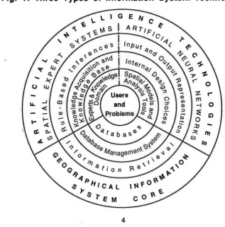
Fig. 1: Three Types of Information System Technology
[image:8.595.124.442.473.795.2]Combining different types of information system technologies (such as GIS, expert systems and artificial neural networks) can help to reduce the limitation of each system, and in particular to increase the level of intelligence of geographic information systems (see Fig. 1 ).
The deficiencies of conventional geographic information systems mentioned above point to three elements which have to be considered to be critical for integration into the next generation of more intelligent systems:
• the concept of fuzzy logic,
• advanced spatial analysis and models modules via conventional tools and/or via • artificial intelligence technology in general and spatial expert systems (SES) and
artificial neural networks (ANN) in particular.
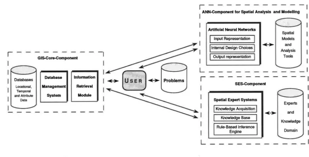
Fig. 2 outlines a system architecture of a knowledge based geographic information system which takes these elements into account and, thus, would greatly enhance the power and usefulness of geographic information systems for spatial analysis and decision making in such a way that the GIS can offer intelligent advice or take an intelligent decision about geoprocessing functions. The architecture is based upon three major components:
• the GIS core component includes the databases (locational, temporal and attribute data), a database management system(s) and an information retrieval module,
• the spatial expert system (SES) component for clearly defined and relatively simple spatial analysis and modelling tasks, with a knowledge-acquisition module, a (spatial and non-spatial) domain-specific knowledge base and a rule-based inference engine,
• the artificial neural networks (ANN) component for more sophisticated forms of spatial analysis and modelling.
I
O>
Databases
Locational, Temporal
[image:10.845.96.715.156.470.2]and Attribute Data
Fig. 2: System Architecture of a Knowledge-Based Geographic Information System
GIS.Core-Component
-,
Database
11
lnfonnation Management RetrievalSystem I I Module
,---,
I ANN-Component for Spatial Analysis and Modelling
L
r
L
Artlflcial Neural Networks
I
Input Representation jj
1nternal Design Choices jI
Output representationI
Spatial Models
~1 and
Analysis Tools
SES-Component
Spatial Expert Systems
I
Knowledge AcquisitionI
I
Knowledge BaseI
Rule-Based inference Engine
~
Experts
and
Knowledge
via the artificial neural network component and declarative (rule-based) knowledge basically via the expert system component.
To account for imprecision in spatial data as well in the reasoning process fuzzy logic extending the operations of Boolean algebra to cover fractional truth-values intermediate between 0 (false) and 1 (true) may be employed as the logic foundation in the design of the system (see Leung 1992, Wang et al. 1990). This implies the integration of a fuzzy relational data model, a fuzzy information retrieval tool and fuzzy-logic-based expert systems. Both, the artificial neural network and the expert system modules are coupled with the GIS-environment. User interfaces may facilitate communication with the GIS environment, the expert systems and the building of spatial model and analysis based art!ficial neural networks.
This system architecture would enable to link spatial analysis and modelling with GIS intelligently for specific domains, via the SES- the ANN-components, and would assist the user to choose the best set of procedures and tools to solve his problem at hand within the constraints of data, data quality, cost and accuracy. The neural network and the expert system components fundamentally differ in their knowledge representation techniques. Expert systems utilize the way of symbolic encoding of knowledge in form of production rules (forward/backward chaining systems), the mainstream approach to knowledge representation, while artificial neural networks commited to the principle of interconnectivity represent knowledge implicitly rather than explicitly.
3. The Expert System Component
Expert systems may be viewed as systems which achieve expert-level performance utilising symbolic representation of knowledge, inference and heuristic search. They are designed to provide acceptable solutions using knowledge from experts and emphasize domain-specific knowledge rather than more general problem solving strategies. Four kinds of software tools are available for developing expert systems:
• conventional languages such as C-language, • Al languages such as Lisp and Prolog,
• Al development environments such as KEE (Knowledge Engineering Environ-ment, lntillcorp.).
Expert system shells and Al development environments greatly reduce the cost of developing expert systems.
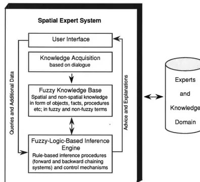
Spatial expert systems, i.e. expert systems with a spatial domain, have evolved via a manner which parallels that of expert systems in the business data processing community (see, for example, Smith et al. 1987, Kim et al. 1990). A fully fledged fuzzy-logic-based expert system consists of four essential components (see Fig. 3)
• a knowledge acquisition module to assist in expressing knowledge in a form suitable for inclusion in the knowledge base,
• a fuzzy knowledge base consisting of spatial and non-spatial knowledge in fuzzy and non-fuzzy terms ((spatial) objects and their attributes, relationships and their attributes, etc.) about some substantive domain,
• a fuzzy-logic-based inference engine consisting of rule-based inference procedures and control mechanisms used to detect, select, and execute relevant rules in the knowledge base,
• an user interface which assists the user to consult the spatial expert system.
In fuzzy-logic based expert systems fuzzy logic is employed to handle appropriate reasoning so that fuzzy and non-fuzzy terms can be employed to make inferences.
The user interface is a general module which controls 1-0-behaviour of the system and facilitates user interaction with the system. The interface fulfills basically two functions: first, to provide the user with the information required to solve his problem, to display the conclusions and to explain its reasoning; second, to translate queries from the user into specific goals for the expert system's engine machine.
The knowledge acquisition module serves to interact with the domain's expert to acquire information relevant to both the knowledge domain and judgemental behaviour of the expert, in terms of objects, facts, fuzzy terms etc. The conventional approach in knowledge acquisition is interview-based [and by static analysis].
Interviewing is essential in eliciting new knowledge from domain experts. The purpose of an interview is to acquire knowledge useful in problem solving. The fundamental challenge is to decide what kind of knowledge to ask for in what situations. Major recent efforts are directed towards computer-based acquisition systems which, however, suffer from the so-called knowledge-acquisition dilemma (see Kawaguchi et al. 1991 ). If the system is ignorant, it cannot raise good questions, and if it is sufficiently knowledgeable, it must not raise questions. Consequently, special attention is being paid to identifying what knowledge to give a system in advance and how to use that advanced knowledge to facilitate knowledge acquisition.
Fig. 3: The Expert System Component of a Knowledge Based Geographic Information System
Spatial Expert System
User Interface
Knowledge Acquisition
based on dialogue
ra
y
1a (/)
0 c: 0 Experts
cu
c: ~Fuzzy Knowledge Base c:
.Q ra and
;t:::
Spatial and non-spatial knowledge
a.
<>
"O x
~ in form of objects, facts, procedures w
"O Knowledge "O c: etc; in fuzzy and non-fuzzy terms c:
ra
ra Q)
(/) 0
Q) ·::;
Domain ·c: Q) ~ :J a
Fuzzy-Logic-Based Inference Engine
[image:13.595.108.505.338.699.2]The knowledge base is elicitated from a domain expert and reformulated as a collection of rules or a frame-based structure. Rules derived from experts may be inexact, measurements unreliable, etc. This is especially true in complex spatial tasks and demands for a fuzzy, rather than a precise knowledge base. The production rules format of the general forms of if [conditions} I then [actions}.
The inference engine consists of search and reasoning procedures which enable an expert system to arrive at conclusions. The choice of an inference strategy and the choice of knowledge representation are inextricably bound together. In the rule-based systems it is common practice to employ all or some of the following reasoning strategies: backward chaining, forward chaining and/or Bayesian inference (see Graham 1989). Rule-based reasoning, however, limits a system's ability to acquire knowledge from domain experts. One of the solutions to the knowledge-acquisition problem is to reduce dependency on domain experts as much as possible. Several alternatives, such as model-based reasoning, case-based reasoning, and explanation-case-based learning have been analysed. Model-based reasoning utilizes a domain model of structural and functional knowledge about a given target system. It can deal with new situations which rule-based reasoning cannot cover, but its major drawback is the amount of the measuring or testing it must perform to find solutions. Case-based reasoning utilizes past problem-solving cases, including success and failure stories which directly reflect domain experts' experience. Finally, explanation-based learning, a deductive learning procedure, is a framework of generating compiled knowledge from goal concepts, training examples, domain theory and operationality criteria (see Kobayashi and Nakamura 1991 ).
The advantages gained by the integration of an expert system into a GIS world are basically derived from the qualities of the rule-based languages (such as Prolog) (see Webster 1990):
• symbols representing ideas, expectations, adjectives as well as numerical data can be subjected to the same general inferential processing, the semantic flexibility makes rule-based data processing of interest in the search for more semantically-oriented database models,
• the ability to integrate database operations with processing rules implying efficient data processing,
• the ease with which programs and knowledge bases can be amended via ad hoc modifying a set of processing rules,
• the new level of flexibility gained when facing the question of how much information to codify in explicit data representation and how much to leave for deriving via processing rules.
Up to now, however, there are only a few applications of expert systems in spatial analysis and search (see Smith et al. 1987, Kim et al. 1990, Webster 1990, Leung 1992). Compared to other disciplines, research on expert system application has lagged in geography and regional science, due to several reasons. One fundamental reason might be disparities between the type of problems geographers and regional scientists are usually dealing with and the type of problems for which the approach of expert systems is suited. Experience with rule-based expert systems shows that the set of rules required to accomplish multidimensional and complex tasks characteristic to the GIS world is often quite large.
In addition, developing rules and related heuristics may be extremely time consuming and only feasible for relatively simple, well-bounded problem situations in which clear diagnostic rules and procedures are known a priori. The major problem domains of GIS and spatial analysis in which expert systems can be applied include:
• automated map design which emulates an expert cartographer in the task of locating feature names on a map using a heuristic graph-searching algorithm,
• automated device routines for extracting, sorting, describing data and object structure (for example, a feature extraction detecting valleys and streams using the procedural knowledge in the knowledge base),
• coupling expert systems and specific spatial analysis and model tools to provide qualitative reasoning capability (translation of qualitative criteria into numeric input and translation of the output to qualitative concepts) and more intelligent interfaces to the user.
problems), input necessary parameters and interpret spatial analysis outputs. In addition, expert systems might be used to enable uncertainty reasoning and to resolve inconsistent and contradictionary information obtained in GIS databases. Among the problems of coupling expert systems with GIS the limited capabilities of current expert system shells and the lack of formalism typical for many problem areas in geography and regional science have to be mentioned.
4. The Artificial Neural Network Component
Artificial neural networks (neurocomputing) are generating much interest among engineers and academic scholars in different fields. They owe their current popularity to two major sources: first, significant major breakthroughs in the design and application of neural networks in the 1980s; second, the new technologies such as optical processing of information, high-density semiconductor networks, and eventually new materials like the 'spin-glasses' which offer an unforeseen capacity for computation.
Artificial neural networks inspired by models of the human brain and nerve cells -may be viewed as structured networks of highly interconnected processing units or processors (often also termed neurons, in analogy to biological neural networks) with modifiable interconnection weights (Baldi and Hornik 1989). They have the ability to learn a desired mathematical or statistical function of any complexity from training samples and to generalise as well as to abstract essential characteristics from data inputs.
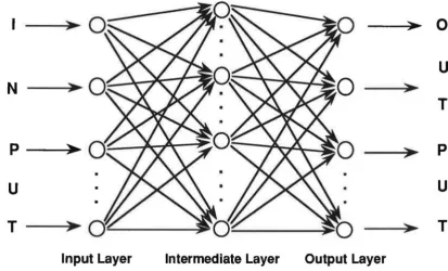
Typically, the processing elements are organised into a hierarchical series of levels (layers): an input layer, one or more intermediate (so-called hidden) layer(s), and an output layer. Fig. 4 shows a neural network with three layers of processing units, a typical organisation for the popular neural network architecture which is known as back-error-propagation. The processing elements of the input layer assume the values of an input pattern represented as a vector which is input to the network. The intermediate layer consists of processing elements which receive and transmit the input signals. Sometimes, there is more than one intermediate layer. These intermediate layer processors are connected to output neurons which form the output layer. Note that connection within a layer or from higher to lower layers are forbidden. But connections can skip intermediate layers.
Fig. 4: An Artificial Neural Network with Three Fully Interconnected Layers
>
0
u
N
>
T
p
>-
:>
p
u
u
T
>
>
T
Input Layer Intermediate Layer Output Layer
Each interconnection between processing elements acts as a communication route . Numeric values are passed along these interconnections from one processor to another. They are weighted by connection strengths which are associated with each interconnection and adjusted during training to generate the final neural network.
Fig. 5 depicts an example of a typical processing unit i in layer k of a multilayered network. On the left side there are the multiple inputs to the processor. The output connections are shown at the right. The same output value is sent along all the output connections. A processing unit acts as some kind of nonlinear leaky integrator of input. The total input Ii of the units j that are connected to the unit i is
generally appoximated by a linear function
(1)
where ~i denotes the activation level (output value) of unit j connected to i and µii
[image:17.598.87.501.127.377.2]input to each unit which always has a value of one. The weight on this extra input is called the bias and is equivalent to a quenching threshold of the opposite sign. It can be treated just like the other weights.
Non-linear processing units i yield continuous-valued non-negative outputs 'lli
which are typically approximated by a non-linear function of its total input as follows
11; =
1 / (
1+
exp ( -~ ~i ~
) )(2)
Any continuous-valued non-negative input-output function which has a bounded derivative may used. But the use of a linear function (1) for the integration of the inputs to a unit before applying the non-linearity greatly simplifies the learning procedure. All units within a layer have their states (activation levels) set in parallel,.but different layers have their states set sequentially, starting with the input level and moving forward until the states of the output units are determined (see Rummelhart et al. 1986).
Fig. 5: Basic Processing Unit from a Layered Artificial Neural Network
Input Connections with Corresponding
Q
Weights0-
~
---.:..µ_i2--..)i,..0
Output Connections with Corresponding
Weights
Q
0
Input to Unit IProcessing Units j
in Layer k-1 with Activation Level ~i
Processing Unit
in Layer k with
Activation Level 'lli
Output of Unit I
distributed to Processing
Units 1 , ... , I in Layer k+ 1
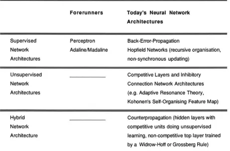
[image:18.598.125.480.454.727.2]Most neural networks undergo a training procedure during which the interconnection parameters are adjusted to ensure that for each input vector the output vector generated by the network is sufficiently close to the desired output vector. Training may be supervised or unsupervised. The most important examples of supervised and unsupervised neural network architectures are outlined in Table 1. Back-error propagation is the most widely used of the neural network architectures. Such networks are supervised and usually layered, with each layer (fully) connected to the layers below and above. Back-error propagation is an important step forward compared to its forerunner, the perceptron, which was limited to only two layers of processors, with only a single layer of adaptable weights (see Rosenblatt 1958). The power of the back-error propagation network architecture lies in its ability to train hidden layers and, thus, to escape the restricted capabilities of single-layered networks as in the case of the Hopfield networks (see Dayhoff 1990).
Table 1: The Most Important Examples of Supervised and Non-Supervised Neural Network Architectures
Supervised
Network
Architectures
Unsupervised
Network
Architectures
Hybrid
Network
Architecture
Forerunners
Perceptron
Adaline/Madaline
Today's Neural Network Architectures
Back-Error-Propagation
Hopfield Networks (recursive organisation,
non-synchronous updating)
Competitive Layers and Inhibitory
Connection Network Architectures
(e.g. Adaptive Resonance Theory,
Kohonen's Self-Organising Feature Map)
Counterpropagation (hidden layers with
competitive units doing unsupervised
learning, non-competitive top layer trained
[image:19.595.65.528.416.720.2]Unsupervised neural networks perform unsupervised learning. In unsupervised learning, the neural network is trained without the help of an external (hypothetical) teacher. Unsupervised networks are especially useful for classifying large data sets where the target classifications are not known a priori (see, for example, Openshaw et al. 1991 ). Competitive layers and inhibitory connection are key elements to several unsupervised neural networks (for example, Kohonen's self-organising feature map and the Adaptive Resonance Theory). In such competitive learning and lateral inhibition network architectures processing units act through competition and lateral inhibition in opposition to one another, to respond to the input pattern.
Unsupervised networks contrast sharply with supervised networks which require an external hypothetical teacher. The teacher is usually represented in form of target output patterns, the desired responses to specific input patterns. The mismatch between the target output and the actual output generated by the network is used to adjust the values of the connection parameters successively and, thus, to drive learning of the supervised network.
There is a variety of learning algorithms which may be used to adjust the connection parameters in a neural network. The most popular and reasonably successful learning procedure for connectionist networks is the back-error propagation procedure (Rummelhart et al. 1986) which can be used to update the weights by the method of steepest descent, an iterative optimisation algorithm. This is achieved by viewing training of the network as a non-linear least squares optimisation problem. The connection parameters of the network are determined to minimize the least-square functional
J
=LE (
/t) -f
(x(t), m<t))2t
(4)
where t is an index over pairs of training sets (input pattern x(t) paired with a target output pattern y(t)), E (•) denotes the mathematical expectation,
f
the transfer function implemented by the network (see equation (2)) and m the parameter vector of connection weights.Each parameter value is adjusted via back propagation (from the output layer back to the bottom one) by a constant proportion, commonly preferred to as learning rate, of the partial derivative of J with respect to the parameter, gradm (J) (Jacobs 1988).
Thus, the connection parameter adjustment procedure, known as the generalized delta rule (Rummelhart and McClelland 1986) can be written as
m<t+1) = m(t) - £ gradm (J)
(5)
where m<t+1) is the parameter vector at step t+ 1, £ the learning rate parameter
(commonly fixed and chosen as O < £ < 1 ), and gradm (J) the gradient of J. Since the gradient vector points in the direction of maximum increasing error, it is necessary to multiply the gradient vector by negative one, to minimize the error (Jacobs 1988).
The most obvious drawback of the learning procedure is that the error surface may contain local minima so that gradient descent does not guarantee to find a global one. Despite its effectiveness, many scholars find this algorithm's rate of convergence too slow to be used in many practical situations. Training sessions can demand hundreds or thousands of iterations even in the case of relatively simple problems. Thus, major research efforts are currently undertaken to develop new and faster algorithms (see Jacobs 1988 for more details). For heuristic learning procedures achieving faster rates of convergence through allowing the learning rate to vary over time see for example Jacobs (1988).
5. The Potential Role of Neural Networks in Geographic Information Processing
Neural networks have a far-reaching potential as modules in tomorrow's computational world in general and in knowledge based geographic information systems in particular. Useful applications have been already designed, built and commercialised in various fields, such as
• image analysis, i.e. pattern classification and pattern completion problems, in various domain areas (for example, automated medical image analysis, industrial visual inspection of a product or component under manufacture),
problems, from simple systems such as balancing a broom to complex systems such as autonomous control of a moving car and robotic control problems,
• speech analysis and generation, including text-to-speech translation and automated speed (syllable) recognition where current applications, however, are limited to the recognition of phenomes or simple words and a limited vocabulary.
Up to now, geographers and regional scientists have been rather slow in realising the great potential of the revolutionary new technology of neural networks, with the exception of very few scholars like White (1989), Halmari and Lundberg (1991) and Openshaw (1992a, b).
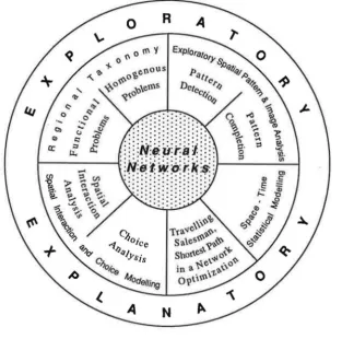
In principle, neural networks offer possibilities for addressing problems which require pattern recognition, pattern completion, pattern mapping, dealing with noisy data, systems which learn or adapt (adaptive control problems) and knowledge processing. The range of potential applications is impressive. Key candidate application areas in geographic information processing are summarized in Fig. 6. They are considered to include
• exploratory spatial data and image analysis (pattern detection and pattern completion via (un)supervised neural network architectures, especially in the field of environmental monitoring and management) in remote sensing and data rich GIS environments,
• homogeneous and functional regional taxonomic problems, especially in the case of very large data sets (see Openshaw et al. 1991 for evaluating different unsupervised neural network classifiers on census data for Britain),
• spatial Interaction and choice modelling (via supervised neural network architectures, see Fischer and Gopal 1992 for the application of multi-layered feedback forward networks with a back-propagation learning algorithm to model telephon traffic in Austria, or Openshaw 1992a to model journey to work flows),
• optimization problems such as the classical travelling salesman problem and shortest-path-problems in networks (via supervised neural network architectures, see Wilson and Pawley 1988 for a Hopfield network application to the travelling salesman problem), and
• space-time statistical modelling (via supervised or unsupervised neural networks, depending upon the problem under study) .
Fig. 6: Some Key Candidate Application Areas of Neural Networks In the Field of Geographic Information Processing
This list of problems addressable by the neural network approach is by no means exhaustive, but certainly reflects priorities for neural network applications in geographic information processing. In principle, neural networks may be developed to replicate the descriptive and predictive functions of current statistical and mathematical procedures of any complexity, often with an improved level of performance and accuracy (Openshaw 1992a).
[image:23.600.135.448.194.504.2]often quite large. The new methodology utilizes a neural network's ability to deal with large data sets, incomplete data and situations in which the diagnostic rules are not known a priori (see Dayhoff 1990).
6. Summary and Conclusions
Knowledge based geographic information systems will play an important role in decision and policy analysis (resource exploration, environmental monitoring and management, land use planning, motor vehicle navigation, distribution logistics, etc.). Geographic information systems without intelligence have only little chances to provide effective and efficient solutions to spatial decision making problems in the highly complex and imprecise decision making environment. The application of applied artificial intelligence techniques and principles to geographic information and analysis provides a great potential to meet the challenges encountered in developing the next generation of intelligent GIS. Spatial expert systems and artificial neural networks may be considered to be essential components of such systems. They fundamentally differ in their knowledge representation techniques from each other. Expert systems utilize the way of symbolic encoding of knowledge in form of production rules (forward/backward chaining systems), while artificial neural networks commited to the principle of interconnectivity represent knowledge implicitly rather than explicitly. Moreover, they have the ability to learn a desired mathematical or statistical function of any complexity from training samples and to generalise without imposing rigid assumptions as in the case of conventional spatial analysis procedures.
In the years to come, neural network architectures may be expected to complement rather than to replace rule-based knowledge processing and conventional data analysis tools, especially when geographical information systems are implemented on large, multi-processor systems. While developing rules and related heuristics to accomplish diagnostics may be extremely time consuming and only feasible in relatively simple and well-defined knowledge domains, neurocomputing shows greater flexibility to deal with situations typical for the GIS world, in which the data at hand are poor (incomplete, noisy, imprecise, etc.) from an analytical point of view, the detection of patterns and relationships in data-rich environments is important, but relevant theories and hypotheses for data analysis are missing.
References
Baldi, P. and Hornik, K. (1989): Neural networks and principal component analysis: Learning from examples without local minima, Neural Networks 2, pp. 53-58.
Burrough, P.A. (1990): Methods of spatial analysis in GIS, International Journal of Geographical Information Systems, vol. 4, pp. 221-223.
Clarke, M. (1990): Geographical information systems and model based analysis: Towards effective decision support systems, in Scholten, M.J. and Stillwell, J.C.M. (eds.): Geographical Information Systems for Urban and Reglonal Plannlng, pp. 165-175, Dordrecht et al.: Kluwer.
Dayhoff, J.E. (1990): Neural Network Architectures. An Introduction. New York: Van Nostrand Reinhold.
Fischer, M.M. and Gopal S. (1992): Neural Networks: General Principles with an Application to Modelling Telephon Communication, Paper prepared for the Symposium of the IGU-Commission on Mathematical Modelling, Princeton, August 1992.
Fischer, M.M. and Nijkamp, P. (1992): Geographic information systems and spatial analysis, The Annals of Regional Science, vol. 26(1) (in press).
Forsyth, R. (1989): The expert systems phenomena, in Forsyth, R. (ed.): Expert Systems, Principles and Case Studies, pp. 3-21. London et al: Chapman and Hall.
Goodchild, M.F. (1991): Progress on the GIS research agenda, in Harts, J., Ottens, H.F.L. and Scholten , M.J. (eds.): EGIS '91. Proceedings, Second European Conference on Geographical Information Systems, Volume 1, pp. 342-350. Utrecht: EGIS Foundation.
Graham, I. (1989): Inside the inference engine, in Forsyth, R. (ed.): Expert Systems, Principles and Case Studies, pp. 57-83. London et al: Chapman and Hall.
Grossberg, S. (1988): Nonlinear neural networks: Principles, mechanisms and architectures, Neural Networks 1, pp. 17-61.
Halmari, P.M. and Lundberg, C.G. (1991): Bridging inter- and intra-corporate information flows with neural networks, Paper presented at the Annual Meeting of the Association of American Geographers, Miami, April 13-17, 1991.
Han, S.-Y. and Kim, T.J. (1990): Intelligent urban information systems: Review and prospects, in Kim, T.J., Wiggins, LL. and Wright, J.R. (eds.): Expert Systems: Applications to Urban Planning, pp. 241-264. New York et al.: Springer.
Hopfield, J.J. and Tank, D.W. (1985): Neural computation of decisions in optimization problems, Biological Cybernetics 52, pp. 141-152.
Jacobs, A.A. (1988): Increased rates of convergence through learning rate adaptation, Neural Networks 1, pp. 295-307.
Kawaguchi, A., Motoda, H. and Mizoguchi, R. (1991): Interview-based knowledge acquisition using dynamic analysis, IEEE Expert (October), p. 47-60.
Kim, T.J., Wiggins, LL. and Wright, J.R. (eds.) (1990): Expert Systems: Appllcatlons to Urban and Reg Iona I Planning, pp. 191-201. Dordrecht et al.: Kluver.
Kobayashi, S. and Nakamura, K. (1991 ): Knowledge compilation and refinement for fault diagnosis, IEEE Expert (October), pp. 39-46.
Leung, Y. (1992) : Towards the development of an intelligent decision support system, in Fischer, M.M. and Nijkamp, P. (eds.): Geographical Information Systems, Spatial Modelling and Polley Evaluation , Berlin et al.: Springer (in press).
Masser, I. (1990): The Regional Research Laboratory Initiative: An overview, Regional Research Laboratory Initiative Discussion Paper No. 1.
Openshaw, S. (1990): A spatial analysis research strategy for the Regional Research Laboratory Initiative, Regional Research Laboratory Initiative Discussion Paper No. 3.
Openshaw, S. (1992a): Modelling spatial interaction using a neural net, in Fischer, M.M. and Nijkamp, P. (eds.): Geographical Information Systems, Spatial Modelling and Polley Evaluation, Berlin et al.: Springer (in press).
Openshaw, S. (1992b): Some suggestions concerning the development of artificial intelligence tools for spatial modelling and analysis in GIS, The Annals of Regional Science, vol. 26(1) (in press).
Openshaw, S., Cross, A. and Charlton, M. (1990): Building a prototype Geographical Correlates Exploration Machine, International Journal of Geographical Information Systems, vol. 4, pp. 297-311.
Openshaw, S., Wymer, C. and Charlton, M. (1991): An evaluation of three neural net classifiers on census data for Britain, Paper presented at the 7th European Colloquium on Quantitative and Theoretical Geography, Hasseludden (Sweden), September 5-8, 1991.
Ortolano, L. and Perman, C.D. (1990): Application to urban planning: An overview, in Kim, T.J., Wiggins, L.L. and Wright, J.R. (eds.): Expert Systems: Applications to Urban Planning, pp. 3-13. New York et al.: Springer.
Rosenblatt, F. (1958): The perceptron: A probabilistic model for information storage and organization in the brain, Psychoanalytic Review 65, pp. 386-408.
Rummelhart, D.E. and McClelland, J.L. (1986): Parallel Distributing Processing, Volume 1
and 2, Cambridge (Mass.): The MIT Press.
Rummelhart, D.E., Hinter, G.E. and Williams, R.J. (1986): Learning representations by back-propagating errors, Nature 323, pp. 533-536.
Shadbolt, N. (1989): Knowledge representation in man and machine, in Forsyth, R. (ed.): Expert Systems. Principles and Case Studies, pp. 142-170. London et al.: Chapman and Hall.
Smith, T.R., Penquet, D., Menon, S., and Agarwal, P. (1987): KBGIS-11. A knowledge-based geographical information system, International Journal of Geographic Information Systems, vol. 1, pp. 149-172.
Wang, F., Hall, G.B. and Subaryono (1990) Fuzzy information representation and processing in conventional GIS software: Database design and application, International Journal of Geographical Information Systems, vol. 4, pp.261-283.
Webster, C. (1990): Rule-based spatial search, International Journal of Geographical Information Systems, vol. 4, pp.241-259.
White, R.W. (1989): The artificial intelligence of urban dynamics: Neural net modelling of urban structure, Papers of the Regional Science Association 67, pp. 43-53.
Wilson, G.V. and Pawley, G.S. (1988): On the stability of the traveling salesman problem algorithm of Hopfield and Tank, Biological Cybernetics 58, pp. 63-70.