172
SHIV SHAKTI
International Journal in Multidisciplinary and
Academic Research (SSIJMAR)
Vol. 3, No. 3, May-June (ISSN 2278 – 5973)
Improvement in the GPSR Protocol to Increase Efficiency of
VANET
Preeti Yadav
11
Department of Computer Science, SITM, MDU Rohtak,
[email protected]
Puspender Sarao
22
Department of Computer Science, SITM, MDU Rohtak,
[email protected]
Impact Factor = 3.133 (Scientific Journal Impact Factor Value for 2012 by Inno Space
Scientific Journal Impact Factor)
Indexing:
173
Abstract
VANET is Vehicular Adhoc Network which is the application of MANET (Mobile Adhoc Network) envisioned for both safety and navigational purposes of vehicles on the road. Different routing protocols are used for communication in VANET. GPSR is one of the efficient protocols used for routing in VANET. But some problems exist with this protocol. GPSR is used to find the greedy path from one node to another node in a communication, but at some particular conditions (like when we choose a wrong node or any node is the last node of the network) it gets fails. So this research paper is basically giving solution to this problem by first determining the vehicles moving direction before forwarding any packet to the intermediate nodes. Second, important factor considered for GPSR is the speed of any vehicle.
Keywords: VANET, Routing Protocols, GPSR, Defense approach.
Introduction
Adhoc Network is the wireless network without any fixed routers and any node can dynamically connect to the network anywhere. Nodes of these networks function as routers to other nodes in the network. Like during emergency search and rescue operation or in any natural disaster all our infrastructure networks are destroyed. So here we use the Adhoc networks.
Figure1: Wireless Network Types
The static ad hoc network is then built through the inter-connection of antennas that are placed on top of the buildings. Static ad hoc networks are called static because here a node is free to enter the network elsewhere, but once he entered the network its geographic position is fixed.
MANET contains the nodes which are free to move around in MANETs. In consequence, the geographic region covered by a MANET may change frequently with the nodes‟ mobility, which makes it impossible to rely on any fixed infrastructure.
VANET is the enhanced application of MANET which is used to make our vehicles intelligent and thus helping us in Traffic Management, Accident avoidance, Event Coverage and Vehicle Discourse. VANET can make queries to other nodes and respond to other node queries.
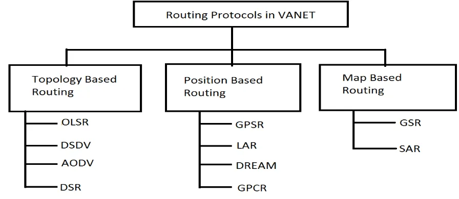
Routing Protocols in VANET
A routing protocol is the set of rules through which the routers communicate with each
174
used to make the routing decisions, these protocols can be classified into 3 categories
as:-Figure 2: Types of Routing Protocols
Topology Based Routing
The topology-based protocols use the information about the network topology and the state of communication links between nodes to perform the routing decisions.
OLSR (Optimized Link State Routing):-Optimized Link State Routing floods the network by the topology control messages in order to disseminate the link states information throughout the entire network showing which nodes are connected to which other nodes.
DSDV (Destination Sequenced Distance Vector):-DSDV computes and maintain routing info about all available paths in the networks even if no data traffic is exchanged.
DSR (Dynamic Source Routing):- Here whenever there is need of data transmission then only the route list are made and stored in route cache. Just before the data transmission we discover a new route dynamically.
AODV (Adhoc On-Demand Distance Vector):-AODV protocol is an on-demand protocol. It uses the table for storing the routes, one entry per destination.
Position Based Routing
Position-based protocols help in routing on the basis of geographic position of any node determined by GPS.
LAR(Location Based Routing):- LAR is a mechanism which attempts to reduce the control message overhead of Ad-hoc on-demand distance vector (AODV) routing protocol by flooding only the portion of the network that is likely to contain the route to destination.
DREAM (Distance Effect Algorithm for Mobility):-Here firstly we determine the direction in which the packet has to be routed. Then data packet is flooded in a restricted directional range without sending a routing packet.
GLS (Grid Location Services):- The GLS provides the location information for a node and other nodes location in the network topology. The routers are free to move anywhere in the network thus the network topology is changing rapidly and unpredictably.
GPSR (Greedy Perimeter Stateless Routing):- GPSR is the most popular protocol for dynamic network. GPSR requires that each node is able to obtain its current. Furthermore, it assumes that each node learns about the existence of its direct neighbors and their current positions.
Map Based Routing
175
GSR (Geographic Source Routing):-The first protocol to use the knowledge of the underlying map of the streets was Geographic Source Routing (GSR) which is mainly proposed for urban environments. (Lochert et al., 2007).
SAR (Spatially Aware Packet Routing):-The authors of (Tian et al., 2003) introduce the Spatially-Aware Packet Routing (SAR) protocol to improve the basic GSR with a recovery procedure to avoid a local maximum.
Existing Work
GPSR uses the “greedy algorithm” for forwarding the packets greedily to the neighbor with the nearest distance to the destination. For mobile and wireless networks GPSR is the efficient and responsive protocol. Vehicular networks and ad-hoc networks. Generally GPSR allows nodes to figure out who its closest neighbors are that are also close to the final destination the information is supposed to travel to. Assuming the wireless routers [nodes] know their own locations the Greedy forwarding algorithm will try to find the closest router which is also the closest to the final destination. When all neighbors are further away use the right hand rule and walk around the obstacle resume greedy forwarding as soon as possible to deliver message to destination
Problem with existing GPSR protocol
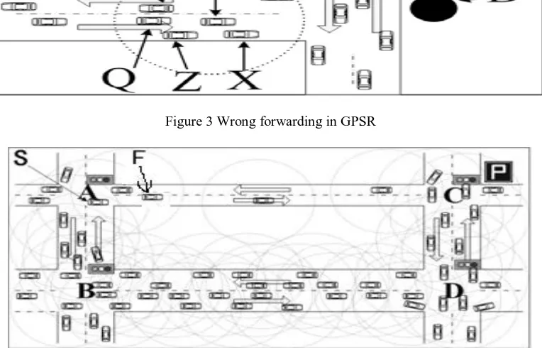
Drawback of the existing GPSR uses a longer path to the destination so the perimeter forwarding algorithm less efficient and cannot be used alone. In figure 3 we have 7 nodes P, S, Y, Q, Z, X and D. Suppose if node P wants to send a packet to node D, then by Greedy algorithm the closest node to D is Y. so the packet will be forwarded to Y. But Y is moving in the opposite direction i.e. away from D. So in a very short time node Y will become so far from D that the packet will be lost without sending it to node D. Thus wrong packet forwarding is done without considering the moving direction of node Y.
Figure 3 Wrong forwarding in GPSR
Figure 4 Wrong forwarding in GPSR
176
slot number. Using the GPSR we will choose F node as it is the closest node to S. But the due to sparse condition of road and heavy traffic the speed of will be slowed down. Therefore causing wrong packet forwarding and increase the packet loss rate and end-to-end delay. Although vehicle F is moving at high velocity, its speed is still much slower than the speed of wireless signal transmission and the packet will be discarded after a particular period of time.
Proposed Work
The Improved GPSR Algorithm focuses on the including of some new factors like vehicles moving direction, speed of any vehicle and the traffic density of the route. In this proposed work we used a concept of traffic light, traffic, congestion and an accident in a scenario where we are considering a city area. In this scenario, the vehicle will perform an automatic route finding by taking the observation of surrounding traffic, external interference and the traffic light. The vehicle will search their path by using effective shortest path routing. The connectivity problem too depends on these two factors. To resolve this problem there are some existing methods:-
Wait for the traffic signal to get green.
Whenever congestion found, find the appropriate shortest alternate path
The proposed algorithm we will use for finding the alternate shortest path is described below:
In this algorithm, the list of vehicles over a network is maintained. The basic idea is to find the shortest path whenever congestion is found or accident is detected or light goes red. First important factor here considered are any vehicles moving direction. If we want to send the packet from node A to P then we will look up all the nodes in between them and their directions. If any vehicle is moving towards the node P the node will be considered a part of the communication for sending the data. Secondly the speed of all the vehicles between A to P going towards P is considered. The node with highest speed is given priority. And if any node is moving away from node P then node with minimum speed is given priority.
Conclusion
VANET is an emerging and attractive technology dedicated to safety and comfort services to the vehicle users. It supports highly dynamic topology and unpredictable channel distribution; it forms a basis to generate endless network connectivity among the vehicular nodes by providing a suitable routing protocol algorithm. In the proposed work we represent an algorithm to solve the wrong node choosing and congestion problem in all path networks and to get such a path that will provide efficient data transmission over the network. In the network we divide the whole network into sub-networks and we perform the transmission over the sub goal and to achieve the efficient and reliable data transmission.
Future Enhancements
In the proposed work we prefer the changes in terms of algorithmic work. We can extend it as the protocol based change. It means as the protocol will be applied all the changes will be applied implicitly. Collision warning, traffic congestion alarm, lane-change warning, road blockade alarm (due to construction works etc.) are among the major safety related services addressed by VANET. The major challenges in the research work for VANET is data sharing, privacy, designing routing protocols and network formation.
References
[1] Ch.Vijaya Durga et al,” An efficient protocol for intelligent transportation in
vehicular Adhoc networks”,(IJAEST) international journal of advanced engineering sciences and technologies vol no. 5, issue no. 2,2011, pp. 301 – 309,
[2] Gabriel Agamemnon at el,” Robust inference of principal road paths for intelligent
177
[3] Ahmad et.al. ,”A routing strategy for vehicular ad hoc networks in city”, supported
from EUIST Project Car Talk , 2006
[4] Rajesh Rajamani et al,” On spacing policies for highway vehicle automation”,
American control conference Chicago, Illinois June 2000
[5] Mohammad Nekoui et al,” The effect of intellidrive on the efficiency of highway
transportation systems”, Hindawi publishing corporation international journal of vehicular technology volume 2011, 11 pages,2011
[6] Graham parker et al,”the security of vehicular ad hoc networks”, ACM, 2005 [Sept
2006] Vladimir Bychkovsky, Bret Hull, Allen K. Miu, Hari Balakrishnan, and Samuel Madden. A Measurement Study of Vehicular Internet Access Using In Situ Wi-Fi Networks. In 12th ACM MOBICOM Conf., Los Angeles, CA, September 2006.
[7] June 2003 Lockhart, C., Hartenstein, H., Tian, J., Fusser, H., Hermann, D., Mauve, M. (2003), “A routing strategy for vehicular ad hoc networks in city environments,” Intelligent Vehicles Symposium, 2003. Proceedings. IEEE, vol., no., pp. 156-161, 9-11 June 2003.
[8] Maxim et al, ”the security of vehicular ad hoc networks”,ACM,2005
[9] Gang Liu and Han Guo,” some aspects of road sweeping vehicle automation”, IEEE