ISSN : 2581-7175 ©IJSRED: All Rights are Reserved Page 691
Design and Construction of Earthquake Detection and Location
Reporting System on Google Map
Zin Mar Cho, Win Zaw Hein
Department of Electronic Engineering, Mandalay Technological University Mandalay, Myanmar
Abstract
A large number of people died in every year caused by earthquake around the world. As a result of insufficient information, emergency service such as safely cannot be provided in time to the occurrence of earthquake places. Therefore, many lives have been lost for earthquake victims. The goal of this proposed system is to know the magnitude of earthquake in time and show the details of earthquake in google, mobile etc. This proposed system aims to design by using sensors and controller and empowering them to communicate with each other through wireless technologies. This system has two devices: the detector and reporter. The detecting device was devised using simulated sensor program. MPU 6050 sensor detects the occurrence of the earthquake. GPS is used to support identification of the location such as latitude and longitude of the earthquake and sent it to the Arduino uno. Wi-Fi module is used to connect the controller and sent to the server. Further reporting device could be done to send data on the website for user interface. Finally, the location, origin time and magnitude of the earthquake are shown on the Global Map (Google Map) by Wi-Fi module.
Keywords- IMU Sensor,GPS, Wi-Fi module (ESP8266), Google Map,Internet of Things (IOT)
I. INTRODUCTION
An earthquake is the shaking of the earth, causing by the breaking and shifting of underground rock. Therefore they can cause tsunamis, landslides and avalanches. Today every country is facing with serious problems of earthquakes. Further many machines for earthquake have been developed with newest technologies to support better life. Convenient living is an important part for people lives to save the hazards places. Most of the people are died from earthquake because the actual location and origin time of earthquake cannot be provided not only in time and information but also emergency facilities. By this proposed system, when sensor is shaked, sensor immediately detect it and sends the data to the controller and reports information to the website. Then the public can easily know the
occurrence place of earthquake and check the location of earthquake by using Google Map. This proposed system was constructed with sensor and server.
II. LITERATURE REVIEW
Some of the previous important literatures that have been studied are discussed below. Hima MS, August 2016[1] presented Earthquake Indicator Using Arduino. This system consisted of two parts, earthquake indicator and a highly sensitive accelerometer. The hardware includedaccelerometer, Arduino, earthquake, vibration. This paper was capable of providing immediate alert enabling us to foresee the disaster and to take preventive measures accordingly. This product was affordable for common people in terms of product cost and installation cost. This
ISSN : 2581-7175 ©IJSRED: All Rights are Reserved Page 692 product can be modified and used as a knock and
shake detector for ATMs, vehicles or door-break alarms.
Dr. Deepankar Choudhury, 2013 [2] presented Size of Earthquakes. This paper was indicated that seismogram was visual record of arrival time and magnitude of shaking associated with seismic wave. Analysis of seismogram allowed measurement of size of earthquake. The purpose of this system wasthe difference of Intensity scale and Richter scale. Intensity scale measured by the amount of damage caused in human terms. Richter scale was based on amplitude of the waves and related to earthquake total energy.
Peter Bormann, Joachim Saul [3] did the research: “Size of Earthquakes”. This paper was written that the magnitude was the most frequently determined and commonly used parameter to characterize an earthquake. The author was divided the kinds of earthquake which were Common Magnitude Estimatesfor the Sumatra 2004 Mw 9.3, Earthquake Magnitude Saturation and Biases Due to Earthquake Complexity and Proposals for Faster Magnitude Estimatesof Strong Earthquakes. The main reason of the author was the lack of manpower to make competent measurements of these parameters interactively for the large amount of data recorded nowadays.
III. BLOCK DIAGRAM OF OVERALL SYSTEM
Block diagram of overall system is shown in Fig (1). This system incorporates ESP-8266, GPS, IMU Sensor and Web server.
IMU Sensor Monitoring Unit User application (Map) GPS Arduino Uno Power Supply Wi-Fi Module Web Server
Figure1. Block diagram of overall system
An ArduinoUnowas used for automation and controlling of the other supporting devices: those are IMU sensor and GPS module. This paper was concerned with a practical model of an earthquake and information system. Basically, this system consisted of three sections: The first onewas the about of the helical spring,the second was shaking or vibrating through IMU sensor. This sensor continuously sensed for any large scale of acceleration and tilt angle. The third section was the location of the measurement device that was done by GPS module. GPS supported the location of earthquake in terms of two coordinates that are latitude and longitude to web server via Node MCU (IoTs). Monitoring units might be laptop PC or any smart phone which support Google map application.
IV. BACKGROUND THEORY
A. Node MCU
NodeMCU is an open source IoT platform and the name of a micro controller designed by Espressif Systems. It is based on the ESP-12 module and it contains memory to be installed control-program and simply connects it to a computer with a USB cable or power it with an AC- to –DC adapter or battery to get started. It can be powered via either the USB connection or with an external power supply.
B. GPS Based System
ISSN : 2581-7175 ©IJSRED: All Rights are Reserved Page 693
C. Arduino Uno
The Arduino Uno is a microcontroller board based on the ATmega328 (datasheet). It has 14 digital input/output pins (of which 6 can be used as PWM outputs), 6 analog inputs, a 16 MHz ceramic resonator, a USB connection, a power jack, an ICSP header, and a reset button. It contains everything needed to support the microcontroller; simply connect it to a computer with a USB cable or power it with an AC-to-DC adapter or battery to get started.
The Uno differs from all preceding boards in that it does not use the FTDI USB-to-serial driver chip. Instead, it features the ATmega16U2 (ATmega8U2 up to version R2) programmed as a USB-to-serial converter.
D. MPU-6050
The MPU 6050 is the world’s first integrated 6-axis motion tracking device. It contains 3-axis accelerometer and 3-axis gyroscope in one chip. It can captures x, y and z with 16-bits analogue to digital conversion hardware for each channel. MPU-6050 uses I2C for communication which is a multi-master, multi-slave, single-ended, serial computer bus with low speed using only two wires: SCL (clock) and SDA (data) lines. An accelerometer is an electromechanical device used to measure acceleration forces. It also has sensitivity, usually expressed in mV/g. If no additional forces act on the accelerometer, the magnitude of the accelerometer is 1g, and the sensor’s rotation can be computed from the position of the acceleration vector.A gyroscope measures angular velocity (the rate of change in orientation angle), not angular orientation itself. Each gyroscope measures the rotation around one axis. Averaging the data that comes from accelerometers and gyroscopes can produce a better estimate of orientation than obtained using accelerometer data alone.
Calculating formula for tilt angle by using atan2 function is following,
= ( ) ×
= ×
= ( ) × (1)
where,x - direction goes from side to side.
Y-direction goes forward and backward. Z-direction goes up and down
-angle of x. (degree) - angle of y. (degree) - the angle of z. (degree)
E. Appliance of Web Technology
Web technologies that used to develop the system server side are listed as follows:
1). Apache was used as a web server.
2). MYSQL was chosen to be the main database. 3). HTML, PHP, JavaScript and CSS was to develop the Web pages.
4). Google Map JavaScript API was used to convenience of Google Map to the Web pages.
Now a day web is the most critical technology to carry data via internet. There are four main parts in the web technology. They are (i) Hypertext Document (ii) Web Server (iii) Web Browser and (iv) Database.
1) Hypertext Document
Hypertext document is a text document including HTML element. HTML was used for developing of web pages.
2) Web Server
ISSN : 2581-7175 ©IJSRED: All Rights are Reserved Page 694
3) Web Browser
The basic function of web browser is to carry the data from user to web server and vice versa. The most popular web browsers are Google Chrome, Mozilla Firefox, Microsoft Internet Explorer, Apple Safari and Opera.
4) Database
Database is a collection of information that is organized in systematic way. The data can be stored in the server in the form of table, text, scripts, reports, graphics and etc. The database is developed using PHP languages.
V. SYSTEM FLOW CHART AND
METHODOLOGY
There are three main parts in this system; calculation spring constant, shaking sensor and location reporting. Helical spring was used to store energy and maintain a force between contacting surfaces. Shaking or vibrating process was done by IMU sensor and this sensor provided tilt angles of the movement. This can be change to magnitude of the earthquake and the data was sent to the web server via IoTs (Node MCU). MySQL database was used for data storage to monitor the information of the earthquake and the location of the sensor device was shown by using a Google Map application.
Figure 2.Example of a Seismogram [4].
Figure 2 shows the example recorded signal of the earthquake. It was a Record of a short-period Wood–Anderson seismograph
(frequency-magnification curve) of a local earthquake. In the figure, vertical axis is amplitude of earthquake and horizontal axis is time.P marks the onset of the first arriving longitudinal P wave, and S the onset of the much stronger secondary, transverse polarized shear wave. Note the long tail of coda-waves following S.
ISSN : 2581-7175 ©IJSRED: All Rights are Reserved Page 695 Figure3.Flow Chart of the System
From figure 2 the magnitude of the earthquake can be measured by -
= log( ) + 3log(8 × ) − 2.93 (2)
where is the magnitude of earthquake, is Maximum amplitude of the earthquake, t is the time difference between P and S.
When the sensor was occurred getting vibrate, it was needed to know the latitude and longitude of the sensor from GPS module. The received data was sent to store in the databased. The stored data was applied on google map to monitor the location and magnitude of the earthquake.
VI. TEST AND RESULT OF SYSTEM
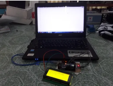
In this system, Arduino Uno was used as a controller to all modules. Arduino Uno has 16 I/O pins. A4 pin of ArduinoUnowas connected to SCL (Serial Cluck) pin of IMU and A5 pin of Arduino
Unowas connected to SDA (Serial Data) pin of IMU sensor. D3 pin of Arduino Uno was connected to RX(receive) pin of GPS and D4 pin of Arduino Uno was connected to TX(Transmit) pin of GPS as shown in Figure(4).
Figure 4. Hardware Components Setup of the System
Figure 5 shows the testing of MPU sensor with Arduino UNO on the circuit board and when it was successfully worked, the monitor was displayed the amplitude and magnitude in millimeters. Arduino IDE software and C++ language were used for Wi-Fi module.
Figure 5. GPS Sensor Testing.
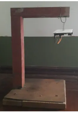
ISSN : 2581-7175 ©IJSRED: All Rights are Reserved Page 696 Figure 6. IMU Testing with Frame
Figure 7 shows the lists of results from IMU sensor. In the upper part of the figure, left side of data were raw data of the sensor and right side are tilt angles (in degree) of the sensor that converted from the left. When parameters; Time difference between first wave and peak time (t), Amplitude Max (A) form the middle part of the figure were inserted to the equation (2), the magnitude of the earthquake could be calculated as a result. The result waveform was shown in figure (8).
Figure 6.The Amplitude and Magnitude of Earthquake.
Figure 8.The Magnitude of Earthquake with Time.
Figure 9.The Capture Photo of Earthquake Message in Serial Monitor. -20
0 20 40
0 20 40 60
ISSN : 2581-7175 ©IJSRED: All Rights are Reserved Page 697 Figure (9) shows the example capture photo of
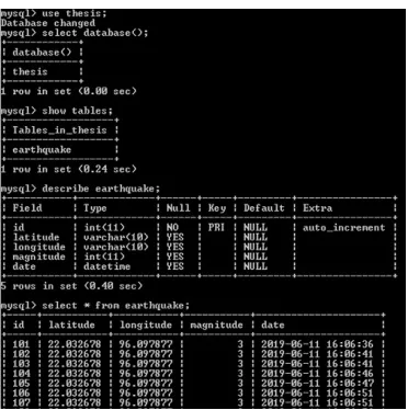
the information of earthquake in serial monitor. After receiving the information, those data were directly sent to the MySQL Database shown in figure (10).
Figure 10.Screenshot of Results Data Stored in Database
In figure (10), the data was inserted into the database via Node MCU. The table was needed to be prepared to accept the values from the controller. This problem was solved by using GET method and it was used to get the data from the controller. Figure (10)shows the data of Latitude and Longitude respectively in the database. All data were stored in the database of MySQL server. The stored data was for locational information that can be checked easily by any map application through internet.
Figure 11. Table of earthquake message
Figure (11) shows the table of earthquake message. After receiving this earthquake message in the station, public know that the earthquake occurred and also know magnitude, Latitude and Longitude coordinate of the earthquake.
VII. CONCLUSION
This system consisted of earthquake detection and location reporting using web server to the control center. The platform of the system was used MPU-6050 sensor, Arduino Uno, GPS, ESP-8266 and web application. The occurrence of earthquakewas detected by MPU-6050 sensor which gave the accurate information and GPS was measured the exact location of vehicle in terms of latitude and longitude. Therefore, the location of occurrence of earthquakecan be checked easily by web browser using map application.
ACKNOWLEDGMENT
Author thanks to U Win Zaw Hein, Associate Professor, Department of Electronic Engineering for kind permission to prepare for this paper, for he valuable suggestion, supervision, encouragement and sharing he experience to write this research. And also, the author is also thankful to all of her teachers from Department of Electronic Engineering Mandalay Technological University.
REFERENCES
[1] Hima MS, JosphinSubha, Kalyani Devi G, KarthikaSankaran, Naveen S, “Earthquake Indicator Using Arduino”, Department
of Electronics and Communication Engineering, LBSITW, Trivandrum, Kerala, India, August 2016.
[2] Dr. Deepankar Choudhury, ‘Size of Earthquakes”,
Department of Civil Engineering, IIT Bombay, Powai, Mumbai 400 076, India, 2013.
[3] PETER BORMANN, JOACHIM SAUL, “Size of Earthquakes”, Geo ForschungsZentrum Potsdam, Potsdam, Germany.
[4] PETER BORMANN, JOACHIM SAUL, “Earthquake
![Figure 2.Example of a Seismogram [4].](https://thumb-us.123doks.com/thumbv2/123dok_us/9848443.1971528/4.612.75.289.520.605/figure-example-of-a-seismogram.webp)