Forestry & Natural-Resource Sciences Last Correction: Mar. 28, 2017
EFFECTS OF FOREST THINNING ON STATIC HORIZONTAL
POSITION ACCURACY COLLECTED WITH A
MAPPING-GRADE GNSS RECEIVER
Ramazan Akbulut, Zennure Ucar, Pete Bettinger, Krista Merry, Shingo Obata
Warnell School of Forestry and Natural Resources, University of Georgia, Athens, GA 30602 USA
Abstract.The static horizontal position accuracy of a mapping-grade GPS receiver was tested in two
different pine forest conditions (pre-thinning and post-thinning of a 20-year old loblolly pine (Pinus taeda) stand). The main objective of this study was to describe the horizontal position error that might be observed shortly before and shortly after a thinning operation. In general, by using the Trimble Juno T41 series receiver, we found the static horizontal position error prior to thinning averaged 4.14 m when each individual point was assumed to be as a sample. When the northing and easting values of each epoch were averaged, the error was 1.57 m. A few days after thinning, the horizontal position error averaged 2.32 m for individual samples, and 1.02 m when the northing and easting values were averaged. Subsequent post-thinning measurements showed further improvements in static horizontal position accuracy. The static horizontal position error was 1.33 m 9 days later (0.52 m if northing and easting values are averaged) and 2.29 m 14 days later (0.58 m if northing and easting values are averaged). Therefore, findings suggested that the magnitude of horizontal position error decreased after the thinning operation. Further, according to rose diagrams representing the direction of error, the general direction of pre-thinning error seems different than the direction of post-thinning error, and there is some agreement that the post-thinning positions captured have the same general direction of error.
Therefore, the quality of the data and the density of the trees around the data collection area are dependent.
Keywords: Global navigation satellite systems, global positioning systems, static horizontal accuracy.
1
Introduction
In practice, foresters and land managers frequently navigate and record positions of landscape features us-ing global positionus-ing systems (GPS). Internationally, the technology is more commonly known as global navi-gational satellite systems (GNSS). The accuracy of po-sitional data collected with this technology has been of great interest to forest managers, particularly since 2000, when the United States NAVSTAR system ceased to incorporate selective availability into emitted signals. Navigational accuracy is important for forest sampling and forest operation design. Mapping accuracy is im-portant in representing landscape features appropriately, and in the multitude of subsequent spatial analyses that can be facilitated through the use of a geographic
in-formation system (GIS). Therefore, in the last 10 years, assessments of GPS accuracy in forested environments have steadily been provided by researchers throughout the world in an effort to better understand the role of GPS to support the management and research of forests (e.g., Ransom et al. 2010, Simwanda et al. 2011, Wing and Frank 2011, Edson and Wing 2012, Unger et al. 2013, Frank and Wing 2014, Brach and Zasada 2014, Ucar et al. 2014, Kaartinen et al. 2015, Weaver et al. 2015, Pirti 2016). These studies have investigated a variety of grades of equipment, the ability for real-time space-based or otherwise augmented data to improve accuracy, the effects of weather and forest condition on accuracy, and the general ability of GPS (given these and other variables) to precisely determine where one stands on the Earth.
Copyright©2017 Publisher of theMathematical and Computational Forestry & Natural-Resource Sciences
Multipath error is one of the most significant sources of error in positions determined using GPS technology (Ragheb et al. 2007). Previously conducted research re-garding mapping-grade GPS receivers has suggested that multipath effects can account for about 50 percent of the horizontal position error observed (Danskin et al. 2009a). Based on common sense and intuition, the density of the forest would seem to contribute to greater positional error, and this has also been illustrated through recent research conducted in forested environments (Ordo˜nez et al. 2012, Bettinger and Fei 2010). Further, recent research within forested conditions has also suggested that the spatial arrangement of trees near a GPS data collection point can affect the general direction of the er-rors observed (Bettinger and Merry 2012). The objective of this study was to capitalize on the timing of a for-est thinning operation within the Whitehall Forfor-est GPS Test Site area, and to describe the differences in static horizontal position error that might be observed prior to, and shortly after the removal of trees. Our hypoth-esis was that there would be no observable differences in the magnitude and direction of horizontal position er-ror when comparing the pre-thinning and post-thinning static positions on the same sidereal time. We therefore expected to observe differences in these regards between the pre-thinning and the post-thinning error. However, factors in addition to the thinning operation could create observable differences in the magnitude and direction of horizontal position error, making the observable differ-ences attributable to the thinning operation moot.
2
Methods
2.1 Study site This study was conducted on the White-hall Forest GPS Test Site1near Athens, Georgia (USA). The test site was established in 2004, and consists of 40 control points, each represented by a brass survey cap encased in cement. The position of three control points was established using an Ashtech Locus survey-grade GNSS receiver that collected static horizontal positional data for 4 hours. These positions were subsequently accepted as National Spatial Reference System (NSRS) positions, and were processed using the United States (US) Department of Commerce, National Oceanic and Atmospheric Administration’s Online Positioning User Service2. Through this process, the positional precision of these three control points (monuments) was noted to be less than 2 cm. Using these three monuments as a base, registered surveyors measured a closed traverse net-work that connected the other 37 control points within the Whitehall Forest GPS Test Site using a Topcon GTS-211D instrument. The surveyors reported the precision of
1http://warnell.forestry.uga.edu/Warnell/Bettinger/GPS/
2www.ngs.noaa.gov/OPUS
the closed traverse network to be 1/92,137. We therefore assume that the complete set of control points within the Test Site are represented with horizontal positions that are known to within about 2 cm, and thus the control points within the Whitehall Forest GPS Test Site can be considered a highly accurate model around which GNSS equipment could be tested.
In 2016, a forest thinning operation was implemented on Whitehall Forest; the operational area covered only one (number 37, Figure 1) of the 40 test points on the Whitehall Forest GPS Test Site. The UTM location of the test point, using North American Datum 1983, UTM Zone 17, is 3751916.9283 (northing), 282085.8958 (easting). The stand surrounding the control point prior to thinning contained 1,214 trees per hectare of 20-year old loblolly pine trees (Pinus taeda) which amounted to 42.5 m2 per hectare basal area. The average diameter at breast height (DBH) was 20.0 cm, and the average total height of dominant trees was approximately 20 m. After thinning, the stand surrounding the control point contained 489 trees per hectare and 16.1 m2per hectare basal area of loblolly pine trees. The average DBH of trees after the thinning was 19.5 cm.
Figure 1: An overhead view of the study area prior to the thinning operation using the 2015 USDA National Agriculture Aerial Imagery Program (NAIP) moasic for Clarke County, Georgia.
real-time position augmentation system. GPS receivers that can access and use the WAAS signal are potentially able to improve the determination of static horizontal positions in forested areas (Danskin et al. 2009b). We enabled the WAAS feature when collecting data during this study, however a signal lock to the WAAS system was not guaranteed.
Visits to the study area were timed in such a way as to collect data at the same time on different days given that the orbit of a United States NAVSTAR satellite is one-half of a sidereal day. Slightly shorter than a proper terrestrial day, a sidereal day (23 hours, 56 minutes, 4 seconds) is a function of the radius of Earth’s orbit and the gravitation parameter of the Sun (Fokker 1957). A sidereal day is a time scale that is based on the rate of the Earth’s rotation; it is approximately 239.5 seconds less than one solar day (Agnew and Larson 2007). The length of a sidereal day is not exact, and may vary periodically (on the order of fractions of milliseconds) due to variations in atmospheric angular momentum and other geophysical effects (Frostman et al. 1967). Yet from any given point on Earth, an object in the sky (a GPS satellite, in this case) should be found at the same location on different dates using this time-keeping system. Although US NAVSTAR satellites complete two orbits of Earth each day, with each subsequent day a satellite should be over the same position on Earth 4 minutes earlier than the previous day (Leick et al. 2015). Given this, the orbital ground track of the satellites should be approximately the same each day after taking into account the sidereal day orbital period.
An assumption concerning potential multipath effects (one the main sources of error in the use of GPS in a forested environment) is that these would also repeat if the reflective environment (trees, in our case) remained the same when using the same GPS equipment (Dong et al. 2016). In our study, the approach we used required an assessment of horizontal positions determined at the same sidereal lag (roughly 4 minutes earlier with each passing day), yet given the practicalities of the data collection effort the data are not perfectly matched down to the second, and thus data are not exactly collected during the sidereal lag in the post-thinning data collection period (a similar problem noted in Dong et al. 2016). Further, the ability to re-gain the satellite constellation each day can be damaged by the fact that when other systems are used, the sidereal days cannot be simultaneously replicated. For example, GLONASS satellites have an orbital period of 11 hours and 15 minutes (Leick et al. 2015); therefore, a GLONASS satellite should be over the same position on Earth 90 minutes earlier than the previous day. Since the GPS equipment we tested was not GLONASS-enabled, we were able to collect data theoretically at the same
time on subsequent days corresponding to the sidereal day of the US NAVSTAR system.
Our intent was to sample pre-harvest and post-harvest static horizontal positions on test point 37, within days of the operation (which itself required less than one week to complete). Scheduling the pre-harvest sampling effort was difficult due to uncontrollable factors. By contract, the logging contractor had over a year to complete the thinning treatment, yet the actual date of treatment changed several times throughout the year due to market conditions and due to the work schedule of the contrac-tor. Three or four instances over this period of time we were cautioned that the logger may enter the site, only to find that the thinning operation was to be delayed. Finally, with three days’ notice, we learned when the thinning treatment would actually occur. Given our work schedules, we were only able to collect data once prior to the thinning operation. We visited the GPS Test Site three times after the thinning operation. Each epoch, or moment of specific time of a captured position, was considered a sample. During the data collection process, we recorded position fixes at 2-second time intervals. An automatic function within the Trimble receiver was used to complete this process. During the data collection process, the receiver was also set to automatically utilize the WAAS signal if it was available. When the WAAS signal was used, the receiver notified the user audibly with the phrase ”corrected GPS” and if WAAS was not used, it notified the user with the phrase ”uncorrected GPS.” Due to the speed at which the status changed, we concluded that about one-half of the recorded posi-tions were enhanced using the WAAS signal. Since the amount of continuously received, corrected epochs was not recorded by the device, we were unable to develop a measure such as the signal interruption probability proposed by Bastos and Hasegawa (2013), which would have, in our case, been considered a signal correction interruption probability. Positional dilution of precision (PDOP) values ranged from about 2 to 5 throughout the data collection process, and signal to noise ratio (C/No) was generally above 25. In these ranges, they have lit-tle impact on static horizontal position accuracy within forests (Weaver et al. 2015).
and seventeen days after the conclusion of the thinning operation.
3
Results
3.1 General Results The static horizontal position error prior to the thinning operation averaged 4.14 m when each individual determined position was assumed to be a sample (Table 1). If one were to have averaged the northing and easting values of these positions, then compared this to the true position, the error would have been 1.57 m. The horizontal position error 14 days after the pre-thinning measurements, and a few days after the conclusion of the thinning operation, averaged 2.32 m when each individual determined position was assumed to be a sample. If one were to have averaged the northing and easting values of these positions, then compared this to the true position, the error would have been 1.02 m. From a straight comparison of the individual sidereal epochs, the improvement was 1.81 m; a comparison of the average position of the 49 sample epochs to the true positions suggests a 0.55 m improvement in static horizontal accuracy.
Twenty-three days after the pre-thinning measure-ments, the static horizontal position error averaged 1.33 m when each individual determined position was assumed to be a sample; the error was 0.52 m if one were to have averaged the northing and easting values of these posi-tions. In comparing the individual sidereal epochs, the improvement was 2.81 m; a comparison of the average position of the 49 sample epochs to the true positions sug-gested a 1.05 m improvement in static horizontal accuracy. Twenty-eight days after the pre-thinning measurements, the horizontal position error averaged 2.29 m when each individual determined position was assumed to be a sam-ple; the error was 0.58 m if one were to have averaged the northing and easting values of these positions. Here, in comparing the individual sidereal epochs, the improve-ment was 1.85 m (as in the immediate post-thinning situation); yet a comparison of the average position of the 49 sample epochs to the true positions suggested a 0.99 m improvement in static horizontal accuracy.
3.2 Sidereal Epoch Results Here, we compare the pre-thinning positions determined to the post-thinning positions determined, on the associated sidereal epoch (the specific moment in time on the same sidereal day). As suggested, of the 49 pre-thinning samples, we col-lected three associated post-thinning measurements at the time of the sidereal epoch. This required collecting samples 56 minutes earlier in the day on October 12, 92 minutes earlier on October 21, and 112 minutes ear-lier on October 26. Comparing the pre-thinning data to the October 12 data, we found an average
improve-ment in static horizontal position accuracy of 1.81 m (95% confidence interval: 1.03-2.60 m). Comparing the pre-thinning data to the October 21 data, we found an average improvement in static horizontal position accu-racy of 2.81 m (95% confidence interval: 2.05-3.07 m). Comparing the pre-thinning data to the October 26 data, we found an improvement in static horizontal position accuracy of 1.85 m (95% confidence interval: 1.04-2.66 m). Of the 49 post-thinning positions, 90% from Octo-ber 21 represented improvements over the pre-thinning positions, while only 77% from both October 12 and October 26 represented improvements in this regard over the pre-thinning static horizontal positions.
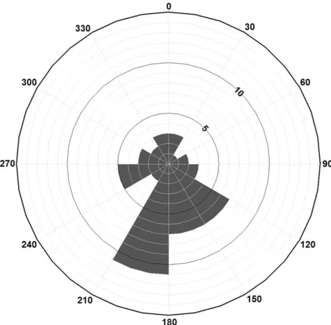
Figure 2: Rose diagram of the direction of error (number of samples per azimuth class) three days prior to the implementation of the thinning operation.
Table 1: Static horizontal position accuracy results from pre- and post-thinning.
Northing (m) Easting (m) Difference (m)
True position a 3,751,916.93 282,085.90
Average difference of samples b
Pre-thinning (9/28/2016) — — 4.14
Post-thinning (10/12/2016) — — 2.32
Post-thinning (10/21/2016) — — 1.33
Post-thinning (10/26/2016) — — 2.29
Average determined positionc
Pre-thinning (9/28/2016) 3,751,915.37 282,085.74 1.57 Post-thinning (10/12/2016) 3,751,916.29 282,085.10 1.02 Post-thinning (10/21/2016) 3,751,916.71 282,085.42 0.52 Post-thinning (10/26/2016) 3,751,916.36 282,085.79 0.58
aUTM zone 17, North American Datum 1983
bComparing each sample epoch to the true position
cAverage horizontal position of the 49 sample epochs
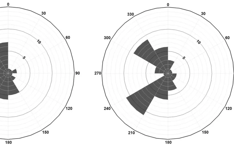
Figure 3: Rose diagram of the direction of error (num-ber of samples per azimuth class) three days after the conclusion of the thinning operation.
0
270 .90
180
Figure 5: Rose diagram of the direction of error (number of samples per azimuth class) seventeen days after the conclusion of the thinning operation.
from the immediate area around the GPS Test Point. Further, there is some agreement that the post-thinning measurements have the same general direction of error. However, upon closer inspection of the direction of error observed at the exact sidereal epoch amongst the four visits to the GPS Test Site, only 10 of the 49 samples had the same direction of error.
4
Discussion
We considered this study to have two novel aspects. First, it appears to be the first of its kind to measure, albeit on a limited time scale, the static horizontal posi-tion accuracy just prior to, and shortly after a thinning operation. The results we obtained are consistent with many other research studies in that they indicate that the density of the forest seems to affect positional quality. Therefore, a large portion of the error can be attributed to the last 20 m or so that a GPS signal travels prior to entering the receiver. This rather insignificantly narrow layer of the troposphere can contains enough vegetative material to create a multipath environment that nearly doubles the error observed between a southern pine stand that has been thinned to a reasonable residual basal area level (16.1 m2 per hectare, or 70 ft2 per acre) and the same pine stand that in its pre-thinned state was heavily stocked (42.5 m2per hectare, or 185 ft2 per acre) for its age (20 years).
Second, this study attempted to collect data from the US NAVSTAR constellation at the same time with each visit to the study site, based on the sidereal day. Theoretically, during data collection, each of the satellites viewable in the sky above would have been at the same place (inclination above the horizon, azimuth). What this suggests is that under the best of circumstances, the satellite constellation should have been nearly the same at the exact point of data collection for each of the 49 samples. And ideally, the GPS receiver would have then used the same satellites to determine the static horizontal position of the GPS test point. Unfortunately, we had no control over the use of satellite signals by the GPS receiver. And it is obvious that the static horizontal position error and direction were different for each of the 49 samples. Since the post-thinning collection of trees around the GPS test point did not change during the post-thinning data collection period, one cause of these differences might be the movement of the tree crowns through wind action. Another might be attributable to minor variations in the satellite constellation as a result of imperfect matching of the sidereal lag (Dong et al. 2016).
It has been suggested that multipathed signals should repeat when the arrangement of the GPS constellation re-peats, assuming landscape features remain fixed (Agnew and Larson 2007). Within serious multipath environ-ments, models have been developed to reduce multipath effects, even with satellite orbit repeat lags using sidereal days or other measures of orbital repeat time (Dong et al. 2016). Others (e.g., Zheng et al. 2005, Ragheb et al. 2007) have also proposed methods for utilizing data collected at times consistent with the sidereal epoch to separate good signals from noisy signals, then to derive a multipath model and effectively remove multipath from GPS observations. This approach would be of value if the goal were to actively collect data at one place for long periods of time. Given the nuances of our study, it is unfortunate that we are unable to carry out or apply the work of others in these regards.
appropriately for a study such as this. In any event, we felt that our data collection protocols were rigorously defined. Among other facets, we used the same GPS receiver at the same sidereal time on different occasions (visits to the study site), we held the GPS receiver in the same manner (Weaver et al. 2015), and we held the GPS receiver at the same height above the ground (plumbed over the test point). The study environment also seemed fairly fixed; the same number of trees were present during the post-thinning data collection period. However, one thing we could not control was the action of the tree canopy with respect to minor wind events. This potential factor was not measured, and thus we can only suggest that it might have influenced our findings.
5
Conclusions
From this research study we concluded, as expected, that the magnitude of error and the direction of error did in fact change shortly prior to, and shortly after a forest thinning operation. The results confirm previously suggested findings that the density of trees near a GPS data collection area does affect the quality of the static horizontal positions determined. Further, the results also support the previously suggested idea that the spatial arrangement of trees nearby a data collection area can affect the general direction of the horizontal position error. However, attempts to replicate the satellite constellation by assuming satellites would be positioned similarly in the sky above during each sidereal epoch seems to be an elusive endeavor when assessing static horizontal accuracy in a forested environment. If one cannot control the movement of objects (tops of trees), exact differences in static horizontal position accuracy between pre- and post-treatment states of forests are impossible to determine, and only relative differences in static horizontal position accuracy are possible to understand.
Acknowledgements
We appreciate the thoughtful and insightful peer re-views of this research.
References
Agnew, D.C., and K.M. Larson. 2007. Finding the repeat times of the GPS constellation. GPS Solutions. 11(1): 71–76.
Bastos, A.A., and H. Hasegawa. 2013. Behavior of GPS signal interruption probability under tree canopies in different forest conditions. European Journal of Remote Sensing. 46(1): 613–622.
Bettinger, P., and S. Fei. 2010. One year’s experience with a recreation-grade GPS receiver. Mathematical and
Computational Forestry & Natural-Resource Sciences. 2(2): 153–160.
Bettinger, P., and K.L. Merry. 2012. Influence of the juxtaposition of trees on consumer-grade GPS position quality. Mathematical and Computational Forestry & Natural-Resource Sciences. 4(2): 81–91.
Brach, M., and M. Zasada. 2014. The effect of mount-ing height on GNSS receiver positionmount-ing accuracy in forested conditions. Croatian Journal of Forest Engi-neering. 35(2): 245–253.
Danskin, S., P. Bettinger, and T. Jordan. 2009a. Multi-path mitigation under forest canopies: A choke ring antenna solution. Forest Science. 55(2): 109–116.
Danskin, S.D., P. Bettinger, T.R. Jordan, and C. Cieszewski. 2009b. A comparison of GPS performance in a southern hardwood forest: Exploring low-cost so-lutions for forestry applications. Southern Journal of Applied Forestry. 33(1): 9–16.
Dong, D., M. Wang, W. Chen, Z. Zeng, L. Song, Q. Zhang, M. Cai, Y. Chang, and J. Lv. 2016. Mitigation of multipath effect in GNSS short baseline position-ing by the multipath hemispherical map. Journal of Geodesy. 90(3): 255–262.
Edson, C., and M.G. Wing. 2012. Tree location measure-ment accuracy with a mapping-grade GPS receiver under forest canopy. Forest Science. 58(6): 567–576.
Fokker, A.D. 1957. Geodetic annual variation of the sidereal day. Physica. 23(6-10): 1100–1102.
Frank, J., and M.G. Wing. 2014. Balancing horizontal accuracy and data collection efficiency with mapping-grade receivers. Forestry. 87(3): 389–397.
Frostman, T.O., D.W. Martin, and W. Schwerdtfeger. 1967. Annual and semiannual variations in the length of day, related to geophysical events. Journal of Geo-physical Research. 72(20): 5065–5073.
Kaartinen, H., J. Hyypp¨a, M. Vastaranta, A. Kukko, A. Jaakkola, X. Yu, J. Py¨or¨al¨a, X. Liang, J. Liu, Y. Wang, R. Kaijaluoto, T. Melkas, M. Holopainen, and H. Hyypp¨a. 2015. Accuracy of kinematic positioning using global satellite navigation systems under forest canopies. Forests. 6(9): 3218–3236.
Leick, A., L. Rapoport, and D. Tatarnikov. 2015. GPS satellite surveying. John Wiley & Sons, Inc., Hoboken, NJ. 807 p.
analysis. International Journal of Computer Mathe-matics. 89(3): 402–408.
Pirti, A. 2016. The seasonal effects of deciduous tree foliage on CORS-GNSS measurements (VRS/FKP). Techniˇcki Vjesnik. 23(3): 769–774.
Ragheb, A.E., P.J. Clarke, and S.J. Edwards. 2007. GPS sidereal filtering: coordinate- and carrier-phase-level strategies. Journal of Geodesy. 81(5): 325–335.
Ransom, M.D., J. Rhynold, and P. Bettinger. 2010. Per-formance of mapping-grade GPS receivers in south-eastern forest conditions. RURALS: Review of Under-graduate Research in Agricultural and Life Sciences. 5(1): Article 2.
Simwanda, M., M.G. Wing, and J. Sessions. 2011. Eval-uating global positioning system accuracy for forest biomass transportation tracking within varying forest canopy. Western Journal of Applied Forestry. 26(4): 165–173.
Trimble Navigation Limited. 2014. Solo Forest version 4.1.2 user’s guide. Trimble Navigation Limited, Cor-vallis, OR. 114 p.
Trimble Navigation Limited. 2016. Trimble Juno T41 rugged handheld computer. Trimble Navigation Lim-ited, Corvallis, OR. 2 p.
Ucar, Z., P. Bettinger, S. Weaver, K.L. Merry, and K. Faw. 2014. Dynamic accuracy of recreation-grade GPS receivers in oak-hickory forests. Forestry. 87: 504–511.
Unger, D.R., I-K. Hung, Y. Zhang, J. Parker, D.L. Kul-havy, and D.W. Coble. 2013. Accuracy assessment of perimeter and area calculations using consumer-grade global positioning system (GPS) units in southern forests. Southern Journal of Applied Forestry. 37(4): 208–215.
Weaver, S.A., Z. Ucar, P. Bettinger, and K. Merry. 2015. How a GNSS receiver is held may affect static hori-zontal position accuracy. PLoS ONE. 10(4): e0124696. doi:10.1371/journal.pone.0124696.
Wing, M.G., and J. Frank. 2011. An examination of five identical mapping-grade global positioning system receivers in two forest settings. Western Journal of Applied Forestry. 26(3): 19–125.