ISSN: 2231-5381
http://www.ijettjournal.org
Page 419Low Mobility Based Geographic Routing Strategy
Prashanth Kolandaiswami Arjunan1, Saravanan Jayaram2, Vignesh Swaminathan3 Department of Computer Science, SNS College of Engineering
Coimbatore, Tamil Nadu, India
Abstract— In geographic routing, nodes need to maintain up-to-date positions of their immediate neighbours for making effective forwarding decisions. Periodic broadcasting of beacon packets regardless of the node mobility and traffic patterns are proved to increase the update cost and decreases the routing performance. If only a small percentage of the nodes are involved in forwarding packets, it is unnecessary for nodes which are located far away from the forwarding path to employ periodic beaconing because these updates are not useful for forwarding the current traffic. Hence Adaptive Position Update (APU) Scheme was introduced, (i) nodes whose movements are harder to predict update their positions more frequently (and vice versa), and (ii) nodes closer to forwarding paths update their positions more frequently (and vice versa). Further we contend that if forwarding nodes have high mobility there is an increased risk of frequent link failures. Thereby we propose a low mobility based forwarding node selection strategy to improve the routing performance and energy efficiency of the nodes in the system. Extensive simulations demonstrated that our routing strategy has two interesting features: 1) Less number of link failures with improved packet delivery ratio. 2) Less energy consumption when compared to APU alone and periodic broadcasting schemes.
Keywords— Wireless communication, algorithm/protocol design and analysis, routing protocols.
I. INTRODUCTION
Amid the increasing fame of position detecting devices GPS and other similar pinpointing methods [2], Geographic Direction-finding Procedures are appearing to be smart selections to utilize in specific mobile networks. The fundamental code used in these procedures engages picking the subsequent routing hop from the neighbours of a node. This is closest to the target spot. Due to the fact that the decision of forwarding is fully based on home data, it removes the necessity to form and sustain routes for each goal. Because of these distinctive features, Position-based Routing Protocols [3],[4],[5] are considerably expansible, scalable and strong for repeated changes in the system. Moreover, as the forwarding decision is implemented in haste, every node always chooses the next most favourable hop supported and associated with the present network.
A number of researches [3], [6] have proved that these direction-finding or routing protocols
tend to outperform the other Topology-based Routing Protocols, such as the DSR [7] and AODV [8].The following information is essential in the forwarding tactics used in the above mentioned Geographic Routing Protocols:
The location of the ultimate objective of the packet
The place of the neighbors of a node.
Basically, the first one can be acquired by questioning a location service, like the Grid Location System GLS [9] or Quorum [10]. In order to find the second one, each node swaps its personal position information (gained through GPS or pinpointing methods pre-mentioned) with the surrounding nodes. Practically, this should enable each node to prepare a local diagram of the nodes in its neighbouring area; this is typically called the local topology.
Nevertheless, in conditions where the nodes are free and movable or when they switch off and on, the local physiographic hardly ever remains still. Therefore, it is vital that every node transmits its newly recognized and current local data to its entire neighbours. Such location-recognizing packets are often called beacons meaning signals. In most protocols of Geographic Routing—GPSR [3], [11], [12] signals or beacons are occasionally transmitted, in order to maintain a precise list of neighbours at each node.
ISSN: 2231-5381
http://www.ijettjournal.org
Page 420 raised corner-to-corner holdup. Obviously, knowingthe expense related to transmitting signals, (velocity or direction) it is sensible to settle to signal updates to the node movement and the conditions of the traffic inside the network, which is preferable than using a still intermittent update tactic. Yet, for nodes which do not show noteworthy dynamism, sporadic transmission of signals is a loss. In addition, if only a small fraction of the nodes is caught up in forwarding packets, it is needless for nodes that are placed farther from the forwarding path to use sporadic signalling as these updates are useless for advancing the existing traffic. In this study, we suggest a new signalling strategy for Geographic Routing Protocols named Adaptive Position Updates strategy —APU [13] —. Our plan removes the downsides of sporadic signalling, by adjusting to the variations of system. APU consolidates two rules for starting the process of signal update. The first rule, mentioned as Mobility Prediction —MP—,[1] works with an easy manoeuvrability calculation scheme to approximate when the place information broadcast in the preceding signal gets inaccurate. The next signal/beacon is transmitted only in case the inaccuracy rate reaches beyond the accepted limit. As a consequence, this will adjust the rate of update to the dynamic nature of the nodes.
The second rule —called On-Demand Learning ODL —,[1] targets the enhancement and aptness of the topology, as well as the route of transmission between the possibly corresponding nodes. ODL applies an On-Demand Information Strategy, by which a node transmits signals when it responds to the broadcast of a data packet from a new addition/neighbour in the surrounding. Consequently, this guarantees that the nodes responsible for advancing data packets preserve a better latest view of the local topology. On the other hand, the nodes absent from the neighbourhood of the forwarding path are not affected by this rule and do not transmit signals as often.
The reason why we choose to form APU is to enumerate the extra beacon/signals and the local topology aptness. This aptness is measured by two factors: the rhythmic, unidentified neighbour ratio and a fake neighbour ratio. The first one measures the proportion of fresh neighbours that a forwarding node is ignorant of, but those in reality are in the broadcasting range of the forwarding node. On the other hand, the second shows the proportion of old
neighbours that are in the list of a node, but have by now left the node’s broadcasting range. Our logical conclusion is authenticated by broad simulations.
In the opening set of models, we assess the effects of different movable vitality and traffic pressure on the APU performance and make a comparison, as well with sporadic signalling and two currently suggested modernizing schemes: Speed-based —SB[14] — and Distance-based Signalling. The outcome of models indicates that the APU can smoothly comply with manoeuvrability and traffic pressure. In each active case, APU makes fewer or similar number of signals in the air as other signalling methods, but can attain superior performing ability in the usual end-to-end holdup, ratio of packet delivery and use of power. In the other set of simulations, we assess the APU performance in the concern of many real-world issues like a real broadcasting propagation replica and faults of localization. The broad model conclusion substantiates the dominance of our suggested scheme over other tactics. The significant rationale behind these enhancements in APU is that the signals produced in APU are more widely spread all across the network. Consequently, in APU, the nodes placed in important spots, which are accountable for forwarding most of the data in the network have a modern, well-updated vision of their local topology, and as a result they offer rather enhanced performance.
ISSN: 2231-5381
http://www.ijettjournal.org
Page 421II. UPDATE OF ADAPTIVEPOSITION
We start by mentioning the suppositions in our research:
All nodes recognize their own speed and location.
All connections have more than one direction.
The signal updates are inclusive of the recent position and speed of the nodes.
The packets of data can use the nodes’ velocity, the present location and the entire neighbors that work in the generic mode and therefore can respond to the packets of data.
After the start, every node transmits a signal notifying its neighbours about its existence and its recent position and speed. Subsequently, in most terrestrial Geographic Routing Protocols like GPSR, every node occasionally transmits its recent position data. The location information coming from the surrounding signals is accumulated at every node. With the support of updates about position obtained from its neighbours, every node constantly improves its home topology, which is symbolized as a list of neighbours. Only specific nodes from the surrounding are thought to be as potential applicants for forwarding the data. Hence, the signals play an imperative role in keeping the local topology at correct depiction.
In place of sporadic signalling, APU adjusts the signal update intermissions to movement vitality of the nodes and the quantity of data being forwarded in the surroundings of the nodes. APU utilizes two reciprocally special signal activating rules, which are explained in the following section:
TABLE 1
NOTATIONS FOR MOBILITY PREDICTION
3.1 Prediction Rule of Mobility
This rule shapes up the signal production velocity to the rate with which the nodes alter the features that manage their movement (direction/destination and power). The features of movement are inclusive of the signals transmission to a node’s surroundings. The possible concerned bodies in the area can then follow the node’s movement by the means of easy comparisons of linear movement. Nodes that alter their positions require updating their neighbours regularly about the dynamical alteration of their locations. On the other hand, nodes which have slow movement need not to issue repeated updates. A sporadic update strategy of signals does not suit these two necessities at the same time, due to the fact that a short update intermission will be useless for nodes that are not fast, however a longer update intermission will guide to incorrect position data for the exceedingly fast nodes.
In our plan, on getting a signal update from a node called “i”, all of its neighbours trace i’s recent location and speed, and occasionally follow I’s position by the means of easy calculation method, established on linear kinematics, which is further explained below. On the base of this location calculation, the neighbours can trace if the node ‘’i’’ is far in the area of their broadcast and update the neighbours’ list in view of that. MP targets to issue the subsequent signal update from node ‘’i’’ when the fault among the calculated position in I’s neighbours and its real position is bigger than the standard level. We apply an easy plan for location calculation, established on the physics of movement to approximate a node’s recent position. During our scheme, we suppose that the nodes are situated in a 2D organized system, in which the position is specified by the y and z coordinates. Yet this plan can simply be expanded to 3D coordinate arrangement. Table 1 shows the notations that are used in the rest of the paper.
As illustrated in Fig 1, given the node i’s position and velocity upon the x and y axes at Time Tl, its neighbours would estimate node i’s current
position by the following equations:
Xp= Xl + (Tc Tl) * Vx (1)
Yp = Yl + (Tc Tl) * Vy
Variables Definition
(Xl , Yl) The coordinate of node i at time Tl (included in
the previous beacon)
(Vx , Vy) The velocity of node i along the direction of the
x and y axes at Time Tl ( included in the
previous beacon)
Tl The Time of the last beacon broadcast
Tc The current time
(Xp , Yp) The predicted position of node i at the current
ISSN: 2231-5381
http://www.ijettjournal.org
Page 422 Fig. 1. An example of mobility predictionConsider (Xa, Ya) denote the current
location of node i and the deviation from the previous location (Xp, Yp); Ddevi can be estimated as
follows:
If the deviation is greater than a certain threshold, known as the Acceptable Error Range (AER), it acts as a trigger for node i to broadcast its current location and velocity as a new beacon.
Thus, the MP rule attempts to make the best use of the efficient duration of every signal, by transmitting a signal, simply when the calculated position data established on the past signal turns out to be imprecise. This widens the efficient duration of the signals for nodes with little mobility, hence lessening the amount of signals. Moreover, faster moving nodes can transmit numerous signals to make sure that others in the surrounding area clearly recognize the fast-changing topology.
3.2 Rule of On-Demand Learning
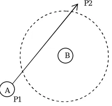
Individually, the role of MP might not be enough for keeping a correct local topology. The example shown in illustration 2 indicates where node A shifts from p1 to p2 at a consistent speed and power. At present, suppose that node A has now issued a signal when on p1. Because node B did not get this packet, it is oblivious of the presence of node A. Additionally suppose that ARE is adequately big enough that while node A shifts from P1 to P2, the rule of MP is not activated. Conversely, in figure 2 node A is inside the contact field of B for an important part of its movement. Still, neither B nor A can be aware of one another. At present, in circumstances where neither of the nodes is broadcasting information packets, this can be considered a harmless situation, as far as they
are not inside a communicating field when A arrives at P2. Yet, if any of A or B were broadcasting information data packets, then their home topology would not be kept up to date and both will leave each other, when choosing the subsequent hop node. In the most unpleasant condition, if there were no extra nodes around, the information packets would not be broadcasted at all.
Fig. 2. An example illustrating a drawback of the MP rule.
Thus, it is imperative to develop a system, which can uphold a more exact topology in those places of the set-up where important information forwarding operations are taking place. This is exactly what the On-Demand Learning method targets to attain. As the title shows, a node transmits signals when a demand is on, i.e., in reply to data forwarding action that happens in the locality of that node. Depending on this rule, every time a node to information broadcast from a fresh neighbour, it transmits a signal as a reply. The term new neighbour means a neighbour, which is not yet included in the list of neighbours of this node. As a matter of fact, a node exploits a short accidental intermission prior to acting in response with the signal to avoid crashing with other signals. Remember that, we had supposed that site updates take the credit of the information packets and every node operates in the loose manner, which lets these to respond to the information packets broadcasted in their locality. Moreover, As far as the information box comprises of the position of the ultimate goal, every node that responds to an information box also looks for its recent position and finds out if the goal is inside its area of broadcast. In case of a positive discovery, the targeted node is included to the nodes neighbours’ list if it did not yet exists there. Observe that this especial confirmation costs nothing, i.e., no signals are required to broadcast.
( Xl , Yl)
(Xp , Yp)
Vx
Vy
A
B
P1
P2
ISSN: 2231-5381
http://www.ijettjournal.org
Page 423 We call the refined list of neighbours at anode ‘The Starting Point’ and the list of MP ‘The Fundamental List’. This list is refined in reaction to the movement of the node and its surrounding bodies. The ODL rule permits those nodes which are concerned with forwarding information to enhance their topology further than their initial set. Similarly, an enhanced list is prepared at the nodes situated in the area of more traffic pressure. Hence, the enhanced list is set only at the mobile nodes and is constructed in reaction to the system’s traffic. The initial list of neighbours is managed by the immobile nodes only. By managing an improved list of neighbours alongside the forwarding path, ODL makes sure that in circumstances when the nodes busy in forwarding information are actively moving, substitute paths can effortlessly be built without causing more postponement.
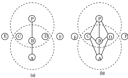
The figure 3a shows the system’s topography prior to when node A begins issuing information to node P. The prominent lines in the figure show that both sides of the linkage are conscious of each other. The starting route available from A to P is A-B-P. At present, when A issues information packets to B, both C and D get information packets from A.
Fig. 3. An example illustrating the ODL rule
Being a new acquaintance of C and D, A receives signals both from C and D according to the rule of ODL. Consequently, connections AC and AD will appear. Additionally, depending on the position of the goal and their recent locality, C and D find out information that the goal P is inside their one-leap vicinity. Likewise, when B onwards information Packets to P, the connections BC and BD are formed. Diagram 3b reveals the enhanced Physiographic alongside the route of A to P. Observe that, although E and F sent signals from C
and D, correspondingly, none of the two answers with a signal. As far as C and D are not positioned on the forwarding route, it is useless for both to reply with signal updates to the transmissions from C and D. In short, ODL targets to enhance the aptness of topology for the sake of every traffic course alongside the routing line from the starting place to the ending point.
III. FORWARDINGNODESELECTION
From the (Vx, Vy)value of the nodes in the
neighbour table list, all the mobility values are listed and while selecting the forwarding nodes; only those which are in the direction of the destination node as in the GPSR scheme are contended. These nodes are sorted according to their mobility and the median node is selected and choosed as the forwarding node. In the similar manner all the forwarding nodes are selected up to the destination node by keeping in another constraint of having the minimum hop count. Thereby the occurrence of link failures is drastically minimised and the efficiency of the system is scaled up along with the energy conservation factor.
IV. SIMULATIONRESULTS
From the graph it can be clearly seen that the energy consumption after the same amount of data transmission under the periodic uniform beacon update system was 74%. Secondly a node retained 88% of the energy when the same amount of data was transmitted with the APU system, whereas a forwarding node conserved up to 92% of its energy when transmitting under our system of implementation. Thereby it shows that our system is highly energy conservative, which is the vital necessity of the current hour.
P
C B
A D
E F
A B
C D
E F P
(a) (b)
100
95
90
85
80
75
1 2 3 4 5 6 7 8 9 10 ENERGY
TIME Mobility Based
APU
ISSN: 2231-5381
http://www.ijettjournal.org
Page 424V. CONCLUSION
In this paper, we emphasise the need for mobility based forwarding node selection in the existing geographic routing strategies. According to the APU scheme each node updates its position and mobility corresponding to two of its rules namely MP and ODL. Finally by choosing the nodes with median mobility for forwarding, we achieve high energy efficient system and the end to end delay is drastically reduced thus enhancing the overall performance of the system. In the future work, source and destination nodes mobility can also be counted in and the efficiency of the system can be further enhanced.
REFERENCES
[1] Quanjun Chen, Salil S. Kanhere and Mahbub Hassan, “ Adaptive Position Update for Geographic Routing in Mobile Ad Hoc Networks” IEEE Transactions on Mobile Computing, Vol. 12, No. 3, March 2013
[2] J. Hightower and G. Borriello, “Location Systems for Ubiquitous Computing,” Computer, vol. 34, no. 8, pp. 57-66, Aug. 2001.
[3] B. Karp and H.T. Kung, “GPSR: Greedy Perimeter Stateless Routing for Wireless Networks,” Proc. ACM MobiCom, pp. 243-254, Aug. 2000.
[4] L. Blazevic, S. Giordano, and J.-Y. LeBoudec, “A Location Based Routing Method for Mobile Ad Hoc Networks,” IEEE Trans. Mobile Computing, vol. 4, no. 2, pp. 97-110, Mar. 2005.
[5] Y. Ko and N.H. Vaidya, “Location-Aided Routing (LAR) in Mobile Ad Hoc Networks,” ACM/Baltzer Wireless Networks, vol. 6, no. 4,pp. 307-321, Sept. 2002.
[6] T. Camp, J. Boleng, B. Williams, L. Wilcox, and W. Navidi, “Performance Comparison of Two Location Based Routing Protocols for Ad Hoc Networks,” Proc. IEEE INFOCOM, pp. 1678-1687, June 2002.
[7] D. Johnson, Y. Hu, and D. Maltz, The Dynamic Source Routing Protocol (DSR) for Mobile Ad Hoc Networks for IPv4, IETF RFC 4728, vol. 15, pp. 153-181, Feb. 2007.
[8] C. Perkins, E. Belding-Royer, and S. Das, Ad Hoc On-Demand Distance Vector (AODV) Routing, IETF RFC 3561, July 2003.
[9] J. Li, J. Jannotti, D.S.J.D. Couto, D.R. Karger, and R. Morris, “A Scalable Location Service for Geographic Ad Hoc Routing,” Proc. ACM MobiCom, pp. 120-130, Aug. 2000.
[10] Z.J. Haas and B. Liang, “Ad Hoc Mobility Management with Uniform Quorum Systems,” IEEE/ACM Trans. Networking, vol. 7, no. 2, pp. 228-240, Apr. 1999.
[11] A. Rao, S. Ratnasamy, C. Papadimitriou, S. Shenker, and I. Stoica, “Geographic Routing without Location Information,” Proc. ACM MobiCom, pp. 96-108, Sept. 2003.
[12] S. Lee, B. Bhattacharjee, and S. Banerjee, “Efficient Geographic Routing in Multihop Wireless Networks,” Proc. ACM MobiHoc, pp. 230-241, May 2005.
[13] Q. Chen, S.S. Kanhere, M. Hassan, and K.C. Lan, “Adaptive Position Update in Geographic Routing,” Proc. Int’l Conf. Comm. (ICC ’06), pp. 4046-4051, June 2006.