The Active River Area
A Conservation Framework for Protecting Rivers and Streams
support helped to shape and inform this document. Special thanks go to Mike Kline (Vermont
Agency of Natural Resources), Mark Anderson (TNC) and Jonathan Higgins (TNC), each of
whom contributed significant ideas and information integral to the material we present. We
would also like to thank Colin Apse, Michele DePhilip, Steve Haase, Kim Lutz, Jeff Opperman,
Daryl Peterson, and Josh Royte for their often detailed comments at various times during the
development of this report. Also, thank you to Charles Ferree (TNC) for support with the
mod-eling, Rita Thanos (TNC) for tracking down the needed permissions and approvals, Jason
Williams (MMI) for his illustration of the active river area components, and to Scott Hancock
(Hancock Design) for designing this report. Finally, we want to acknowledge and thank the
Sarah K. de Coizart Charitable Trust, without whose generous support this project would not
have been possible.
Prepared with support from: Milone & MacBroom, Inc. 1233 Shelburne Road, Suite 150 South Burlington, Vermont 05403
Funding for this project provided by the Sarah K. de Coizart Charitable Trust
April 2008
This report was jointly prepared by
Mark P. Smith (TNC), Roy Schiff (MMI),
Arlene Olivero (TNC), and James MacBroom (MMI)
The Nature Conservancy Eastern U.S. Freshwater Program 11 Avenue De Lafayette, 5thFloor
Boston, MA 02111 USA www.nature.org
TABLE OF CONTENTS
Chapter 1 Introduction . . . 1
The Active River Area as a Basis for Action . . . 1
Document Overview . . . 2
Chapter 2 Defining the Active River Area. . . 3
Linking Ecology and River Processes . . . 3
Components of the Active River Area. . . 4
Dominant Processes and Attributes. . . 6
Watershed Position . . . 10
Active River Area Components and Watershed Position . . . 11
Watersheds as a Nested Framework . . . 17
Chapter 3 Services from Functioning Active River Areas. . . 20
Other Habitat Values . . . 20
Avoidance and Reduction of Flood and Erosion Hazards . . . 21
Adapting to Climate Change . . . 22
Water Quality Protection . . . 22
Recreation Opportunities. . . 23
Open Space . . . 23
Chapter 4 Delineating the Active River Area. . . 25
Delineating the Active River Area . . . 25
Model Verification . . . 26
Case Study: Connecticut River Example. . . 27
Subwatershed and Reach Delineations . . . 29
Chapter 5 Assessing the Active River Area . . . 32
Stream Corridor Restoration. . . 32
Habitat Assessment . . . 33
Geomorphic Assessment. . . 34
Biomonitoring . . . 35
Chapter 6 Protecting River Processes. . . 37
Complementary to Other Freshwater Conservation Strategies . . . 37
Freshwater Conservation Planning. . . 38
Designing Freshwater Protected Area Networks . . . 38
Improving River Policies and Programs . . . 40
Chapter 7 Using Active River Area Concepts for Restoring River Processes . . . 42
Restoration of River and Active River Areas . . . 45
Stressor Identification . . . 45 Restoration Approaches . . . 45 Design Approaches . . . 46 Chapter 8 Conclusion. . . 48 Appendix A. . . 49 Citation Information:
Smith, M.P., Schiff, R., Olivero, A. and MacBroom, J.G., 2008. THE ACTIVE RIVER AREA: A Conservation Framework for Protecting Rivers and Streams. The Nature Conservancy, Boston, MA.
Freshwater systems are among the most biologically diverse and rich systems in the world (Decamps, 1997; Master et al., 1998). This richness and diversity is in large part a result of the highly dynamic nature of river systems which creates a mosaic of shifting habitat types that vary in age, species composition, and structure and provide a broad range of natural conditions around which the life cycles of species and natural communities have evolved (Ward et al., 2002). Since the rich and unique biodiversity values of rivers are related to the dynamic nature of these systems, effective river conservation must include the protection of key physical and ecological processes. These processes are driven in large part by the movement of water and the associated movement of sediment, energy, materials and organisms. They are also driven by energy inputs to these systems, including the contribution of organic and other materials that provide the foundation on which the web of life within these systems is built.
River health depends on a wide array of processes that require dynamic interaction between the water and land through which it flows. The areas of dynamic connection and interac-tion provide a frame of reference from which to conserve, re-store and manage river systems. We choose the term active river areato define this framework. “Active” indicates the dynamic and disturbance-driven processes that form and maintain river and riparian systems and their associated habitats and habitat conditions. “River area” represents the lands that contain both of aquatic and riparian habitats and those that contain processes that interact with and contribute to a stream or river channel. The active river areaframework offers a more holistic vision of a river than solely considering the river channel as it exists in one place at one particular point in time. Rather, the river becomes those lands within which the river interacts both frequently and occasionally.
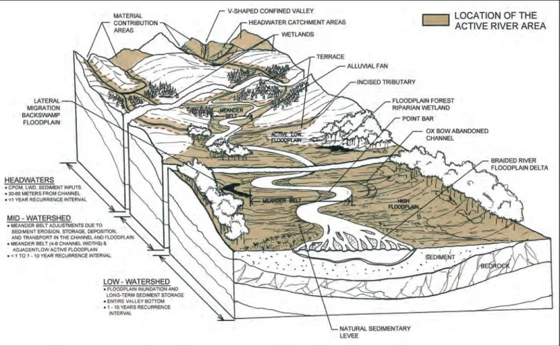
The active river areaprovides a systematic means for concep-tualizing and protecting the river as a dynamic system with a broad range of conditions that are typical of natural river systems. The active river areais spatially explicit and can be readily identified – narrow in some areas, wider in others – and captures the living, dynamic processes and places that define these systems. The active river area includes a number of distinct components which provide specificity to guide actions for protection, restoration and manage-ment (Figure 1.1).
The Active River Area as the Basis for Action The understanding of the importance of riparian lands and floodplains as integral to rivers and river health is not new. Naiman, et al. (1993) describe in great detail these impor-tant functions and values:
Planning based on isolated components (e.g., fish, vegetation, or restoration of specific stream sections) is ecologically incomplete. Consideration must be given to maintaining hydrologic connectivity and variability of riparian corridors from the head-waters to the sea. This means that better riparian corridor protec-tion must take place in the numerous headwater streams as well as in the broad floodplains downstream. (Naiman et al., 1993).
The active river areais designed to answer this call by provid-ing a spatially-explicit framework based on watershed position and key geomorphic components to provide a tool to inform conservation, restoration and management. The framework provides a means to broaden work on river conservation that often focuses almost solely on individual instream processes like sedimentation or on protecting vegetated buffer strips in order to mitigate the water qual-ity impacts of agriculture, urbanization and other human land uses. The framework also provides the context for mitigating the long legacy of efforts to control and harness
CHAPTER 1: INTRODUCTION
“Riparian corridors possess an unusually diverse array of species and environmental processes. This "ecological" diversity is related to variable flood regimes, geomorphic channel processes, altitudinal climate shifts, and upland influences on the fluvial corridor. This dynamic environment results in a variety of life history strategies, and a diversity of biogeochemical cycles and rates, as organisms adapt to disturbance regimes over broad spatio-temporal scales. These facts suggest that effective riparian management could ameliorate many ecological issues related to land use and environmental quality. We contend that riparian corridors should play an essential role in water and landscape planning, in the restoration of aquatic systems, and in catalyzing institutional and societal cooperation for these efforts.” (Naiman et al., 1993)
rivers and to cultivate and settle the fertile floodplains and riparian lands they create. These efforts disrupt the natural processes and disconnect rivers from their riparian lands and floodplains with a cascading series of impacts (Burcher et al., 2007) that threaten river and riparian habitat and the broad range of benefits that thesee areas provide. The active river areaframework adds an important approach to efforts to protect and restore natural hydrologic regimes, restore and maintain connectivity within and along rivers, and mitigate other threats such as pollution sources, invasive species, over-harvest of fish and other resources, mineral and material extraction, and the conversion of riparian areas to other land uses. Without the protection and restoration of key physical and ecological processes and the areas within which they occur, efforts to protect rivers are likely to fall short of their goals and expectations. Healthy rivers also provide a broad range of other social and economic benefits to society as discussed in Chapter 3. Document Overview
Chapter 2 of this document describes the five components
of the active river area, and the dominant physical processes and habitat values associated with each of these compo-nents. Chapter 3 describes the broad range of ecosystem services gained by society by having active river areas maintain most of their natural features and conditions, including re-ducing flood and erosion risks to human infrastructure, water quality protection and recreation opportunities. Chapter 4 describes approaches to delineating the active river areaat various scales and provides a case study of an ap-proach for the Connecticut River watershed. Chapter 5 provides a list of existing assessment protocols that can help provide more detailed evaluations of the condition of
active river areas as the basis for protection, restoration and management actions. Chapter 6 describes how the active river areacan be used as the basis for designing protected area networks, for informing river restoration activities and informing river management programs and policies. Chapter 7 presents an overview of how the active river area
framework forms an approach to identifying and planning on-the-ground restoration projects. Chapter 8 provides a short conclusion to the paper.
Introduction
The active river areaframework is a spatially explicit, holistic view of rivers that includes both the channels and the ripar-ian lands necessary to accommodate the physical and ecological processes associated with the river system. The framework informs river conservation by providing an approach to account for the areas and processes that form, change and maintain a wide array of habitat types and conditions in and along rivers and streams (Table 2.1). Linking Ecology and River Processes
Dynamic processes collectively form, disturb, and maintain different habitat components over a range of spatial and temporal scales (Steinman and Denning, 2005; Lowe et al., 2006). Research continues to reveal the many fundamen-tal links between physical processes, aquatic, riparian, and wetland habitat, and aquatic biota in rivers and streams (e.g., Booker, 2003; Clarke et al., 2003; Coulombe-Pont-briand and LaPointe, 2004; Sullivan et al., 2004a; Sullivan et al., 2004b). To maintain rivers and stream ecosystems in a naturally functioning and sustainable state we need an integrated approach that considers the processes and attributes of flow and sediment regimes, physical habitat structure, water quality, energy source and transfer, and
CHAPTER 2: DEFINING THE ACTIVE RIVER AREA
“Ecologically effective ecosystem manage-ment will require the developmanage-ment of a robust logic, rationale, and framework for addressing the inherent limitations of scientific under-standing. It must incorporate a strategy for avoiding irreversible or large scale environ-mental mistakes that arise from social and political forces that tend to promote frag-mented, uncritical, short-sighted, inflexible, and overly optimistic assessments of resource status, management capabilities, and the consequences of decisions and policies.” (Frissell and Bayles, 1996)
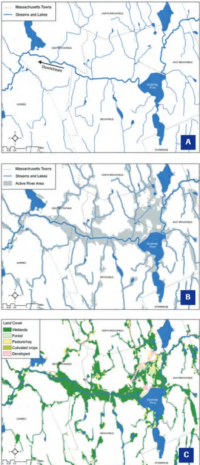
Figure 2.1 – Active river area:Quaboag River and Pond, MA: (A) Pond and channel; (B) Including the active river area,
(3) with land cover showing the active river area as predominantly wetlands.
A
B
biological interactions (Karr and Dudley, 1981; Karr and Chu, 1999; Mattson and Angermeier, 2007).
By explicitly considering processes such as system hydro-logic connectivity (Pringle, 2001), floodplain hydrology (Booth et al., 2006), and sediment movement along the river corridor (Steiger et al., 2005), the active river area
framework identifies places where these processes occur. The framework provides a systematic approach to identi-fying these areas based on valley setting, watershed position and geomorphic stream type and can be used to identify conservation targets and guide the management of fresh-water resources.
Components of the Active River Area
We identify five primary components of the active river area: 1) material contribution areas; 2) meander belts; 3) flood-plains; 4) terraces; and 5) riparian wetlands. These areas are defined primarily by the type and frequency of inter-action with the river. These areas often overlap – for exam-ple, many floodplains include extensive riparian wetlands
and meander belts usually include parts of the low flood-plains. But they can also be distinct – for example, headwa-ter streams in confined valleys may include narrow maheadwa-terial contribution areas with limited nearby floodplain. We describe the active river areaframework by first describ-ing these five components, then discussdescrib-ing the dominant physical processes that drive these systems and describing how these processes can generally be characterized relative to their position in the watershed. As part of this descrip-tion we identify how these processes and components to-gether form and maintain the rich mosaic of habitat types and conditions that exist in rivers and riparian lands (see Table 2.2 on page 18).
1) Material Contribution Areas
Headwater areas and certain upland areas directly adjacent to the stream channels regularly contribute significant amounts of material, both organic and inorganic, to river and stream systems. We identify two types of material con-tribution areas. The first are the small headwater water-Natural Processes/
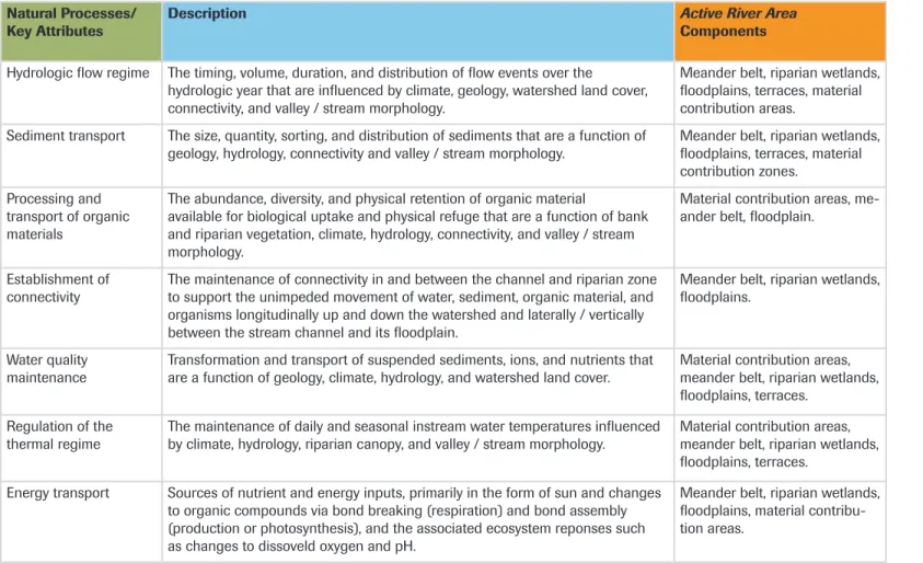
Key Attributes Description Active River AreaComponents
Hydrologic flow regime The timing, volume, duration, and distribution of flow events over the hydrologic year that are influenced by climate, geology, watershed land cover, connectivity, and valley / stream morphology.
Meander belt, riparian wetlands, floodplains, terraces, material contribution areas.
Sediment transport The size, quantity, sorting, and distribution of sediments that are a function of
geology, hydrology, connectivity and valley / stream morphology. Meander belt, riparian wetlands,floodplains, terraces, material contribution zones.
Processing and transport of organic materials
The abundance, diversity, and physical retention of organic material
available for biological uptake and physical refuge that are a function of bank and riparian vegetation, climate, hydrology, connectivity, and valley / stream morphology.
Material contribution areas, me-ander belt, floodplain.
Establishment of
connectivity The maintenance of connectivity in and between the channel and riparian zone to support the unimpeded movement of water, sediment, organic material, and organisms longitudinally up and down the watershed and laterally / vertically between the stream channel and its floodplain.
Meander belt, riparian wetlands, floodplains.
Water quality
maintenance Transformation and transport of suspended sediments, ions, and nutrients that are a function of geology, climate, hydrology, and watershed land cover. Material contribution areas, meander belt, riparian wetlands, floodplains, terraces.
Regulation of the
thermal regime The maintenance of daily and seasonal instream water temperatures influenced by climate, hydrology, riparian canopy, and valley / stream morphology. Material contribution areas, meander belt, riparian wetlands, floodplains, terraces.
Energy transport Sources of nutrient and energy inputs, primarily in the form of sun and changes to organic compounds via bond breaking (respiration) and bond assembly (production or photosynthesis), and the associated ecosystem reponses such as changes to dissoveld oxygen and pH.
Meander belt, riparian wetlands, floodplains, material contribu-tion areas.
sheds in the uppermost reaches of the watershed where stream channels are first formed. These headwater areas are important sources of the organic and inorganic mate-rials which serve as the basic building blocks for the food web of the stream system. It is within these small water-sheds that1st order streams are formed from overland flows, intermittent and zero order streams and gullies, and from springs (Hack and Goodlett, 1960; Gomi et al., 2002). For this reason, and because mapped streams have been found to under represent the presence and role of streams in these areas (Gomi et al., 2002), we use small watersheds to define these areas (Figure 2.2). These head-water areas have been shown to have a long-term influence on channel morphology (Davies et al., 2005) and thus aquatic habitat locally and downstream.
The second type of material contribution areas is the up-land areas immediately adjacent and along rivers and streams that are not a floodplain, terrace or riparian wet-land. These are generally upland areas along steep banks, bluffs or other situations that limit out-of-bank of river flows but where these areas contribute materials, shade and other structural features to the river. We have define these as areas within 30 to 50 meters of the stream channel as studies have found that large woody debris and other or-ganic materials in rivers and streams generally originates from areas within this distance from the stream channel (May and Gresswell, 2003; Webb and Erskine, 2003). The contribution of materials also occurs within meander belts, floodplains, terraces and riparian wetlands and is one of many functions of these other active river areacomponents.
2) The Meander Belt
The meander belt is the area within which the channel or channels will migrate or ‘meander’ over time and repre-sents the most active part of the active river area. The mean-der belt width is defined by the cross-channel distance that spans the outside-most edges of existing or potential me-anders (Figure 2.3). The width of the meander belt can be readily calculated and mapped for healthy and altered rivers, thus providing a reference template on which to base protection and restoration decisions. Channels and banks are part of the meander belt and thus not considered separately.
3) Floodplains
Floodplains are generally expansive and low slope areas, often with multiple channels and deep deposits of sedi-ments and other materials. Nanson and Croke (1992) de-fine floodplains as “the largely horizontally-bedded alluvial landform adjacent to a channel, separated from the channel by banks and built of sediment transported by the present flow-regime. They describe three generic types of flood-plain based on stream power (high, medium or low) and alluvial cohesiveness (cohesive = silt and clay; non-cohesive = sands to gravels): 1) high energy non-cohesive flood-plains that erode in response to extreme episodic events and generally found in headwaters and other confined areas; 2) medium energy non-cohesive floodplains formed by regular flows across broad valleys where erosion is a function of sediment texture; and 3) low-energy cohesive floodplains formed by regular flows across broad valleys but with more stabilize banks of erosion resistant materials (Table 2.3).
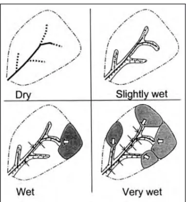
Figure 2.2 – “Conceptual view of dynamic, hydrologically active areas in headwaters. For dry conditions, riparian zones and direct precipitation on channels are the only active sites of flow generation. Throughflow from the soil matrix at the foot of hillslopes and riparian areas gradually activates with increasing wetness. Zero-order basins (shaded areas) with relatively shallow soils begin to contribute surface runoff (broad white arrows) during wet conditions, while preferential flow (thin black arrows) from hillslopes contributes less to stream flow. Water begins to flow in transitional channels emerging from zero-order basins. Zero-order basins and preferential flow actively contribute to storm flow during very wet conditions” (From Sidle et al., 2000; Gomi et al., 2002). (Copyright American Institute of Biological Sciences.)
We describe floodplains as either low or high floodplains. Low floodplains are generally immediately adjacent to the river or stream and are inundated by river flows on a regu-lar basis (e.g., annually). Low floodplains overlap with the non-channel portions of the meander belt and tend to flood even during moderate storms. High floodplains are at a slightly higher elevations and are also inundated on a reg-ular, yet less frequent basis (e.g., every 1 – 10 years).
4) Terraces
Terraces are former floodplains from when the river was flowing at higher levels (Ward 2002). Terraces typically are deposited materials from large landscape forming events such as uplift or glacial retreat. They may still be inundated rarely and may, depending on local conditions, continue to support natural communities of floodplain species such as floodplain forests. Terraces can have important roles in
temporarily storing waters during very large flood events (e.g., 20-100 year floods).
5) Riparian Wetlands
Riparian wetlands are generally low-gradient areas with in-undated or hydric soils that support wetland plant species. Soil inundation is a result of either adjacent stream and river water levels or as a result of high groundwater levels, or both. There are a wide range of wetland types that might exist in these areas, often depending on local geology, land-scape position, and climatic conditions. Riparian wetlands are typically areas of high plant diversity and serve impor-tant aquatic and terrestrial habitat functions (Table 2.4). Dominant Physical Processes and Attributes The physical processes and key attributes described below are key drivers of riverine and riparian habitat formation, habitat conditions and of their ecological integrity. River and riparian habitat is constantly being cated, changed, destroyed, and maintained as a re-sult of the processes associated with the hydrologic regime, sediment transport, and or-ganic and inoror-ganic material processing (Table 2.5). Such changes may occur within a dynamic ‘equilibrium’ where a natural balance is main-tained with some range of natural variability. “Habitat equilibrium” can be described as the bal-ance of habitat type and abundbal-ance and its for-mation and maintenance by physical and ecological processes. For stream channels this Figure 2.3 – (A) A schematic showing the meander belt width, as well as the channel length (CL) and the valley length (VL) used to get the channel sinuosity (CL/VL) (City of Austin Texas Watershed Protection and Stream Restoration Program and Ayres Associates, Fort Collins, CO).(B) A photo of a large meander belt in a broad valley setting on the Red River in Manitoba, Canada. Note the common variations in local meander belt width towards the top of the photograph. (Reproduced with the permission of Natural Resources Canada 2008, courtesy of the Geological Survey of Canada).
Low Energy Medium Energy High Energy
Dynamics slow, inactive gradual activity extremely active Flood Frequency 1-5 years 1-5 years >25 years Stream Power (ft-lbs/sec) <20 20-400 >400 Dominant Accre-tion Process vertical fine strata
lateral point bar or braided coarse vertical Dominant Sediment cohesive, clay to sand
sand to gravel coasre sand to cobble
Table 2.3 Floodplain Classification (adapted from Nanson and Croke, 1992)
equilibrium is analogous to and closely tied to the known balance between water and sediment (Figure 2.4).
It is important to note that river equilibrium is not a static condition for the channel or other fea-tures. Rather it is an equi-librium within which rivers are expected to change (Schumm, 1994). The equilibrium of rivers
changes over very long time scales (e.g., adjustment as a re-sult of climate change such as glacial retreat or global warming), medium time scales (e.g., recovery from land use disturbance such as widespread logging in a watershed), and very short time scales (e.g., response to severe events such as floods and landslides). This understanding of ‘dy-namic equilibrium’ helps inform the overview of the fol-lowing key processes.
Hydrology
Hydrology has been described the master variable influ-encing the physical processes and attributes in aquatic ecosystems (Poff et al., 1997). Natural water flows consist of a broad range of flows, from floods to droughts, with variation of several orders of magnitude between the vol-umes of low flows to those of flood flows. The natural vari-ation in magnitude, frequency and durvari-ation of these flows are essential for preserving the ecological integrity of fresh-water systems (Sparks et al., 1990; Richter et al., 1998) and these water flows directly influence physical habitat, life cycle strategies, connectivity, and species composition (Bunn and Arthington, 2002).
The characteristics of these flows are determined, in large part, as a result of slope, form, and composition of the lands through which the water flows. Hydrology, along with sed-iment regime, and valley / channel morphology, determines the hydraulics of rivers – that is the combinations of water depth and velocity. The continuity equation Q = V * A (where Q is discharge, V is water velocity and A is the cross-sectional flow area) indicates that for a given dis-charge velocity will be lower for larger cross sectional flow areas. This fundamental theory is important for under-standing the different hydrologic regimes between
channels in confined and unconfined valleys and the im-portance of out-of-bank flows and of access to floodplains, riparian wetlands and other areas for maintaining the nat-ural range of conditions. At the scale of the valley floor, out of bank and floodplain access increases cross-sectional flow area so water velocity during floods is lower for unconfined streams across the entire valley. At the scale of the bankfull channel, hydraulics can be quite variable due to a varied shape of the channel bottom where benches and low-flow channels change the cross-sectional flow area during dif-ferent flow conditions.
A related concept is stream power φ = γ* Q * S (where φis the stream power, γis the specific weight of water, Q is the discharge and S is the slope of the water surface assuming normal flow) which is the ability of the flowing water to do work or cause erosion. Stream power is a function of hy-drology and channel morphology. In very broad valleys when water spills onto a floodplain, the slope of the water surface tends to be lower over the floodplain than in the channel, which in turn reduces erosion. For smaller valley widths, velocities are higher and the slope tends to be more uniform across the channel and floodplain so more erosion tends to take place.
Sediment Transport
Sediment transport is an important driver of physical processes and habitat formation in river and riparian ecosystems. Sediment transport and watershed hydrology collectively determine the dynamic equilibrium for alluvial channels (Lane, 1955). Sediment is continually moving through stream and river channels as source material is moved from headwaters, deposited, and eroded in mid-watersheds, and eventually deposited in the lower water-Table 2.4 Functions of Riparian Wetlands (Brinson et al., 1995)
Hydrologic Biogeochemical
Dynamic Surface Water Storage Nutrient Cycling
Long-Term Surface Water Storage Removal of Imported Elements and Compounds
Energy Dissipation Retention of Particulates
Subsurface Storage of Water Organic Carbon Export Moderation of Ground Water Flow or Discharge
Plant Habitat Animal Habitat
Maintain Characteristic Plan Communities Maintain Spatial Structure of Habitat Maintain Characteristic Detrital Biomass Maintain Interspersion and Connectivity
Maintain Distribution and Abundance of Invertebrates Maintain Distribution and Abundance of Vertebrates
shed before finally being transported to the ocean. Large infrequent sediment input events such as landslides, most common in the upper watershed, can influence the down-stream channel network for extended periods of time as sediment is continually deposited and re-suspended. More frequent flow events, such as bankfull flows that typically have a recurrence interval of about 1.5 years, effectively transfer sediment downstream and therefore play a major role in dictating channel pattern (Wolman and Miller, 1960). Excessively high or low amounts of sediment can
change stream hydrology and disrupt the natural dynamic equilibrium between hy-drology and sediment and result in either excessive sediment erosion or in exces-sive sediment storage and deposition. Either situation fundamentally alters the sediment load in the river or stream and can lead to widespread changes in the shape and location of the channel. Through the process of being moved downstream, the sediment is sorted by particle size with different particle sizes being deposited in different locations. The distribution of these different mate-rial types establish important scour and deposition areas and with them, varying habitat types and conditions. These fea-tures in turn form hydraulic units such as steps, pools, and riffles that support dif-ferent species throughout their life-cy-cles. Therefore, altering the sediment regime not only disrupts channel stability, but also can impair habitat. For example, excessive sedimentation that coverts a riffle-pool stream type to a uniform plane bed channel can reduce habitat sta-bility and homogenize the channel bed, changing a cobble or gravel substrate to a substrate to a silt or embedded substrate. Hydrology and sediment regimes funda-mentally work together to create and maintain habitat.
Transport and Transformation of Organic and Inorganic Materials
Organic materials such as coarse particu-late organic matter (CPOM), large woody debris (LWD), and inorganic ma-terials, such as minerals, constitute the building blocks of life in rivers and riparian areas. These inorganic and or-ganic materials are the ‘energy’ on which the web of life in the river and riparian systems are built. In headwater areas and small streams, riparian areas are the primary source of these materials. In medium and large rivers, the primary source of these organic and inorganic materials is from up-stream (Vannote et al., 1980) rather than the immediately surrounding riparian areas.
Table 2.5 Typical Habitat Features of Active River AreaComponents
Active River AreaComponent Typical Habitat Features
Material contribution areas Seep or saturated source area Spring
Wetland (forested, meadow, etc.) Forest canopy / overhanging vegetation Bluff, cliff and steep slopes
Meander belt Step, riffle, run, pool, glide, dune, ripple
Sediment & gravel bars (point, mid-channel, etc.) Hydraulic refugia from tributaries and oxbows Undercut bank
Beaches and scour areas
Physical refugia from LWD, debris jam, CPOM Forest canopy / overhanging vegetation
Floodplain Oxbows Meander scar Floodplain lake Wetland Backwater swamp Island Natural levee Floodplain forest
Forest canopy / overhanging vegetation Clay plug (filled oxbow)
Terraces Wet meadow
Ridges (old natural levee) Troughs (dry oxbow) Meander scars Prairie
Remnant floodplain forest Riparian wetlands Forested, meadow, etc.
Vernal pool Backwater swamp Beaver pond flowage
In addition to serving as the raw material for aquatic life, some materi-als, such as large woody debris (LWD), have pro-found physical effects on river processes such as sed-iment transport (Waller-stein and Thorne, 2004), local hydraulics (Daniels and Rhoads, 2004) and retention of CPOM (Al-louche, 2002). LWD plays important roles in dictat-ing the local sediment regime, increasing hy-draulic diversity, and influ-encing the abundance and dominant feeding mecha-nism of aquatic orgamecha-nisms (Nislow and Lowe, 2006). Watershed topography, stream size, tree species, and tree size influence the amount of LWD inputs (May and Gresswell, 2003; Webb and Erskine, 2003). This processing of inor-ganic and materials is a key ecological process for river
systems and depends on the hydrology and sediment regimes of a river or stream and the interaction of these physical processes with the surrounding riparian areas and with in-channel conditions.
Connectivity
One key attribute necessary to allow the processes associ-ated with hydrology, sediment transport, and the transfor-mation of organic and inorganic materials in river and riparian systems is the existence of connections within river systems – both up and down channels and between chan-nels and riparian areas and floodplains. Longitudinal con-nections up and down the channel allow the movement of organisms between habitats and affects the movement of water, sediment and organic materials (Pringle, 2001). Lateral and vertical connectivity between the channel and
floodplain has a strong in-fluence on hydrologic and sediment regimes both within the river and on the floodplain and thus are an important component of both channel stability and aquatic habitat. Flood stor-age, sediment deposition and nutrient uptake are all important processes that require good connectivity between the channel and floodplain (Noe and Hupp, 2005).
These connections are often driven by hydrologic events. High water seasons are often associated with the migration of fish and other species that take ad-vantage of these high flows to move up and down rivers and streams to areas not accessible during lower flows. Resident fish may also move into floodplain features during high flows to seek refuge (Schwartz and Herricks, 2005). Floodplain connections between different parts of the floodplain and between the floodplain and the channel can be sporadic, occurring frequently in the low floodplain and less frequently for higher areas of the floodplains. These flow events temporarily link important habitat areas like oxbow lakes and backswamps with the river and other wet-land areas that are used for refuge, spawning, and nursery grounds (Hohausova and Jurajda, 2005). These tempo-rary connections allow both the movement of species be-tween these areas but also, during times when the hydrologic connection is not present, provide isolated areas that may have standing or slow moving, warmer, and less turbid waters than the river. In addition, these isolated water bodies are often free from some predators, making them important nursery and specialized habitat types.
Figure 2.4 – Schematics illustrating the equilibrium and disruption of the balance between water and sediment leading to aggradation or erosion (From Ontario Ministry of Natural Resources (OMNR), 2001).
Water Quality, Temperature, and Energy Transport
The processes that occur within the active river areain com-bination with the geology, climate, and vegetation together create the background water chemistry of rivers and ripar-ian areas, including acidity, suspended sediments, nutrients, and metals (Hynes, 1975). The resultant water quality in-fluences all stream habitat as well as the biological processes that take place in the channel.
Water temperature is a product of the amount of solar ra-diation reaching the water surface through the vegetative canopy and the abundance and temperature of ground-water and upstream inputs. Together with the concentra-tion of organic matter, the sunlight governs the amount of photosynthesis and respiration (energy transfer) taking place as organic compounds are assembled and simplified. The energy transfer influences the concentration of dissolved oxygen, rates of organic material processing, and nutrient uptake.
Watershed Position
The interaction and relative importance of these physical and ecological processes and key attributes can be more specifically understood in the context of their position within the watershed. A watershed is often described as having three parts--headwater/source areas, mid-water-shed/transfer areas, and lower watershed/deposition areas (Figure 2.5) (Schumm, 1977; Vannote et al., 1980). These divisions provide an idealized structure to understand the key processes of hydrology, sediment transport, connectiv-ity, transport and transformation of organic and inorganic materials, and water quality. Here we use Schumm’s system (1977) to organize the active river area components with channel characteristics, dominant processes, key ecological attributes, important ecological processes and habitat features (Table 2.6).
It is important to note that across the landscape river systems often deviate from this idealized model of steep
Watershed Position and Process1 Headwaters, source Middle, transfer Lower, deposition
Stream Type Straight, steep, narrow,
hillslope/debris Straight/meandering, wide, fluvial Meandering, flat, very wide Floodplain Connection Non-existent or local to channel Local to channel or wide,
important connection
Wide, important connec-tion
Typical D50 Boulders, bedrock,
cobbles Cobbles, gravels, sands, boulders Sands, silts, gravels
Table 2.6 Dominant Process and Disturbance Regime Based on Valley Setting, Watershed Position and Geomorphic Stream Type
General Description of Location*
Confined to narrow valley
Broad valley
Stream Type5 Bedrock/
Cascade Step-Pool Riffle-pool Plane bed Braided/Multi** Dune-ripple
Rosgen Classification6 A A, B B, C B, C, other D, D
A E, F
Geomorphic Classification*
Process LWD, CPOM, and sediment
inputs accommodate sediment and slopeMeander belt adjustment to through erosion, storage, deposition,
and transport of sediment in the channel and floodplain
Floodplain inundation and long-term sediment
storage
Primary location 30 - 60 meters from channel2,3 Meander belt (6-8 channel widths4)
and adjacent low active floodplain Entire valley bottom
Recurrence interval (years) < 1 < 1 1 - 10 1 - 10
headwaters, declining slope through mid and lower wa-tershed areas, and decreasing confinement from headwa-ters to low-gradient deposi-tion areas. For example, large, flat, and unconfined wetland complexes are com-mon in the headwaters of some river systems and can serve as important retention areas for water, sediment, and organic material and as important habitat features. Such wetland complexes may also be present at the base of steep terrain leading to the establishment of local depo-sitional zones in the mid-wa-tershed. It is also common to find local areas where valley
confinement that deviates from the idealized model, such as a valley pinch point due to a rock intrusion in the mid or lower watershed. Scale also influences the interpretation of the Schumm model such as when a small source tributary meets a large depositional reach of river in the lower part of a large watershed. The tributary may be confined and lack transfer and deposition zones thus behaving solely as a source location typical of headwaters.
However, the Schumm model is appealing for describing the active river areabecause it frames the dominant processes,
attributes, and disturbance regimes under different settings to provide a general understanding of these dynamics. These insights can be used as a basis for understanding the dynamics and features as they express themselves across a broad range of sites, configurations and watersheds and be a basis informing and adapting conservation and project planning accordingly.
Active River Area Components and Watershed Position
This section discusses the dominant processes and impor-tant habitat features of each active river area component based on its watershed position.
Upper Watershed
Material Contribution Area
The uplands in the uppermost watershed areas where in-termittent streams form and come together to form the first and second order perennial streams are significant areas that contribute material such as inorganic and organic material, including sediment, CPOM and LWD, to the river system. Small headwater catchment processes and at-tributes support the biological diversity of the entire river network (Meyer et al., 2007). Small steep streams get LWD mostly from slope instability such as landslides and bank failure, where LWD that influences channel structure and habitat typically originates from within 50 meters of the channel (May and Gresswell, 2003; Webb and Erskine, 2003). Windthrow is another mechanism that delivers Figure 2.5– Longitudinal zones of a river corridor (From FISRWG, 1998; Schumm, 1977)
Figure 2.6 - Step-pool channel type on a tributary of Roaring Brook. Killington, Vermont. (Photo: Roy Schiff)
LWD to a channel, where wood typically originates from within 30 meters of the channel. Sediment input can also be influenced by channel rejuvenation, or the growth of the channel network in the upper watershed. In headwater wetlands the accumulation, processing, and eventual down-stream transport of organic material is an important energy transfer process that influences the entire watershed.
Meander Belt
In the idealized context of Schumm’s watershed model, the meander belt is narrow in small, straight, and steep head-water channels flowing through confined valleys. In these streams substrate is typically dominated by cobbles, boul-ders, and bedrock, with these large particles also being abundant on the banks. Step-pool channel types are com-mon in steep headwaters where large trees fall across and span the small channels creating a series of steps and plunge pools (Chin and Wohl, 2005) (Figure 2.6). The flow in headwater channels, gathered from the upper watershed largely via nearby overland runoff, establishes the back-ground water chemistry and often regulates the thermal regime by supplying cold water to downstream locations where more sunlight reaches the water surface.
Confined valleys and coarse particles on the bed and banks limit the lateral movement of the meander belt leading to
high energy and frequent longitudinal disturbances. In-tense storms can produce a rapid increase in the water depth and velocity in the channel that can return towards baseflow conditions soon after the precipitation has ended. A longer disturbance, on the order of weeks, common in headwaters in colder climates is the spring flood associated with snowmelt.
The small watershed area of headwater channels limits the magnitude of the disturbance associated with flooding. It is estimated that one or more events typically occur each year (i.e., recurrence interval <1 year) that disturb and scour small headwater channels. The frequent disturbance is a function of the concentration of flows, sediment, and de-bris in the upper watershed. Less common large distur-bances associated with landslides that introduce significant amounts of sediment to the system can influence channel form and processes locally and downstream for extended periods of time (Miller et al., 2003).
LWD decomposition takes place via physical abrasion, de-composition, and consumption by detritavores (Figure 2.7) (Vannote et al., 1980). CPOM processing typically takes place via physical abrasion, microbial colonization and con-sumption by macroinvertebrates (Allan, 1995). Shredding insects are closely tied to riparian vegetation and deliver smaller processed material downstream that other organ-ism then consume (Cummins et al., 1989).
In wetland-dominated headwaters multi-or single-thread riffle-pool or dune-ripple channels are common. The me-ander belt is wider in these low-gradient headwater sys-tems often spanning several channels flowing on the valley bottom. The disturbance regime in wetland-dominated systems may be less frequent than in mountainous streams due to the presence of more storage in the wider and often ponded channels. Wetland-dominated headwaters typi-cally serve as important source areas of water, sediment, and organic material for downstream.
Stream Habitat Conditions
The steps, pools, snags, and channel heterogeneity create many small crevices and pockets suitable for small fish, macroinvertebrates, and plants to live. Headwaters support local residents, species that live both locally and in larger channels downstream, species that use headwater channels periodically for refuge, species that use headwater channels seasonally such as for spawning, and species that live nearby and are linked to headwaters (Meyer et al., 2007). Figure 2.7 – The River Continuum Concept (From Vannote et
The aquatic plant community in headwaters is often dom-inated by diatoms, microscopic plants with silica shells that are able to exist with limited sunlight under the dense for-est canopy. Headwaters in steeper undisturbed watersheds typically have clean, cool, well-oxygenated water, while those in flatter terrain can contain ponded water rich in minerals leached from watershed soils and submerged vegetation.
Floodplains and Terraces
A confined and steep geomorphic setting in the upper wa-tershed generally inhibits floodplain development. In this case, small level areas immediately adjacent to the channel may form patches of active low floodplain; however, high floodplains and terraces are typically minimal. This physical setting leads to the majority of water, sediment, and organic materials entering the channel to be transported downstream. In wider valleys in the upper watershed meander belt widths can range from 4 to 6 times the channel width and a low active floodplain is present. The small amount of floodplain that is available to the stream may be critical to the vertical stability of the channel and is critical for main-taining local and downstream channel and habitat stability. Should encroachment in narrow valleys become extensive, sediment loads may increase as a result of incision and lead to channel disequilibrium in mid- and low-watershed reaches fundamentally altering habitat.
Riparian Wetlands
Steep confined valleys tend to have limited riparian wetlands while broad, flat headwater areas can contain large swamps and other wetland types. Small bordering vegetated wetlands may exist in isolated locations with gradual sloping terrain, or where groundwater seeps out of the ground and flows overland towards the channel. Beaver flowages, fens, bogs, high-elevation sedge meadows, and vernal pools are all ecologically significant low-gradient systems that can be interspersed with the steeper gradient channels most often associated with the headwaters. These wetlands play important roles in the direct and indirect re-tention and downstream delivery of organics and nutrients.
Mid-Watershed
Material Contribution Areas
For the mid-watershed, the majority of organic and inor-ganic materials generally come from upstream head-water/source areas (Vannote et al., 1980). Other material contribution areas in the mid-watershed area include
up-lands and steep slopes along small tributary streams emerg-ing from confined valleys and along steep valley walls and bluffs (often on only one side of a river) where no flood-plain, terraces or wetland exist. These material contribu-tion areas (as well as those within the other active river area
components) also contribute LWD to the system which in-fluence hydrology and channel structure and, as result, local and downstream habitat conditions.
The Meander Belt
The meander belt is typically wider and more dynamic in the mid-watershed as compared to the upper watershed due to a broader range of stream mobility within the valley. The degree of valley confinement determines the amount of space available for the meander belt and floodplains to occupy and thus the valley ultimately controls channel slope, pattern, and floodplain access. The meander belt is wider in broader valleys, so channels tend to be more sin-uous and connected to the low active floodplain. In narrow valleys, the meander belt is narrow and contains relatively small, straight channels with limited floodplains.
The dominant processes in the mid-watershed are the downstream transfer of water, sediment, and energy in either confined or unconfined valley settings. This most often takes place via active channel adjustment as it seeks to attain dynamic equilibrium (Lane, 1955). The continuous erosion and deposition leads to the natural movement of the channel across the meander belt as well as in the vertical direction relative to the level of the floodplains. Channels in confined valleys with deformable bed and banks may thus be susceptible to more frequent change than those with banks up against valley walls or a naturally armored bed. The meander belt width is typically approximated as 6 to 8 bankfull widths (Williams, 1986) and can be used to define the lateral extent of the primary disturbance regime in the mid-watershed.
The disturbance magnitude and frequency in the mid-watershed (flooding, sediment erosion and deposition, ice flows, and land slides) are variable, largely based on valley confinement. In a narrowly confined mid-watershed chan-nel the disturbance may be similar to that in a steep upper watershed, being high intensity but limited in spatial extent with a recurrence interval of <1 year. In an unconfined channel, the increased flow area across the low active flood-plain will reduce the degree of disturbance yet increase the lateral spatial extent. One or more disturbance events typically take place every 1 to 10 years that disturb an
unconfined mender belt and low floodplain in the mid-watershed. Less common large disturbances such as land-slides or long-duration storms can produce disturbances that alter channel form and processes locally and down-stream for years as the return towards equilibrium takes place.
Particle sizes in stream beds in the mid-watershed can vary, with steeper channels consisting of cobble and gravel, while gently sloping channels are dominated by sand and silt. Bank texture fluctuates but is often dominated by sand and silt, with coarser materials near the normal water surface. The riffle-pool channel type is most common in the mid-watershed zone, with plane bed, braided, and other channel types present as well. Plane bed channels lack the bed fea-tures and hydraulic diversity developed by scour and dep-osition while braided channels consist of large aggradational features and multiple flow paths that have a large overall bankfull channel width and thus meander belt. Braided channels occur in locations where high sediment load combined with specific combinations of channel slope and bankfull discharge are present (Leopold and Wolman, 1957; Watson et al., 1999).
Although largely identified as a transfer zone, erosion, stor-age, and deposition do naturally take place in the mid-wa-tershed as sediment is continually produced, sequestered, and eventually transported through the system. The more confined the meander belt the more likely the downstream outputs from the channel will be equal to the inputs to the channel from upstream over the short term.
Stream Habitat Conditions
The increased variation in disturbance regime in mid-wa-tershed meander belt and low active floodplain translates to increased stream and riparian habitat variation. The ex-pansion of available habitat types, increased hydraulic di-versity and a wider food base relative to headwater streams typically leads to increased species richness of plants, macroinvertebrates and fish in mid-watershed channels. The constant erosion and deposition lead to the formation of scour and depositional features used by many aquatic or-ganisms for a broad range of life-cycle functions. For ex-ample, the establishment of large, deep pools associated with the riffle-pool stream creates important refuge habitat for fish and macroinvertebrates. Hydraulic diversity is often high with a wide range of depth-velocity combina-tions suitable for many species at different life stages.
Channel pattern has a strong influence on all habitat fea-tures (e.g., hydraulics, substrate characteristics and bank stability) (Brierley and Fryirs, 2005). For example, both braided and plane bed channels can be unstable, in which case habitat is frequently adjusting limiting colonization and survivorship of perennial species.
The food base in mid-watershed channels is also more di-verse relative to headwater channels. Fine particulate or-ganic matter (FPOM), largely from the processing of upstream CPOM, contributes to the local food supply as do aquatic plants as wider channels allow photosynthesis to take place in the channel. Herbivorous and filtering macroinvertebrates typically make up more of the assem-blage in mid-watershed channels and thus the food source for fish that feed on macroinvertebrates is more diverse (Vannote et al., 1980; Allan, 1995).
Floodplains and Terraces
As mentioned, the presence of floodplains and terraces in the mid-watershed is a function of valley confinement. In confined valleys, the floodplain is often limited to only small low active floodplains near the channel. In wider val-leys, the width of the floodplain increases.
Floodplain inundation is an important mid-watershed process that determines flood water, sediment, and organic material storage regimes, as well as nutrient uptake. The extent and frequency of floodplain inundation is a function of where the channel sits vertically in relation to the flood-plain (i.e., entrenchment). The frequency of inundation decreases in the various floodplain components moving from the meander belt to the valley wall. Terraces are not commonly inundated and is typically located next to the valley wall.
Varying dynamics and inundation lead to a range of flood-plain types (Nanson and Croke, 1992) (see: Table 2.3). This physical setting produce a specific composition of flood-plain vegetation primarily based on inundation (Balian and Naiman, 2005). Naturally functioning floodplains not only support diverse assemblages of natural communities, but also support natural channel morphology, bank stability, and habitat diversity (Naiman et al., 1993). The regulation of stream power via flood storage on floodplains stabilizes aquatic habitat, and water quality is maintained via depo-sition of fine sediments and nutrient uptake on floodplains.
Floodplain habitat conditions
Floodplains and terraces serve as critical habitats for aquatic, floodplain, and terrestrial species and communi-ties. For example, natural floodplain dynamics are impor-tant for the persistence of floodplain forests and establishment of seasonal spawning and feeding habitats for fish, macroinvertebrates, amphibians, birds, and mam-mals. Many organisms rely on niche floodplain habitats such as the riparian wetland types that are commonly located within floodplains to complete parts of their life cycles. Floods that remove vegetation make way for pioneers that support channel health and diversify plant communities (Parsons et al., 2006). LWD stranded in the floodplain is a critical substrate for housing propagules and promoting re-growth following disturbance (Pettit and Naiman, 2005). The resultant heterogeneous floodplain communities are an important part of the migration corri-dors often located in valley bottoms. In addition, seed dispersal is linked to flood cycles as are the disturbances that remove trees, shrubs, and herbs making way for pioneers (Parsons et al., 2006).
Riparian Wetlands
In less-confined valleys, riparian wetlands are often present in the low active and to a lesser degree in high floodplains. Riparian wetlands may include floodplain forests, shrub wetlands, and open wetlands adjacent to channels in the floodplains. Wetlands bordering streams are a direct link between channel and floodplains, stabilizing banks and providing local inputs of LWD and CPOM to the channel. Channel flow, water ponded in the wetlands, and ground-water are all typically connected. The dynamics of riparian wetlands are similar to those of the low active floodplain with regular periods of inundation. They also serve as important water storage areas to reduce stream power downstream.
Riparian Wetland Habitat Conditions
Dense vegetation makes riparian wetlands good refuge locations during floods where water velocities are lower than in the main channel. The dense cover in riparian wet-lands is also used for avoiding predation. Wetwet-lands with abundant groundwater may contribute cool water to the channel and create thermal refuge during periods of low flow. The interactions between surface and groundwater in riparian wetlands promotes plant succession and diversifi-cation of plant communities (Tabacchi et al., 1998). Floodplain hardwood and softwood forests are important
habitat features, more so because limited intact examples remain due to floodplain development. These forests con-tain unique species assemblages of trees and herbs that are adapted to periodic inundation, erosion, and deposition.
Lower Watershed
Material contribution areas
Most of the materials in the river and riparian areas in the lower watershed come from upstream sources (Vannote et al., 1980) and from areas within other active river area com-ponents. Areas along bluffs and other steep banks and along small tributaries emerging from confined watersheds contribute organic and inorganic materials and physical habitat features that may be locally important in the lower watershed.
The Meander Belt
The meander belt is often very wide and sinuous in the lower watershed. Fine sediment deposition is common in the large, winding, gradually sloping channels, and thus the channel bed and banks usually consist of sand and silt. Dune-ripple channel types in broad, flat valleys are com-mon in the lower watershed, with other channel types pre-viously described in more confined settings. Multi-thread channels can be present due to localized braiding, alluvial fans, and stream junctions (Benda et al., 2004) where sed-iments tend to accumulate at breaks in slopes. As in the mid-watershed, channels remain stable as long as slope, pattern, and channel dimensions are free to adjust to bal-ance water and sediment.
The dominant processes and attributes in the lower water-shed in the meander belt are sediment and flood storage, which take place in conjunction with the same processes in the valley bottom floodplains. With a large upstream wa-tershed area flooding can last for relatively long periods of time in the low–watershed relative to upstream locations, and the disturbance often covers large areas across the low and high floodplains and on rare occasion the terraces as well. Intense local storms, annual snowmelt or wet seasons, and less common large storms all disturb channels and floodplains in the lower watershed. One or more large dis-turbances tend to occur every 1 to 10 years. The broad floodplain reduces the likelihood of local landslides, yet the collapse of terraces due to undermining may influence the channel if a large storm moves excessive sediment downstream. Channel avulsions, the sudden creation of a new river channel where flow cut a new channel during large flows, can take place in the lower watershed due to the large
volumes of water moving through the flat sinuous channels. Avulsions can influence the channel for long periods of time as sediment is moved through the system. Avulsions typically occur when flood waters carve a new flow path across a sharp meander bend (i.e., a meander chute cut-off ), access a nearby low spot such as an old gravel pit, im-pinge on the banks due to the formation of a large debris jam or overtop an under-sized channel (Schiff et al., 2007). The resulting features such as meander chute cut-offs, oxbow lakes, and temporarily connected pools and ponds contribute to the habitat diversity of the floodplains.
Stream Habitat Conditions
Habitat diversity is high in the wide meander belt, low ac-tive floodplain, and associated riparian wetlands in the low-watershed. The broad alluvial channels, varied disturbance regime, and unique food source form important habitat for aquatic organisms that differs from smaller upstream chan-nels (Wilhelm et al., 2005). Large pool formation is an im-portant habitat process associated with the large channels in the lower watershed. Periodic disturbance in the lower watershed regenerates instream habitat by moving fine sed-iments up onto the floodplain or further downstream and eventually out of the watershed. This process is important as excessive deposition of fine particles can impair macroinvertebrate and fish habitat (e.g., Zweig and Rabeni, 2001).
The abundance of FPOM, suspended organic matter, and fine sediments makes the lower watershed ideal for organ-isms that collect, gather and filter. Macroinvertebrates and fish that require soft substrate also reside in the lower wa-tershed. With the increased channel width comes more in-cident solar radiation which warms water temperatures and allows for increased plant growth, particularly along the edges of the channel where velocity is lowest. Small and large aquatic plants support herbivorous fish and macroin-vertebrates as well as create substrate for additional plant colonization.
Floodplains and Terraces
Floodplains in the lower watershed tend to be broad, flat, and have low to medium energy (see Table 2.3). Long-term sediment storage leads to dominant textures of clay, silt, or sand for low energy floodplains and sand and gravel for medium energy floodplains. The lower watershed generally responds to upstream inputs of water, sediment, and debris via extensive floodplain inundation and sediment storage. The wide channels in the lower watershed are typically
connected to wide floodplains unless artificially discon-nected by human infrastructure such as transportation em-bankments or excessive channel incision.
Floodplain inundation and storage of the fine sediments transported from upstream locations are the key processes in the lowlands. Sediment storage usually extends over long time periods but can also be temporary. This stable channel requirement is closely linked to the need for a wide flood-plain within which the stream can freely move across the valley floor. When water spills onto the floodplain, flow ve-locity is reduced which allows sediment deposition and ul-timately dynamic equilibrium to be maintained.
Floodplain Habitat Conditions
Floodplains associated with large rivers in the lower water-shed can contain a variety of habitat types such as backwa-ters, swamps, and oxbows (Sparks, 1995). Inundated floodplains form refuge locations for small fish and nursery grounds for juveniles. Naturally vegetated floodplains cre-ate a local supply of LWD and CPOM to add to the FPOM moving downstream. Via maintenance of the dy-namic equilibrium between water and sediment, flood-plains contribute to stable aquatic habitat. Floodplain dynamics also form and maintain heterogeneous migration corridors and floodplain forests that a host of terrestrial species rely on.
Riparian Wetlands
Riparian wetlands in the lower watershed can be wide ex-tending across the broad, flat valley floor and are generally within the floodplain of the river. These wetlands are often integrally linked to river hydrology by surface and ground-water, and thus have a strong influence on the disturbance regime of the channel and floodplain. This results in a fun-damental link between the condition of riparian wetlands, banks, channel geomorphology, and many important habi-tat features (Naiman et al., 1993). With their large size in the lower watershed, riparian wetlands can perform sub-stantial water, sediment, and debris storage outside of the channel. Because of their dense and complex vegetation, upon recession of a flood, water is slowly released back to the channel with fine sediment and nutrients remaining on land to naturally support plant growth.
Riparian Wetland Habitat Conditions
The periodic wetting and drying in large riparian wetlands creates unique habitats having high plant diversity and
quality food, shelter, and migration pathways used by fish and wildlife. Riparian wetlands tend to be densely vege-tated and thus provide a local supply of large trees for LWD and smaller debris for CPOM to the channel. The functions riparian wetlands perform influence watershed processes and locally diversify aquatic habitat.
Watersheds as a Nested Framework
These general descriptions of active river areacomponents and watershed position provide a means for understanding the key processes of a river system along its continuum from headwaters to lower watershed. Yet it is also well un-derstood that watersheds are nested hierarchies, with small watersheds nested within larger watersheds (Frissell et al., 1986). These relative watershed positions and active river areacomponents will play out at each of these scales. Con-sider two small streams, one located in the upper watershed and another a tributary to a large channel in the lower wa-tershed. Although of a similar size, the two channels will likely have unique habitat due to differences in local
geology, slope, climate, hydrology, hydraulics, source material inputs, and channel geomor-phology. They will also have differences in the relative amount of material they contribute to their immediate downstream reach. The small stream in the upper watershed generally con-tribute a significant amount of the material available in its downstream reach while the con-tribution of the small stream to a large river in the lower watershed will be small compared to the inputs of all the areas upstream. Also, the small tributary streams in the lower watershed will generally be more biologically rich and diverse as it will contain not only resident species but, as a result of its proximity to the large river, also contain species from the larger system that use the tributary stream for part of its life cycle or as a temporary refuge or travel corridor. Conclusion
The active river areaframework is designed to guide efforts to protect the key features of rivers, streams and riparian areas important for both physical and ecological processes and that include important habitat features by describing a spa-tially explicit area within which these important processes take place and where these key attributes exist (Table 2.7). Together, these key processes and attributes determines habitat characteristics, and therefore the biodiversity, that can be supported in the channel (Naiman et al., 1993) and in riparian and floodplain areas (Sparks, 1995; Ward, 1998). By defining spatially explicit areas of interaction be-tween flowing waters and land we are able to add a both a place based and processed based component to the existing set of conservation tools.
Table 2.7 Ecological Functions of the Active River Area
Instream habitat formation Hydraulic / thermal refuge Habitat diversification Physical isolation shelter
Flow storage Food sources
Sediment transport / storage Establishment of buffer vegetation Channel / habitat stability Nutrient uptake
Formation of hydraulic units Water quality regulation Creation of reproduction /nursery areas Thermal regime regulation Seasonal niche habitats Floodplain forest inundation Establishment of buffer vegetation Microclimate formation Migration pathways Groundwater recharge
Component Description Habitat Characteristics and Functions
Natural Processes and Key Attributes
Material contribution areas†
Land that is not frequently inundated that is typically hilly or mountainous above the valley floor that commonly contributes sediment and organic materials such as large wood and coarse particulate organic matter to headwater channels via bank erosion, senescence, land slides, flooding, and windthrow.
Organic material in-puts leading to steps, plunge pools, LWD, and debris jams
Origin of both dissolved and particulate forms material including CPOM and LWD from upper watershed at various scales and processes that influences habitat throughout the channel network via local storage and process further downstream
Instream habitat stability
Relatively large particles span channel and create sediment and organic storage locations while at the same time establishing heterogeneous habitat
Channel and bank
stability Upstream inputs of sediment are a critical part of the dynamicequilibrium between water and sediment and thus regulate stability in the upper watershed and downstream
Water quality Headwater hydrology, sediment inputs, and channel network formation processes strongly influence water quality in terms of turbidity and SPM, as well as the baseflow chemical signature of the watershed
Meander belt (low flow and bankfull channels, the banks, and portions of the active low floodplain)
The meander belt is the linear distance across the channel that spans the outside edges of meanders that curve in opposite directions. All habitat features and natural rocesses found in the low flow and bankfull channels, the banks, and portions of the low active floodplain thus occur in at least one location in every cross section of the meander belt, and if allowed will move across the meander belt as the channel evolves. For unconfined streams, channel slope is adjusted via changes in channel pattern to maintain the water-sediment equilibrium, which fundamentally deter-mines channel stability.
Full range of hydraulic units and associated diversity of velocity depth combinations
Hydrologic and sediment transport regimes that are a function of valley and watershed setting, longitudinal channel and lateral floodplain connectivity, and having a relatively high disturbance regime due to the dynamic flowing environment
Scour and
deposi-tional features Scour and deposition feature formation due to resistance of bedand bank materials and range of hydraulics, longitudinal channel and lateral floodplain connectivity, dynamically adjusted via channel aggradation and degradation
Retained organic material in the form of debris jams, LWD, and CPOM
Importation and retention of organics from both upstream and adjacent riparian areas via flooding cycles, senescence and windthrow, longitudinal channel and lateral floodplain connectivity, interactions with vegetation on the banks and in adjacent vegetated buffers, and connections to wetland features in the nearby floodplain
Near-bank refugia Interactions with bank and buffer material and vegetation, along with nearby wetland features to establish thermal, isolation, and hydraulic refuge locations
Water quality Transport of suspended particles, dissolved ions from watershed geology, and nutrient processing; water temperature regulation from over-hanging bank and buffer vegetation and bed features, longitudinal channel and lateral floodplain connectivity to store sediment
Riparian
wetlands Wetlands, including open,shrub and forested wetlands, that are hydrologically connected to the channel and located in the floodplain. These features experience erosion and deposition of sediments and form niche habitats that support life cycle functions of aquatic and terrestrial species at various flood stages.
Bank stability Interactions between wetlands and banks influence bank hydrolgy, collapse, and stability
Channel and habitat
stability Hydraulically rough storage areas reduce flood velocities duringdisturbance and promote depostion of sediment and long-term storage
Water quality Nutrient uptake and fine sediment storage during and after large floods, increase flow path for inputs from watershed to buffer water chemistry