Processing Spatial-Keyword (SK) Queries in Geographic Information Retrieval
(GIR) Systems
Ramaswamy Hariharan, Bijit Hore, Chen Li, Sharad Mehrotra
Donald Bren School of Information and Computer Sciences
University of California, Irvine
{
rharihar, bhore, chenli, sharad
}
@ics.uci.edu
Abstract
Location-based information contained in publicly available GIS databases is invaluable for many applications such as disaster response, national infrastructure protection, crime analysis, and numerous others. The information entities of such databases have both spatial and textual descrip-tions. Likewise, queries issued to the databases also contain spatial and textual components, for example, “Find shel-ters with emergency medical facilities in Orange County,” or “Find earthquake-prone zones in Southern California.” We refer to such queries as spatial-keyword queries or SK queries for short. In recent times, a lot of interest has been generated in efficient processing of SK queries for a variety of applications from Web-search to GIS decision support systems. We refer to systems built for enabling such ap-plications as Geographic Information Retrieval (GIR) Sys-tems. An example GIR system that we address in this paper is a search engine built on top of hundreds of thousands of publicly available GIS databases. Building a search en-gine over such large repositories is a challenge. One of the key aspects of such a search engine is the performance. In this paper, we propose a framework for GIR systems and focus on indexing strategies that can process SK queries ef-ficiently. We show through experiments that our indexing strategies lead to significant improvement in efficiency of answering SK queries over existing techniques.
1. Introduction
Publicly available GIS databases contain vital location-based information and play an important role in many ap-plications such as disaster management, national infras-tructure protection, crime analysis, etc. Such information has played a significant role during national disasters like
9/11or more recentHurricane Katrina, in saving lives, re-sources and properties. Federal and state government
at-tempts (e.g., www.geodata.gov, www.fgdc.gov) [7] to make GIS databases accessible at one place underline the urgent need to make such location-based information readily avail-able to a large number of organizations who deal with such data on a day-to-day basis. Consider the following example queries:
• Find shelters with emergency medical facilities in Or-ange County.
• Find earthquake-prone zones in Southern California. The information that above queries seek is critical for decision makers and first-responders during emergency op-erations. Such information is highly geographic in nature and contained in GIS databases explicitly created for such purposes. To the best of our knowledge there are no search engines that can provide such information.
Recently, there has been lot of commercial interest in local (or location-based) information such as restaurants, businesses, entertainment centers, etc. As a consequence, popular search engines such as Google, MSN, and Ya-hoo [16, 21, 9] have extended their text searching capabili-ties to provide local information. Our application domain is quite different from the application domain that these search engines are meant for. They make heavy use of local business directories like yellowpages and geographic refer-ences in Web pages that are quite different from the kind of information that publicly available GIS databases con-tain. In fact, all these popular search engines failed to re-turn relevant results in response to such queries. For exam-ple, when we searched in Google for “earthquake zones in Irvine, CA,” it returned lots of irrelevant Web pages as top results.
The underlying location-based information entities present in GIS databases fundamentally comprise of two components: 1) spatial or location information and 2) tex-tual information. Spatial information refers to the geo-graphic location, size and shape of an entity. The shape could be a point, or extended in space such as a line or a
polygon. Textual information refers to free-form keywords describing the entity. The queries asked on location-based entities also contain spatial and textual components. We refer to them as spatio-keyword queries orSK queries for short. Hence, to handleSK queries we need both spatial and text processing techniques. We refer to retrieval of spa-tial and textual information as Geographic Information Re-trieval or GIR for short.
Mapdex [14], a search engine that points to GIS databases on the Web, catalogs about 400,000 GIS databases. This number only constitutes a small percent-age, and such databases on the Web are growing at a very fast rate. In order to build a search engine containing a large number of databases with billions of records, ensuring a small query response time is a key requirement. Given the modern search engine’s sub-second query response time, the expectation will also be similar for GIS search engines, especially for time-critical applications such as disaster re-sponse. We address this very aspect in greater detail in this paper.
Recently, the academic community has started address-ing this problem [3, 10, 11, 22] in the context of buildaddress-ing geographic search engine for Web pages. These search en-gines extend text capabilities to include the geographic in-formation in Web pages. Even though our application is different, some of the indexing techniques proposed in lit-erature can be adapted to building search engine for GIS databases. In order to processSKqueries, we need to build index structures that can handle both spatial and textual in-formation.
All work till now uses separate index structures or some naive form of combined index for processing spatial and textual data, where the performance is the main bottleneck. Our main focus in this paper is to develop a hybrid index structure that aims to reduce this performance bottleneck by combining both spatial and textual information in a mean-ingful way. Given that most of the textual queries contain a set of keywords and the relevant results retrieved contain all of the keywords in them, we considerSK queries with
ANDsemantics similar to conjunctive keyword queries for the textual part. In this paper, we propose efficient indexing strategies that processSKqueries withANDsemantics.
We make the following contributions in this paper: • We propose a framework for query processing in
Geo-graphic Information Retrieval (GIR) Systems. • We develop a novel indexing structure calledKR*-tree
that captures the joint distribution of keywords in space and significantly improves performance over existing index structures.
• We have conducted experiments on real GIS datasets showing the effectiveness of our techniques compared to the existing solutions.
The remainder of the paper is organized as follows. In Section 2, we describe a framework for GIR systems and explain how different application domains fit within the framework. In Section 3, we formally define SK queries withAND semantics. In Section 4, we explain the exist-ing indexexist-ing strategies proposed for SK queries followed by discussion on their limitations. In Section 5, we describe
KR*-treein detail with an example. In Section 6, we dis-cuss experimental results performed on real GIS datasets comparing our techniques with others. In Section 7, we briefly describe the related work. We conclude our paper and outline open problems for future work in Section 8.
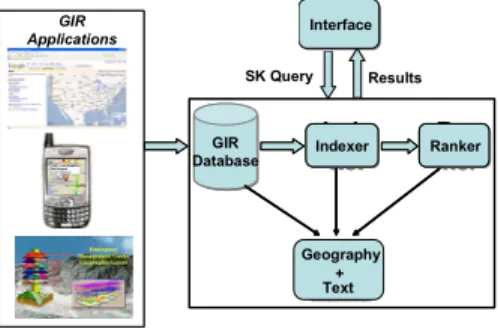
2. Framework for GIR Systems
In this section, we first describe a framework for GIR system, and how our indexing strategies can fit well within the framework in the context of different applications. The framework shown in Figure 1 consists of four major com-ponents: 1) GIR database, 2) Indexer, 3) Ranker, and 4) Interface. l b s govern ment GIS GIR Applications Inde xer Inde xer + + Ran ker Ran ker GIR Database Inde xer Indexer + Geography + Text Ran ker Ranker Interface Results SK Query
Figure 1. GIR System Framework
GIR Applications: Before describing the components of the framework, we briefly explain different GIR applica-tions that can fit within the framework. The class of applications that take as input SK queries, process them and output information sources that are relevant to the queries are called as GIR applications. Geographic (or lo-cal) search engines, location-based services (LBS) and GIS search engines are various examples of GIR applications. Geographic search engines treat Web pages as informa-tion sources and processSK queries on top of them. GIS search engines processSKqueries on top of GIS databases. LBS applications provide services based on the mobility of users. They processSKqueries on top of some specialized GIS databases mostly containing local information. Our framework can exploit both the explicit and implicit geo-graphic references found in the information sources. For example, in unstructured sources such as Web pages, geo-graphic references are implicitly found as place names, tele-phone numbers, addresses, etc., along with the other text
matter. These implicit references are extracted and con-verted to metric measurements. In structured sources such as GIS databases, the geographic references are explicitly defined as spatial attributes along with non-spatial text at-tributes. The spatial attributes along with non-spatial text attributes constitute our GIR database. For example, any GIS database available in ESRI shapefile format [6] forms an explicit GIR database.
GIR Database:The input to a GIR database can come from unstructured as well as structured data sources. There are a number of pre-processing steps involved in converting a unstructured source to a GIR database. Such tasks are geo extraction, geo matching and geo propagation. Interested readers can refer to [15] for more details. Structured sources like GIS databases also involve pre-processing steps such as coordinate conversion of spatial attributes, identification and extraction of textual attributes, etc. In our experiments, we use structured data sources and explain the details of the pre-processing steps in Section 6.
Indexer:The primary search dimensions for processingSK
queries are spatial and text attributes. Hence, the indexer in our framework builds data structures on spatial and textual attributes. In particular, we construct a hybrid index that combines both spatial and textual attributes. We can con-sider each keyword appearing in the text as having a spatial distribution. The spatial distribution of various keywords may be correlated in space. Our indexing technique ex-ploits this spatial correlation of keywords, thereby capturing their joint distribution in space. Capturing this joint distri-bution significantly improves the retrieval of answers toSK
queries. In Section 4, we describe our indexing mechanism in detail.
Ranker:The ranker combines the ranking functions of spa-tial and textual attributes. The goal of the ranking function is to assign score to objects in GIR database based on its relevance to theSK query. Given aSKqueryQ={qr, qt}
[see Definition 1], the overall ranking function is
Fsk=α1·Fr(qr, or) +α2·Ft(qt, ot),
where Fr(qr, or) is a geographic ranking function, and Ft(qt, ot)is a keyword-based ranking function.α1andα2
are suitable weights where α1 +α2 = 1. The common measure forFtis the cosine measure that computes the
rel-evance of an object to the query (based only on their cor-responding textual parts) using the tf −idf model [18].
The ranking functionFrconsiders geographic relationships
such ascontain,overlap,inside, etc., between the spatial
parts of an object and the query. Other sophisticated rank-ing mechanisms for geographic data are proposed in [1, 8] that consider geographic hierarchies.
Interface:The interface allows the user to enterSKqueries using a map and a text interface. Search engines such as Google, MSN, and Yahoo use similar interfaces. Each
SK query consists of a set of textual keywords and a ge-ographic region of interest specified as a query rectangle. We formally defineSKquery in Definition 1. The interface presents a ranked results to each query.
3. Preliminaries and Definitions
Let S be a GIR database with attributes A = {R, T}
and size N (number of objects). The domain of R is a rectangle. There are two components of a rectangle,r =
[(x1, y1),(x2, y2)]wherex1, y1, x2, y2∈ , lower-left and upper-right corners specified in Cartesian coordinates by (x1, y1)and(x2, y2), respectively. We take the minimum bounding rectangles (MBR) for line and polygon objects present inS. For point objects, the two corners of the
rect-angle are represented by the same point, that is x1 = x2 andy1 = y2. The value set ofT is the bag of keywords
{t1, t2, t3, . . .}. The domain ofTis the set of words. Each
objectoinSis represented by the tripletoid, or, ot, where oid is the object id,oris the object’s MBR, andotis a set
of textual keywords describing the object.
Definition 1: A SK query is defined as Q = {qr, qt},
whereqr ∈ is the spatial part of the query specified as
a minimum bounding rectangle (MBR), and qt ∈ T is a
set of keywords in the query. A SK query with theAND
semantics is defined as the one in which all the keywords inqtare required to be present in the retrieved records.
Definition 2: The answer set to anSK queryQis defined
as the set of objectsOq = {oiq}inS, where each object’s
MBR has a non-empty intersection with query’s MBR (i.e.,
oi
q∩qr=φ), and contains all of the query keywords inqt.
4. Indexing Mechanisms
Existing indexing work in geographic information re-trieval proposed can be broadly classified into two cate-gories: 1) separate index for spatial and text attributes and 2) hybrid index that combine spatial and text attributes. Next, we briefly discuss the ideas of the techniques.
4.1
Separate Index for Spatial and Text
Attributes
In this approach, separate index structures are built for spatial data and text data. The choice of index structure for spatial data can be grid, quadtree, or R*-tree. One com-monly used structure is R*-tree [19], and the choice of other indices are also possible. For text, [18] proposed an in-verted file index. The inin-verted file index stores for each keyword, a sorted list of object ids in which the keyword appears, its score, and frequency.
Using this approach,SKqueries can be answered in two ways. First, a set of candidate object ids that satisfy the spatial part of the query are retrieved using the spatial in-dex. The object ids are sorted and for each retrieved object id, the textual keywords of the query are looked up in its corresponding inverted list index. Finally, all the object ids that satisfy the query are collected, ranked and presented as sorted results to the user.
The second approach is to first filter object ids based on the query keywords. Inverted index list for each query key-word are looked up, and a set of object ids that are present in the intersection of the lists are passed to the next stage for spatial filtering. Finally, the scores for each object are computed by combining the ranking of textual and spatial parts. The performance of both approaches depends on the selectivity of the objects satisfying the text or spatial part of a query. If the number of objects in the spatial region of the query is small, it is better to do the spatial filtering first and vice versa. In [11], the choice for the spatial index is a grid and inverted file index for textual keywords. [3, 22] also discuss variants of this approach.
In [3], the authors propose a number of improved tech-niques to the above basic approaches. First, they suggest storing spatial data in the disk by following Hilbert curve ordering [6]. This ordering maintains the spatial closeness of objects thereby speeding up the disk access operations in retrieving the spatial data. Secondly, the objects in the inverted index list are assigned ids according to Hilbert or-dering and sorted based on these ids. A grid-based structure is built in memory to store the ids of the spatial data in each tile of the grid. When a query is issued by the user, the rel-evant tiles of the grid that overlap the spatial region of the query are retrieved. The object ids contained in the tiles are sorted and looked up against the inverted indices. Since the object ids are arranged in the disk following Hilbert order-ing, the relevant objects are retrieved using a small number of scans.
Advantages and Limitations: The main advantage of the above strategies is the ease of maintaining two separate in-dices. However, the main performance bottleneck lies in the number of candidate objects generated during the fil-tering stage. If spatial filfil-tering is done first, many objects may lie within a query’s spatial extent, but very few of them are relevant to the query keywords. This increases the disk access costs by generating a large number of candidate ob-jects. The subsequent stage of keyword filtering becomes expensive. The same is true, if keyword filtering is done first. Moreover, the above strategies assume a memory res-ident spatial index which is not reasonable for large GIR databases. In [3], this issue is discussed by proposing to re-duce the granularity of spatial index, so that it fits in main memory. However, if the grid is too coarse, it loses its prun-ing capabilities. We build a disk resident spatial index.
4.2
Hybrid Indices
Hybrid indexing techniques combine the spatial and in-verted file indices. In [11], the inin-verted list was modified as the following. The list for each keyword was augmented with the space in which the objects contained in the list appear. For instance, if w1 is the keyword, its list was augmented as: w1 ={r1(o1, o2, ...), r2(o2, ...), ....}where r1, r2, ..are bounding rectangles in space. When a query
is issued, the corresponding keyword lists are loaded, and objects are filtered using the associated spatial index. This strategy still requires scanning the entire list.
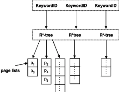
The closest work to ours is the hybrid indexing structures proposed in [22]. The first hybrid data structure shown in Figure 2 is calledInverted File-R*-tree. In this structure, first an inverted index file is built. Then, the file is modified by building a R*-tree to the set of objects’s MBR pointed to by each keyword in the file. The leaf node of R*-tree points to a page list of object ids whose entry contain the keyword and the MBR. This entry is called ageo-keyword. When a query is issued, the query keywords are filtered using the inverted index. Later, the R*-tree corresponding to each query keyword are used to filter the spatial part of the query. The intersection of object ids from the R*-trees produces the final answer set.
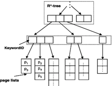
The second data structure proposed in [22] is called R*-tree-Inverted File. As shown in Figure 3, an R*-tree is first built for all the objects’ MBR irrespective of keywords. An inverted index file is created for keywords that appear in the leaf node of the tree. Each keyword in this inverted in-dex points to a page list of object ids whose entries contain both the MBR and the keyword, again referred to as geo-keyword. When a query is issued, a set of leaf nodes that intersect with the query rectangle is retrieved first. Then using the retrieved node’s inverted file index, object ids sat-isfying the query keywords are obtained.
KeywordID KeywordID KeywordID
R*-tree R*tree R*-tree
p1 p3 p2 p4 p5 .. .. .. .. . .. .. .. .. .. .. .. .. .. .. .. .. page lists
KeywordID KeywordID KeywordID
R*-tree R*tree R*-tree
p1 p3 p2 p4 p5 .. .. .. .. . .. .. .. .. .. .. .. .. .. .. .. .. page lists
Figure 2. Inverted File - R*-tree
Advantages and Limitations:The first approach proposed in [22] is highly insensitive toSKqueries with theAND se-mantics. This approach does not take advantage of the asso-ciation of keywords in space. Hence, when query contains
.. . p1 p3 p2 p4 p5 .. .. .. .. .. .. .. .. .. .. .. .. . .. .. .. .. . .. .. .. .. R*-tree KeywordID page lists .. . p1 p3 p2 p4 p5 .. .. .. .. .. .. .. .. .. .. .. .. . .. .. .. .. . .. .. .. .. R*-tree KeywordID page lists
Figure 3. R*-tree - Inverted File
keywords that are closely correlated in space, this approach suffers from paying extra disk costs accessing different R*-trees and high overhead in the subsequent merging process. In the second approach proposed in [22], the leaf nodes point to inverted index lists that are usually small. This is because any leaf node covers only a small sub-space of the entire data space and subsequently the number of distinct keywords that exist in this sub-space is expected to be small. This approach leverages the above advantage and hence the keyword filtering of objects are usually fast. However, the main disadvantage is the spatial filtering stage which gener-ates many candidate object ids.
Considering the limitations of the previous approaches, we propose a new approach that exploits the association of keywords in space. We discuss the main ideas of our tech-nique in the following section.
5. KR*-Tree: A Novel Indexing Mechanism
We propose a new indexing strategy called KR*-tree, which is an acronym forKeyword-R*-tree. We measure the effectiveness of indexing strategies in answering SKqueries with respect to the following criteria: • Pruning text and space.
• Handling queries with multiple keywords.
First, the indexing methods previously proposed use the pruning power of space and text, either separately or one followed by the other. As a consequence,SK queries are answered in a two-step filtering process, space followed by text or vice-versa. InKR*-tree, we exploit the pruning power of both space and text simultaneously, thus merging the two steps into one.
Secondly, in previous methods the keywords are main-tained separately. Hence queries are answered by the inter-section of object ids from the inverted index file or R*-trees of query keywords. InKR*-tree, we capture the joint distri-bution of keywords and hence the object ids containing the
query keywords are directly obtained without merging any lists. These characteristics greatly enhance the performance ofKR*-treein answeringSKqueries.
At the outset,KR*-treeis similar toR*-tree-Inverted File
data structure, but we make the following modifications. • All internal and leaf nodes ofKR*-treeare augmented
with a set of distinct keywords that appear in the space covered by the nodes. Thus, many keywords appear in the upper level nodes of the tree and smaller number of keywords appear in the lower level nodes of the tree. • Since the number of keywords that appear in each node
varies, we do not store the keywords in the node. We construct a special list calledKR*-tree Listthat stores the keywords appearing in the nodes. We give more details ofKR*-tree Listin the next subsection.
5.1
KR*-treeConstruction
TheKR*-treeis constructed in a way similar to how an R*-tree is constructed, but with minimal overhead in han-dling the keywords. There are two distinct steps involved in the construction of the tree.
1. First, the set of keywords corresponding to each node of the tree is determined.
2. Next, the set of keywords in each node is converted to aKR-tree List.
Step 1. In this step, we construct KR*-tree by inserting GIS data objects as shown in Algorithm 1. The algorithm is initialized with the data objectO that needs to be inserted
and the root nodeNr of the tree. For any non-leaf node
the algorithm computes the area of each of its child node by expanding it with O’s rectangle (lines 2-4). The keyword
list of N is updated with the keyword list of O (line 5).
Then, it chooses the child with minimal area and insertsO
recursively (lines 6 and 7). For a leaf node, the algorithm insertsO and updates the keyword list ofN withO’s list
(line 10-11). If the leaf node gets full,N is split (line 13),
otherwise, the algorithm returns.
The node split mechanism is explained in Algorithm 2. For any nodeN, the algorithm first creates two new nodes Na andNb (line 1). It then distributes the children ofN
toNa andNb and updates their bounding rectangles. The
keyword list ofNa andNb are updated using the keyword
list of their children nodes (line 2-3). IfNis not a root node, NaandNbare attached to the parent ofN, otherwise a new
root node is created. If the parent node gets full, then split occurs recursively (lines 4-14).
After all the data objects are inserted, each node of KR*-treecontain a set of distinct keywords that are covered under its space.
Algorithm 1 INSERT(ObjectO,NodeN)
1: ifNis NOTleaf nodethen 2: for allchildNiofNdo
3: Ai=Area(Ni.r∪O.r)
4: end for
5: N.t={N.t∪O.t}
6: SelectNiwith leastAi
7: INSERT(O, Ni) 8: Return 9: else 10: InsertO.rinN 11: N.t={N.t∪O.t} 12: ifNisfullthen 13: SPLIT(N) 14: else 15: Return 16: end if 17: end if
Algorithm 2 SPLIT(NodeN) 1: CreateNodesNaandNb
2: Distributechildren ofNtoNaandNb
3: UpdateNa.t, Na.r, Nb.t, Nb.r
4: ifNis NOTroot nodethen
5: AttachNaandNbtoN’s parent nodeNp
6: ifNpisfullthen 7: SPLIT(Np) 8: else 9: Return 10: end if 11: else
12: Createnew root nodeNr
13: AttachNaandNbtoNr
14: end if
Step 2. The number of keywords that appear in each node varies. Hence, we construct an auxiliary structure called
KR*-tree List. This list stores for each keyword, the node ids ofKR*-treein which the keyword appears, along with its parent id and children ids. TheKR*-tree Listis similar to that of an inverted file index, the only difference is that it stores the node ids instead of object ids. The number of in-ternal nodes ofKR*-treeis considerably smaller compared to the number of objects indexed. Hence,KR*-tree List oc-cupies only a small space.
5.2
Answering
SKQueries
We answer aSKquery as explained in Algorithm 3. The algorithm is initialized with queryQand the root of
KR*-tree. First, the children node idsnidsof current nodeNthat
contain all the keywords present inQare obtained (lines
1-4). Next, each child ofNthat has a non-empty intersection
withQ’s rectangle and also whose id is present in the list nids, is chosen for further traversal (lines 5-6). IfNis a leaf
node, the qualified children are added as results, otherwise, the algorithm traverses recursively (line 7-13). Finally the set of objectsOresthat satisfyQare returned in line 14.
Algorithm 3 PROCESS(QueryQ,NodeN)
1: nids=GetNodeIds(Q.t1, N) 2: for alltiinQ.tsuch thati >1do
3: nids=GetNodeIds(ti, N)∩nids
4: end for
5: for allChildNjofNdo
6: if(Nj.r∩Q.r= φAndNj∈nids)then
7: ifNjis NOTleaf nodethen
8: PROCESS(Q,Nj) 9: else 10: Ores=Ores∪Nj 11: end if 12: end if 13: end for 14: ReturnOres
5.3
Keyword Spread Problem
While we exploit the joint distribution of keywords in space, the flip side of it is what we encounter as keyword-spreadproblem. This problem occurs becauseKR*-tree in-dexes all the objects together, hence the number of nodes in which a keyword appear increases across theKR*-tree. This increase is large compared to that of the number of KR*-treenodes that index only objects containing that particular keyword. We address this problem by slightly modifying ourKR*-tree as shown in Figure 4. We traversenlevels
up theKR*-treeand maintain an inverted file index for each keyword appearing below that level. Since we are main-taining a list of separate keywords, the list becomes small and controls the keyword-spread problem acrossKR*-tree
nodes. In Figure 4, we can see the number of pages for the keywordearthquakegets compressed to single page be-low nodesn1andn2, which otherwise would have occupied more pages. We use our modifiedKR*-treein all of our ex-periments. The specific value ofndepends on the number
of objects that theKR*-treeindexes.
5.4
KR*-TreeExample
Consider a simple emergency GIS database presented in Table 1. The database has 10 objects whose spa-tial distribution and the correspondingKR*-treenodes are shown in Figure 5. Now, let us consider an SK query:
< q,{earthquake, shelter} > that asks forearthquake
shelterin the spatial regionq. In order to answer this query,
we will consider the following plans:
Space First. To answer our example query, we access the following nodes {r, n1, n2, n3, n4, n5, n6} to get the fol-lowing 5 object ids{o2, o5, o6, o8, o10}. Next, the inverted
earthquake
n2
n1
r
earthquake
Figure 4. Modified KR*-tree
OID X Y keywords 1 x1 y1 {fire, medical} 2 x2 y2 {earthquake, medical} 3 x3 y3 {fire, medical} 4 x4 y4 {facility, medical} 5 x5 y5 {earthquake, hazard} 6 x6 y6 {earthquake, medical} 7 x7 y7 {fire, facility} 8 x8 y8 {earthquake, shelter} 9 x9 y9 {fire, shelter} 10 x10 y10 {earthquake, shelter}
Table 1. Example GIS Database
indices of textual keywordsearthquakeandshelter
shown in Table 2 are looked up to further filter the object ids that contain both the keywords. Finally, the answer set for the query contains the objects{o8, o10}.
UsingR*-tree-Inverted File. For the same example query, the R*-tree nodes{r, n1, n2, n3, n4, n5, n6}are accessed to generate the candidate object set. Next, the inverted in-dex list of leaf nodes{n3, n4, n5, n6} are accessed to fil-ter objects that contain the keywords earthquake and
shelterto finally arrive at the answer set{o8, o10}.
UsingInverted File-R*-tree. For the example query, first the R*-trees of the keywordsearthquakeandshelter
are loaded to get the candidate object id lists. Then, the intersection of the two candidate object id lists gives the answer set{o8, o10}. We do not show the working of this strategy due to space constraints. However, we will show in experiments how this strategy performs.
UsingKR*-tree. We can do much better than the above strategies, if we know the joint distribution of keywords in the nodes of the KR*-tree. In general, if more than one keyword is present in a query, it can reduce the number of
q o1 o2 o5 o3 o4 o6 o7 o10 o8 o9 n3 n4 n5 n6 n1 n2 r
Figure 5. Objects Distributed in Space
keywords Object List
earthquake {o2, o5, o6, o8, o10} fire {o1, o3, o7, o9} medical {o1, o2, o3, o4, o6} shelter {o8, o10} hazard {o5} facility {o4, o7}
Table 2. Inverted File Index
Leaf Node keywords Object List
n3 fire {o1} medical {o1, o2} earthquake {o2} n4 fire {o3} medical {o3, o4} facility {o4} earthquake {o5} n5 earthquake {o6} medical {o6} fire {o7} facility {o7} hazard {o5} n6 earthquake {o8, o10} shelter {o8, o9, o10} fire {o9}
Table 3. R-*tree Inverted Index
objects in which both keywords appear. In other words, the joint frequency ofmkeywords is no greater than the joint
frequency ofm−1keywords. In our example, even though
the keywordearthquake appears manytimes in space, when it combines withshelter, the number of appear-ances of both keywords reduces.
Table 5 shows the keywords that appear in space covered by all the nodes of theKR*-tree. For the given query, we access the root first to get its childrenn1andn2. Now, for each child node, we not only check its spatial intersection with the query region, but also check for the presence of query keywords in it. In this case,n1does not contain both the keywords, butn2does, hence we only open node n2. Applying the same principle forn2’s children, we can see that onlyn6 satisfies theSK query. Hence we access only {r, n2, n6}to generate the candidate object set.
The KR*-tree List for earthquakecontains the fol-lowing node ids: {n1, n2, n3, n4, n5, n6}. The KR*-tree
Listfor all the keywords is shown in Table 4.
6. Experiments
In this section, we describe our experimental results to evaluate our techniques in comparison with the methods
keywords Node List
earthquake {n1, n2, n3, n4, n5, n6} fire {n1, n2, n3, n4, n5, n6} medical {n1, n2, n3, n4, n5} shelter {n2, n6} facility {n1, n2, n4, n5} hazard {n1, n4}
Node keywords
r {earthquake, medical, shelter, f ire, f acility, hazard} n1 {f ire, medical, earthquake, f acility, hazard} n2 {f ire, medical, earthquake, shelter, f acility} n3 {f ire, medical, earthquake}
n4 {f ire, medical, earthquake, f acility} n5 {medical, f ire, earthquake, f acility} n6 {earthquake, shelter, f ire}
Table 5. KR*-Tree - Distribution of keywords in Space
presented in Section 4.
6.1
Datasets
In our experiments, we used real datasets downloaded from www.mapdex.org that catalogs vast amounts of GIS databases. Our GIR database is mainly a repository of GIS database(s) that contains different kinds of GIS objects. We employ a number of pre-processing steps to arrive at a more structured GIR database. The downloaded GIS databases are heterogeneous in nature; that is, each of them has dif-ferent attribute fields. For each database, we identified and discarded the real-valued fields and retained the spatial and text fields. All the text fields are then combined to form one single text attribute. We performed basic pre-processing on the text such as stemming and stop-word removal. The spatial attributes from different databases are all converted to a single coordinate system. Now, our GIR database is more structured and homogeneous containing only spatial and textual data.
We used different sizes of datasets in our experiments. We categorized them as small, medium, and large datasets as shown in Table 6.
Dataset Size Spatial Objects keywords
Small 50000 75
Medium 125000 100
Large 1000000 5000
Table 6. Datasets
6.2
Queries
We generated 1000SKqueries with their spatial compo-nent consisting of different rectangle sizes and textual com-ponent consisting of 2 to 3 keywords. All of our queries consisted of a rectangle region of size sand a set of
key-words. We randomly generated rectangles of different sizes and combined them with a set of keywords that were care-fully chosen so that they resembled a real query trace.
6.3
Query Model
We used the following steps to generate query keywords: 1. Randomly select an object from the database.
2. From the distinct keywords appearing in the object’s text field, generate required set of keywords.
3. Combine each set of keywords with the rectangle gen-erated of particular size.
The above method is better than randomly combining key-words. In fact, our approach works superior for such un-usual combinations, hence we did not want to bias our ex-perimental results by adding such queries. Since our data structure indexes joint distribution of keywords, it captures the true correlation of keywords in space. For all datasets we generated rectangles of sizes 10km x 10km, 25km x 25km, 50km x 50km and 75km x 75km. These sizes repre-sent geographic area of smaller to bigger regions. We gen-erated two-set keywords and three-set keywords for each rectangle size combination. In our experiments, we report the average performance of queries in terms of random disk IOs. For small and medium dataset, we used a page size of 256KB, and for the large dataset we used a page size of 512KB in constructing theKR*-tree.
6.4
Performance Comparison
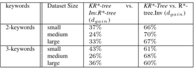
In Table 7, we show in a nut shell the performance of various indexing structures. Ifd1 andd2 are the disk IOs incurred by index i1 and indexi2 respectively, we define performance gain through disk IO reduction ofi1overi2as
dgain= (d2−d1)∗100
d2 . Positive value indicates better
perfor-mance ofi1overi2. In this table, we report thedgainof our
KR*-treein comparison with others.
keywords Dataset Size KR*-tree vs.
Inv.R*-tree (dgain) KR*-Treevs. R*-tree.Inv (dgain) 2-keywords small 37% 66% medium 24% 70% large 33% 67% 3-keywords small 43% 61% medium 26% 68% large 36% 60%
Table 7. Average Disk I/Os
For 2-keyword queries, our indexing strategy achieves a reduction in disk IOs ranging from 24% to 37% and from 60%to 70%compared with Inverted Index-R*-tree
and R*-tree-Inverted Index, respectively. For 3-keyword queries, the reduction is slightly more compared with In-verted Index-R*-tree, ranging from26%to43%. The im-provement occurs bacause our strategy is sensitive to the number of keywords. As the number of keywords increases,
KR*-tree performs better. On the other hand, KR*-tree’s
performance gain overR*-tree-Inverted Indexis slightly re-duced compared to the 2-keyword queries. This is because, the disk IOs inR*-tree-Inverted Indexis dominated by the spatial filtering step that is insenstive to the number of
key-words. On the other hand, the didk IOs for KR*-tree in-creased overall.
In Figures 6-11, we show detailed plots of disk IOs in-curred by various strategies for different sizes of datasets and for different number of query keywords. In all the plots, we can see thatKR*-treesignificantly outperforms R*-tree-Inverted Indexand moderately outperformsInverted Index-R*-tree.
7. Related Work
There has been lot of interest in building geographic in-formation retrieval systems. The first work of this kind started in the context of digital library (DL) projects such as GIPSY at UC Berkeley and Alexandria Digital Library Project at UC Santa Barbara [12]. In these projects, the main objective is to address the extraction of geographic references found in the text by using ontologies, gazetteers, thesaurus, etc., and convert them to coordinates for retriev-ing DL contents usretriev-ing geography.
In the context of geographic search engines, there are numerous academic projects. Most of them can be broadly classified under 1) work that focused on extraction of geo-graphic references from documents and/or 2) efficient query processing. We will briefly describe a few of these. In GeoSearch System [10], the geographic scope of Web pages are extracted by analyzing the geographic references in text as well as the geographic location where the Web sites are registered. In [15], the focus is on improving the extrac-tion techniques. In particular, after the relevant geographic references are extracted, ambiguities such as multiple place name references and alternate place names are resolved us-ing techniques such as geo-matchus-ing and geo-propagation. Other relevant studies that addressed geographic search on the Web are [11, 5].
In the context of query processing for GIR, indexing techniques for processing text and geographic data are the main focus. In [11], a simple inverted index structure for text and grid file for geographic data are used. They pro-pose a hybrid index structure in which each keyword is combined with different partitions of space. In effect what they are proposing is similar to [22]. The other technique proposed in their work concatenates keyword with region identifier. For example, keywordearthquake is com-bined with spatial region ”R1” and represented as spatio-textual key ”earthquakeR1”. All the documents that are in ”R1” and contains the textearthquakeare attached as list to the key ”earthquakeR1”. There are drawbacks of this approach. First, for large set of objects, this approach will generate a large number of false positives. For query con-taining multiple keywords and spatial region, a number of such keys have to be looked up and filtered.
In a recent work [3], the authors propose to maintain
individual indices for spatial and textual data. They pro-pose various approaches to retrieve data from each index before the final merging of results. The spatial objects in-dexed in their applications are complex footprints that are extended regions in space. They approximate them by us-ing MBRs and use memory-resident spatial index. Their approach does not scale well with increasing size of the dataset. To alleviate the problem, they propose to compress the MBRs, but the attempt generates large candidate set that needs to be fetched from the disk, with a high rate of false positives. This will become a major performance bottle-neck for large scale GIR applications. In our work, we use disk-resident spatial index for GIR applications. Our data structure performs significantly better than their approach with respect to two aspects: 1) first it reduces the number of disk accesses in identifying the candidate objects and as a consequence 2) it reduces the overhead in merging the can-didate objects.
In another very related work [22], the authors proposed a hybrid index by combining the spatial and inverted list structures. Their approaches either use multiple R*-trees to answer queries or generates more candidates for further filtering. The main limitations of their approach are already discussed in detail in Section 4.
8. Conclusions and Future Work
In this paper we proposed a novel indexing data struc-ture called KR*-tree for processing SK queries with the
ANDsemantics by capturing the joint distribution of key-words appearing in space. Given the common nature of such queries, we discussed the performance bottlenecks of current indexing mechanisms in processing them. Then we showed through an example GIS database and later through detailed experiments that our approach significantly reduces such bottlenecks by directly reducing the disk IOs incurred during spatial filtering of objects.
We plan to address some open problems as future work. First, we would like to explore how to adapt our indexing when there are many GIS databases. Here the main prob-lem is that of database discovery not the individual records within the databases. In such a setting, the query seman-tics(AND/OR)changes and the user may require onlytop-k
databases relevant to the query. The ranking is computed for the entire database using the individual records within the database. This requires storing the aggregated pre-computed scores of objects within ourKR*-treeand coming up with pruning strategies to generatetop-kresults.
9 Acknowledgements
This work is supported by the National Science Founda-tion under Award Number 0331707.
0 500 1000 1500 2000 2500 3000 3500 4000 10x10 25x25 50x50 75x75 I/O Query Size KR*-tree Inv.Index:R*-tree R*-tree:Inv.Index Figure 6. Small, 2-keywords. 0 1000 2000 3000 4000 5000 6000 10x10 25x25 50x50 75x75 I/O Query Size KR*-tree Inv.Index:R*-tree R*-tree:Inv.Index Figure 7. Medium, 2-keywords. 0 200 400 600 800 1000 1200 1400 1600 10x10 25x25 50x50 75x75 I/O Query Size KR*-tree Inv.Index:R*-tree R*-tree:Inv.Index Figure 8. Large, 2-keywords. 0 500 1000 1500 2000 2500 3000 3500 4000 4500 10x10 25x25 50x50 75x75 I/O Query Size KR*-tree Inv.Index:R*-tree R*-tree:Inv.Index Figure 9. Small, 3-keywords. 0 1000 2000 3000 4000 5000 6000 10x10 25x25 50x50 75x75 I/O Query Size KR*-tree Inv.Index:R*-tree R*-tree:Inv.Index Figure 10. Medium, 3-keywords. 0 200 400 600 800 1000 1200 1400 1600 1800 10x10 25x25 50x50 75x75 I/O Query Size KR*-tree Inv.Index:R*-tree R*-tree:Inv.Index Figure 11. Large, 3-keywords.
References
[1] M.K. Beard and V. Sharma. Multidimensional Ranking in Digital Spatial Libraries. InSpecial Issue of Metadata. Jour-nal of Digital Libraries, Vol.1, No. 1, 1997.
[2] O. Buyukkoten, J. Cho, H. Garcia-Molina, L. Gravano, and N. Shivakumar. Exploiting Geographical Information of Web Pages. InWebDB, pages 91-96, 1999.
[3] Y. Chen, T. Suel, and A. Markowetz. Efficeint Query Process-ing in Geographic Web Search Engines. InProc. of ACM SIG-MOD, pages 277-288, June 2006.
[4] J.Ding, L. Gravano, and N. Shivakumar. Computing Geo-graphical Scopes of Web Resources. InProc. of VLDB, pages 545-556, September 2000.
[5] M. Egenhofer. Toward the Semantic Geospatial Web. InProc. of ACM GIS, pages 1-4, November 2002.
[6] ESRI Shapefile Technical Description. An ESRI White Paper - July 1998. http://www.esri.com/library/whitepapers/pdfs/shapefile.pdf [7] Geospatial One-Stop E-Government Initiative.
www.geodata.gov.
[8] S. Gobel and P. Klein. Ranking Mechanisms in Meta-Data In-formation Systems for Geo-Spatial Data. InProc. of EOGEO, 2002.
[9] Google Local Search. http://local.google.com.
[10] L. Gravano. Geoserach: A Geographically-Aware Search Engine, 2003. http://geosearch.cs.columbia.edu
[11] C.B. Jones, A.I. Abdelmoty, D. Finch, G. Fu, and S. Vaid. The Spirit Spatial Search Engine.: Architecture, Ontologies and Spatial Indexing. InProc. of GIScience, pages 125-139, October 2004.
[12] R.R. Larson. Geographic Information Retrieval and Spatial Browsing. InGIS and Libraries: Patrons, Maps and Spatial Information, pages 81-125, 1996.
[13] R.R. Larson. Geographic Information Retrieval (GIR): Searching Where and What. InIn Proc. of the 27th Intl. ACM SIGIR Conference on Research and Development in Informa-tion Retrieval (SIGIR), page 600, July 2004.
[14] Mapdex Geographic Data Search. www.mapdex.org. [15] A. Markowetz, Y. Chen, T. Suel, X. Long, and B. Seeger.
Design and Implementation of a Geographic Search Engine. In Proc. of WebDB, June 2005.
[16] MSN Local Search. http://local.live.com.
[17] C. Ohm, G. Klump, and H. Kriegel. Xz-ordering: A Space-Filling Curve for Objects with Spatial Extension. InProc. of the 6th Intl. Symp. on Advances in Spatial Databases, pages 75-90, July 1999.
[18] A. Singhal. Modern Information Retrieval: A Brief Overview. InIEEE Data Engineering Bulletin, Special Issue on Text and Databases, Vol. 24, No. 4, December 2001. [19] Timos K. Sellis. Review - The R*-Tree: An Efficient and
Robust Access Method for Points and Rectangles InACM SIG-MOD Digital Review 2, 2000.
[20] S. Vaid, C.B. Jones, H. Joho, and M. Sanderson. Spatio-Textual Indexing for Geographical Search on the Web. In Proc. of SSTD, 2005.
[21] Yahoo Local Search. http://local.yahoo.com.
[22] Y. Zhou, X. Xie, C. Wang, Y. Gong, and W. Ma. Hybrid Index Structures for Location-Based Web Search. InProc. of CIKM, pages 155-162, November 2005.