I
llinois
T
ransportation
A
rchaeological
R
esearch
P
RogRAm
University of Illinois @ Urbana–Champaign TARP
I
ITARP
2005
Annual Report of
Investigations Undertaken for
the Illinois Department of Transportation by
the Illinois Transportation Archaeological Research Program
2005 Annual Report
Compiled by
Wendy Smith French
Thomas E. Emerson, Ph.D.
Principle Investigator and Program Director
Illinois Transportation Archaeological Research Program
University of Illinois at Urbana–Champaign
Investigation Conducted Under the Auspices of
The State of Illinois
Department of Transportation
John Walthall, Ph.D.
Chief Archaeologist
Cover design by Linda Alexander On theCover
Upper left Excavations at Janey B. Goode (11S1232), a complex multi-component habitation site in the Am-
erican Bottom in St. Clair County.
Lower left Excavation of a cellar at Dutcher II (11LE73), a historic mid-nineteenth century site located dur-
ing survey for a bridge replacement over the Green River in Lee County.
Center Excavations at the Marlin Miller #2 site (11HA318), an early Late Woodland Weaver habitation
located partially within the proposed IL 336 ROW in Hancock County. On the Back
ITARP archaeologist, Jamey Zehr, excavates discarded large animal bones at Dutcher III, a mid-1800s occupa-tion in Lee County.
The Illinois Transportation Archaeological Research Program (ITARP) is the product of a long-term coopera-tive effort between the University of Illinois and the Illinois Department of Transportation (IDOT), beginning in 1957, to preserve the state’s important archaeological resources. In 1959, under the direction of Charles J. Bareis, the program evolved as the Illinois Archaeological Survey and continued in 1980 when the IDOT statewide survey program was transferred to the Resource Investigation Program, finally reaching its present form with the creation of ITARP in 1994. The establishment of this intergovernmental program was the result of IDOT’s interest in developing a centralized administration to facilitate its cultural resources protection efforts.
One of ITARP’s primary goals is the dissemination of information to both professional and public audi-ences. This Annual Report is designed specifically to provide an overview of the program’s yearly activities for the IDOT and University engineers and administrators, the archaeological community, and the general public. The contents of this report reflect the view of the contributors who are responsible for the facts and accuracy of the data presented herein. The contents do not necessarily reflect the official views or policies of the Illinois Department of Transportation.
The production of the Annual Report is the responsibility of the Statewide Archaeological Survey Division, under the direction of Mr. Dale McElrath. This year’s report is compiled and coordinated by Ms. Wendy Smith French and produced through the efforts of the ITARP Production Office under the direction of Publications Manager Mike Lewis and Production Coordinator Corinne Carlson, with the assistance of Graphic Designer Linda Alexander.
Thank you to Dr. John Walthall, Chief Archaeologist at IDOT, and the Illinois Department of Transportation for their support of the Illinois Transportation Archaeological Research Program’s investigations. Dr. Thomas Emerson, ITARP director, and Dale McElrath, ITARP Statewide Coordinator, provided guidance in the prepa-ration of the 2005 Annual Report. The report was prepared with the assistance of many at the various ITARP divisions. Andrew Fortier, Doug Jackson, and Jamey Zehr (C-U), David Nolan and Amy Graham (WISD), Shane Vanderford and Jennifer Pearce (NISD), Brad Koldehoff and Charles Witty (ABSD), and Joe Galloy (Wood River Lab) and their staff provided updates of continuing surveys and site investigations,as well as the excellent photos included the report. Laura Kozuch summarized curation’s 2005 activities. Mike Farkas produced the maps that illustrate ITARP’s efforts around the state. The ITARP production staff, under the direction of Mike Lewis, has given support and production expertise in the preparation of the annual report. Corinne Carlson formatted the text and figures, and Linda Alexander created the cover design (and delicious brownies). Together they gave the report its professional look. Thank you to all who contributed.
Information on obtaining additional copies of this report, as well as other ITARP volumes, is available at:
Table of Contents
Program Structure ...4
Project Review ...4
Sites Investigated and/or Analyzed in 2005 ...6
District 1 ...7 District 2 ...7 District 3 ...10 District 4 ...10 District 6 ...13 District 8 ...18 District 9 ...23
Archaeological Testing Short Reports ...23
District 2 ...23 District 3 ...24 District 4 ...25 District 6 ...26 District 8 ...28 District 9 ...32
Professional and Public Outreach...33
Figure 1. Excavations at the Dutcher II Site, Lee County ...4
Figure 2. Excavation of Pottery and Lithic Artifacts at the Janey B. Goode Site in St. Clair County ...5
Figure 3. 2005 Project Overview by IDOT District ...6
Figure 4. Chert Knives from the Fourteenth-Century Hoxie Farm Site in Cook County ...7
Figure 5. Professor Emeritus Robert Hall Examines Portions of Ceramic Vessels from Hoxie Farm ...8
Figure 6. Map of the Hoxie Farm Fortified Village ...9
Figure 7. Cellar Walls Excavated at the Dutcher II Site, Lee County ...10
Figure 8. Excavation of Discarded Large Animal Bones at Dutcher III, Lee County ...11
Figure 9. Oneota Vessel from a Storage Pit at the Shorten Site, Henderson County ...13
Figure 10. Excavations at the Chenoweth Site, McDonough County...14
Figure 11. Decorated Ceramics from the Horseshoe Pond Site, Brown County ...15
Figure 12. Excavations at the Extensive Early Late Woodland Marlin Miller #2 Site in Hancock County ...16
Figure 13. Machine Scraping Revealed Archaic Pits and Posts at the Thomas East Site, Hancock County ....17
Figure 14. A Historic Structure is Excavated at the Scarritt Farm Site in Madison County...19
Figure 15. Decorated Ceramics from the Historic Scarritt Farm Site, Madison County...20
Figure 16. Machine Scraped Portion of the Late Woodland Wilderman Site, St. Clair County ...21
Figure 17. Bone Kingfisher Pin Recovered from the Janey B. Goode Site in St. Clair County...22
Figure 18. Woodworking Tool Cache Located at the Janey B. Goode Site in St. Clair County ...22
Figure 19. Earth Oven Excavated at the Halloween Site, Jackson County ...24
Figure 20. 1816 Half Reale Coin Located in Vermilion County ...34
Figure 21. Chert Lizard Identified for a Pike County Farmer by ITARP Archaeologists ...34
Figure 22. ITARP Archaeologist, Doug Jackson, Identifies Artifacts ...35
Figure 23. ITARP Physical Anthropologist, Eve Hargrave Presents Illinois Archaeology to a Gradeschool Classroom ...35
Figure 24. ITARP Archaeologist and GIS Coordinator, Mike Farkas, Surveys and Maps the Aiken Mound Group in Jo Daviess County ...36
Program Structure
The Illinois Transportation Archaeological Research Program (ITARP), under the direction of Dr. Thomas Emerson, is charged with conducting archaeological resource review and compliance work for the Illinois Department of Transportation (IDOT) highway and highway-related projects throughout the state. Projects are investigated under the auspices of the Statewide Survey Division, coordinated by Dale McElrath, and the Special Projects Division, coordi-nated by Andrew Fortier; both divisions are based at the University of Illinois at Urbana-Champaign.
The Statewide Survey Division is responsible for conducting the majority of Phase I surveys and Phase II and III archaeological site investigations for IDOT projects in Illinois. Statewide Survey branch offices are located in Jacksonville (Western Illinois survey Division/WISD), Belleville (American Bottom Survey Division/ABSD), and Rockford (Northern Illinois Survey Division/NISD), with satellite laboratories in Macomb and Springfield. WISD conducts project sur-veys in Districts 4 and 6, Greene and Jersey Counties in District 8, and, when needed, Rock Island and Henry Counties in District 2. ABSD is responsible for project surveys in Districts 8 and 9 and portions of District 7. NISD provides project survey in Districts 1 and 2. A district archaeologist and crew from the Champaign office perform surveys in District 3, 5, and portions of
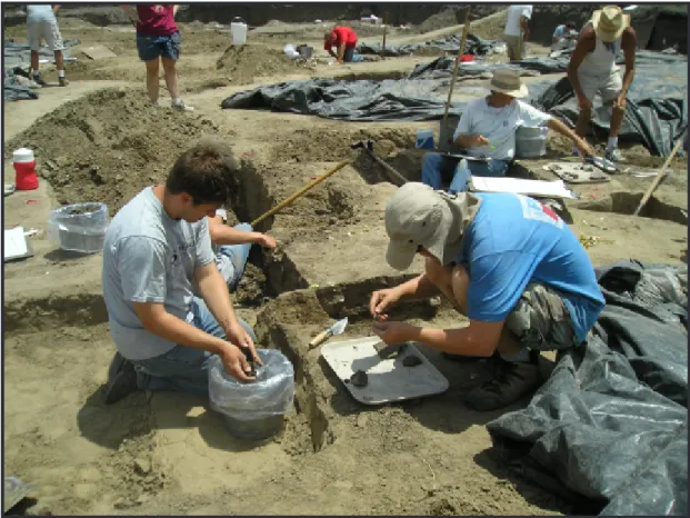
Figure 1. Excavations at the Dutcher II site, part of the Rockyford Road ghost town in Lee County. Mid-nineteenth century sealed beer bottles were recovered from this cellar.
District 7. Statewide Survey archaeologists test and excavate sites recommended for further investigation in their respective districts (Figure 1).
Large-scale and/or multi-site survey and exca-vation projects are the purview of the Special Projects Division. The Wood River Lab, a branch of Special Projects, is the base of operation for FAP 310 and New Mississippi River Crossing (NMRC) investigations in southwestern Illinois, including the ongoing excava-tions at the Janey B. Goode site (11S1232) in St. Clair County (Figure 2). The Special Projects Division has conducted the excavation and continuing analysis of the Hoxie Farm site (11CK4) in conjunction with the FAI-80/Kingery Expressway project near Chicago.
Archaeobotanists, physical anthropologists, a historical archaeologist, and cartography/GIS, cura-tion and produccura-tion departments, all based in the Champaign office, provide program support. A his-toric researcher in the Springfield Research Lab and a historian who works on a contract basis are additional resource staff. See Appendix 5 for a discussion of 2005 curation and production activities.
Project Review
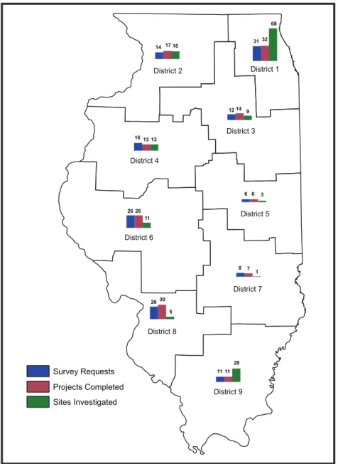
During 2005, ITARP received 150 project survey requests from IDOT that initiated Phase I archaeologi-cal reconnaissance in a total of 62 counties in all nine
ITARP 2005 5
IDOT highway districts. More than 80 percent of these surveys were completed by year’s end (Figure 3).
About 50 percent of survey requests received in 2005 were for highway and highway/bridge projects. Borrow and bridge projects each comprised approxi-mately 20 percent of survey requests received. The remaining projects fell into a variety of type categories, from airports to wetland mitigation projects. Federal/ state funding accounted for more than one-third of the 2005 project funding sources. A total of 46 projects received some MFT funding. Projects received in 2005 are outlined in Table 1.
A total of 156 IDOT projects were completed or resolved in 2005; of these, 125 were received in 2005 and 31 were pending at the end of 2004. Phase I archaeological survey was completed at 132 project locations that did not require further investigations; 32 of these projects had sites that were not recommended for further work. (Initial survey was also accomplished for eight projects received in 2005 with sites that were recommended for testing.) Nine of 11 projects with sites recommended for Phase II or III investigations were completed, and two were revised to avoid impacts during construction. Another project was surveyed
Figure 2. Excavation of pottery and lithic artifacts at the Janey B. Goode Site in St. Clair County.
and an alternate project area was chosen to avoid cul-tural resources. Nine project requests were cancelled, and two projects were superseded by revised projects. Phase I survey was also completed for an IDOT land sale. Completed projects are summarized by district, county, and resolution status in Table 2.
At the end of 2005, 144 projects require Phase I survey, further site investigations, or a final report (Table 3). Twenty-eight projects require completion of Phase I survey and/or Archaeological Testing Short Reports (ASSR). Phase II or III site investigations are either in progress or planned for 52 projects (Tables 3 and 4). Written reports are pending for 51 completed projects (Tables 3 and 5). Twelve projects are currently on hold (Table 3).
A total of 154 archaeological sites were in-vestigated for 37 projects in 2005 (Figure 3). Fifty-one sites were previously identified (revisits) and 102 sites were newly recorded. More than half the sites (N=79) did not require additional work be-yond the initial evaluation and another 20 percent (N=30) were located outside the area of project impact. Phase II or III investigations were recommended for 43 sites recorded or revisited during 2005. A further
revisit for one Jo Daviess County site and exclusion of a site area from an IDOT land sale parcel in Adams County were also recommended. Site data are sum-marized in Table 6.
Sites Investigated and/or
Analyzed in 2005
A number of sites investigated in 2005 have ongoing excavations or require a final report (Table 3). Survey for the Prairie Parkway project, a multi-county
connector between I-80 and I-88 was initiated in 2005 and has located 57 sites and a large number of find spots to date; recommendations for further work are pending. A number of sites have been identified and tested/excavated in conjunction with the FAP 315/ IL 336 survey. In total, Statewide Survey personnel examined more than 500 cultural features in 2005, in-cluding approximately 250 historic and 250 prehistoric features at 14 locations. Special Projects crews exposed and/or excavated 121 historic features at the Scarritt Farm site (FAP 310) and 2,072 prehistoric features at the Janey B. Goode site (NMRC). The analysis of materials recovered from the multi-year excavations
Figure 3. 2005 Project Overview by IDOT District.
District 2 District 1 District 3 District 4 District 5 District 6 District 7 District 8 District 9 26 11 8 6 26 16 12 31 14 30 11 7 6 26 13 14 32 17 28 5 1 3 11 13 9 68 16 Survey Requests Projects Completed Sites Investigated
ITARP 2005
at the Hoxie Farm site (11CK4) continues and draft reports have been prepared for the Fortified Village portion of the site. Following are brief summaries of work at these sites/projects and associated prehistoric and historic materials.
District 1
Hoxie Farm Site, FAI 80/I-80, Kingery Expressway, Cook County
The Hoxie Farm site (11CK4) is primarily an Upper Mississippian site located in southern Cook County, Illinois that was subjected to extensive inves-tigations by ITARP personnel. Since the completion of field investigations in the spring of 2003, various researchers based at the ITARP Champaign office, as well as ancillary researchers based elsewhere, have been analyzing the massive collections recovered from this site (Figures 4 and 5). The excavated site remains consist of two spatially distinct “components.” One of these is a large, fourteenth century Fisher phase forti-fied settlement that we refer to as the Fortiforti-fied Village (Figure 6) and the other consists of a series of intensive Fisher or Huber phase occupations from a portion of the site that we refer to as the Main Occupation Area. Research efforts in 2005 continued to focus on the Fortified Village. Initial drafts have been completed or
nearly completed for most of the projected chapters on this segment of the site. Archaeobotanical and faunal remains sections have yet to be completed and the final summary/discussion chapter also needs to be completed. While work has centered on the write-up of the Fortified Village, analysis has continued on as-semblages from the Main Occupation Area.
District 2
Dutcher Sites I–III, Rockyford Road Realignment and Bridge Replacement over the Green River, Lee County The Dutcher I (11LE72), II (11LE73), and III (11LE74) sites were identified during the Phase I survey of the proposed realignment of FAS 1184/Rockyford Road, bridge replacement over the Green River with intersection improvements at River View and Newman Roads (ITARP Project Log # 04080). A summary of Phase I and II investigations at these sites has been previously reported in the Data Recovery Plan and Research Design for 11LE72, 11LE73, and 11LE74 (Dutcher I, II, and III) Section 28, T20N-R10W, Lee County, Illinois (ITARP Project Log #04080) (Vanderford and Mazrim 2005) submitted to IDOT on May 13, 2005. Phase III investiga-tions were performed May 16–July 8, 2005.
Site 11LE72 encompasses an area of 1.3 acres
(5,124.1 m2) of which, 33 percent or .42 acre (1,715.9 m2)
0 5 cm
Figure 5. Professor Emeritus Robert Hall, University of Illinois Chicago, examines portions of ceramic vessels from Hoxie Farm, a late prehistoric site in the Chicago area.
ITARP 2005
0 10 20 30 40 50
Meters 11CK4—Hoxie Farm
Figure 6. Map of Hoxie Farm Fortified Village. Remnants of four fortification ditches, which enclosed an estimated 12 acre settlement, are visible on the left (in blue).
falls within the proposed FAS 1184 ROW. The entire area within the proposed ROW was mechanically stripped resulting in the identification of 52 cultural features. The features consisted of four cellars (likely of residen-tial function), one cistern, one root cellar, three privies, two possibly associated wall trenches, three fence lines composed of round and square posts, 18 pits of un-known function, and 20 scattered features identified as posts during field excavation. Material recovered from these features is wholly consistent with an 1840s to late 1860s/early 1870s occupation. Material post-dating the Civil War is largely absent; however, one basal sherd with maker’s mark “Pankhurst/England” establishes the initial fill episode of cellar F40 as post-1890. The southern portion of the site was thought to contain a blacksmith-ing component, based upon the metal detectblacksmith-ing results, and the large amounts of clinker/slag recovered during the initial Phase II investigation. The complexity of the feature composition in this area (15 of 52 features), and the nature of the fill will be examined during analysis to shed light on the function of the features and the potential activities associated with this portion of the site.
All of site 11LE73 (Figure 7) fell within the
proj-ect area. The entire 455 m2 site area was mechanically
stripped of plow-zone, resulting in the identification of
29 features. Twenty-one of these had been previously excavated during Phase II investigation in the fall of 2004; the remainder of the features were excavated during Phase III investigations. The material located in the large cellar, Feature 4, is consistent with an 1840s to 1870s occupation. A large number of Bristol-marked beer bottles with intact stoppers and one wine bottle with an intact stopper were located. The remaining features excavated during Phase III mitigation included one privy, two prehistoric pits, and four posts.
Site 11LE74 is about .11 acre (444 m2) in area,
96 percent of which falls within the project limits. One hundred percent of the area within the proposed ROW was mechanically stripped of plow-zone overburden and all features exposed were excavated. Phase I metal detecting had recovered domestic, architectural, and wagon/tack-related artifacts within the site boundar-ies of 11LE74. Twenty-three features were identified and excavated, including one animal processing pit, one pig burial, three fence lines (two of which ran roughly parallel to existing Rockyford Road), two miscellaneous historic pits, four multi-zone post/pit features that were approximately 39 cm to 65 cm in depth, and 13 features identified as circular or square posts during excavation (Figure 8). Material recovered
from these features is also consistent with an 1840s to late 1860s/early 1870s occupation and is similar to material recovered at 11LE72 and 11LE73. Further analysis may reveal spatial patterning and special site function relating to specific areas of the site.
District 3
Prairie Parkway, I-80 to I-88
Survey for the Prairie Parkway project (ITARP Project Log #05051) commenced in June 2005. By the end of the field season, a total of 84 find spots and 57 sites had been collected. This number breaks down to 69 prehistoric find spots, 13 historic find spots, 2 prehistoric/historic find spots, 28 prehistoric sites, 22 historic sites, and 7 prehistoric/historic sites. A total of 15 diagnostic points have been pulled during the lithic inventory for a more detailed analysis. Historic artifacts have been given to Mark Branstner to inventory and identify diagnostics. Once his analysis is complete, many of the collected assemblages may be discarded, which could reduce the total number of historic find spots and sites. At this time, the lithic material has been inventoried and site forms for the prehistoric sites have been submitted for site numbers. To date, 1,947
acres (11.2 percent) of the 17,307 acre project have been surveyed. Survey will resume in March 2006.
District 4
Postin Site, US 24/IL 100,
Spoon River Bridge Crossing, Fulton County Narrow portions of this multicomponent pre-historic site (11F2987) on either side of US 24 were subjected to Phase II testing in May and June as part of the FAP 317, US 24/IL 100 Spoon River Bridge Crossing project (ITARP Project Log #00197). The proposed ROW will impact less than a third of the extant scatter limits
(ca. 8,700 m2), which occupy a narrow upland interfluve
located immediately east of the Spoon River bluff. The ITARP investigations included comprehensive surface collection of the proposed ROW, gridded auger tests, and the machine aided removal of plow-zone from an
approximately 1,011 m2 area. These investigations
docu-mented that the site is heavily deflated and minimally reflects occupation during the Middle Archaic and Late Woodland periods. Only six shallow prehistoric feature remnants and a single isolated line of possible post molds were discovered and excavated within the project confines. One of these features produced some
ITARP 2005 11
poorly preserved human remains that were mapped, removed, and treated in accordance with all procedures and guidelines outlined in the Illinois Human Skeletal Remains Protection Act (HSRPA, 20 ILCS 3440, 17
IAC 4170). Given the poor state of preservation, lack of phase specific diagnostics in secure context, mixed nature of the plow disturbed deposits, and the fact that all seven features were excavated as a result of
ing, no further work was recommended for the ROW portion of the site. An ATSR was drafted in 2005 and will be submitted when the report on the recovered human remains is completed.
Kurrle Site, TR 195A Bridge Replacement over Dugout Creek, Henderson County
Site 11HE550 was discovered and tested by ITARP personnel as part of a local roads borrow study relating to the TR 195A bridge replacement project (ITARP Project Log #05094). The scatter minimally
covers a 2,767 m2 area of a sandy terrace remnant
located in the Mississippi River floodplain near Lomax in Henderson County, Illinois. Evidence for later Late Woodland and Oneota components was recovered during survey, which consisted of both pe-destrian reconnaissance and gridded auger tests. Five 1 m x 2 m hand units were subsequently excavated adjacent to the current roadway in the proposed bor-row area west of TR195A. These tests documented that this part of the site had probably never been plowed, so these duned, sandy sediments contain ephemeral yet weakly stratified cultural deposits. However, only a single, nondiagnostic cultural feature was identified and removed at this time. A data recovery plan for 11HE550 and 11HE551 (see below) was subsequently prepared and submitted to the IDOT/IHPA prior to undertaking incremental machine scraping in the proposed borrow area during September 2005. These
excavations (ca. 818 m2) resulted in the mapping and
removal of six other subsurface anomalies (several of these appear to have been natural), as well as the re-covery of isolated diagnostics suggestive of additional Early Archaic, terminal Archaic, and Early Woodland Black Sand components. This work also demonstrated that the proposed borrow removal area crosscuts the sloping western margin of the site/terrace, where there were fewer intact deposits and more substantial historic impacts. Based upon this, cultural resources clearance was recommended for the proposed bridge improvement project and attendant borrow removal. An ATSR for the Kurrle site is pending.
Shorten Site, TR 195A Bridge Replacement over Dugout Creek, Henderson County
Site 11HE551 was discovered and tested by ITARP personnel as part of the above-mentioned TR 195A bridge replacement project (ITARP Project Log #05094). The scatter is located on the same sandy terrace remnant as 11HE550 but was separated from the above site due to the presence of an intervening channelized stream course (Dugout Creek). Prior to our initial
sur-vey, the site area (minimally 6,642 m2) had been used by
the landowner on several different occasions as a source of fill to repair breaches in the adjacent man-made creek levee. These impacts removed several feet of sediment from the project-specific parts of the site and exposed Early Archaic Kirk cluster diagnostics and abundant flaking debris at the surface near the western margin of the scatter. The area where Henderson County plans to remove borrow to raise the adjacent bridge approaches was subjected to machine-aided topsoil removal in August 2005. Thirty subsurface anomalies were subsequently identified and excavated in the
1,066 m2 bladed area. Although many of these features
failed to produce diagnostic remains, a number of the pits can be attributed with confidence to Develop-mental Oneota and later Late Woodland components (Figure 9). The Oneota features were generally large, well-defined cylindrical-shaped storage pits, whereas the later Late Woodland features typically were smaller or more oval to elongated in shape. Since the ITARP investigations removed the affected cultural resources, project clearance was recommended contingent upon avoidance of portions of the site currently located outside the proposed impact area. An ATSR for the Shorten site is pending.
Chenoweth Site, IL 336, Carthage to Macomb Four-lane Highway, McDonough County
Testing and mitigation of this large, multicom-ponent prehistoric and historic site (11MD771) was undertaken as part of the FAP 315/IL 336, Carthage to Macomb four-lane highway project (ITARP Project Log #03136). In 2003, ITARP personnel previously tested the northern portion of this site, which is bisected by US 136, and a small portion of the southern site area for a related frontage road construction project (ITARP Log #02201). The remainder of the southern scatter area (ca.10,000
m2) is currently situated within the proposed IL 336/
US 136 interchange and was subjected to data recovery investigations during the spring and summer of 2005 (Figure 10). These investigations included a gridded total surface collection, remote sensing surveys (mag-netometer and metal detector), hand unit excavation, and gridded mechanical plow-zone removal. A total of 145 features were defined and excavated within the
hand-dug (24 m2 area) and machine scraped (4,000 m2)
test units. The majority of the features relate to two separate historic components (Pioneer and Frontier/ Early Industrial), although a substantial Middle Archaic Helton-age with preserved pit features and subsurface lithic concentrations component is also present. An ad-ditional unidentified Woodland-age component also
ITARP 2005 13
appears to be represented by at least a couple of pits with tiny sherd fragments. These investigations have mitigated the negative impact to the site, so no further work is recommended as part of the proposed project. Analysis of the site remains is currently underway and a final report is pending.
District 6
Fire Swamp and Horseshoe Pond Sites, Wetland Mitigation Bank,
Wessel Property, Brown County
The Horseshoe Pond site (11BR442) is located in the central Illinois River valley on a low, narrow floodplain ridge situated near the mouth of the LaMoine River. Testing was undertaken in the spring of 2005 to
evaluate the impact of proposed drainage ditch dredg-ing activities to the site; this work is part of a larger wetland restoration project currently being undertaken by IDOT in Brown County (ITARP Project Log #01056). The site surface was initially subjected to a gridded total collection and metal detector survey, which yielded evidence for a substantive mid-nineteenth century historic component with two separate but apparently contemporary material concentrations (households)
that together extended across a 4,080 m2 area of the
ridge (Figure 11). Subsequent hand and
machine-aided excavations (600 m2 area) produced evidence
for intact pit features in each household area with a diverse array of associated ceramics (1840s–1860s) and well preserved ecofacts. While there was no surficial evidence for prehistoric occupation of this ridge, some limited deeper machine trenching and hand excavations documented that Early Woodland Black Sand and Late
Figure 9. Oneota vessel from a storage pit at the Shorten site located during survey for a bridge replacement over Dugout Creek in Henderson County.
Archaic occupation zones are buried approximately .50 m and .90 m below the modern surface, respectively. A similar sequence of stratified prehistoric remains was encountered during more limited geoarchaeological
trenching (13 m2) at the Fire Swamp site (11BR441),
located approximately .2 km west on this same land-form. Based upon the stratified nature of the two sites and their potential significance, IDOT decided to avoid the constituent floodplain ridge during the proposed slough dredging and attendant sediment removal activities. However, if future impacts threaten these sites, data recovery excavations are recommended. An ATSR for Horseshoe Pond is pending.
FAP 315/IL 336, Hancock County Letting Segments In addition to the mitigation work at the project (ITARP Project Log #03136) sites summarized below, several others were subjected to small-scale Phase II testing in 2005 and are briefly detailed here. A number of additional locations were subjected to geoarchaeo-logical exploration and/or supplemental survey during the course of the year, but this work did not result in the identification of any obvious National Register of Historic Places (NRHP) quality properties. Limited testing, including gridded auger test, hand unit, and
machine-aided block excavation, was sufficient to de-termine that sites 11HA499, 11HA697, and 11HA933 were heavily deflated and lacked sufficient subsurface integrity to consider them eligible for the NRHP. No further work is recommended for the ROW portion of these properties. Phase II testing was also begun at 11HA697, 11HA677, and 11HA414 but was cut short by the onset of severe winter weather in December; these sites will have to be investigated further in 2006 to determine their significance. A series of gridded auger tests and a small number of 1 m x 2 m hand units were also excavated at 11HA684 and 11HA685 this past year, which are located adjacent to one another on the bluff top and foot slope of the LaMoine, respectively. At the former site, one pit feature with Early Woodland Marion Thick ceramics was mapped and removed along with some intact subsurface materials in the adjacent test units. At 11HA685, grit-tempered Late Prehistoric ceramics and a notched arrow point were found in the plow-zone levels of several hand units, and portions of several poorly defined features were identified in the subsoil levels of these same tests. Since the landowner would not permit the use of heavy equipment on his property, further work is recommended for each site in 2006 after the State purchases the proposed ROW.
Figure 10. Excavations at the Chenoweth site, McDonough County, produced remains of prehistoric and historic occupa-tions that spanned a 7,000 year period.
ITARP 2005 15
Marlin Miller #2 Site, IL 336, Carthage to Macomb Four-lane Highway, Hancock County
Mitigation of the ROW portion of this important site (11HA318) began during the summer and fall of 2004 and was completed during the summer of 2005 (Figure 12). These excavations were undertaken prior to the proposed improvements for the Carthage to Macomb Segment of the FAP 315/IL 336 four-lane highway project (ITARP Project Log #03136). The site
occupies approximately 1.5 hectares (45,700 m2) of high,
loess-mantled terrace remnant located in the West Fork floodplain of the LaMoine River valley. The proposed IL 336 ROW encompasses only the southernmost four per-cent of the site area. Two hundred and eighteen features were excavated in 2004–2005 within the confines of the
blocks opened within proposed ROW area (1,040 m2),
with the majority attributable to a sizeable early Late Woodland (ELW) Weaver habitation. These features generally consisted of shallow, basin- or cylindrical-shaped processing pits, although at least one large, post mold alignment was documented that may de-note the presence of Weaver-age structures. Relatively dense ELW midden deposits with very good ecofact
preservation were also encountered and sampled near the southern edge of the ROW by excavating a grid of 2 m x 2 m hand units across this area (roughly 10 m x 10 m). The voluminous site remains are currently being processed and a final report is pending.
Thomas East Site, IL 336, Carthage to Macomb Four-lane Highway, Hancock County
Nearly the entirety of the extant portion of this site (11HA706) will be negatively affected by bridge construction relating to the FAP 315/IL 336, Carthage to Macomb mainline (ITARP Project Log #03136). The intact part of the site occupies an approximately 960
m2 area of a low, floodplain terrace located in the West
Fork of the LaMoine River valley. Geoarchaeological trenching and machine scraping undertaken across
various parts of the tract (1,003 m2 total) resulted in the
exposure of the principal site area and the excavation of eleven Archaic period pit and post features (Figure 13). These shallow feature remnants proved to have low overall material densities but relatively good floral preservation. These facilities were concentrated near the western or river edge portion of the terrace. The
Figure 11. Decorated ceramics from the Horseshoe Pond site, a mid-nineteenth century farmstead near the confluence of the LaMoine and Illinois Rivers in Brown County.
projectile point and biface assemblage emanating from the surrounding contexts (both plowed and unplowed) suggests an early Middle Archaic cultural affiliation for the site and features. A draft ATSR was prepared in 2005 and will be submitted for review after the pending 14C date is returned in 2006.
Fenced In Site, MacArthur Boulevard Extension, Sangamon County
Phase II testing and data recovery excavations were undertaken at this early to mid-nineteenth century historic farmstead site (11SG1287) in the fall of 2005 as part of the MacArthur Boulevard Extension project (ITARP Project Log #00022). The site was initially sub-jected to a comprehensive gridded surface collection and metal detector survey to identify areas of surficial concentration. Subsequent machine aided excavation
resulted in the removal of the plow-zone from an 890
m2 area, including all of the densest part of the total
scatter area (2,426 m2). Twenty-one features, including
several post alignments representing out buildings and fences, more isolated post mold features, two water collection facilities, a possible privy, and several more generalized pits were mapped and excavated. These excavations have mitigated the negative affects of highway construction by removing the affected cultural resources, so no further work is recommended at the site. A final report is pending.
Egan Site, TR 154 Brushy Fork Creek Bridge Replacement, Scott County
Archaeological investigations were conducted by ITARP at the Egan site (11ST331) in May 1999. The site is located on a north bluff top overlooking Brushy Fork
Figure 12. Excavations at the extensive early Late Woodland Marlin Miller #2 site in Hancock County yielded 218 features, including processing pits and possible structures.
ITARP 2005 1
Figure 13. Machine scraping revealed Archaic pits and posts at the Thomas East site located in the West Fork of the LaMoine River valley in Hancock County.
Creek that drains into the Illinois River several miles to the west. Initial surface collections had indicated the presence of a possible Middle Woodland and/or Late Woodland occupation. The proposed right of way area
(550 m2) was machine-excavated revealing 65 pits and
8 posts. These features were excavated over a two week period. Immediately after excavation, all soil samples and cultural materials were processed and then stored for future analysis.
Analysis of the Egan site was initiated in 2004. Feature and ceramic analysis was completed in the fall of 2004 and spring of 2005, respectively. The lithic analysis was completed in January 2006. Other aspects of analysis, including fauna and archaeobotany, are ongoing. Ceramic analysis has revealed three distinc-tive assemblages, including: 1) Massey Cordmarked and Fabric Impressed, 2) Hopewell, and 3) early Late Woodland, referred to as Egan and most probably contemporary with White Hall and Weaver, but dis-tinctive from those assemblages. Contextually, Massey and Hopewell ceramics co-occur while Egan ceramics are separate. The Egan ceramics include Egan Cord-marked, Egan Plain, and Egan Zoned. Egan Zoned is characterized as having exterior lip cordwrapped stick impressions, typically placed above horizontal bosses, which sometimes have triangular punctuates beneath the bosses, followed by a free zone, followed by cordmarking down to the vessel base. Tempers include grit, sand, and grog.
Based primarily on the examination of ceramic materials, two distinct occupations appear to be repre-sented at Egan, a Middle Woodland component con-sisting of 27 pit features, and an early Late Woodland component consisting of 16 pit features. In addition, there are 22 unaffiliated pits. Four radiocarbon deter-minations, one for the Middle Woodland component (A.D. 370) and three for the Egan components (A.D. 520, 570, 600), have supported the fact that two components occur at Egan. We will probably run more Middle Woodland dates in the future since the A.D. 370 date seems too late for a Hopewell/Massey component.
District 8
Manns Site, FAP 310 IL 143 to Godfrey, Madison County
Fieldwork was conducted at the Manns site (11MS1846) as part of the FAP 310 project (ITARP Project Log #98024). A controlled surface collection generated 389 piece plots, which appear to reflect an Early Archaic component as well as Frontier (1840–1871) through
Early Industrial (1871–1900) occupation. Seventy-one posthole tests were excavated within the timber along the eastern site edge. Ten tests were positive, but yielded only small brick fragments and glass. One 1 m x 1 m test unit was excavated near the positive posthole tests. This unit produced a small number of prehistoric and historic artifacts but no features. A grid of twenty 10 m x 10 m collection units was placed on the eastern part of the site with the highest density of historic arti-facts. Metal detecting was then conducted within each collection unit and all metal artifacts were collected. A modest amount of material was recovered, including spikes, hinges and machine-cut nails.
Nine excavation blocks were opened with a backhoe across the western ridge of the site. This area had produced scattered prehistoric artifacts during the controlled surface collection. A few nondiagnostic prehistoric artifacts were recovered, but no subsurface features were located. Completion of the Phase II testing was postponed in December due to poor field conditions and cold weather.
Scarritt Farm Site,
FAP 310 Humbert Road Interchange, Madison County
Work at the Scarritt Farm site (11MS1957) was undertaken in conjunction with the FAP 310/Humbert Road Interchange project (ITARP Project Log #04177). In total, 67 historic features spanning the Pioneer (1781–1840) through Urban Industrial (1901–1945) periods were excavated at this site (Figure 14). These include 16 pits, 8 structures, 3 wells/cisterns, 3 fence-lines, 29 individual posts, and 8 non-significant recent features. IDOT operations backfilled the site in October. All artifacts from the 2005 field season were transferred to Bob Mazrim in November for analysis (Figure 15).
Deer Train, Wolf Road, Hamilton, and Broken Antler Sites,
Wolf Road Alignment and Borrow, Madison County
In February and March, survey and testing were conducted for the Wolf Road Alignment (ITARP Project Log #03153) and Wolf Road Borrow (ITARP Project Log #05015) project areas, which are associated with an FAP 310-related access road. Four sites were investigated, including the Deer Train site (11MS2126), Wolf Road site (11MS988), Hamilton site (11MS1833), and Broken Antler site (11MS2163).
Phase I pedestrian survey at the Wolf Road, Hamilton, and Broken Antler sites yielded a small number of generally nondiagnostic prehistoric and
ITARP 2005 1
historic artifacts, although a contracting stem point base was recovered from Wolf Road.
The Wolf Road and Deer Train sites were recom-mended for Phase II testing. Eleven excavation blocks were opened at Wolf Road; an Early Archaic Hardin point was recovered, but no subsurface features or de-posits were found. Six excavation blocks were opened at Deer Train, and these also revealed no subsurface features or deposits and no diagnostics. Neither site was recommended for further investigations in ATSRs submitted to IDOT (see below).
FAP 310 Corridor Resurvey, Godfrey to Jerseyville During March and April, preliminary steps were taken to resurvey the FAP 310 alignment from Godfrey to Jerseyville, due to deficiencies in the original survey that had been observed on other portions of the
align-ment. We eventually decided to indefinitely postpone the survey due to a limited number of accessible parcels, few agricultural fields with acceptable surface visibil-ity, and further delays in FAP 310 construction-letting dates.
Wilderman, Seibert, and Classen Sites, IL 13/15 (Belleville to Freeburg) Widening, St. Clair County
The Wilderman (11S729), Seibert (11S730), Classen (11S747), and Enowen (11S1437) sites were subjected to Phase II testing in conjunction with the widening of FAP 103, IL 13/15, Belleville to Freeburg (ITARP Proj-ect Log #99178 and #02115). An ATSR recommending clearance for the Enowen site was prepared and sub-mitted in 2001. The Wilderman, Seibert, and Classen sites contained subsurface cultural features, resulting in a Research Design & Mitigation Plan to excavate all
Figure 14. A historic structure is excavated at the Scarritt Farm site in Madison County, a farmstead occupied from the early 1800s to the mid-1900s.
Figure 15. Decorated ceramics from the historic Scarritt Farm site, Madison County.
features located within areas of project impact. From 2002 to 2005 (extended period due to access problems), ITARP mitigated a total of 92 features, including 50 at Wilderman, 21 at Seibert, and 21 at Classen.
The Wilderman site is located on the north side
of Sugar Creek and encompasses an area of 9,946 m2
according to the IAS REVISIT Form. A total of five
excavation blocks removed a total of 4,992.43 m2 of
plow-zone or about 50 percent of the site area as re-corded (Figure 16). ITARP mitigated 39 pit features, three postmolds, and eight historic posts. Ceramics indicated the Diagnostic Late Woodland Patrick phase ceramics were recovered.
Twenty-one features were excavated at the Seibert site, located on the south side of Sugar Creek.
The site encompasses an area of 3,459 m2 according to
the IAS REVISIT Form. A total of six excavation blocks
removed a total of 1,598.69 m2 of plow-zone or 46.2
per-cent of the site area as recorded. The mitigated features
included a Lohmann phase single post structure and five associated Mississippian pits, six Late Woodland Patrick phase pits, one indeterminate historic pit, and eight posts (4 historic).
Twenty-one pit features were mitigated at the Classen site, which is located away from a steady source of water, between the headwaters of two intermittents. According to the IAS REVISIT, the site encompasses an
area of 9,648 m2. One large excavation block resulted
in the removal of 3,862.22 m2 of plow-zone or a little
over 40 percent of the site as recorded. Investigations recovered Late Woodland Patrick phase ceramics.
ATSRs and/or more thorough reports will be prepared for the Wilderman (11S729), Seibert (11S730), and Classen (11S747) sites now that project impacts to the sites have been mitigated. A clearance memo was prepared and submitted recommending project clear-ance for the aforementioned sites, January 3, 2006.
ITARP 2005 21
Janey B. Goode Site, New Mississippi River Crossing Railroad Realignments and
Relocated IL 3, St. Clair County
The NMRC/Relocated Route 3 project (ITARP Project Log #97038) activities in 2005 consisted almost entirely of continuing Phase III investigations at the Janey B. Goode site (11S1232) (Figures 17 and 18). The site is a complex habitation site with Late Woodland, Terminal Late Woodland, and Mississippian compo-nents and is located on an edge of the Horseshoe Lake meander just east of Brooklyn. The site will be impacted by the relocation of Route 3 and by two NMRC-related railroad alignments. Data recovery has been performed each year since 2002.
In 2005, fieldwork resumed at the end of March and ended mid-December with significant progress being made. A total of 2,072 features were excavated, generating 11,863 material bags, 3,562 flot samples, and 293 waterscreen samples. Excavation was carried out in all four fields (Areas A–D) using three excava-tion teams with a combined peak crew size of about
90, with 50–60 persons more typical. Areas B and C were stripped primarily with a belly scraper, and both areas were completely hand-excavated and cleared. Excavation of the Massive Fill Unit and the remainder of Detention Basin G, both in Area A, were also com-pleted. About 43 whole or nearly whole grid squares in Areas A and D were cleared and/or begun in 2005. At the end of the field season, we had machine-stripped nearly 75 percent of the site and excavated a total of 5,497 features.
Bowman Avenue Pump Station Rehabilitation Geomorphological investigations at the Bowman Pump Station were conducted for the NMRC project (ITARP Project Log #05014) by Mike Kolb in September. The Bowman Yard is an IDOT maintenance facility located in East St. Louis at the intersection of 7th Street and Exchange Avenue.
Coring was performed to determine the potential for buried archaeological deposits due to impacts from imminent replacement of pumps and associated
Figure 17. Bone kingfisher pin recovered from the Janey B. Goode site in St. Clair County.
0 5 cm
ITARP 2005 23
structure and from planned long term improvements to the entire facility. Coring showed that the facility straddles two geomorphic settings: the Horseshoe Lake paleochannel in the eastern two-thirds of the yard and ridge and swale topography in the western third. His-toric fill at the surface was found over the entire area; beneath the fill the soil is generally truncated and/or formed in abandoned channel or swale fill deposits. For these reasons the potential for archaeological de-posits in primary contexts is generally low; therefore, the yard was recommended for clearance.
District 9
Halloween Site, Southern Illinois Airport,
Jackson County
The Halloween site (11J1196) encompasses an
estimated 6,423 m2 of a ridge crest/bluff edge,
over-looking the Big Muddy River; more specifically, it is located along the rim of the bluffs approximately 150 m to the northeast of the main channel of the Big Muddy River about 40 feet above the river channel. Phase II investigations were conducted at the site in conjunction with survey of a 63 acre parcel proposed for the expansion of Southern Illinois Airport (ITARP Project Log #02147). Three excavation blocks totaling
approximately 2,833 m2 or about 44 percent of the
recorded site area were examined.
Testing exposed intact prehistoric (N=12) and historic (N=1) cultural deposits. Five of these 13 sub-surface features were excavated (Figure 19). Diagnostic materials recovered from excavated features are attrib-utable to the Crab Orchard phase of the Early/Middle Woodland time period. A Phase III Research Design and Mitigation Plan was submitted, recommending the stripping of the plow-zone covering the remaining portion of the site as recorded on the IAS Site form. Stripping of the remaining 56 percent of site area (ca.
3,590 m2) connected the three previously excavated
units (EBs) into one large block, EB 1. The entire site as recorded was stripped and all features excavated.
In total, one historic and 18 prehistoric features were located and excavated. Diagnostic materials recov-ered from the fill of the prehistoric features indicated six Middle Woodland and three Late Woodland features; nine features were assigned to a general prehistoric time period barring radiocarbon dating. The single historic feature contained diagnostics indicating an 1850–1865 oc-cupation; the remaining historic occupation is most likely
located somewhere in the surrounding area outside of the current project limits. An ATSR is being prepared.
Archaeological Testing
Short Reports
A total of 42 Archaeological Testing Short Reports (ATSR), which describe ITARP investigations at sites recommended for further work, were completed by the end of 2005. Summaries of 27 Statewide Survey Division site reports and 15 Special Projects Division FAP 310 site reports follow. Twenty-nine of these ATSRs were reviewed and submitted to IDOT in 2005 (Appendix 1). Thirty new ATSRs were submitted for review in 2005 (Appendix 2).
District 2
Crosstown Avenue Site, Crosstown Avenue Extension and Frontage Road RS at IL 5 and
Crosstown Avenue Intersection, Rock Island County
Approximately 24 percent of the 11,336 m2
Crosstown Avenue site (11R693) area is located within the FAP 595/IL 5, Crosstown Avenue extension and Frontage Road RS at the IL 5 and Crosstown Avenue intersection project limits (ITARP Project Log #98060).
A 1,115.3 m2 area was opened in seven hand excavated
test units and 13 machine-aided excavation blocks; approximately ten percent of the site area was tested. Twenty-four prehistoric features were encountered; several contained large quantities of FCR and all contained FCR or charcoal. The overall similarity in size, shape, and fills of the pits, as well as their closely spaced distribution on the landform indicate all of the features are attributable to the Late Archaic. Wood charcoal collected from Features 4, 6, and 17 were submitted for AMS radiocarbon dating to the Illinois State Geological Survey (ISGS) and yielded respective dates of 3970 +/- 70 RCYBP (cal. 2470 B.C.) (ISGS-5172), 4010 +/- 70 RCYBP (cal. 2560, 2540, 2500 B.C.) (ISGS-5173), and 3970 +/- 70 RCYBP (cal. 2470 B.C.) (ISGS-5175). Diagnostic lithic material affiliated with the Late Archaic time period was also recovered. If further construction is proposed within the remaining site area, then assessment for National Historic Register eligibility is recommended. An ATSR was submitted for review in 2005.*
Russell Koster Site, Lynn Boulevard Extension, LeFever Road to IL 88, Whiteside County
Testing of the Russell Koster site (11WT216) was conducted as part of the FAU 5548/Lynn Blvd. Exten-sion (LeFever Road to IL 88; ITARP Project Log #03042). The site is situated on a terrace east of Elkhorn Creek in the Rock River valley. Surface collections revealed a concentration of Paleoindian to Late Woodland artifacts in the western site area and Upper Mississippian arti-facts in the eastern area. The total site area is recorded
as 18,000 m2, 627 m2 of which (nine percent of the area
to be impacted) was opened in three excavation blocks (EBs) on the least eroded portion of the landform with the highest artifact density that falls within the pro-posed ROW. Fourteen intact features were identified in the EBs, including three possible posts and 11 pits, four of which produced Langford ceramics (Langford Plain, Trailed, and Cord marked). Most lithic items were manufactured from local raw materials and are expedient in nature; diagnostics include single
Paleo-indian and Late Woodland points and a large Archaic component, all from the surface collection. Subsurface investigations demonstrated that the project-specific portion of this site has suffered severe erosion, which has affected artifact distribution and feature integrity, and further work is not recommended for the area to be impacted. An ATSR was completed in 2004 and submitted to IDOT in 2005.
25 pages, 7 tables, 7 figures
District 3
Taliaferro Cabin Site, IL 29 Improvements, Chillecothe to I-180, Putnam County
Site 11PM62 was identified during Phase I sur-vey for FAP 318/IL 29 improvements (Chillecothe to I-180; ITARP Project Log #01099). The site occupies a
5,120 m2 area on an alluvial fan of Senachwine Creek,
1.7 km west of Senachwine Lake. The entire site area
ITARP 2005 25
is situated within the project limits; approximately .3
percent of the site (16.8 m2) was examined in eight test
units and a single hand-excavated test trench. Four in-tact historic features were located, including a subfloor cellar, a food storage facility, a possible privy vault, and a probable cistern. Most recovered artifacts (ceramics, glass, metal, and miscellaneous household items) from 11PM62 can be dated to the 1830s; a document search identifies the site with the James Taliaferro family, who arrived at this location in 1835. Little historic material postdates 1850. Prehistoric lithic material was recovered during Phase I and II investigations; none was diagnostic. Late Woodland grit-tempered ceramics (N=8) were encountered in auger tests and test units. No prehistoric features were located in the areas that were excavated. The site was recommended for inclusion on the NRHP, as was site avoidance. An ATSR was completed in 2004 and submitted to IDOT in 2005.
69 pages, 7 tables, 9 figures, 3 appendices
District 4
11F2931, US 24/IL 100,
Spoon River Bridge Crossing, Fulton County Site 11F2931, a light density artifact scatter, was located adjacent to a meander scar of the Spoon River during survey for the US 24 bridge replacement over the Spoon River and attendant approach work (ITARP Project Log #00197). Nondiagnostic lithic materials (N=21) and a single probable Late Woodland sherd (sand-tempered, plain surface) were recovered from the
site’s surface. The site occupies a 283 m2 area entirely
within the project limits; a 316 m2 area was examined
in four excavation blocks (EB) within the proposed corridor. Subsurface investigations located only an additional flake, a piece of unburned sandstone, and two large pebbles in EB 1. No subsurface cultural fea-tures were located. Due to the paucity of artifacts and the lack of subsurface integrity, further work was not recommended for the site. An ATSR was submitted to ITARP for review in 2005.
8 pages, 2 figures, 1 table*
Chenoweth Site, Frontage Road, IL 336, Carthage to Macomb, McDonough County
A portion of the Chenoweth site (11MD771) was tested prior to the construction of a proposed frontage road relating to the FAP 315/IL 336 Carthage to Ma-comb project (ITARP Project Log #02201). This large
multi-component site, which is bisected by US 136, was initially discovered during the FAP 407 survey of the mid-1970s. At that time, the site was recorded as a single component Middle Archaic scatter situated solely on the south side of the highway. However, subsequent collector interview, undertaken as part of a CAA study relating to the pending four-lane highway project, indicated that additional prehistoric material had been also been found north of US 136 in an area now covered by pasture.
The ITARP Phase II investigations, which in-cluded total surface collection, metal detector survey, gridded auger tests, and machine-aided plow-zone re-moval, expanded the site limits and produced evidence for a potentially significant historic Euro-American scatter that was not previously noted during earlier surveys. This component produced three gunflints, a blue glass bead, the lock plate of a flintlock musket, printed and painted 1830s whitewares, a large sample of container glass and coarse earthenwares, and other typical domestic and structural debris from the site surface. These remains appear to reflect both com-mercial and domestic/residential activities but were located south of the proposed frontage road ROW. An
approximately 875 m2 area of the frontage road
por-tion of the site was subjected to machine scraping, but only a few scattered historic posts and three isolated, subsurface flintknapping concentrations presumed to relate to ephemeral Middle Archaic use were discovered and excavated.
Based upon our findings, it is our opinion that no potentially significant historic resources are located within the proposed frontage road ROW and that this particular segment of the FAP 315/IL 336 project should be cleared. However, the remainder of the site appears to have excellent potential for intact subsurface features relating to the early pioneer settlement of the area and should be subjected to further work if impacted by other project construction. An ATSR was completed in 2004 and submitted to IDOT in 2005.
Calamine Site, IL 336, Carthage to Macomb Four-lane Highway, McDonough County
Site 1MD954 was investigated in conjunction with the FAP 315/IL 336, Carthage to Macomb project (ITARP Project Log #03136). It is located on an upland ridge west of an intermittent tributary to Troublesome
Creek. The site area is approximately 100 m2, all of which
falls in the project area. A 10 m grid of 26 auger tests and two 1 m x 2 m hand units were excavated across the site. Six pieces of nondiagnostic debitage were recovered during Phase II testing; no cultural features
or artifact concentrations were observed. Further work was not recommended for this ephemeral prehistoric site. An ATSR was submitted for review in 2005.
8 pages, 2 figures, 1 table*
Blacktop Ridge Site, CH 14 Improvements, Mercer County Site 11MC7 was investigated prior to the pro-posed improvements to County Highway 14 in Mercer County (ITARP Project Log #02148). This site occupies 1.1 ha of a high terrace remnant along the eastern margin of the Mississippi River valley north of New
Boston and is bisected by CH 14. Removal of 645 m2 of
plow-zone at this heavily eroded site revealed seven historic features dating to the late 1830s-early 1840s, one Late Woodland pit, and one Middle Woodland pit. All nine features were fully excavated. The prehistoric components within the proposed County Highway 14 ROW consist of isolated, ephemeral pits that are not culturally significant. While the prehistoric material at 11MC7 within the proposed ROW will not significantly contribute to our understanding of the prehistory of the area, the historic component is considered significant. All historic features have been fully excavated; thus, the site area within the proposed ROW has been mitigated. No further work was recommended for that portion of 11MC7 within the project corridor. An ATSR was completed in 2004 and submitted to IDOT in 2005.
41 pages, 3 tables, 3 figures, 2 appendices
Sinuscide Site, CH 14 Improvements, Mercer County
Site 11MC158 was investigated prior to the proposed improvements to CH 14 in Mercer County (ITARP Project Log #02148). This site occupies 1.75 ha of a high terrace remnant along the eastern margin of the Mississippi River valley north of New Boston and
is bisected by CH 14. Removal of 724 m2 of plow-zone
at this heavily eroded site revealed 11 prehistoric pits and one prehistoric burial; all 12 features were fully excavated. While the surface material at 11MC158 is affiliated with the Archaic and Late Woodland periods, only one of the features yielded diagnostic cultural material. This feature contained several Early Wood-land Marion Thick sherds. The cultural affiliation of the burial is unknown. These remains were mapped and removed in accordance with all procedures and guidelines associated with the Illinois Human Skeletal Remains Protection Act (20 ILCS 3440, 17 IAC 4170). Disposition of the human remains will be accom-plished under the provisions of the Act. That portion of 11MC158 within the proposed CH 14 ROW will
not significantly contribute to our understanding of the prehistory of the area. No further work was rec-ommended for that portion of 11MC158 within the project corridor. An ATSR was completed in 2004 and submitted to IDOT in 2005.
35 pages, 3 tables, 5 figures, 2 appendices
District 6
Cabin Corner Site, Salvage Excavation, Adams County
The Cabin Corner site (11A1392) was tested
and surveyed in the late 1990s by CAA as part of the survey for FAS 1600/North Bottom Road reconstruc-tion. Surface collections and limited test excavations produced Late Archaic, Middle Woodland, Late Wood-land, Oneota/Mississippian, and historic (Victorian era) artifacts and a single Late Archaic pit feature with Titterington/Mule Road complex diagnostics. Unauthorized borrow was removed from the site area in 1999, necessitating salvage excavations by ITARP (Project Log #99091). The site is located on a bluff base alluvial fan in the Mississippi River valley. A total of
5,692 m2 in the disturbed portion of the 95,204 m2 site
area was examined; the borrow pit walls and floor were shovel and machine scraped in order to identify cultural materials and features.
Cultural deposits that relate to a Late Archaic Hemphill complex were encountered in a paleosol identified on the borrow floor. Osceola and Godar/ Raddatz points, groundstone tools, a shallow hearth and charred nutshell concentrations were recovered from these deposits, which produced a date range of 3360–3030 cal. B.C. A near-surface early late Woodland occupation, three features truncated by borrowing activities, and a lithic concentration, was encountered. LaCrosse series ceramics were located in these features. The early Late Woodland component has been dated to cal. A.D. 550. In addition to the Late Archaic com-ponent identified by CAA and the Late Archaic and early Late Woodland components located during the ITARP salvage work, diagnostics characteristic of other components were recovered from disturbed contexts. Middle Woodland ceramics and lithics were found in surface and near-surface contexts. Late Prehistoric materials were recovered, none in situ; Feature 7, a large volume pit, may be attributable to an Oneota or Mississippian occupation based on its size and morphology.
In the opinion of the site’s investigators, the site is eligible for the National Register based on its potential to
ITARP 2005 2
contribute further information on the prehistory of the Lima Lake locality and is worthy of preservation and/or mitigation. An ATSR was submitted for review in 2005.
73 pages, 13 figures, 8 tables, 3 appendices*
Janice Cook Site, CH 1 Borrow, Adams County Site 11A1577 occupies the summit and slopes of a finger ridge east of Lick Creek and encompasses
a 2960 m2 area. It was investigated for the FAS 2592/
CH 1 borrow project (ITARP Project Log #03142). Ap-proximately 12 percent of the site area was subjected to testing after the site was located in auger tests (N=26) placed across the proposed borrow. Three excavation
blocks (EBs) totaling 358 m2 were excavated within the
site limits.
Seventeen cultural features, 16 prehistoric pit features, and one probable historic cellar, were identi-fied in the three EBs. Lithic artifacts recovered from the site include a projectile point, bifaces, utilized flakes, cores, hammerstones (ground and chipped), pitted stones, and metates. FCR was found in all features; one piece of limonite, a limestone “ball,” a quartz crystal, and six igneous cobbles were also recovered from a feature context. A single piece of unworked red ochre was located during stripping. The ceramic assemblage includes 888 grit-tempered artifacts. Body sherds are cordmarked, plain, or smoothed-over cordmarked; decoration consists of single rows of horizontal puncta-tions on the lip and shoulder. A ceramic disc, shaped from a sherd, a baked clay “ball,” and 123 pieces of baked clay were recovered from features. Most of the prehistoric features produced nut charcoal and two of the features also contained quantities of goosefoot, maygrass, erect knotweed, and squash. The bladed surface of the historic feature yielded material from the latter half of the nineteenth century, including parts of metal tools and utensils, nails, a piece of earthenware, and a brick fragment; this feature was not excavated. Based on the ceramic assemblage and a date of cal. A.D. 890 obtained from one of the features, the prehistoric occupation at the site is attributable to the Late Woodland Adams variant. Site 11A1577 is recom-mended as eligible for the National Register due to the presence of intact subsurface features in this large habitation site. The proposed borrow was relocated to avoid disturbance of the remainder of the site. An ATSR was submitted for review in 2005.
38 pages, 6 figures, 4 tables, 2 appendices*
Thomas 1/2 Site, IL 336 Wetland, Hancock County Site 11HA326 was revisited during survey for the FAP 315/IL 336 wetland (ITARP Project Log #00024); it
occupies a terrace remnant of the LaMoine River above a seasonally wet flood basin. More than two-thirds of the site was destroyed by FAP 53 expansion, and the
entire 4,985 m2 site area that remains will be impacted by
project construction. A total of 1,566 m2 (ca. 33 percent
of the site area) was examined in eight test units (16 m2)
and 13 machine stripped excavation blocks (1,550 m2).
Twelve cultural features were identified, including ten pits and two lithic concentrations. The site produced 3,935 FCR. The chipped stone assemblage from the site consists of Paleoindian and Early, Late and generic Archaic projectile points, a scraper, a drill, utilized/ retouched flakes, hammerstones, flaking debris, and cores. Groundstone tools include hammerstones (two covered with red ochre), pitted stones, metates, and an axe. Twelve pieces of ochre, from feature contexts, and six pieces of unworked hematite were recovered as well. Repeated occupations (a minimum of eight prehistoric) have obscured the cultural affiliation of most of the features. Further work was not recom-mended for the site. An ATSR was completed in 2004 and submitted to IDOT in 2005.
50 pages, 4 tables, 7 figures, appendix
Missed Point Site, US 67,
Greene County Line to I-72, Morgan County
This site (11MG175) was also tested in
con-junction with the FAP 310/US 67 four-lane highway project (ITARP Project Log #99139). Missed Point is located on the southern bluff line of Brushy Fork Creek, which is a tributary of Sandy Creek. The site was
originally estimated to cover only 80 m2 but the results
of the Phase II total surface collection and gridded shovel probing greatly expanded the scatter limits to
3,601 m2. The entirety of the revised site limits was
located within the proposed US 67 alignment. Selected areas were explored further with hand (N=2) and machine-excavated (N=6) test units, which together
exposed an 875m2 area (ca. 25 percent of the total area
of scatter) down to subsoil deposits. These excavations resulted in the discovery and excavation of a single Middle Woodland feature cluster comprised of nine closely spaced pits. All of the features proved to be shallow and somewhat ephemeral and there generally were few cultural inclusions or ecofacts associated with each pit. Stylistically speaking, the ceramics recovered from the site appear to have more in common with re-gional Havana/Hopewell wares than those that typify the local Middle Woodland Massey phase. Since all of the features encountered on site were excavated and there is no evidence suggesting that other substantive subsurface deposits are present, further work was not