ENVIRONMENT MANAGEMENT PLAN
1.0 Introduction
This report discusses the management plan for mitigation/abatement of adverse environmental impacts and enhancement of beneficial impacts due to mining. The EMP has been designed within the framework of various legislative and regulatory requirements on environmental and socio-economic aspects.
Sri O. K. Visweswara Raoproposes to conduct manual open cast method quarrying for ball clay extraction in an area of 4.384 ha in Survey No. 18/2 & 66, Dwaraka Tirumala Village, Dwaraka Tirumala Mandal, West Godavari District, Andhra Pradesh. Mining lease proceedings was granted by The Assistant Director of Mines and Geology, Eluru vide Proceeding No. 1632/M/92 dated 24.06.1992 for period of 20 years. Second scheme mining was approved by the Joint Director of Mines and Geology, Government of Andhra Pradesh vide Letter no. 3218/MS-ELR/2012 dated 30.05.2014. It is proposes to conduct manual open cast method quarrying for Ball clay production of 9923.7 tons/annum from the lease area. Capital proposed for the quarrying is Rs. 15 Lakhs.
Sri O. K. Visweswara Raois conscious of its environmental responsibility towards the society in minimizing the pollution load due to this project and accordingly decided to carry out the Environment Management Plan. The objective of preparing environment management plan is to delineate effective measures to control and to mitigate the environmental pollution. This report presents the environment management plan, detailing the environmentally sound technology and the measures needed to contain and mitigate the anticipated environmental impacts due to the project.
1.1 Ball Clay and uses
Ball clays are sedimentary in origin. Ancient rivers and streams washed kaolinite (formed from decomposed granite) from its parent rock. As the streams flowed from upland area they mixed with other clay minerals, sands, gravels and vegetation before settling in low-lying basins to form overlaying seams of ball clay. Ball clays usually contain three dominant minerals: from 20-80% kaolinite, 10-25% mica, and 6-65% quartz. In addition, there are
other 'accessory' minerals and some carbonaceous material (derived from ancient plants) present.
Uses
It is being used in the Ceramic Industries, Stone-Ware & Sewage Pipe Industries, Paper and Refractory Industries.
Sanitary-ware:A ‘ceramic body’ for sanitary ware typically includes 30% ball clay to provide plasticity and workability, 20% kaolin, 30% feldspar and 20% quartz/silica.
Tableware:Ceramic tableware utilizes ball clay to provide high plasticity and a good white-fired color, combined with kaolin, feldspar and quartz.
Wall and floor tiles:Combined with talc, feldspar, quartz/silica and kaolin, ball clays are utilized for their plasticity and bonding properties.
1.2 Mining Technology
The mining activity is being carried out by manual open cast method. Ball clay will be loaded manually; occasionally JCB will be used when demand is high.
1.3 Mine Location
The proposed quarry lease area of 4.384 ha, in Survey No. 18/2 & 66, Dwaraka Tirumala Village, Dwaraka Tirumala Mandal, West Godavari District, Andhra Pradesh. The quarry lease area falls in the Survey of India topo sheet no. 65 H/1 with the co-ordinates of Latitude 16°57'5.25"N and Longitude 81°14'38.16"E with an elevation of 103m. Nearest village is Dwaraka Thirumala located at a distance of 1.25 km from the QL area in NE direction. Venkatakrishnapuram to Dwaraka Tirumala road is passing at a distance of 0.3 km in North direction. Thimmapuram - Dwaraka Tirumala road is passing at 1.3km in East direction. Bhimadole railway station is at a distance of 15.9 km in south direction. Nearest town is Dwaraka Tirumala at a distance of 1.25 km in NE direction. Dubacherla Reserve forest is at a distance of 7.1km in Northeast direction. Tadikalapudi RF is at a distance of 5.6 km in Southwest direction. Elamarru Reserve Forest Block No.1 is at distance of 6.9 km in west direction. Vadlapatlanutanam Reserve Forest is at distance of 4.1 km in Northwest direction. Elamarru Reserve Forest Block No.2 is at distance of 6.4 km in NW direction. There are no national/state boundary, national parks, wildlife sanctuaries and critically polluted areas observed in 10km radius from the quarry lease area. Quarry lease location map is presented
infigure 1.1.Details of the mine lease area are presented intable 1.1. Table 1.1 Details of the Mine Lease area
State & District Mandal Village Sy. No. Extent in
hects. occupancyStatus of Andhra Pradesh
& West Godavari Dwaraka Tirumala DwarakaTirumala 18/2,66 (10.83 acres)4.384ha Patta Land GPS Coordinates Latitude N Longitude E 16o57’06.9” 81o14’38.5” 16o57’08.7” 81o14’37.9” 16o57’11.1” 81o14’43.8” 16o57’11.7” 81o14’46.6” 16o57’07.5” 81o15’46.3” 1.4 Land use pattern of the lease area
The subject area belongs to agriculture land. The area surrounding the mining leased area is agricultural lands.
Table 1.2 Land use in Lease Area
S. No Purpose Extent (Ha)
1 Area under quarrying 1.885
2 Waste dump area 0.202
3 Road 0.03
4 Infrastructure(Office, rest shelter) 0.008
5 Green belt 0.03
6 Stock Yard 0.03
7 Vacant 2.127
2.0 Topography of the Area
The subject area belongs to an undulating ground. There are no perennial watercourses in and around the mining leased area. But a seasonal water course and the surface rainwater flows from the subject area and joints to seasonal nala and it flows from west to east. A working pit is located on western side.
2.1 Regional Geology
The general stratigraphically succession in and around the Dwaraka Thirumala is as follows. Lateritic Soil / Gravel and Morrum Sub - Recent to Recent
Tirupathi Sandstone Middle Cretaceous
Raghavapuram Shale & Clays Upper Gondwana Lower Cretaceous
Gollapalle Sandstone Juraci
Chintalapudi Sandstone Lower Gondwana Upper Perimian to Lower Triassic 2.2 Local Geology
The following litho units of “Upper Gondwana” formation is exposed in and around the subject area through the working mines. This sedimentary deposit mainly consisting of “Ball Clay” and it is covered by the lateritic soil with thickness of 2 m to 3m. There are two pits, located in northern block of mining leased area. Pit – 1 is located on eastern side and pit – 2 is located on western side of northern block. These pits show that the clay is formed as horizontal to sub-horizontal beds. Topography of the area raises towards north to south. The clay has been excavated to its full thickness on northern, eastern sides of pit – 1 and proved that only sandstone is occurring below the clay. So that the eastern and northern portions of the pit – 1 was reclamated with the waste generated from the mining activity. Since, the clay area is continuing towards west, the workings will be advanced towards west. The pit – 2 was made for exploration purpose. The size and lithology, exposed in these two pits of the northern block is given below.
Soil
The subject area is covered by a thin veneer of recent unit of lateritic soil to a thickness of more than 2 m over the Clay formation. It is reddish yellow in colour. It is limonitic with predominant silica, hard and cavernous.
Clay
This clay is underlying lateritic soil. The transact zone of clay and soil is mixed with gravel and intercalated with yellow shale and red oxide nodules. The clay colour changes from half white to white as we go down from top layer. It is fine grained material and it has plasticity , binding power and tensile strength in nature. Due to contamination of soil, shale and iron oxide nodules, the recovery of this clay will be around 90%.
Sandstone
White, Coarse Grained, Sandstone is occurring below Ball Clay in working pit. 3.0 Exploration
Mining of Ball Clay has been in progress since 1984 and the working pit existing in the area is an expression and result of it. About 30000 million tons of ball clay was dispatched during the past 10 years.
4.0 Reserves
Even though, the mining leased area is covered by soil, the clay is exposed to an average thickness of 7 m from the working pit – 1 and average thickness of 5m in the western pit. During first 12 years lease period about 66,741 Tons of clay has been excavated from the area. The adjoin mine workings area also conforming the clay continuity towards south, east and west from this mining leased area. Hence, the clay reserves, which are available upto 75 m RL, are considered for proved category. The reserves are estimated by multiplying the cross sectional area with tonnage factor of dry clay (2.0) and recovery factor. The recovery factor of clay is taken about 0.95 by leaving the balance for intercalation of shale bands and iron oxide nodules.
4.1 Estimation and Calculation of Geological Reserves (As per the Approved Mining Plan) Total Mineable Reserves available are given in thetable 1.3.
Table 1.3 Geological Reserves Category Section&Inf.
Distance
Sectional Area
m2 Volume m3 T.F R.F Reserves(Tons)
Soil Clay Soil Clay Clay Clay Clay Waste
Northern Block Proved A-A' - 45 109x2 109x5 9810 24525 2.0 0.9 44145 4905 B-B' - 50 99x2 99x5 9900 24750 2.0 0.9 44550 4950 C-C' - 50 111x2 111x7 11100 38850 2.0 0.9 69930 7770 D-D' - 50 100x2 100x7 10000 35000 2.0 0.9 63000 7000 E-E' - 55 89x2 89x7 9790 34265 2.0 0.9 61677 6853
Already excavated from working pits -17,280 66741 7415
33,320 216561 24063
Southern Block
Probable A2-A3 - 51B2-B3 - 30 180x2128x2 180x7128x7 2754019200 64,26026,880 2.02.0 0.90.9 115668 1285248384 5376
TOTAL 46,740 164052 18228
Total Recoverable Reserves of Ball clay available in the area = 380613 Tons Total Mineral Waste or second grade clay generation = 42290 Tons Non – Mineable reserves
Under final pit slope: UCL: 12(C.A) X400(L) X2.0 (T.F) X0.9 (R.F) = 8640 Tons
The insitu reserves of all grades, thus estimated, work out to 380613 Tons as abstracted below
Category Reserves(Tons)
Proved(111) 216561
Probable(122) 164052
Possible(333)
-Total reserves 380613
Reserves in UNFC code
S. No Category of Reserves UNFC code Ball clay reserves(M T)
1 Proved (111) 0.216
2 Probable (122) 0.164
3 Possible (333)
-Total 0.380
4.2 Total mineable Reserves and Life of Mine
S. No. Particulars Reserves (MT)
1 Total Estimated Reserves 380613
2 Total Mineral Waste 42290
3 Under final pit slope: UCL: 12(C.A) X400(L) X2.0 (T.F) X0.9 (R.F) 8640
4 Mineable Reserves 371973
5 Mineral extracted during past 20 years 96741
6 Reserves available for mining 275232
Life of the Mine with Average Production @ (275232 / 9011.7) 30 Years 5.0 Mining
a) Type of Mining:
The mining activity is carried out by manual opencast method without drilling and blasting. The ball clay will be loaded manually, occasionally JCB will be used when demand is high.
b) Extent Of Mechanization
S. No Description Quantity
1. JCB (On hire basis as and when required) 1
Digging tools such as crow bars, Chisel and hammers area used for excavation of ball clay. Ball clay is transported through dumpers of 25 T capacity.
6.0 Employment Potential: S. No Description Quantity 1. Mines Manager/Supervisor 1 2. Mines Supervisors 2 3. Unskilled Labour 10 Total 13
7.0 Scheme Development and Production
During the scheme period it is proposed to exploit the Ball Clay from the total area of 1741m2to an average depth of 3 m due west of the existing of pit-1 covering under cross section C-C’ between the grids N 25 – 125 & E 125- 175. The workings will advance southwards. It is proposed to produce the Ball Clay from west of the pit-1 of the mining leased area during the next two years.
7.1 Year wise Development for the two years (2014-15 to 2015-16):
Fourth Year:During 4thyear the mining will initiated from west of pit- 1 of the mining leased area. 10446 Tons of Ball Clay production will be obtained by excavating an area of 1741 m2with a benches of 3m Height, production 9923.7 MT (95%) and 522.3 MT (50%) waste will be generated. The mining will advances southwards between the grids N 25-125 & E 125-175.
Fifth Year:During 5thyear the mining will continue below 4thyear, 8526 Tons of Ball Clay production will be obtained by excavating an area of 1421 m2with a benches of 3 m Height, production 8099.7 MT (95%) and 426.3 MT (50%) waste will be generated. The mining will advances southwards between the grids N 25-150 & E 00-175. Year wise production and waste generation is presented intable 1.4.
Table 1.4 Year wise production for 2 years
Year Area(m2) Height mBench Volume(m3) TonnageFactor Production(Tons) Recovery@ 95% Waste @5%(Tons)
4th(2014-15) 1741 3 5223 2 10446 9923.7 522.3
5th(2015-16) 1421 3 4263 2 8526 8099.7 426.3
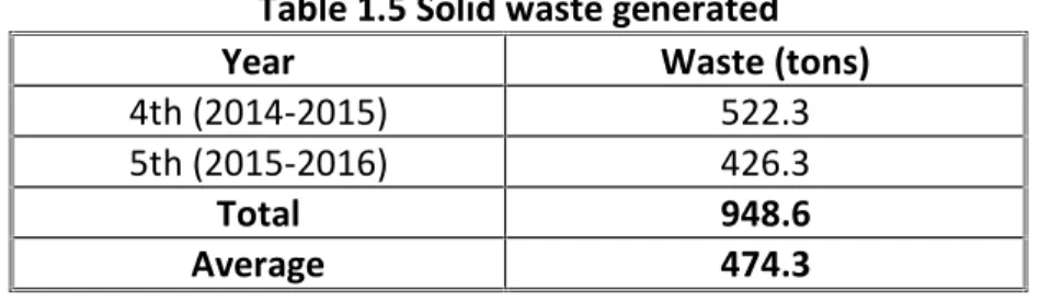
7.2 Solid Waste
During plan period about 948.6tons of waste will be produced. This waste will be stock yard separately at pit bottom and whenever the market comes it will be sold.
Table 1.5 Solid waste generated
Year Waste (tons)
4th (2014-2015) 522.3
5th (2015-2016) 426.3
Total 948.6
Average 474.3
8.0 Site Services
It is also proposed to provide the site services like Mines office and other statutory constructions like rest shelter, first aid, work shed and drinking water as required will be provided in quarry area. Drinking water is supplying to the workers from the bore wells in the adjacent agricultural fields. Office, Rest Shelter, Drinking Water Facilitates, Public Utilities, First Aid are provided by the lessee in the mining lease area.
9.0 Water requirement
Water requirement of 1.8 KLD for the project is mainly for Domestic source, maintaining the green belt and also for sprinkling on the haulage roads to mitigate dust emissions. The water shall be drawn from nearby villages. The water requirement of the project is presented in table 1.6.
Table 1.6 Water Requirement
S. No. Water Usage Quantity KLD
1 Water sprinkling on haul roads @ 1Ltr/Sq. Mt (300m2)+1/4thfor waste dump 0.8
2 Domestic @ 45 Ltr/Head (13 No’s) 0.6
3 Green Belt @ 0.2 KL for 0.03 ha 2 times a day 0.4
Total 1.8
10.0 Environment Management Plan
Environmental protection is an issue that no organization can neglect and hope to survive. The products of civilization are being dumped upon the environment to a degree that the environment finds difficult to assimilate. The key to the success of the integrated approach to pollution prevention and control is the management and operation of the organization. Effective committed management delivers a successful operation. As total commitment to the environment, not just for compliance with legal or regulatory compliance will be the essence of
environment management. Many companies have recognized the benefits of implementing an effective environmental management system.
Environmental management plan can be effectively implemented to mitigate the pollution levels by observing the following:
a. Pollution will be prevented or reduced at the source
b. Pollution that cannot be prevented will be recycled in an environmentally safe manner. c. Pollution that cannot be prevented or recycled will be treated in environmentally safe
manner and
d. Disposal and other releases into the environment will be used only as a last resort and will be conducted in an environmentally safe manner.
The proposed project is Ball clay mine. The mine owners are aware of the adverse impacts due to the mining activity and propose to initiate a number of measures for the environment protection within the mine area and in the surrounding areas. The company has a stated environmental policy of ensuring regulatory compliance with respect to the statutory laws and regulations and those periodically issued by the Ministry of Environment, GOI, New Delhi, CPCB, New Delhi and State Pollution Control Board.
10.1 Sources of Pollution and Control Measures
The sources of pollution are air and noise from the proposed activity mainly from Mining and transportation of mineral. Waste material generation, dumping and restoration.
10.2 Air Pollution and its Control
The Ball clay mining does involve much dust formation. The dust would be generated during mining and also during handling and transportation of the material. Water spraying to be adopted at Faces/sites while loading. Personal protective equipments like nose mask and goggles etc will be provided to the workers. Regular water spraying on haul roads during transportation of mineral and waste by water sprinklers. Over loading of transport equipments should be avoided to prevent spillage. Also, measures such as covering tarpaulin over the loaded material will prevent spreading of dust particles from the trucks. Speed controls on vehicle movements to limited speed. Wind reduction control by plantation. Over burden dump has reached the optimum size, it will covered with top soil and water will spread on top soil and grass will be developed on the dump. Limiting the height and slope of the stockpiles can also reduce wind
control certificate be obtained. Periodical monitoring of ambient air quality will helps to take steps to control the pollutants.
10.3 Noise pollution and its control
The major source of noise pollution is due to vehicular movement. Noise barriers in the form of trees are provided to attenuate the noise levels and green belt of 6m width shall be developed to mitigate propagation of noise. Protective equipment to reduce the noise levels like ear muffs and other protective devices will be provided to the staff working near noise generating sources like dumper drivers. Training would be imparted to mine personnel to generate awareness about the damaging effects of noise. The transport activity shall be restricted to day time to reduce impact on habitation. The engines of the tractors shall be switched off during loading operation, and shall be periodically maintained to ensure low noise levels. Proper maintenance of the equipment will also reduce the noise.
11.0 Occupational Safety and Health
Health and safety aspects of the mine will be taken care off as per the World Bank (WB) guidelines on open pit mining. The guidelines provide the detailed information on the aspects that are required to be taken into account for maintaining proper health and safety issues. The workers continuously exposed to dust will be provided with protective devices like dust mask to prevent respiratory disorders. The workers continuously exposed to a high noise will be provided with ear muffs/ earplugs. Green belt in and around the mining area will be developed to attenuate noise and dust impact. Provisions of rest shelter for mine workers with facility of drinking water supply for the employees will be provided by the project authority. The standard of the drinking water will be per WHO guidelines. Periodical training program to inform the employees about their task, associated risk, and safe working practices will be undertaken. Conduct of mock drill, Safe storage. Training will also include information on accident prevention, proper control and maintenance of equipment and safe material handling practices. Awareness on safety and ensure using of personal protective equipments (PPE) by workers. Regular maintenance and testing of equipments will be done.
A regular monitoring of the Occupational Health and Safety will reduce the chances of accidents in the mine. Records of job related accidents and illness should be maintained. This information will be reviewed and evaluated to improve the effectiveness of Environmental Health and Safety
Occupational Safety and Health to Control Dust Inhalation
Very little dust is expected to be generated during mining and does not affect the environment. It is a small scale mining activity and not much vehicular movement is expected. All the above precautions would be adopted to prevent dust generation at site and to be dispersed in the outside environment. However, for the safety of workers at site, engaged at the strategic locations/dust generation points like loading & unloading points dust masks would be provided. Dust masks would prevent inhalation of RSPM thereby reducing the risk of lung diseases and other respiratory disorders. Regular health monitoring of workers will be carried out.
11.1 Occupational Safety and Health to Control Exposure to Noise
There will not be heavy earth moving machinery which may create some noise pollution. Thus the vibration and noise will be well controlled within permissible limits.
To protect the workers from exposure to high levels of noise, following measures would be adopted:
Provision of protective devices like ear muffs/ear plugs to workers who cannot be isolated from the source of high intensity noise.
Reducing the exposure time of workers to the higher noise levels by shift management. 12.0 Water Quality Management
There is no chemical discharge either from the quarry or from the processing quarry, there will not be water pollution. The proposed quarry workings will not touch the ground water aquifer. The ground water level in this area is 40 m BGL. Maximum depth of the mining will be 12m, flooding by ground water is not anticipated. Hence neither ground water table nor the general surface drainage pattern is affected Hence there will not be water pollution. There will be no change in quality of water. However during rainy months, there is a possibility of wet conditions developing in the working pit this will be minimized, if not altogether eliminated, by adopting simple techniques like digging trenches all round to drain off rainwater and preventing surface run off from entering and flooding working pit. The water from the pits will be pumped by deploying suitable pumps, if and when required, the mine drainage can be effectively managed and the pit kept dry to keep up the production schedule.
12.1 Water Resources
due to mining. The daily water requirement for the mining operations would be approximately 1.8 KLD. Water sprinkling on mine haulage roads etc shall consume 0.8 KLD. For green belt development water consumption is about 0.4 KLD. Domestic purpose is about 0.6 KLD. The water is to be sourced from nearby village through tankers. The generation of wastewater from domestic sources is expected to be approximately 0.5 KLD, which will be sent to septic tank followed by soak pit.
12.2 Water Management
Following measures will be adopted to mitigate the impact on the water resources:
During excavation activities effort must be taken to avoid face collapse at these cracks and fissures.
To prevent surface water contamination by oil/grease, leak proof containers shall be used for storage and transportation of oil/grease. The floors of oil/grease handling area will be kept effectively impervious.
To prevent degradation and maintain the water quality during rainy season, adequate control measures should be adopted to check the mine run-off into the natural streams. 12.3 Catchment Area Treatment Plan
A catchment area treatment plan has been developed keeping in mind the results of the hydrology/ hydrogeology of the area and the climate data. As there are no perennial water sources running on or through the site, the mine water discharge is limited to the monsoon season only. To keep water from entering the mine during this period, a garland drain will be developed along the mine’s top bench, which will bend to guide the water to the nearest natural surface drain.
In terms of water quality, good mining practices are planned, additionally the natural state of surrounding areas, should ensure that rain water run-off from the mine does not contain any toxic elements. As the site has no overburden, potential discharge of sediments is quite limited and any residual particles which are washed down will be captured by a sump located at the lowest bench. The sump will be cleaned regularly and discharge water monitored consistently. If required, based on monitoring, an additional catch pit can be located at the main garland drain. The sump proposed in the bottom bench will be designed based on the peak discharge and will be expanded over a period of time to accommodate the increasing quantum of water discharge.
Presently, the capacity of the sump is designed to hold the entire quantum of peak discharge water for more than 10 minutes. The garland drain shall be provided surrounding the mine area. Garland drain and siltation pond need to be constructed of appropriate size to arrest silt and sediment flows from soil and mineral dumps. The water so collected will be utilised for watering the mine area, roads, green belt development etc. The drain should be regularly desilted and maintained. The garland drain (size, gradient and length) and sump capacity will be designed keeping 50% safety margin over and above the peak sudden rainfall and maximum discharge in the area adjoining the mine site. Sump capacity should also provide adequate retention period to provide proper settling of silt material. The surface water around the mine, and infrastructure will be regularly tested and appropriate control measures adopted in case of any pollutant is detected above the prescribed limits.
13.0 Waste Management plan
The waste generated is negligible during development and production, which will be used for back filling the pits.
14.0 Dump Area
The mineral waste generated during plan period will be dumped in the stock yard in SE of the mining lease area (with in lease area). By the end of lease period about 948.6 tons of waste will be produced and this waste will be dumped in an area of 0.202 ha with in lease area.
14.1 Land Management
Land degradation is one of the major adverse impacts of opencast mining in the form of excavated voids and also in the form of waste dumps. Land reclamation plan must, therefore, be implemented simultaneously with the mining activities.
14.1.1 Land Reclamation
Since the mine is active with mining activity, no reclamation measures are possible in next three years.
14.1.2 Soil Conservation Measures
The top layer of soil overburden with an average depth of 2m will be excavated and will be used for back filling the old mine pits. Top soil, if any will be properly stacked at earmarked dump site with adequate measures and the same will be used for reclamation and rehabilitation of the mined out areas. To prevent soil erosion and wash-off of dump-fines from freshly excavated
Garland drains will be provided around the mine wherever required to arrest any soil from the mine area being carried away by the rain water;
Toe drains with suitable baffles will be provided all along the toe of the soil dumps to arrest any soil from the dump slopes being carried away by the rain water;
Loose material slopes will be covered by mineation by making contour trenches at 3-5 m interval to check soil erosion both due to wind and rain;
Retaining walls (concrete or local stone) will be provided, around the stockpile or wherever required, to support the benches or any loose material as well as to arrest sliding of loose debris.
15.0 House Keeping
Proper housekeeping and cleanliness will be maintained in the infrastructure facilities. Wet mopping will be adopted to conserve water. Sign boards will be provided in the work areas and the road and building highlighting the safety and occupational aspects.
16.0 Transport Systems
Venkatakrishnapuram to Dwaraka Tirumala road is passing at a distance of 0.3 km in North direction. Thimmapuram-Dwaraka Tirumala road is passing at 1.3km in East direction. Bhimadole railway station is at a distance of 15.9 km in south direction. The finished product and waste material is transported by road using trippers. The number of trips will be approximately 2 per day for transportation of mineral and the tripper is covered with tarpaulin. JCB will do the loading of blocks. The materials while transporting do not pose any hazard. Sufficient parking facilities will be provided for vehicles loading and unloading of material. Safety signs will be displayed inside and outside the mine to avoid road accidents.
17.0 Environmental Greening Program
Environmental greening program is an important component of the Environment Management Plan and is an imperative requirement for sink of air pollutants including noise as per the guidelines issued by the Ministry of Environment and forests, Govt. of India. Conceptualization, design and implementation of the proposed activity, taking into account the specific requirement of the proposed mining activity and the site conditions are presented. Green cover in mining area not only help in reducing pollution level, but also improves the ecological conditions and prevent soil erosion to great extent. It further improves the aesthetics and beneficially influences the
The lessee proposes for afforestation in NE border in 7.5m buffer zone also in matured pits after backfilling with an area of 0.03 Ha. The species that have history of good survival and growth under similar site conditions shall be planted.
S. No. Trees Species Common Name Utility
1 Axadirachta Indica Neem Fuel, Timber, Fodder
2 Albizzia Sp. Siris Fodder, Fuel
3 Dalbergia Sissoo Sisham Fodder, Timber
4 Cassia Sp. Amaltaas Fuel, Fodder
5 Pongaamia Pinnata Karanj Fuel, Fodder
6 Gliricidia Sepium - Fodder, Fuel, Timber
7 Inga Dulce Jungle Jalebi Fodder, Fuel, Timber
8 Eucalyptus Teriticornis Eucalyputs Fuel, Timber
9 Holoptella Intergrifolia Kanju Timber, Fuel
10 Annona Squamosa Sharifa Fuel
The shelterbelt will contain species, which act as windbreakers so that the environment within the mine is contained; the planting of different species in rows is envisaged in general in the greenbelt. A dedicated cell in the mine should be established for post plantation care, which include, regular watering, manuring, protective measures etc. Diseased and dead plants should be uprooted and replaced by fresh saplings. Regular monitoring on survival rate and remedial action should be done in an organized and planned manner.
18.0 Socio-economic Environment
The project provides an opportunity for the local people to get employment directly or indirectly and helps in the upliftment of the socioeconomic status of the area. The proposed project would generate an employment of 13. The local inhabitants of the area live in the villages surrounding the mine area and their main occupation is Agriculture. In a small way they rear cattle and sheep for sustenance. The mining activity in this belt will benefit the locals both directly and indirectly. The direct beneficiaries will be those who get employed in the mines as skilled and un-skilled workers. The indirect beneficiaries will be those who open small business to sell goods required by the residents whose “Per Capita” income will be enhanced by the mining activity, and thereby their purchasing power. In the long run a lot of social good is expected in the comparatively backward area when the inhabitants will be able to send their children to school. The change, though slow, is bound to be perceptible.
The management will involve in social activities of stakeholders/surrounding community by planning the betterment of neighboring social conditions through awareness and welfare
programs to ensure an improved relation, useful in the long run. Many of the beneficiaries of such programs will include own employees as well. The goodwill of the local populace can never be ignored. It is proposed to supply drinking water and medical facilities to the villagers. The management will also support for vocational training and assistance in utilizing government programs. The channels employed may vary either through direct contact or by means of local organizations. Another important facet of social environment identified by the project proponents is a green appearance; hence the management will develop a green belt towards aesthetic beautification as the same is necessary to be considered as a responsible, social neighbour.
19.0 Disaster Planning
The mining operation shall be carried out under the management control and direction of a qualified mines manager holding a Second class manager’s certificate of competency to manage a metalliferous mine granted by Director General of mines safety (DGMS). DGMS have been issuing a number of standing orders and circulars to be followed by the mine management in case of disaster, if any. Moreover mining staff would be sent to refresher courses from time to time to keep them abreast of the regulations. However following natural/ quarrying hazards may occur during normal operation
Slope failure at the mine faces;
Accident due to heavy equipment/machinery;
Sabotage in case of magazine; and
In order to take care of above hazards/disasters, the following control shall be adopted:
All safety precautions and provisions of Metalliferous Mine regulation 1961 are strictly followed during all mining operations;
Checking and regular maintenance of garland drains and earthen bunds to avoid any inflow of surface water into mining area;
Entry of unauthorized persons shall be prohibited;
Fire fighting and first aid provisions in the mines office and mining Area;
Provision of all the safety appliances such as safety boots, helmets, dust masks, ear mufflers, goggles etc. would be made available to the employees and regular check to ensure the use;
Training and refresher courses for all the employees working in the hazardous premises;
Suppression of dust on the haulage roads by providing water sprinkling.
20.0 Environment Management Cell
A Cell for Environmental Management within Mine lease area at the project level, will take the overall responsibility for co-ordination of the actions required for environmental management and mitigation, and for monitoring the progress of the proposed management plans and actions to be taken for the project. The Cell will be under the overall supervision of the Mine Manager, and responsible for monitoring of the implementation of the various actions which are to be executed by the agencies specified in the EMP. The Cell will be headed by Mine Manager and the other members of the cell that will include a Horticulturist.
The EMC will prepare a formal report on environmental management and mitigation for the Environmental issues at the Mine, at six-monthly intervals. Reports on any urgent or significant issues may be prepared at shorter intervals. Apart from responsibilities listed above, the EMC will have the responsibility of the following:
Collection of water and air samples within and outside the work zone;
Analyzing the water and air samples;
Implementation of the control and protective measures;
Land reclamation and vegetation;
Co-ordination of the environment related activities;
Collection of the statistics of health of workers;
Green belt development;
Awareness and implementing safety programmes; and Monitor the progress of implementation of EMP. 20.1 Post Project Monitoring
The survey of post project monitoring comprises of the following monitoring aspects; a. Ambient air quality survey
b. Noise Level Monitoring c. Water quality monitoring
Ambient air quality and noise level Monitoring will be carried out at minimum two stations, one station within mine site other nearby residential areas outside the mine. Parameters like particulate matter, sulphur dioxide, oxides of nitrogen carbon monoxide and lead will be monitored in case of ambient air quality. Water quality monitoring will be carried out in the mine
working area, sump and nearby village. The frequency of monitoring is preferably once in three months on 24 hour basis. The samples will be collected in accordance with the procedures given by CPCB.
20.2 Other Management Aspects
Records will be maintained for the analysis of ambient air quality, noise levels and water quality. These records are not only required for the perusal of the Pollution Control Board authorities to take preventive action against the environmental pollution. The management will maintain the records as per the hazardous waste regulations and EPA regulations and apply for the annual consents for air and water, and renewal of authorization for the storage of hazardous waste as per the Hazardous Waste (Handling & Management) Rules, 1989. The records of hazardous waste manifest will be maintained.
The mine will obtain the consent for establishment (CFE) and consent for operation (CFO) from State Pollution Control Board as required under section 25/26 of the Water act, 1974 and under section 21/22 of Air Act, 1981, before commissioning and production as directed by the Hon’ble Supreme Court of India. The CFO will be renewed each year by the management in consultation with SPCB. The mine will submit environmental statement every year before September 30. The management ensures that it will comply with all the directions and regulations issued by the Ministry of Environment and Forests, New Delhi, State and Central Pollution Control Boards. The Consent for Establishment, Consent for Operation will be displayed in a conspicuous location for the information of the inspecting authorities of different departments.
21.0 Cost proposed for Environmental Protection Measures
The cost estimate of environment management is presented intable 1.7. Table 1.7 Environment Management - Cost Estimate S.
No. Description Item cost (Rs.)Capital Recurringcost (Rs.) Remarks
1 Air pollution Nose masks 13 No's 18096 6864 Once a week. Replaceable, and cost may increase with time
Road wetting @ 1 Ltr/300 Sq. m. and waste dump settling (1/4 of
wetting) - 5000 Ltrs tank 9660 2898
Water tanker cost @ one tankers per day for 300 days
Plantation on road side - 3m interval and buffer zone - 3m
interval plus maintenance 8750 4083
Re-plant the non-surviving plants, watering and protection from animals
pollution mine
De-silting operations 27300 6300 Yearly and manual operations Construction of check dams 123360 56540 Once in year, cost incurred is to buy
sand bags and filling sand Construction of retaining wall for
waste dump in slope side 94120 21720 Cost of construction of wall aroundthe dip side of the dump. Sub Total 316228 98300
3 Noise pollution PPE's like Ear muffs - Rs. 15 each 1040 364 Once in six months Sub Total 1040 364
4 Occupational Safety and Health
First aid kits - 2 No's Fire
extinguishers - 2 No's 8000 3600 Once in year, replace by conductingperiodical checkup PPE's to all employees (hand
gloves @ Rs. 30, safety shoe @ Rs.
1500 and helmet @ Rs. 100) 77250 37080
Safety shoe twice in a year, helmets once in three years and hand gloves thrice in a year
Training and awareness programs on risk factors during emergencies
by the experts 10000 5000
Once in six months and create sign boards about the risk and safety precautions regularly
Periodical medical checkup and supply of medicines - Rs. 600 per
head 13000 2652
Once in a year and supply of medicines for every three months Sub Total 108250 48332
5 Environmental
monitoring Ambient air quality studies - Oncein six months - 2 locations - 13600
Will be done through MoEF&CC/NABL recognised
laboratories Water quality studies - Once a year
- 2 Locations - 3000
Noise studies - Once in six months
- 2 Locations - 4400
Vibration studies - Once in year - 1
locations - 7800
Sub Total - 28800 Grand Total 462024 189641