MORROW COUNTY
PRE-DISASTER MITIGATION PLAN
This Natural Hazard Mitigation Plan was developed through a regional partnership funded by the Federal Emergency Management Agency’s (FEMA) Pre-Disaster
Mitigation Competitive Grant Program. The Mid-Columbia Region grant was awarded in the fall of 2005 to support the development of natural hazard mitigation plans for
communities in the region. The County utilized a planning process, plan framework, and plan development support provided by the Oregon Natural Hazards Workgroup (ONHW) at the University of Oregon’s Community Service Center.
u.s.
Department of Homeland Security Region X 130 228th Street, SW Bothell, WA 98021-9796FEMA
December 15,2006 Honorable Terry Tallman, ChairHonorable John Wenholz Honorable Ray Grace
Morrow County Board of Commissioners P.O. Box 788
Heppner, Oregon 97836
Dear Commissioners Tallman, Wenholz, and Grace:
The U.S. Department of Homeland Security's Federal Emergency Management Agency (FEMA) has approved the Morrow County Natural Hazards Mitigation Plan as a multi-jurisdictional local plan as outlined in 44 CFR Part 201. With approval of this plan, the following entities are now eligible to apply for the Robert T. Stafford Disaster Relief and Emergency Assistance Act's hazard mitigation project grants through December 15,2011:
Morrow County City of Boardman City of Heppner City of lone City of Irrigon City of Lexington
The plan's approval provides eligibility to apply for hazard mitigation projects through your state. Grant applications will be evaluated individually according to the specific eligibility and other requirements ofthe particular hazard mitigation grant program. For example, a mitigation project identified in the approved plan mayor may not meet the eligibility requirements for Hazard Mitigation Grant Program funding.
Over the next five years, we encourage your communities to follow the plan's schedule for monitoring and updating the plan, and develop further mitigation actions. Th~plan must be
reviewed, revised as appropriate, and resubmitted for approval within five years in order to continue project grant eligibility.
If you have questions regarding your plan's approval or FEMA's mitigation grant programs, please contact our state counterpart, Oregon Emergency Management, who coordinates and administers these efforts for local entities.
CarlL. Cook, Jr., Director Mitigation Division cc: Dennis Sigrist, OEM
Enclosure
MORROW COUNTY
PRE-DISASTER MITIGATION PLAN
TABLE OF CONTENTS
THE PLAN
SECTION 1 – INTRODUCTION
SECTION 2 – COMMUNITY PROFILE
SECTION 3 – RISK ASSESSMENT SUMMARY
SECTION 4 – MISSION, GOALS AND ACTION ITEMS
SECTION 5 – PLAN IMPLEMENTATION AND MAINTENANCE
ANNEXES DROUGHT EARTHQUAKE FLOOD LANDSLIDE VOLCANO WILDFIRE WIND STORM WINTER STORM CITY ANNEXES BOARDMAN HEPPNER IONE IRRIGON LEXINGTON APPENDICES A – RESOURCE DIRECTORY
B – PLANNING AND PUBLIC PROCESS
C – HOUSEHOLD NATURAL HAZARDS PREPARENDESS SURVEY
D – ECONOMIC ANALYSIS OF NATURAL HAZARD MITIGATION PROJECTS E – EXISTING PLANS, POLICIES, AND PROGRAMS IN MORROW COUNTY F – TOOLS
G – LIST OF ACRONYMS
H – REGIONAL ECONOMIC AND TRANSPORTATION STUDY I – ACTION ITEMS
List of PDMP documents not in electronic form.
Morrow County Resolution R-23-2006 Adoption Resolution
THE PLAN Section 1 – none Section 2 – none Section 3 – none Section 4 – none Section 5 – none ANNEXES
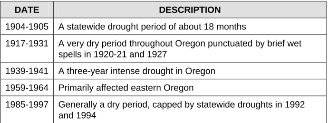
Drought – National Climatic Data Center, NOAA Satellite and Information Service, http://www.ncdc.noaa.gov/oa/climate/research/2005/sep/st035dv08pcp20 0509.html
Office of the Governor State of Oregon Executive Order NO. 05-05 Determination of a State of drought emergency in Crook, Gilliam, Hood River, Morrow, Sherman, and Umatilla counties due to drought and low water tables.
Environmental Assessment Emergency Withdrawal for Irrigation, Willow Creek Lake Morrow County, Oregon
Newspaper Article: East Oregonian, 5/15/2005: Parched soil, low crop yields nothing new in Morrow County
Newspaper Article: East Oregonian, 4/09/2005: Drought declared for Umatilla, Morrow Counties
Newspaper Article: East Oregonian, 6/30/2004: Census: Local Farmers Struggling
Newspaper Article: East Oregonian, 12/23/2002: Morrow County Drought Hits Man, Beast Alike
Earthquake - Map: DOGAMI 7/2006 Preliminary, Morrow County Ground Shake Amplification
Map: DOGAMI 7/2006 Preliminary, Morrow County Relative Earthquake Induced Landslide Susceptibility
Map: DOGAMI 7/2006 Preliminary, Morrow County Liquefaction Susceptibility
Map: Selected Earthquakes for Oregon 1841 through 2002, DOGAMI, 2003
Newspaper Article: East Oregonian, 08/13/2006: Small Quakes Shake Northwest
Newspaper Article: The Hermiston Herald, 04/13/2004: Is Another Major Quake Coming?
Morrow County Emergency Management News Release, 3/24/1997: Earthquake reports sought in Morrow County
Oregon State Police Emergency Management Division report of a 3.9 magnitude earthquake near Maupin, Oregon 3/21/1997
University of Washington Seismology Lab, Earthquake Notification Summary 03/21/1997 near Maupin, Oregon
Oregon Emergency Response System advisory of an earthquake in the Pine City area: 02/13/1996
Newspaper Article: Heppner Gazette Times, 07/16/1936: Temblor Rocks Houses, Rattles Chinaware in Nocturnal Visit
Flood - Morrow County Emergency Management website instructions. The website is: http://www.csepp.org
The Heppner Flash Flood Emergency Plan as Amended May 23, 2006 Flood Hazards, from the website
http://www.heppner.net/city/docs/1999plan.html
Map: FEMA Preliminary Draft of the 100 and 500 year flood zones for the Boardman area
Map: FEMA Preliminary Draft of the 100 and 500 year flood zones for the Heppner area
Map: FEMA Preliminary Draft of the 100 and 500 year flood zones for Ione area
Map: FEMA Preliminary Draft of the 100 and 500 year flood zones for the Irrigon area;
Map: FEMA Preliminary Draft of the 100 and 500 year flood zones for the Lexington area;
Graph: Morrow County Percent of City Area within the 100 year and 500 year Flood Zone;
Executive Order EO-97-09: Determination of a State of Emergency in Coos, Curry, Douglas, Gilliam, Hood River, Marion, Lincoln, Linn, Morrow, Multnomah, Polk, Sherman, Tillamook, Umatilla, Wasco, Washington, Wheeler and Yamhill Counties due to heavy rains caused flooding, landslides and erosion throughout these counties: 01/24/1997
Newspaper Article: Tri-City Herald, 01/04/1997: Flood Losses Add Up While Rivers Recede
Executive Order EO-96-13: Determination of a State of Emergency in Morrow County Due to Heavy Rains and Subsequent Flooding:
Newspaper Article: East Oregonian, 05/26/1971: Flash Flood Roars Through Heppner
Newspaper Article: Heppner Gazette, 06/18/1903: Days of Sorrow in Heppner
Landslide – Map: DOGAMI Preliminary Compilation of Previously Identified Landslides in Morrow County
Volcano - Map: USGS Pacific Northwest Volcanics from website: http://vulcan.wr.usgs.gov/Volcanoes/PacificNW/Maps
Article: “Chicken Little Was Right – Sometimes the Sky DOES Fall” by Katharine Cashman, Phi Kappa Phi Forum/Vol. 86.No.1
Maps: Map of Washington and Oregon showing the percentage probability of accumulation of ten or more centimeters of tephra from a large eruption of Mount St. Helens and the annual probability of
accumulation of ten or more centimeters of tephra in Washington and Oregon from eruptions throughout the Cascade Range.
http://vulcan.wr.usgs.gov/Imgs/Gif
Wildfire - Army Wildland Fire Policy Guidance, August 2002
Interagency Fire Management Plan Template, signed by the USDA Forest Service, Indian Affairs, Bureau of Land Management, Fish and Wildlife Service, and the National Park Service
Executive Order EO-00-18, Determination of Emergency Conflagration Act Due to Fire in Morrow County: 07/22/2000
Executive Order EO-00-24, Determination of Emergency Conflagration Act Due to Fire in Gilliam and Morrow Counties: 08/10/2000
Newspaper Article: Heppner Gazette, 07/22/1987: Wind-whipped Blaze Challenges Volunteer Firefighters
Newspaper Article: Heppner Gazette, 07/30/1970: Blaze Takes Grass and Grain Lands
Wind Storms - Newspaper Article: East Oregonian, 05/20/2006: Severe Weather Strikes Area
Newspaper Article: Hermiston Herald, 05/23/2006: Depot Loses Power Due to Wind Storm
NOAA Damage Report of the May 19, 2006 wind storm from website: http://www.wrh.noaa.gov/pdt/reference/20060519/lsr.php
Article: “The Oregon Weather Book, A State of Extremes” by George H. Taylor & Raymond R. Hatton
Newspaper Article: The Oregonian, 06/14/2006: May Tornado Lashed Morrow County
Newspaper Article: Oregonian, 09/28/1999: Seventh Victim Dies as Result of Highway Crash
Newspaper Article: East Oregonian, 11/20/1999: Freak of Nature? Proper steps would have helped during I-84 pileup, but not much Newspaper Article: East Oregonian, 10/02/2002: Lawsuit Seeks $31 Million for 1999 Dust Storm Death
I-84 Dust Storm Community Solutions Team Final Report – June 1, 2000 Winter Storm – none
CITY ANNEXES (All Action Item Proposals can be viewed in the Action Item Matrix) Boardman - City of Boardman Resolution 8-2006 Adoption Resolution
Action Item Proposal 5.28 Action Item Proposal 5.26
Heppner - City of Heppner Resolution 651-06 Adoption Resolution Action Item Proposal 2.6
Action Item Proposal 2.3, 7.10 Action Item Proposal 7.6
The Heppner Flash Flood Emergency Plan as Amended May 23, 2006 Ione - City of Ione Resolution 6-2006 Adoption Resolution
Action Item Proposals 2.2 and 1.1
Irrigon - City of Irrigon Resolution 06-25 Adoption Resolution Action Item Proposals 1.2, 5.27 and 5.25
Lexington – Town of Lexington Resolution 06-08 Adoption Resolution Action Item Proposals 5.30, 4.2, and 5.31
APPENDICES
A – none
B - Steering Committee sign-in sheet, April 25, 2006 Stakeholder Forum sign-in sheet, May 16, 2006 Steering Committee sign-in sheet, July 11, 2006 Steering Committee sign-in sheet, August 22, 2006 Steering Committee sign-in sheet, September 12, 2006 Flyers for the Open for Business Workshop
C – none D – none
E – Morrow County Telecommunications Plan, January 2001 F – none
G – none H – none
I – All of the original Action Item Proposal Forms are in this appendix J – Maps of the County and city community assets and functions. This
includes one county-wide map and one each of the 5 incorporated municipalities.
Morrow County Pre Disaster Mitigation Plan November 2006 Page 1 of 11
Section 1
Introduction
“
On Sunday, June 14, 1903, at about 5:00 p.m., a cloudburst broke
over the hills south of the small farming community of Heppner.
Overloaded creeks rushed toward the town, picking up debris from the
farms through which they passed. At the south end of Heppner, a
steam laundry crossed the path of the water. Debris built up behind the
laundry, effectively damming the water until the building could not
withstand the pressure. When the water broke free, it hit Heppner with a
force unmatched in the history of the state.
After the floodwaters subsided, the task of finding and burying the
dead began. Bodies were dug out of the debris and, in some cases,
brought back to town from several miles downstream. A temporary
morgue was set up in the stone Roberts Building, one of the few
structures left relatively unscathed on Main Street. Fatality counts
varied; some people simply disappeared and were never accounted for,
some bodies were never identified. The final count was "approximately
250 dead."
(Reprinted from the website: www.rootsweb.com/morrow/HeppnerFlood.htm)Why Develop a Mitigation Plan?
Morrow County developed this Natural Hazards Mitigation Plan in an effort to reduce future loss of life and property resulting from natural disasters such as the flood event mentioned above. The Heppner Flood was the worst flood, in terms of loss of life, ever to occur in Oregon. It is impossible to predict exactly when these disasters will occur, or the extent to which they will affect the County. However, with careful planning and collaboration among public agencies, private sector organizations, and citizens within the community, it is possible to minimize the losses that can result from natural disasters.
A natural disaster occurs when a natural hazard impacts people or property and creates adverse conditions within a community. This plan focuses on the primary natural
hazards that could affect Morrow County, Oregon, which include drought, wildfire, flooding, windstorms, winter storm, and to a lesser extent, landslides, seismic and volcanic events. The dramatic increase of the costs associated with natural disasters over past decades has fostered interest in identifying and implementing effective means of reducing vulnerability. This Natural Hazards Mitigation Plan is intended to assist
Morrow County in reducing its risk from natural hazards by identifying resources, information, and strategies for risk reduction.
The plan is non-regulatory in nature, meaning that it does not set forth any new policy. It does, however, provide: (1) a foundation for coordination and collaboration among agencies and the public in the County; (2) identification and prioritization of future mitigation activities; and (3) assistance in meeting federal planning requirements and qualifying for assistance programs. The mitigation plan works in conjunction with other County, city and state plans and programs, which are:
• The Natural Hazards Element of the Morrow County Comprehensive Plan; • Flood Hazard Overlay Zone of the Morrow County Zoning Ordinance; • City Flood Ordinances
• Morrow County Community Wildfire Protection Plan;
• Mutual Aid Agreements for fire and emergency services between Morrow and Umatilla Counties; and
•
State of Oregon Natural Hazards Mitigation Plan.The plan provides a set of actions to prepare for and reduce the risks posed by
natural hazards through education and outreach programs, the development of
partnerships, and implementation of preventative activities such as land use or
watershed management programs. The resources and information within the
mitigation plan establish a foundation for coordination and collaboration among
agencies and the public in Morrow County, identify and prioritize future mitigation
projects, and assist in meeting qualifications for federal assistance programs.
The actions described in the plan are intended to be implemented through
existing plans and programs within the County.
What is Natural Hazard Mitigation?
What is natural hazard mitigation? Natural hazard mitigation is defined as permanently reducing or alleviating the losses of life, property, and injuries resulting from natural hazards through long and short-term strategies. Example strategies include planning, policy changes, programs, projects, and other activities. Mitigation is the responsibility of individuals, private businesses and industries, state and local governments, and the federal government.i
Engaging in mitigation activities provides jurisdictions with a number of benefits including reduced loss of life, property, essential services, critical facilities and economic hardship; reduced short-term and long-term recovery and reconstruction costs; increased
cooperation and communication within the community through the planning process; and increased potential for state and federal funding for recovery and reconstruction projects.
Policy Framework for Natural Hazards in
Oregon
Planning for natural hazards is an integral element of Oregon’s statewide land use planning program, which began in 1973. All Oregon cities and counties have
comprehensive plans and implementing ordinances that are required to comply with the statewide planning goals. The challenge faced by state and local governments is to keep
Morrow County Pre Disaster Mitigation Plan November 2006 Page 3 of 11 this network of local plans coordinated in response to the changing conditions and needs of Oregon communities.
Statewide land use planning Goal 7 Areas Subject to Natural Hazards calls for local plans to include inventories, policies, and ordinances to guide development in hazard areas. Goal 7, along with other land use planning goals, has helped to reduce losses from natural hazards. Through risk identification and the recommendation of risk-reduction actions, this plan aligns with the goals of the County’s Comprehensive Plan, and helps the County meet the requirements of statewide land use planning Goal 7. The primary responsibility for the development and implementation of risk reduction strategies and policies lies with local jurisdictions. However, resources exist at the state and federal levels. Some of the key agencies in this area include Oregon Emergency Management (OEM), Oregon Building Codes Division (BCD), Oregon Department of Forestry (ODF), Oregon Department of Geology and Mineral Industries (DOGAMI), and the Department of Land Conservation and Development (DLCD).
The Disaster Mitigation Act of 2000 (DMA 2000) is the latest federal legislation
addressing mitigation planning. The legislation reinforces the importance of mitigation planning and emphasizes planning for disasters before they occur. As such, this Act established a pre-disaster hazard mitigation program and new requirements for the national post-disaster Hazard Mitigation Grant Program (HMGP). Section 322 of the Act specifically addresses mitigation planning at the state and local levels. States and local communities must have approved mitigation plans in place in order to qualify to receive post-disaster HMGP funds. Mitigation plans must demonstrate that their proposed mitigation measures are based on a sound planning process that accounts for the risk to the individual and their capabilities.
How was the Plan Developed?
Morrow County Planning Department Staff utilized the University of Oregon Community Service Center’s Oregon Natural Hazards Workgroup, partnered with the Department of Geology and Mineral Industries (DOGAMI) to develop this Pre-disaster Mitigation Plan. The County joined the Partnership for Disaster Resistance and by signing (through the County Commission) a Memorandum of Understanding for this project. FEMA awarded the Mid-Columbia Gorge Region, of which Morrow County is a part, a grant to support the development of the natural hazard mitigation plans for the seven counties in the region.
The planning process used to create Morrow County’s Natural Hazards Mitigation Plan was developed by the Community Service Center’s Oregon Natural Hazard Workgroup at the University of Oregon.ii The planning process was designed to: (1) result in a plan that is DMA 2000 compliant; (2) coordinate with the State’s plan and activities of the Partners for Disaster Resistance & Resilience; and (3) build a network of jurisdictions and organizations that can play an active role in plan implementation. The following is a summary of major activities included in the planning process.
Step 1: Organizing to Prepare the Plan:
Morrow County prepared and developed the Plan with dedicated time of Planning Department Staff. A Steering Committee to help guide the development of the mitigation plan was appointed by the County Court on
March 15, 2006. The Steering Committee was comprised of ten people
representing various agencies and organizations in Morrow County, including: • Gary Neal and Ron McKinnis, Port of Morrow;
• Larry Burns, Irrigon Rural Fire Protection District; • Linda Curtis, American Red Cross;
• Billie Jean Morris, Boardman Chamber of Commerce; • David DeMayo, City of Heppner;
• Mark Burrows, Morrow County School District; • Steve Rhea, Heppner Rural Fire Protection District;
• Janet Greenup, Morrow Soil and Water Conservation District; • Ken Grieb, Morrow County Planning Commissioner; and • Brett Cook, Morrow County Building Official
Additional Morrow County staff input came from the Public Works Department and Morrow County Emergency Management. The Committee was
instrumental in ensuring the success of the development of the Plan as the Committee helped to guide the development of the plan by setting goals, identifying appropriate activities, and developing a process for public participation.
The Steering Committee held the following meetings at the following dates and locations:
• April 25, 2006 Boardman City Council Chambers Agenda items: Introductions
Purpose and Objectives
Review of Morrow County’s Scope of Work PDMP Seven Step Process
Review of “The Plan” Adjournment
• June 6, 2006 City of Heppner, Petty john Building Agenda items: Election of Officers
Re-cap of the Stakeholder Event on May 16 Discussion of the May 19 storm event Goals and Mission Statement
Review of Plan progress
Stakeholder Event – Ratification of Information
Morrow County Pre Disaster Mitigation Plan November 2006 Page 5 of 11 Next Meeting Date and Place
Adjournment
• July 11, 2006 Port of Morrow Sand Hollow Room
Agenda items: Review of Plan Progress: Section 1 Review of Plan Progress: Section 2 Review of Plan Progress: Section 3 Vision Statement Discussion
• August 22, 2006 City of Heppner, Pettyjohn Building
Agenda items: Selection of the Vision Statement
Review and discussion of the Action Items Review of the Draft Plan, Sections 1 - 5 Review of Plan Appendices and Annexes • September 12, 2006 Port of Morrow Sand Hollow Room
Agenda items: The Plan – Where we are and What’s Next What is needed to complete the Plan Motion to Submit Plan for Review
Step 2: Involving the Community:
Citizen involvement in local planning efforts is required by the state of Oregon and during the development of this Plan the citizens of Morrow County provided their expertise, time, and commitment to the process. Community involvement was represented in the form of the Steering Committee, the Stakeholder Forum, and the Stakeholder interviews. The Stakeholder Forum was held on May 16, 2006. At the Stakeholder Forum, each participant provided firsthand, detailed knowledge that was pertinent to risk and hazard identification within each citizen’s area of knowledge. Attendees at the Stakeholder Forum:
Representatives from:
• Tidewater Barge Lines • Finley Buttes Landfill
• U.S. Army Corps of Engineers • Bonneville Power Administration • Union Pacific Rail Road
• Columbia River Processing • Cascade Natural Gas
• Department of Environmental Quality • Oregon Department of Transportation
• Department of Geology and Mineral Industries • U.S. Forest Service
• Town of Lexington, Morrow county Public Works
• Morrow County Health District Morrow County Helarth Department • Morrow County Assessor
• City of Boardman
• Morrow Soil and Water Conservation District • Morrow County Sheriff’s Office
• Heppner, Irrigon and Boardman Rural Fire Protection Districts Morrow County Staff also conducted various Stakeholder Interviews. Each interview was intended to obtain specific information about critical infrastructure or other community assets from Morrow County natural hazard stakeholders listed below: Stakeholder Interviews:
• Bonneville Power Administration – May 16, 2006 • West Extension Irrigation District – June 13, 2006 • City of Irrigon – June 15, 2006
• City of Boardman – June 15 and July 20, 2006 • City of Ione – July 10, 2006
• Town of Lexington – June 26, 2006 • City of Heppner– June 26, 2006
• Oregon Department of Transportation – July 13, 2006 • Irrigon Chamber of Commerce – August 2, 2006 • Heppner Chamber of Commerce – August 10, 2006 • Trans Canada Pipeline – August 22, 2006
• Portland Gas and Electric – August 29, 2006
As part of the regional PDM grant, ONHW implemented a region wide household preparedness survey. The survey gauged household knowledge of mitigation tools and techniques and assessed household disaster preparedness. The survey results improve public/private coordination of mitigation and preparedness for natural hazards by
obtaining more accurate information on household understanding and needs. The results of the survey are documented in the plan’s Resource Appendix.
Morrow County Pre Disaster Mitigation Plan November 2006 Page 7 of 11 The Oregon Natural Hazards Workgroup (ONHW), with commitment from the Institute for Business and Home Safety (IBHS), provided individuals in the Region with access to, and use of, the IBHS interactive, web-based Open for Business property protection and disaster recovery planning tool. The purpose of the planning tool is to: (1) create
understanding of the importance of disaster planning; (2) teach local businesses how to navigate the interactive, web-based Open for Business property protection and disaster recovery planning tool; (3) Assist small businesses develop their own plans during the training; and (4) teach businesses how to communicate the importance of developing and utilizing plans for property protection and recovery from business interruption. In May, 2006 the ONHW conducted the Open for Business Workshop for local businesses in The Dalles and Hermiston. The summary of this workshop can be found in Appendix B.
Step 3: Describing the Community:
The County developed a community profile in an effort to gain a better understanding of the County assets that might be at risk from natural hazards. Using data gleaned from Portland State University Population Research Center, Oregon Department of Revenue, and Oregon Employment Department, and the Morrow County Comprehensive Plan, a profile of the County population was formulated which proved to be invaluable sources for creating an accurate profile of the County’s population. Local data about critical infrastructure and human and natural resources came from the detailed and extensive knowledge of the stakeholders and pre-existing plans and documents. This information can be found in Section 2.
Step 4: Identifying and Characterizing the Hazards Impacting the
Community:
With information gathered from local and State records, the Morrow County Planning Department identified eight natural hazards that have the potential to affect Morrow County. These hazards include drought, earthquake, flooding, landslides, volcano, wildfire, windstorms, and winter storms. These hazards were also identified by the Partners for Disaster Resistance & Resilience, the Oregon Department of Geology and Mineral Industries (DOGAMI), the Oregon Department of Emergency Management, and the experience of Morrow County Emergency Management, the Planning Department, Public Works Department, and the Rural Fire Protection Districts.
The assessment of these risks to Morrow County was conducted by the community participants during the steering committee and stakeholder meetings who analyzed the particular hazards in the County and their likely locations. The Committee and Planning Staff was aided by the Planning for Natural Hazards: Oregon Technical Resource Guide and the State’s Natural Hazard Management Plan Risk Assessment and regional profile. The regional profile was compared against local data, but the County’s vulnerability to natural hazard risk was the result of local expert input and the State resources
mentioned above. The Planning Staff used this information to determine vulnerabilities and provide the factual basis for proposed mitigation actions. Section 3, Risk
Assessment Summary contains the assessments of Morrow County’s vulnerabilities to natural hazard risk in this Plan.
Step 5: Developing Plan Goals:
The basis for Morrow County’s goals concerning mitigation of natural hazard risks lies in the Comprehensive Plan, which directs the County to protect life and property from natural disasters and hazards. This goal of the Natural Hazards Element exists in harmony with many other County planning programs from the Transportation System Plan to the ordinances, plans and policies of the Health Department, Planning
Department, Public Works Department and other entities such as Morrow County Emergency Management. The Steering Committee, with the support of the Planning Department and guidance of the Oregon State’s Hazard Mitigation Plan Goals along with examples of goals from other Oregon counties, considered and developed the natural hazard mitigation plan goals. Section 4, Mission, Goals and Action Items lists Morrow County’s goals for natural hazard mitigation.
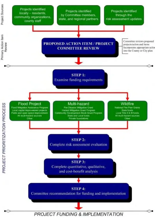
Step 6: Developing Solutions:
The Steering Committee and Planning Department staff evaluated a broad set of mitigation action items for the Plan’s identified natural hazards that could impact the County. These “action items” are recommendations for pre-disaster mitigation given to the County in the PDMP process. Members of the Planning Department Staff, Steering Committee, Public Works Department and the Morrow County Stakeholders identified the action items during the Steering Committee meetings, the Stakeholder event, Stakeholder interviews, and by the PDMP Staff in response to needs identified after the May19, 2006 storm event. Other sources of Action Items are listed as follows:
Other Action Item Sources:
1. City Meetings
2. Meetings with city Chambers of Commerce
All of the Action Items can be found in Section 4, Mission, Goals and Action Items and Appendix I of this Plan.
Step 7: Setting the Plan in Motion:
Planning staff have responsibility for the Plan development through its adoption by resolution by the County Court and each of the respective communities in Morrow County. Once the Plan is adopted the Morrow County Emergency Management Department will take over maintenance of the Plan and implementation of the recommendations (Action Items). The Emergency Management Department will maintain the Plan on the County Emergency Management web site and will be
responsible for holding, at a minimum, annual meetings of the Steering Committee. The Public Works Department will assist with the maintenance and the Planning Department will be available as needed. Planning staff will, of course, be responsible for
implementing those Action Items relative to the Comprehensive Plan, Zoning Ordinance and Subdivision Ordinance.
The Steering Committee, at their September 12, 2006, meeting did recommend that the Plan be submitted for review to the Oregon Office of Emergency Management (OEM) and the Federal Emergency Management Agency (FEMA) for review. Planning staff will make adjustments to the Plan as deemed necessary by the review process. At the time both OEM and FEMA have approved the Plan Planning staff will work with the County Court and each City or Town Council to adopt by resolution the Plan.
Morrow County Pre Disaster Mitigation Plan November 2006 Page 9 of 11
How is the Plan Organized?
Each section of the mitigation plan provides specific information and resources to assist readers in understanding the hazard-specific issues facing Morrow County citizens, businesses, and the environment. Combined, the sections work together to create a mitigation plan that:
• furthers the County’s mission to identify and reduce risk, and
• works to prevent loss and protect life, property and the environment from natural hazards.
This plan structure enables stakeholders to use the section(s) of interest to them.
Section 1: Introduction
The Introduction briefly describes the County’s mitigation planning efforts and the methodology used to develop the plan. It also includes information about the steering committee’s role, and how stakeholders provided input.
Section 2: Community Profile
The Community Profile briefly describes the County in terms of demographic, economic, and development trends as well as geography and environment, housing and
transportation. The Community Profile also documents existing plans, policies, and programs, as well as completed mitigation activities.
Section 3: Risk Assessment Summary
This section describes the risk assessment process and summarizes the best available local hazard data. It is organized according to federal requirements for risk assessment: hazard identification; profiling hazard events; and vulnerability assessment/inventorying assets.
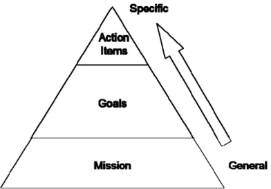
Section 4: Mitigation Plan Goals and Action Items
This describes the plan components that guide implementation of the identified mitigation strategies. This section also documents the plan vision, mission, goals, objectives, and actions.
Section 5: Plan Maintenance
This section provides information on the implementation and maintenance of the plan. It describes the process for prioritizing projects, and includes a suggested list of tasks for updating the plan to be completed at the annual and 5-Year review meetings.
Hazard Specific Annexes
The purpose of the hazard specific annexes is to provide additional resources and documentation of the hazard. The hazard annex consists of the regional risk assessments from the State Natural Hazard Mitigation Plan as well as the hazard chapters from the Technical Resource Guide. The State regional risk assessments include information on hazard characteristics, hazard history, probability, and vulnerability. The Technical Resource Guide chapters provide hazard specific
information on a statewide basis for the following topics: hazard history, hazard type and characteristics, hazard identification, hazard related legal issues, mitigation examples and best practices, and resources. Where extensive local data is available beyond the scope of information provided in Section 3, the additional local data, including the City Annexes are located in the annex. In addition to the State Risk Assessment and Technical Resource Guide information, the Earthquake Annex also includes a seismic risk assessment report provided by DOGAMI. The hazard specific annexes included with this plan are the following:
• Earthquake; • Flood; • Landslide/Debris Flow; • Volcanic Event; • Wildfire; • Windstorm; and • Winter Storm.
City Annexes
This annex contains the summaries of participation by the cities, special hazard information particular to the cities, the city Action Items, and copies of the citys’ Resolutions of Adoption of this Plan.
Resources Appendices
The resource appendices are designed to provide users of the Morrow County Natural Hazards Mitigation Plan with additional information to assist them in understanding the contents of the mitigation plan, and provide them with potential resources to assist with Plan implementation. The resources include:
Resource Directories for State and County Multi-Hazard, Flood, Wildfire and Landslides Mitigation Resources
This appendix includes local, regional, state and federal resources for some of the hazards addressed in the Plan. The directory also includes key publications and additional resources. The Community Service Center’s Oregon Natural Hazards Workgroup at the University of Oregon Natural Hazards Workgroup at the University of Oregon developed this appendix.
Planning and Public Process
This appendix includes evidence of the public process involved in the development of this Plan. Steering Committee attendance, meeting minutes, agendas are included. The Stakeholders and stakeholder interview summaries, as well as the Open for Business Workshop summary are all included.
Regional Household Preparedness Survey
This appendix includes the survey instrument and results from the household
preparedness survey implemented by ONHW throughout the region. The survey aims to gauge household knowledge of mitigation tools and techniques to assist in reducing the risk and loss from natural hazards, as well as assessing household disaster
preparedness.
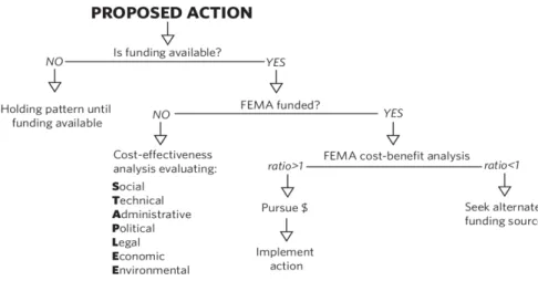
Economic Analysis of Natural Hazard Mitigation Projects
This appendix describes the Federal Emergency Management Agency’s (FEMA) requirements for benefit cost analysis in natural hazards mitigation, as well as various approaches for conducting economic analysis of proposed mitigation activities.
Morrow County Pre Disaster Mitigation Plan November 2006 Page 11 of 11
Existing Plans, Policies, and Programs
The existing plans, policies and programs in Morrow County are listed in this appendix. The first section covers plans and policies on the books for the County and the second section covers social service providers.
Tools
This appendix describes various tools and techniques that can help communities reduce risk from natural hazards. A brief examination of the effectiveness and limitations for each tool is included.
List of Acronyms
This appendix provides a list of acronyms for county, regional, state and federal agencies and organization that may be referred to within the Morrow County Natural Hazards Mitigation Plan.
Mid-Columbia Natural Hazard Risk Profile
This report is part of the State’s enhanced natural hazard mitigation plan. It is intended to be used as a planning process document by communities developing local natural hazard mitigation plans and during periodic review and update processes.
Action Items
Located in this appendix are the original Action Items submitted to the County during the development of the Plan.
Maps
This appendix holds the maps used by the Stakeholders and the Steering Committee to identify Morrow County Assets and Functions pertinent to the County’s natural hazard risks. The Assets and Function are divided as follows: human population, economic assets, cultural & historic resources, infrastructure & critical facilities, and environmental.
i Massachusetts Department of Environmental Management. 1999. “Hazard Mitigation: Managing Risks, Lowering Costs.
http://www.state.ma.us/dem/programs/mitigate/whatis.htm Accessed 8/2/02
ii More information on the Oregon Natural Hazards Workgroup can be found at
Section 2
Community Profile
This section provides information on the characteristics of Morrow County, in terms of demographic, economic, and development trends as well as geography and environment, housing and transportation. Many of these community characteristics can affect how natural hazards impact communities, and can affect howcommunities choose to plan for natural hazard mitigation. Considering these characteristics during the planning process can assist in identifying appropriate measures for natural hazard mitigation.
Geography and Climate
Morrow County lies along the Columbia River with 35 miles of shoreline, almost midway between the eastern and western boundaries of Oregon. Morrow County has an elevation at its highest point of 6000 feet in the mountains south of Heppner to 260 feet above sea level at the Columbia River to the north. The County contains 1,321,600 acres of land of which 40 percent is range land, 35 percent cropland and 18 percent is forested. It is part of the 100,000 square-mile Columbia Basin Plateau between the Rocky Mountains and the Cascade Range in Washington, Oregon, and Idaho. Most of Morrow County is underlain by the Miocene Columbia River Basalt Group rocks, which were deposited in large lava flows sometimes hundreds of feet thick. The Columbia Basin was also the scene of the Missoula Floods which were the greatest catastrophic floods ever documented in the geologic record. The area that became north Morrow County participated in this event, as the Columbia River was the drainage for these catastrophic floods. The climate is relatively dry because the Cascade Mountains serve as an effective moisture barrier causing storms to dump much of their moisture west of the peaks leaving areas to the east, including Morrow County, in a “rain shadow.” This region has a definite winter rainfall climate. The months of November through February generally receive the most precipitation due to winter storms, which bring rain to lower elevations and snow to higher areas characteristic to the southern portion of the County. Annual totals vary and are proportional to elevation; the average annual rainfall for Boardman in the northern and lower portion of the County is 8.61 inches while Heppner, which is a part of the higher areas, receives 10.44 inches annually.
Occasional summer thunderstorms bring localized, occasionally heavy rain. The County is part of the Umatilla Drainage Basin, which flows into the Columbia River. The Butter Creek in Morrow County is tributary to the Umatilla River, which flows into the Columbia River. The Willow Creek, whose headwaters are in the mountains above Heppner, flow through the communities of Heppner, Lexington and Ione, and joins the Columbia River just outside of Morrow County to the west. There are other minor drainages, which flow into the Willow Creek, which have been locally renowned for periodic flash flooding such as Balm Fork, Hinton Creek, Rhea Creek, and Shobe Creek.
Morrow County Pre-Disaster Mitigation Plan November 2006 Community Profile Page 2 of 14 The County has sedimentary deposits generally less than 100 feet thick, some of
which are wind-deposited loessial soil which support extensive wheat farming. Where the deposits are thin or discontinuous, they provide grazing for cattle and sheep. In the northern portion of the county are deposits left during the glacial melt water transport of the Missoula Floods. They are the primary type of sedimentary deposits present there and are generally less than 100 feet thick and support the extensive irrigated agriculture present in the northern portion of the County.
Population and Demographics
Permanent settlements in what would become Morrow County were established in the canyons of Willow and Butter Creek before 1870. In August of 1872 Henry Heppner and Jackson Lee Morrow opened a store on Stansbury Flat near the forks of Willow Creek to service the needs of the stockmen settled on Willow Creek, Balm Fork, and Rhea Creek. These stockmen were tired of hauling goods themselves from the Columbia at Umatilla Landing or Castle Rock. Sheep were the chief product of the Morrow County rangelands which eventually changed to a grain-based economy after the establishment of National Forest lands, grazing restrictions and the spread of sagebrush onto the grasslands. The population slowly grew through the twentieth century despite economic hard times in the 1930s and the need for the young people to look for work outside of the County if they weren’t interested in the farming
profession. During the 1950s and 1960s Heppner’s population grew due to the post WWII baby boom and employment opportunities at the sawmill. The next two decades saw the introduction of irrigated agriculture and the formation of the Port of Morrow in the northern portion of the County. Portland Gas and Electric developed a coal fired power plant in the Boardman area and the population in the northern part of the County began to rise due to the need for agricultural and industrial workers. Morrow County experienced a higher growth rate than the overall Umatilla/Morrow County region, which averaged 1.8 percent from 1998 to 2004. During the same time period, Morrow County managed a population growth rate of 2.4 percent, which meant an increase of more than 3,900 residents in that time period, pushing its total to 11,750 in 2004. Morrow County’s growth over the past 16 years was well above the 1.19 percent Oregon trend. Most of the population in the County has remained within the boundaries of the incorporated cities (average 60%) over the last 25 years.
Morrow County has four incorporated cities and one town as listed below: City of Heppner Population in 2004: 1420
City of Boardman 3120
City of Ione 340
City of Irrigon 1790
Town of Lexington 260
The cities of Boardman and Irrigon are situated in the northern portion of the County next to the Columbia River and contain 42 percent of the County’s population. The cities of Heppner, Ione and the Town of Lexington are situated in the southern portion of the County along Willow Creek and contain 17 percent of the County’s population. This points to the fact that most of the population of Morrow County lives in the northern third of the County.
The impact in terms of loss and the ability to recover vary among population groups following a disaster. Historically, 80% of the disaster burden falls on the public. Of this number, a disproportionate burden is placed upon special needs groups, particularly minorities and the poor.
Population By Age
The Morrow/Umatilla County region aged considerably during the 1990s, with the baby-boom generation – ages 40 to 59 years – swelling its ranks by nearly 7,000 (+48%) from 1990 to 2000. Young adults, however, posted tepid growth, and the region’s 20-to-29 age group was up just 2,095 people (+10.5%). Those 60 and older gained only 996 (+8.3%) over the decade. Children and teens aged 19 and under grew by nearly 4,700 over the 10-year period, for an increase of 22.5 percent. Compared with the state’s 2003 age class distribution, this region had a noticeable lead in children and teens, which represented 30.4 percent of its population total, compared with 27.1 percent for the state. Oregon had a slight lead over the Morrow/Umatilla region in retirement age groups and young adults. The state was nearly two percentage points ahead of the region in the 40-to-59 group, which represented 28.5 percent of Oregon’s 2003 population total compared with 26.7 percent in the region.
Minorities
The Morrow County region’s population diversified greatly during the 1990s. The biggest change was in the Hispanic ethnic group, which gained population. Hispanics represented about 9 percent in 1990 and in 1999 their share had grown to 24.5 percent. The Hispanic population in 2003 had grown to 27.6 percent. The White racial group declined from an 89.1 percent share of the region’s 1990 population to 74.9 percent in 2000. The White population in 2003 was down to 70 percent. The black group showed a total of 35 which represented about .3 percent in 2003.
Morrow County race/ethnicity (2003):
White 70.0%
Black 0.3%
American Indian 1.7%
Asian/Pacific Islander .6%
Hispanic 27.6%
Poverty rates and Disabled populations
According to the 2000 Census, Morrow County grew 44.2 percent between 1989 and 1999. The U.S. Census Bureau determined the poverty status of 10.910 County residents and found that 14.8 percent (1,617 people) lived below the poverty threshold. This was an increase of 10.1 percent in the number of persons living in poverty (1,141 people) since 1989. The overall percent of Morrow County’s
population living in poverty remained relatively constant from 1989 to 1999, but the number of people living in poverty did not. In the 20 years after 1979, the poverty rate in Morrow county increased from 10.5 percent of the population to 14.8 percent. The number of persons in poverty rose from 782 people to 1,617 people. Morrow
County’s poverty rates were higher than the state and national poverty rates from 1989 to 1999 due to increases from 1979 to 1989.
Morrow County Pre-Disaster Mitigation Plan November 2006 Community Profile Page 4 of 14 White residents comprised the majority of people in poverty at 57.6 percent but when examining poverty based on race, the poverty rate among the total white population in Morrow County was 11.4 percent. Hispanics below the poverty level were 45 .3 percent and 27.4 percent of the Hispanic population as a whole.
According to the Social Security Administration data on the December 2003 beneficiaries as a percentage of County Population, 1,660 people received Social Security benefits in Morrow County. That represents 14 percent of the County
population as a whole. Of this group, 71 percent are Retired Workers, 13 percent are Survivors and 16 percent are Disabled. Seven percent of the beneficiaries are children.
Total Retired Workers Survivors Disabled 1660 1179 216 265
Employment and Economics
The first entrepreneurs in Morrow County were the sheep herders who took
advantage of the virgin grasslands in the area as open pastureland in the early 1870s. Not long afterward, Henry Heppner and Jackson Lee Morrow opened a store and a real economy was born. The portion of Morrow County first settled were the areas around the Oregon Trail and Willow Creek. The Oregon Trail came almost straight west from Pendleton through what would later become north central Morrow County. Commercial and financial establishments proliferated in Heppner during the decade of the 1870s and the census-taker counted 318 citizens in the city in 1880. The Oregon-Washington Railroad & Navigation Company, which would eventually become the Union Pacific Railroad, completed their The Dalles to Wallula line in April of 1881 and a branch to Heppner was put in by 1889. When Morrow County was established in 1885 Heppner won the contest with Lexington for County seat. The economic basis of the Heppner area continued to be sheep production with the addition of logging from the 1880’s until the Depression in the 1930s when all but the largest grazing operators went away. By 1939 Highway 74, the Heppner Highway, from Lexington and Heppner along Willow Creek through Lena east towards Pendleton had been built. The rail spur going north from Heppner to the Willow Junction at the Columbia River helped to encourage wheat farming and the farmers began to look to the north for more land but the northern portion of the County was, in the early years, relatively unpopulated.
The economics of the County began to change when irrigated agriculture was developed in the northern portion of the County and the Port of Morrow opened for business in 1957. The Cities of Boardman and Irrigon started to expand as the demand for workers at the Port and on the farms began to grow.
Current Economic Base
Northern Morrow County is dependent on large-scale corporate agri-business, which can be traced to 1963 when the Boeing Company leased 100,000 acres of land south of Boardman and pioneered circle irrigation in this region. This property continues to
be in agricultural production, which includes the production of wheat, potatoes, alfalfa and milk. The Port of Morrow also hosts many large agri-businesses including those for the production of French fries, dried onion production and dairy products. Other significant contributors to the County’s tax base are the regional solid waste landfill located in north Morrow County and the PG&E coal fired electrical plant south of Boardman and co-generation plant at the Port of Morrow. According to the Oregon Employment Department Regional Profile Occupational Employment in Region 12, Morrow and Umatilla Counties workforce analysis, the service industry, health care and farm workers were the top growing occupations. Declining occupations were found in the blue-collar occupations reflecting the restructuring of work places and processes and the loss of manufacturing jobs. The service industry represented the largest percentage of the employment in Region 12. According to the U.S. Bureau of the Census, Census 2000, there are 4,635 employed civilian workers ages 16 and over in Morrow County. Of this pool of workers, 69.7 percents of them are private wage and salary workers; 19.4 percent are government workers, and 10.6 percent are self-employed workers in own, not incorporated businesses.
Housing in Morrow County
Housing development types and year-built dates are important factors in mitigation planning. Certain housing types tend to be less disaster resistant and warrant special attention: mobile homes, for example, are generally more prone to wind and water damage than standard stick-built homes. Generally the older the home is, the greater the risk of damage from natural disasters. This is because stricter building codes have been developed following improved scientific understanding of plate tectonics and earthquake risk. For example, structures built after the late 1960s in the Northwest and California use earthquake resistant designs and construction techniques. In addition, FEMA began assisting communities with floodplain mapping during the 1970s, and communities developed ordinances that required homes in the floodplain to be elevated to one foot above Base Flood Elevation. Housing characteristics provided by the U.S. Bureau of the Census, Profile of Housing Characteristics 2000 for Morrow County are listed as percentages as follows: Single Family: 51%, Multi-Family: 10%, Manufactured Homes: 36%, and Other: 3%. Local data collected from the County Assessor’s office has the information as follows:
Housing Type
Single Family Multi-Family Manufactured Homes
Other
48.5% 2% 49.5% 0%
Housing – Year Built
Pre-1939- 1959 1960 - 1979 1980 - 2000
Morrow County Pre-Disaster Mitigation Plan November 2006 Community Profile Page 6 of 14 Local data collected from Zoning Approvals in the unincorporated areas of the County suggest the ratio of manufactured homes to stick-built homes is higher in north
Morrow County. Eighty four percent of the new dwelling approvals were for
manufactured homes in Morrow County in the years 1990 through 2005 and most of them were in the northern portion of the County. The southern portion of the County has the highest ratio of pre-1939 to 1959 built houses with the majority of the houses being stick-built. In general, the housing in the southern portion of the county is older and stick-built versus the northern portion of the County where the housing is newer and has a higher manufactured home ratio.
Land and Development
Morrow County has an acknowledged Comprehensive Plan and Zoning and Subdivision Ordinances, which are in compliance with Oregon’s land use laws. Morrow County’s Comprehensive Plan and land use Ordinances provide opportunities for citizens to achieve their land use and property development objectives in
accordance with Oregon State law.
Potential for Rural and Urban Development:
The latest Oregon Office of Economic Analysis data, based on the 2000 census, estimates that the population in the County will increase by 54 percent to 18,100 by the year 2025, an average annual increase of about 2.5 percent. The Office of
Economic Analysis publishes population estimates by County out to the year 2040. In percentage terms, Morrow County ranks in the top three counties in the state for projected population growth over five of the eight 5-year periods from 2000 to 2040, and no lower than the top five over the entire 40-year period.
In evaluating potential development of existing land uses and population as well as its distribution, two types of development are considered. One is growth in residential housing development. This will likely take the form of new subdivisions on currently vacant land within an Urban Growth Boundary. These vacant parcels are distributed largely south and west of Irrigon and south and west of Boardman. Additional residential development outside of the Urban Growth Boundaries will be limited because the County enforces a two-acre minimum for residential development in rural residential zones.
The other opportunity for growth is through economic development led by expansion of Port of Morrow industrial facilities throughout the County. The Port, through its 30-year history, has developed a significant inventory of developable land at its three industrial park sites: The Boardman Industrial Park, located east of Boardman and north of U.S. Highway 730; the Airport Industrial Park, located west of Tower Road; and the South Morrow County Industrial Park, located at the Kinzua sawmill complex just outside of the City of Heppner. The City of Heppner is currently evaluating the need for an expansion of its urban growth boundary to accommodate more industrial lands along the Highway 74/207 corridor.
Development Trends
Building permit data for the last four years has averaged about 85 structural building permits per year. This number includes new manufactured home installation and all other structures including commercial buildings, and stick-built houses. The trend has been as follows:
Building Permits Issued:
2001 2002 2003 2004 2005 102 128 102 88 66
Generally, development in the southern portion of the County has been driven by recreation activities such as hunting and use of the off-road-vehicle park operated by the County. Morrow County expects to see further interest in development with focus on the recreation industry.
The northern portion of the County is expected to see further agri-industrial and energy related development. There is interest in the expansion of the dairy industry, biofuels, and wind energy development. The northern portion of the County will also see continued interest in the development and/or further use of the Boardman Bombing Range and the Umatilla Army Depot.
Natural Hazards and Development
The natural hazards that could affect the developing areas of Morrow County are most likely to be wildfire, winter storms and drought in the southern portion of the County. It is expected that as people establish residences in the County’s forested lands, there will be a significant increase in threats to life and property in these areas. During winter storms, the roads and highways of southern Morrow County can
become temporarily impassible due to snow or ice accumulation.
The farmers, as well as local businesses that rely on the well being of the local farming economy of north and south Morrow County, are affected by a prolonged regional drought. The farmers experience reductions on water use imposed by water right restrictions and lowered water tables. Dryland farmers without access to
irrigation systems have to rely on assistance programs in order to survive prolonged drought situations. In turn, the local businesses feel the belt-tightening by the farmers as they buy fewer products and services in the local area.
Development in the northern portion of Morrow County is less affected by natural hazards. Wildfire would be within undeveloped shrub-steppe areas and in dry wheat fields. Drought would worsen a wildfire situation. Flooding in the northern portion of Morrow County is controlled by the dam systems on the Columbia River, but the road systems have not been immune to local flooding situations due to summer and spring storm events. The movement of agricultural and industrial products from Morrow County on the transportation systems leading to the west and east could be potentially affected by winter storms or other events such as a volcanic event occurring in the wider mid-Columbia region.
Morrow County Pre-Disaster Mitigation Plan November 2006 Community Profile Page 8 of 14
Transportation and Commuting Patterns
Road and Highway Transportation
Morrow County is connected to the federal interstate highway system via Interstate 84, which parallels the Columbia River in the north end of the County. Interstate 84 links the County to I-5 to the west through Portland, and to I-80 and I-15 to the south and east to Boise and Salt Lake City. Interstate 84 also links the County to I-82 north to the Tri-Cities in Washington State. Other state highways within the county include: • U.S. 730 serving Irrigon and the Port of Morrow and providing a link between
I-84 and I-82 at Umatilla;
• State Highway 74, the Heppner Highway, which crosses the middle of the County from east to west serving Ione, Lexington, and Heppner;
• State Highway 207, which cross the County from north to south through Butter Creek Junction, Lexington, Heppner, and Hardman and into Wheeler County; • State Highway 206, which crosses the southern portion of the County from
Gilliam County through Ruggs to Heppner.
Bridges:
The following table represents Morrow County’s bridge inventory: State Highway Bridges County Highway Bridges City/Municipal Bridges Historic Bridges 60 51 12 1
The historic bridge is the Spring Hollow Road bridge on Upper Rhea Creek, which was built in the early 1900s. This bridge continues to provide a link for farmers to highways 207 and 74. It is estimated that approximately 60,000 bushels of grain and 1,000 head of cattle move over this bridge annually.
Morrow County residents use the highway system to drive to work either in the local economy or within the larger “laborshed.” A laborshed is the area or region from which an employment center draws its commuting workers irrespective of natural or political boundaries. In this case the regional commuting area includes Gilliam County, Umatilla County and Benton and Franklin Counties across the Columbia River in Washington State. According to the 2000 U.S. Census, Morrow County sent 1,305 workers to Umatilla County, which was a significant 28.9 percent share of its 4,517 resident workers.
Not only do workers travel to other regional areas to their jobs, shopping opportunities are extremely limited in the County for all but basic necessities. Most people travel
out of the County for the more varied shopping opportunities offered in Hermiston in Umatilla County and the Tri-Cities area in Washington State.
The road system in Morrow County generally follows drainage corridors in the
southern portion of the County and is straight and rolling in the northern portion of the County. The Morrow County Transportation System Plan identifies safety issues for the transportation network in the County. The first is the need for an alternative to U.S. 730 for circulation between Irrigon and Boardman in the event of an emergency at the Umatilla Army Depot or the Port of Morrow. The second is the need for an additional north/south connection between Boardman and Ione in addition to Bombing Range Road, which is the only existing connection that wholly lies within the County. A second north/south route would provide an alternate for emergency vehicles and a fire break in the middle portion of the County where there is the potential for large losses due to a wildfire in the wheat fields and desert grasslands pushed by prevailing easterly winds.
There is no community bus service in the County, but the Greyhound Bus service traverses the County on Interstate 84. Local travelers who wish to use a Greyhound bus must board in Stanfield in Umatilla County or Pasco in Washington State. The closest stop to the west is in Hood River.
Evacuation Routes
Morrow County participates in the Chemical Stockpile Emergency Preparedness Program (CSEPP). This federal program is in response to the need in this region to have a response plan for the activities at the Umatilla Chemical Depot, an ordnance facility for storing conventional and chemical munitions. The Morrow County
Emergency Operations Plan, designed for emergencies during the incineration of the munitions stored at the Depot, includes response planning for manmade and natural disasters. This Plan includes evacuation routes in the northern portion of the County during an emergency at the Chemical Depot.
Rail Transportation
Morrow County is served by one national freight rail carrier, the Union Pacific
Railroad. Union Pacific provides freight rail service from Chicago west to the Pacific Ocean. The Port of Morrow operates a rail spur at their Boardman location, which is serviced by Union Pacific.
River Transportation
Morrow County’s location on the Columbia River provides direct access to the Columbia River transportation system, one of the most modern intermodal
transportation networks in the country. This commercial waterway extends from the Pacific Ocean over 465 miles into eastern Washington and Idaho, and includes eight dam and lock complexes. This transportation system is accessed through the Port of Morrow in the Boardman area and the Morrow County Grain Growers access at the end of Paterson Ferry Road.
Morrow County Pre-Disaster Mitigation Plan November 2006 Community Profile Page 10 of 14
Air Transportation
Morrow County has two public airports. The Lexington Airport is approximately one-half mile from the center of the Town of Lexington on a plateau approximately 200 feet above town. Highway 207 passes immediately east of the airport and serves as the primary surface access route to the airport. According to information contained in the 2001 Airport Layout Plan Report, the Lexington Airport site has been in aviation use since early 1945. The Lexington Airport has been a base for agricultural spraying operators for many years in addition to accommodating general aviation, business, medevac, and charter activities. The Lexington Airport has one paved, lighted runway (8-26), which is oriented on a 080-260 degree magnetic alignment and is approximately 4,300 feet long. The airport has been owned and operated by Morrow County since 1960.
The Boardman Airport is located approximately five miles west of Boardman and is accessed from Tower Road off of Interstate 84. The Boardman Airport has a single paved and lighted runway, which is oriented on a 040-220 degree magnetic alignment and is approximately 4,200 feet long. Historically the Boardman Airport has served military aviation and a variety of general aviation users including agricultural aviation. The Boardman Airport sits directly under the Boardman Military Operations Area and Restricted Area which means that aircraft operating at Boardman Airport must avoid flying into these areas of controlled airspace unless permission is granted in advance by the controlling agency (U.S. Navy). Three major electrical Bonneville Power Authority (BPA) transmission lines are located between the runway and Interstate 84 along a 300-foot wide easement. The Boardman Airport is owned and operated by the Port of Morrow.
Natural Hazards and Transportation Patterns
Morrow County experiences disruptions to the transportation system due to the following factors:
1. flooding due to heavy rain storms on roads and highways;
2. impassable conditions due to winter ice/snow storms and extreme cold weather;
3. heavy tumbleweed (Russian thistle) accumulation in roads due to windstorms over agricultural areas with heavy growth of
tumbleweeds.
Critical Facilities and Infrastructure
Critical facilities are those that support government and first responders’ ability to take action in an emergency. They are a top priority in any comprehensive hazard
mitigation plan. Individual communities should inventory their critical facilities to include locally designated shelters and other essential assets, such as fire stations, and water and waste treatment facilities. Listed below are the critical facilities in Morrow County:
Pioneer Memorial Hospital is located in Heppner, which is also the location of the Morrow County Health District's Emergency Medical Services. The Morrow County Emergency Medical Services include six ambulance vehicles located at four separate dispatch sites. Two vehicles are located in Heppner, two in Boardman, and one each in Irrigon and Lexington. The community of Ione has a First Response Vehicle. In a medical emergency, south Morrow County residents are transported to Pioneer Memorial Hospital in Heppner where Trauma Level IV services are available. If
necessary, patients can be flown via helicopter or fixed-wing aircraft to higher levels of trauma care in: Bend, Oregon; Portland, Oregon; or Walla Walla, Washington. Patients in the north end of the county can be transported to Trauma Level III services in
Hermiston, or to higher level care centers if needed.
The Morrow County Sheriff’s office is located in Heppner. Law enforcement services are provided by the County Deputies to the Cities of Heppner, Lexington, Ione, and Irrigon. The Sheriff’s office has two satellite locations, one in Irrigon and one in Boardman. The City of Boardman provides law enforcement services for its citizens within the Boardman city limits.
Within Morrow County there are two incorporated cities with fire departments, Heppner and Lexington. Both are operated with volunteer fire fighters. In addition, there are six rural fire protection districts within the County which are Heppner, Ione ,Irrigon,
Boardman, S. Gilliam, and Pilot Rock Rural Fire Districts. In the Rural Fire Districts, there are only three paid full time fire fighters, the rest are strictly volunteer. The Oregon Department of Forestry, Morrow County and the U.S. Forest Service and Bureau of Land Management protect the forested portions of southern Morrow County under a “closest forces” concept. The Oregon Department of Forestry and the U.S. Forest Service have mutual aid agreements with the rural fire districts within Morrow County that allows for assistance to be provided regardless of jurisdiction.
The power generation plants in Morrow County are coal-fire plant about 20 miles south of Boardman and the Coyote Springs co-generation facility at the Port of Morrow site near Boardman. Both are owned and operated by Portland General Electric. The Boardman facility coal fired plant is a 348.2 MW coal fired facility and Coyote Springs is a 241 MW, natural gas-fired generating facility.
Among the dams in Morrow County, the Willow Creek dam is the most well-known. It’s construction was completed in 1983 and was the first major dam constructed in the United States using the roller compacted concrete technique. Built to prevent the reoccurrence of the disastrous 1903 flood, it controls the flow of Willow Creek and Balm Fork above Heppner. Other dams in Morrow County include the Carty West Dam, which provides water to the PGE Boardman coal fired plant, Cutsforth Dam, and Lake Penland Dam.
Hospitals Hospital Beds Police Stations Fire & Rescue Stations School Districts Power Plants # of Dams # of Dams with Threat Potential 1 12 2 5 2 2-1050 MW 10 1 high threat