Appendix D
HIGHWAY
417
EXPANSION,
OPERATIONAL
IMPROVEMENTS AND
INFRASTRUCTURE
REHABILITATION
From
Nicholas
Street
to
Ottawa
Road
174
Detail
Design
G.W.P.
4091
‐
07
‐
00,
4320
‐
06
‐
00
&
4157
‐
11
‐
00
CLASS
ENVIRONMENTAL
ASSESSMENT
FOR
PROVINCIAL
TRANSPORTATION
FACILITIES
(GROUP
B)
PUBLIC
INFORMATION
CENTRE
SUMMARY
REPORT
March
2012
Ottawa,
Ontario
HIGHWAY 417 EXPANSION
From Nicholas Street to Ottawa Road 174
G.W.P. 4091‐07‐00, 4320‐06‐00 & 4157‐41‐00
PIC SUMMARY REPORT March 2012 i TABLE OF CONTENTS Introduction ... 1 Purpose ... 2
Location, Date and Time ... 2
Methods of Notification ... 3
Project Team Representatives ... 3
Format and Material Displayed ... 4
Attendance ... 5 Summary of Comments ... 7 Next Steps ... 19 LIST OF TABLES TABLE 1:
SUMMARY OF PUBLIC AND AGENCY COMMENTS LIST OF APPENDICES APPENDIX A: NOTICES
APPENDIX B: NOTIFICATION LETTERS APPENDIX C: NOTIFICATION PANEL APPENDIX D: DISPLAY MATERIALS APPENDIX E: COMMENTS RECEIVED
1
The Ontario Ministry of Transportation (MTO) has retained McCormick Rankin (MRC), a member of MMM Group,
to prepare the Detail Design for the expansion of Highway 417 from Nicholas Street to Ottawa Road 174 in the City
of Ottawa.
Between 2002 and 2008, MTO completed a Preliminary Design (PD) and Environmental Assessment (EA) study
to review infrastructure and operational issues on Hwy 417 from Hwy 416 to Anderson Rd. The study examined
existing and future problems and opportunities and developed a recommended plan to guide the evolution of
the Queensway over the next 20 years. In general, the recommended plan involves widening Highway 417 from
3 mainline lanes to 4 lanes in each direction east of Metcalfe Street.
Following approval of the EA in 2008, the Ministry is proceeding with implementation of the Recommended
Plan, including completion of Detail Design and contract preparation for specific elements of the plan. The first
section of the Recommended Plan to proceed to implementation is the section from Nicholas Street to OC
Road 174 (GWP 4091‐07‐00 & GWP 4320‐06‐00).
This project involves the following components:
Widening Highway 417 by 1 lane in each direction, including utility relocation, construction of related
drainage works, roadside protection and retaining walls;
Widening and rehabilitation of the Southeast Transitway, Central Transitway and St. Laurent Boulevard
bridges;
Widening and superstructure replacement of Hurdman’s Bridge over the Rideau River;
Removal and replacement of the Lees Avenue, Vanier Parkway and Belfast Road bridges using rapid
replacement construction techniques, including preparation and reinstatement of construction staging
areas;
Realignment of the Ottawa Road 174 to St. Laurent Boulevard off‐ramp, including a new concrete barrier
to preclude the movement from Highway 417 westbound to St. Laurent Boulevard;
Conversion of the St. Laurent Boulevard northbound to Highway 417 eastbound on‐ramp to ‘Transit and
Emergency Services use only’;
Improvements to illumination and signage;
Replacement of noise barriers and relocation of utilities impacted by widening;
Advanced Traffic Management System (ATMS);
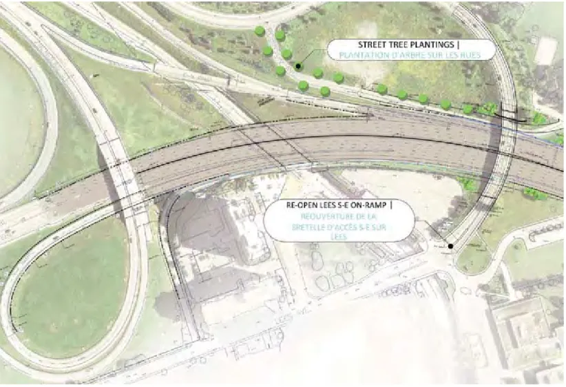
Long term closure of the south‐east ramp at Lees Ave;
Short‐term closure of Lees Avenue Bridge;
Short term closure of the north‐west ramp at Vanier Parkway;
Temporary / night‐time ramp closures;
Temporary road closures to facilitate rapid replacements; and
Transit Priority Measures between Nicholas Street and Blair Road.
During initial stages of this Detail Design project, it was determined that the proposed pier widening at
Hurdman’s Bridge must be completed as a separate advance contract (G.W.P. 4157‐11‐00) in order to minimize
environmental impacts and meet the construction schedule.
Both the 417 expansion project and advance pier widening project are being carried out in accordance with the
HIGHWAY 417 EXPANSION
From Nicholas Street to Ottawa Road 174
G.W.P. 4091‐07‐00, 4320‐06‐00 & 4157‐41‐00
PIC SUMMARY REPORT March 2012
2
Assessment for Provincial Transportation Facilities (MTO, 2000), which has been approved under the Ontario
Environmental Assessment Act. At the conclusion of each Detail Design study, a Design and Construction
Report (DCR) will be prepared and will include:
A description of the recommended plan, including any changes to transportation engineering and
environmental issues identified in Preliminary Design;
A summary of stakeholder consultation; and
A detailed description of anticipated environmental effects and recommended mitigation measures that
will be incorporated into construction documents.
The DCRs will be made available for a 30‐day public review period. Newspaper notices will be published at that
time to explain the review process and identify the locations where the DCR is available for viewing. Upon
completion of the public review period, both projects will be considered to have met the requirements of
MTO’s Class EA.
This report documents the comments and questions received from external agencies and members of the
public during and after the Public Information Centre (PIC) for the Highway 417 expansion project and advance
pier widening project. The PIC was held on Monday, February 13, 2012. This report will become part of the
DCRs prepared for each project.
PURPOSE
Public Information Centres (PIC) provide those people who are most likely to be affected by a proposed project
with the opportunity to review planning and project information and discuss their concerns with members of the
Project Team.
The purpose of this Public Information Centre (PIC) was to provide an opportunity for stakeholders to review and
comment on:
The overall study process;
Existing conditions in the study area;
Plans for the proposed highway expansion;
Construction staging and implementation; and
Anticipated impacts and proposed mitigation.
LOCATION, DATE AND TIME
The PIC was held at the following location and time:
Date/Time: Monday, February 13, 2012
4:00 PM to 8:00 PM, with a presentation at 6:00 PM
Location: Hampton Inn Ottawa Conference Centre
200 Coventry Road
Ottawa, ON K1K 4S3
3
Newspaper Advertisement
On Tuesday, January 24, 2012 an English newspaper notice was published in the Ottawa Citizen and a French
newspaper notice was published in Le Droit to inform stakeholders of the upcoming PIC. At that time, the PIC was
scheduled for Tuesday, February 7, 2012.
The notices were republished on Tuesday, January 31, 2012 and Monday, February 6, 2012 with the revised date
of the PIC (Monday, February 13, 2012). Copies of the newspaper notices are provided in Appendix A.
Direct Mailings
PIC notification letters and copies of the PIC notice were distributed to local elected officials and First Nations
representatives on Friday, January 27, 2012. At this time, the PIC was scheduled for Tuesday, February 7, 2012.
Representatives on these contact lists were subsequently informed of the revised PIC date (Monday, February 13,
2012).
In addition, notification letters and copies of the PIC notice were distributed by mail and email to government
agencies, interest groups, and other stakeholders on the project’s email list on Thursday, February 1, 2012. Copies
of the notification letters are provided in Appendix B.
On‐Site Notification
MRC staff prepared and set up a display board at the Hampton Inn from 3:00 PM to 9:00 PM on Tuesday, February
7, 2012 to advise any interested persons that had not seen the revised notices in the Ottawa Citizen or Le Droit
that the PIC had been rescheduled to a later date. Hampton Inn staff were also informed of the date change, so
that they could respond to inquiries. A copy of the display panel is provided in Appendix C.
PROJECT TEAM REPRESENTATIVES
The following members of the Project Team were available at the PIC to discuss the project with members of the
public:
Mr. David Lindensmith MTO Senior Project Engineer
Mr. Kevin Ogilvie MTO Senior Environmental Planner
Mr. Phil Pawliuk MTO Area Engineer
Mr. Chris Blaney MTO Senior Environmental Planner for Acoustics
Mr. Manny Goetz Consultant Project Manager, MRC / MMM Group
Mr. Steve Regel Consultant Project Engineer, MRC / MMM Group
Mr. Michel Bisson Consultant Project Engineer, MRC / MMM Group (Bilingual)
Mr. Tim Dickinson Consultant Environmental Planner, MRC / MMM Group
Ms. Laura Maxwell Consultant Junior Planner, MRC / MMM Group
HIGHWAY 417 EXPANSION
From Nicholas Street to Ottawa Road 174
G.W.P. 4091‐07‐00, 4320‐06‐00 & 4157‐41‐00
PIC SUMMARY REPORT March 2012
4
FORMAT AND MATERIAL DISPLAYED
This PIC was organized as an informal “drop‐in” style session which allowed interested members of the public to
review, discuss, and provide comments on any aspect of the project. Attendees were greeted upon arrival, were
encouraged to sign the register, and were asked to submit written comments on the comment forms provided.
Bilingual display panels were placed around the room and bilingual representatives from the Project Team were
available to answer questions and discuss the project with attendees. The display boards (provided in Appendix D)
covered the following topics:
Welcome / About this PIC;
Background / Preliminary Design;
Detail Design Study Process;
Scope of Work;
Site Context and Existing Environmental Conditions;
Existing Conditions – Traffic;
Project Timeline;
Recommended Plan – Stage 1 Construction;
Recommended Plan – Stage 2 Construction;
Recommended Plan – Final Conditions;
Rapid Replacement – Lees Avenue Underpass;
Rapid Replacement – Belfast Road Underpass;
Rapid Replacement – Vanier Parkway Underpass;
Summary of Required Lane & Ramp Closures;
Advance Pier Widening at Hurdman’s Bridge;
Environmental Impacts and Mitigation; and
Next Steps.
Shortly after 6 p.m., Mr. David Lindensmith gave a presentation in English that summarized the project and
explained how stakeholders could provide comments. A copy of the presentation is provided in Appendix D.
Directly following the English presentation, Mr. Michel Bisson repeated the presentation in French. The
presentation highlighted key information from the display boards, including:
Project Scope;
Preliminary Design/Environmental Assessment;
Project Benefits;
Construction Timelines; and
Anticipated Ramp and Lane Closures.
Display boards were uploaded to the project website (www.queenswayexpansioneast.com) at approximately 5:00
PM on Monday, February 13, 2012. During the presentation, it was explained that the display boards were posted
on the project’s website for online viewing. The project website address was provided on the last display board.
In addition, a running slideshow was played throughout the evening, highlighting the proposed detour routes and
anticipated traffic disruptions. This presentation was also uploaded to the project website and provided in
5
Transportation Environmental Study Report, Highway 417 (Ottawa Queensway) from Highway 416
Easterly to Anderson Road, Preliminary Design Study and Environmental Assessment, G.W.P. 663‐93‐00
(January 2007)
Preliminary Design Report, Highway 417 (Ottawa Queensway) from Highway 416 Easterly to Anderson
Road, Preliminary Design Study and Environmental Assessment, G.W.P. 663‐93‐00 (January 2007)
Draft Traffic Analysis and Queuing Assessment, Highway 417 Expansion from Nicholas Street to Ottawa
Road 174, Detail Design, G.W.P. 4091‐07‐00 & G.W.P. 4320‐06‐00 (December 2011)
Arborist Report, National Capital Commission Property at Highway 417 Hurdman Bridge, G.W.P. 4091‐07‐
00 & 4320‐06‐00 (Ecoplans, February 2012)
Cultural Heritage Evaluation Reports: Belfast Road Underpass, Lees Avenue Underpass, Rideau River
(Hurdman’s) Bridges, Nicholas Street Underpass, Vanier Parkway Underpass, City of Ottawa, G.W.P. 4091‐
07‐00 & G.W.P. 4320‐06‐00 (Unterman McPhail Associates, July 2011)
Summary of Existing Environmental Conditions Report, Highway 417 Expansion, Operational
Improvements and Infrastructure Rehabilitation. (MMM Group Ltd., September 2011)
Noise Review: Highway 417 Expansion, Operational Improvements and Infrastructure Rehabilitation.
(MRC, February 2012)
PIC attendees had the opportunity to ask the Project Team questions and were encouraged to provide written
comments on the comment sheets provided. The questions and responses are detailed in Table 1 below.
ATTENDANCE
During the course of the advance agency session (3:00 PM – 4:00 PM) and the public information centre (4:00 PM
– 8:00 PM), a total of ninety‐one (91) individuals signed the register.
Attendees included:
One (1) MP representative;
One (1) MPP representative;
Five (5) Councillors and their staff;
City of Ottawa staff;
Representatives from utility companies;
Representatives from local Community Associations; and
General members of the public.
HIGHWAY 417 EXPANSION
From Nicholas Street to Ottawa Road 174
G.W.P. 4091‐07‐00, 4320‐06‐00 & 4157‐41‐00
PIC SUMMARY REPORT March 2012
6
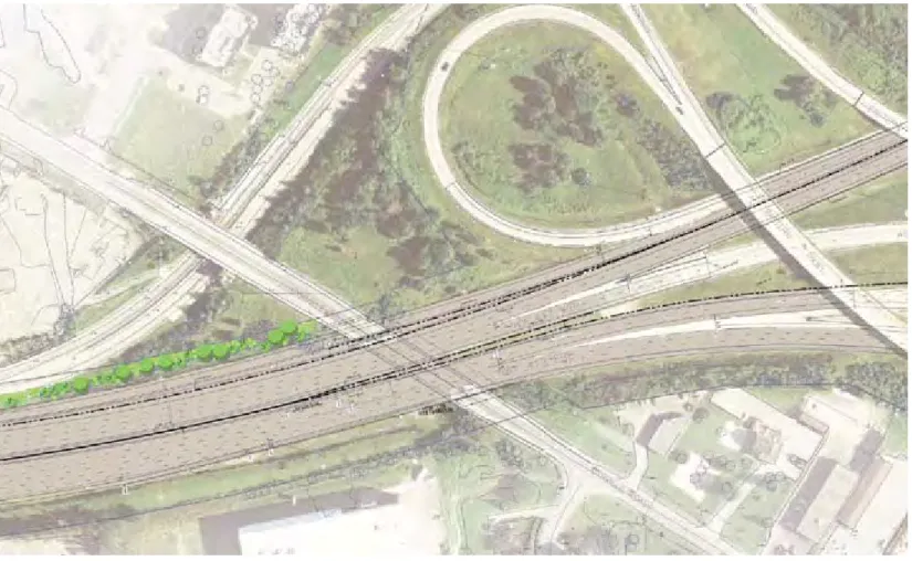
Public Information Centre Photos (Monday, February 13, 2012)
WEBSITE
As noted above, a website for the Highway 417 Expansion Project (GWP 4091‐07‐00 & GWP 4320‐06‐00) was
created to provide project information, updates and documents to interested stakeholders. The project website is
www.queenswayexpansioneast.com.
During the two week period following the PIC (February 13th – 27th inclusive), the website had 1,767 visits. Since
the inception of the Detail Design project, over 2,000 unique visitors have accessed the site.
7
PIC attendees were encouraged to complete comment sheets. Twenty‐four (24) comment sheets were submitted
at the PIC, of which fifteen (15) required a response. The nine (9) comment sheets where a response was not
required detailed support for the project in general, appreciation of the consultation process and information
available, and concern over linkages to the future interprovincial bridge.
MTO received five (5) letters in response to the PIC notification letters sent to external government agencies, local
elected officials, First Nations representatives, and other stakeholders. The comments and questions received
were from:
Conseil des écoles catholiques du Centre‐Est;
Ottawa Catholic School Board;
Ministry of Aboriginal Affairs, Consultation Office;
Transport Canada, Ontario Region; and
Alderville First Nation.
An additional twenty‐eight (28) comments were received through email, the project website, by letter, or by
phone, most of which required a response.
Table 1 contains a summary of the comments received through comment sheets, letters, phone calls, and email, in
no specific order. Completed comment sheets, letters, and emails are available for review in Appendix D.
The table also includes a summary of how the comments were addressed. All comments requiring a response will
be responded to with a letter or email addressing the submitter’s comments, questions and/or concerns.
Please Note: Comment Sheets (CS) and other correspondence received (CR) have been given a reference number
(top right corner) and are included in Appendix D. Personal information has been removed in accordance with the
HIGHWAY 417 EXPANSION
From Nicholas Street to Ottawa Road 174
G.W.P. 4091‐07‐00, 4320‐06‐00 & 4157‐41‐00
PIC SUMMARY REPORT March 2012 8 TABLE 1:
SUMMARY OF COMMENTS RECEIVED AND RESPONSES
Sheet
Ref. No
Response
Required?
Summary of Comment Summary of How the Comment Was Addressed
CR.1 Y Inquired whether the presentation will be made in English and French or if there will be simultaneous translation
available.
A response was sent explaining that a brief presentation would be given in English and French, and that the display material would be
bilingual. It was also explained that there would be bilingual staff available to answer questions at the PIC.
CR.2 Y Concerned over the elimination of the movement from Highway 417 westbound to the St. Laurent off‐ramp. The highway expansion project currently being designed from Nicholas Street to Ottawa Road 174 was recommended as the result of a
Preliminary Design and Environmental Assessment study for Highway 417 from Highway 416 to Anderson Road, which received
environmental clearance in 2008. The study examined needs and opportunities with respect to mobility, operations and safety and
arrived at a recommended alternative for highway modifications to address the issues identified. The purpose of this Detail Design
undertaking is to design the approved Environmental Assessment for implementation.
During the EA study, traffic operations were assessed throughout the study area, including at the Hwy 417/ Ottawa Road 174 “Split”. It
was determined that one contributing factor to problems in the area was the movement of westbound Highway 417 vehicles across all
lanes of 417 to access the off‐ramp to St. Laurent over a relatively short distance. This movement causes disruptions to the smooth flow
of traffic and is also a safety concern.
A number of alternatives were examined to improve operations at this location. The study recommendations included the elimination of
the movement from Highway 417 westbound to St. Laurent Boulevard. This off‐ramp will continue to be accessible from Ottawa Road
174 westbound. The future configuration will resemble Hwy 417 westbound in the vicinity of Highway 416 and Moodie Drive, where
access to Moodie Drive is precluded from Hwy 416 but access continues to be provided from Highway 417.
The traffic analysis undertaken during the EA study showed that approximately 2/3 of the traffic using this off‐ramp today originated
from Ottawa Road 174 westbound.
For traffic originating from Hwy 417 to the east of the split, alternate routes to St. Laurent Blvd north of Hwy 417 include Innes Road or
the Aviation Parkway and Ogilvie Road. It is not expected that a significant number of westbound vehicles will exit at the Vanier Parkway
and backtrack to St. Laurent Boulevard.
CR.3 Y Concerned regarding how this project is being integrated with the Interprovincial Crossing project and the
possibility of a new 8‐lane bridge eventually being built as a northward extension/widening of the Aviation
Parkway.
The highway expansion project currently being designed from Nicholas Street to Ottawa Road 174 was recommended as the result of a
Preliminary Design and Environmental Assessment study for Highway 417 from Highway 416 to Anderson Road, which received
environmental clearance in 2008. The study examined needs and opportunities with respect to mobility, operations and safety and
arrived at a recommended alternative for highway modifications to address the issues identified.
Alternatives were considered taking into account not only their effectiveness in satisfying identified needs, but also on the impacts of
implementation and opportunities to mitigate impacts.
The Ministry’s study received environmental clearance to proceed to construction in 2008. Since that time, the NCC has initiated an
Environmental Assessment study for potential Interprovincial Bridge Crossing(s). The ministry is a member of the study team, a funding
partner of the Interprovincial Bridge Crossing Study (along with MTQ) and participates on the study steering committee. The NCC has
been aware of the Ministry’s Highway 417 EA from the outset of the Interprovincial Bridge study and is taking into account the
Ministry’s approved future configuration of Highway 417.
It is the responsibility of the NCC, as part of the Interprovincial Bridge EA, to assess and mitigate impacts of that undertaking, including
the adjacent transportation network.
Comments about how the implementation of a new Interprovincial Bridge crossing may affect Highway 417 should be expressed at the
upcoming public meetings for the Interprovincial Crossing EA.
CR.4 Y Requested information regarding where and when the Open House is scheduled. A response was sent advising that the date for the PIC was Monday, February 13, 2012 and that the location was the Hampton Inn
Conference Centre. A copy of the published newspaper notice was attached.
CR.5 Y Concerned that the PIC notification was sent in error. The individual’s email address was identified on the contact list for the Preliminary Design and Environmental Assessment study from
Highway 416 to Anderson Rd, which received environmental clearance in 2008. Since this Detail Design project follows from the parent
9 Sheet Ref. No Response Required?
Summary of Comment Summary of How the Comment Was Addressed
CR.6 Y Concerned over closure of southeast ramp at Lees Avenue and inquired whether closure is permanent. It is anticipated that the south to east ramp (from Lees Avenue to Highway 417 eastbound) will need to be closed to all traffic for the
duration of construction (Stage 1 & Stage 2 construction). The anticipated closure would occur between Fall 2012 and Fall 2015.
The closure is necessary because there is insufficient space to terminate lanes from the north to east ramp (from Nicholas to Highway
417 eastbound) AND the south to east ramp in a safe manner. In other terms, if the south to east ramp were to remain open during
construction, it would result in unsafe conditions.
CR.7 Y Requested information regarding the location of staging areas for the rapid replacement of bridge structures. A response will be sent highlighting the planned staging areas for the planned Lees Avenue, Belfast Road, and Vanier Parkway rapid
bridge replacements. A map will be provided to clarify the staging locations, and the project website address was also given.
CR.8. N Requested a change in contact information for project correspondence to the Ottawa Catholic School Board. The contact for the Ottawa Catholic School Board was updated as requested.
CR.9 Y Expressed concern regarding the design of the intersection of the Aviation Parkway and highway 417 to
accommodate future public transportation needs. Suggested intersection should be designed as ‘clover leaf’.
Expressed concern that access to Rockcliffe Airport must be maintained as Ottawa will require two airports in
the future.
The highway expansion project currently being designed from Nicholas Street to Ottawa Road 174 was recommended as the result of a
Preliminary Design and Environmental Assessment study for Highway 417 from Highway 416 to Anderson Road, which received
environmental clearance in 2008. The study examined needs and opportunities with respect to mobility, operations and safety and
arrived at a recommended alternative for highway modifications to address the issues identified. At the time of the Preliminary Design
and Environmental Assessment, a new ramp at the location of the Aviation Parkway was not considered necessary to address traffic
diversion, and as such, the current Detail Design project does not involve any major modifications to accesses to or from Aviation
Parkway. The purpose of this Detail Design undertaking is to design the approved Environmental Assessment for implementation.
CR.10 N Requested to be added to contact list. The individual was added to the project email contact list, and will receive notification regarding the submission of the Design and
Construction report for the 30‐day public review period.
CR.11 Y Expressed support for closing the exit onto St. Laurent for traffic from Orleans. Suggested that a new off‐ramp
should be accommodated at Aviation Parkway, as opposed to the detour to Innes Road.
The highway expansion project currently being designed from Nicholas Street to Ottawa Road 174 was recommended as the result of a
Preliminary Design and Environmental Assessment study for Highway 417 from Highway 416 to Anderson Road, which received
environmental clearance in 2008. The study examined needs and opportunities with respect to mobility, operations and safety and
arrived at a recommended alternative for highway modifications to address the issues identified. Traffic modelling completed at the
time of the Preliminary Design and Environmental Assessment indicated that a new ramp at the location of the Aviation Parkway was
not considered necessary to address traffic diversion. The purpose of this Detail Design undertaking is to design the approved
Environmental Assessment for implementation.
The movement from Highway 417 westbound to the St. Laurent off‐ramp will be eliminated, while the off‐ramp will continue to be
accessible from Ottawa Road 174 westbound.
During the EA study, traffic operations were assessed throughout the study area, including at the Hwy 417/ Ottawa Road 174 “Split”. It
was determined that one contributing factor to problems in the area was the movement of westbound Highway 417 vehicles across all
lanes of 417 to access the off‐ramp to St. Laurent over a relatively short distance. This movement causes disruptions to the smooth flow
of traffic and is also a safety concern.
A number of alternatives were examined to improve operations at this location. The study recommendations included the elimination of
the movement from Highway 417 westbound to St. Laurent Boulevard. The future configuration will resemble Hwy 417 westbound in
the vicinity of Highway 416 and Moodie Drive, where access to Moodie Drive is precluded from Hwy 416 but access continues to be
provided from Highway 417.
The traffic analysis undertaken during the EA study showed that approximately 2/3 of the traffic using this off‐ramp today originated
from Ottawa Road 174 westbound.
For traffic originating from Hwy 417 to the east of the split, alternate routes to St. Laurent Blvd north of Hwy 417 include Innes Road or
the Aviation Parkway and Ogilvie Road.
HIGHWAY 417 EXPANSION
From Nicholas Street to Ottawa Road 174
G.W.P. 4091‐07‐00, 4320‐06‐00 & 4157‐41‐00
PIC SUMMARY REPORT March 2012
10
TABLE 1:
SUMMARY OF COMMENTS RECEIVED AND RESPONSES
Sheet
Ref. No
Response
Required?
Summary of Comment Summary of How the Comment Was Addressed
CR.13 Y Concerned regarding the long term closure of the S‐E Lees Avenue on‐ramp including:
1) Length of closure
2) Results of traffic studies completed to understand the local traffic generated by closing the eastbound on‐
ramp at Lees avenue including: how many cars currently access this on‐ramp on weekdays and weekends
and where is this traffic going to go when the on‐ramp is closed.
3) The plan for people to access the eastbound Queensway when the on‐ramp is closed for the long‐term. What
mitigation plans are going to be put in place to minimize impact to the community?
4) Were alternatives to long term closure investigated, and if so, why were they dismissed? Was an alternative
to create a temporary on ramp that joins in with the southward on‐ramp from Nicholas Street?
5) Is there a plan to properly direct traffic from the closed on‐ramp to the next closest on‐ramp, and if so, will
traffic light timing be adjusted to ensure smooth traffic flow? How will increased traffic over Pretoria Bridge
be handled?
Requested for more detailed information about the project in addition to what is presented on the project
website.
< Please refer to response provided for CR.6 >
No alternatives were identified that would provide safe access from Lees Avenue to Highway 417 eastbound during construction.
Existing traffic conditions are as follows: AM Peak Hour – 300 cars; PM Peak Hour – 550 cars; Saturday Peak Hour – 500 cars; and
Average Daily Traffic (ADT) ‐ 5800 cars per day.
The assumed redistribution of the Lees on‐ramp traffic was based on City’s TRANS model (2005) for trip patterns, which is based on
survey information about resident’s origins and destinations. The following redistribution was assumed:
10% Metcalfe EB on‐ramp
10% Nicholas EB on‐ramp
35% Vanier EB on‐ramp via Montreal Road and Main Street/Riverside Drive
15% Main/Smyth to neighbourhood and further east to Innes Road
30% Montreal Road to communities N‐E and further east
The City is aware of project timing and can schedule any local road closures to minimize impacts. The City of Ottawa has live‐monitoring
of the key intersections within the study area, and adjusts signal timings to accommodate new traffic and to improve efficiencies.
However, as there are limited opportunities to cross the Rideau River, where the corridors identified already experience congestion, the
ramp closure will put more pressure on these roadways. Delays can be expected.
The individual was added to the project email contact list, and will receive notification regarding the submission of the Design and
Construction report for the 30‐day public review period. The DCR contains detailed project information.
CR.14 Y Ministry of Aboriginal Affairs requested a list of Aboriginal Communities that had been contacted as part of this
Environmental Assessment.
The following Aboriginal Communities are on the project contact list: – Algonquins of Pikwakanagan
– Algonquins of First Nation Consultation Office c/o Jp2g – Ottawa Algonquin First Nation
– Chippewas of Georgina Island
– Mississaugas of the New Credit First Nation – Mississaugas of Scugog Island First Nation – Beausoleil First Nation
– Alderville First Nation – Hiawatha First Nation – Curve Lake First Nation – Moose Deer Point First Nation – Ottawa Metis Council
CR.15 Y Concerned over the elimination of the movement from Highway 417 westbound to the St. Laurent off‐ramp.
Inquired what the recommended route to St. Laurent Centre would be for vehicles commuting from the east
end via the 417.
< Please refer to response provided for CR.2 >
CR.16 Y Asked if entrance to the Queensway west will be prevented by the expansion, is there any plan to give access to
the Queensway west via the Aviation parkway?
Clarification of the question will be requested after which a response will be sent accordingly.
CR.17 N Requested that contact information be updated for the Director of Education for the Conseil des écoles
catholiques du Centre‐Est.
The contact for the Conseil des écoles catholiques du Centre‐Est was updated.
CR.19 N Requested to be included on the contact list for this project. This contact was added to the project contact list and will receive a letter regarding the submission of the Design and Construction
report for the 30‐day public review period.
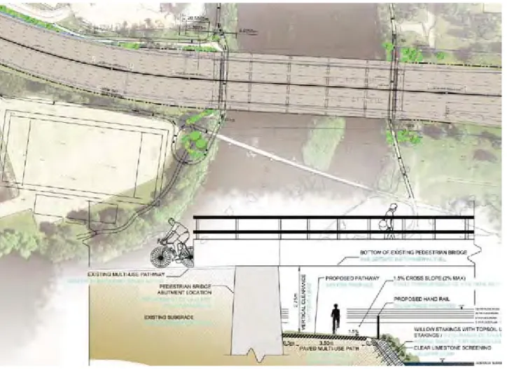
CR.20 Y Concerned regarding closure of the recreational pathways along the Rideau River during construction as the
alternative crossings of the Queensway are at Lees Ave. and Riverside Dr. are not designed or maintained to
support increased foot and cycle traffic and do not provide a direct connection.
The pathway on the east side of the river will remain open for the duration of the advance pier widening project.
Between July and September 2012, traffic management measures including advance signing and flagging will be provided to ensure the
11 Sheet Ref. No Response Required?
Summary of Comment Summary of How the Comment Was Addressed
of Highway 417). After September 2012, access from the east side of the Rideau River will no longer be required.
On September 4, 2012, the City of Ottawa multi‐use pathway on the west side of the river will be closed and will remain closed until
May 2013, as construction access will be provided from the west side of the Rideau River (both north and south of Highway 417)
commencing September 4, 2012. Opportunities to keep this pathway open were explored during the Detail Design. However, due to the
existing horizontal and vertical alignment of the pathway, adequate visibility cannot be provided and the pathway must be closed to
ensure safety of multi‐use pathway users.
To mitigate impacts to pathway users, the required closure of the City of Ottawa pathway on the west side of the Rideau River will be
timed to avoid the busy summer months including the Victoria Day (May 24 – 27) and Labor Day (September 1‐3) long weekends.
Advance signage will also be provided two weeks prior to notify pathway users of the upcoming closure. During this closure, alternate
access across Highway 417 is available via Robinson Avenue and Lees Avenue, and will be signed as a detour route.
By May 2013, both pathways will be re‐opened and will remain open.
CR.21 N Transport Canada requested that correspondence on this project be changed to be addressed to the
Environmental Assessment Coordinator.
Attached an updated Navigable Waters Protection Act Application Guide and Form, which the proponent should
prepare and submit for the approval of work(s) over the Rideau Canal. Any questions about the NWPA
application process should be directed to the Navigable Waters Protection Program at 1‐866‐821‐6631 or
NWPontario‐[email protected].
Suggested that Inquiries regarding the Railway Safety Act can be directed to Dwayne Williams, Manager of
Engineering, at (416) 973‐2326 or [email protected].
The contact list was updated, and notification will be sent identifying the submission of the Design and Construction report for the 30‐
day public review period.
An application under NWPA was submitted to Transport Canada in December 2011.
CR.22 Y Concerned that the Queensway Expansion project will cause there to be more speeding vehicles on Blair Road
when traffic is diverted.
Suggested that the City install permanent stop‐signs along Blair Road (between Ogilvie and Montreal Road) to
help slow traffic to the correct speed.
Suggested that increased policing of the street would reduce incidents of speeding. Offered driveway for police
cars to set up a speed trap.
The Project Team is working with City of Ottawa representatives throughout the project and concerns about traffic on local roads will be
forwarded to the appropriate City of Ottawa staff, for consideration.
CR.23 Y Inquired about comments received that might influence the design of the Aviation Parkway / Ottawa Road 174
interchange.
The highway expansion project currently being designed from Nicholas Street to Ottawa Road 174 was recommended as the result of a
Preliminary Design and Environmental Assessment study for Highway 417 from Highway 416 to Anderson Road, which received
environmental clearance in 2008.
The purpose of the Detail Design is to prepare this plan for implementation.
CR.24 Y Inquired about design of replacement bridges and improvements for cyclists and pedestrians (including,
widening sidewalks, and additional separations between sidewalks and travel lanes).
Inquired about Riverside Drive/Vanier Parkway overpass and why it is not planned to be widened. Particularly in
the northbound direction, the increasing volumes of vehicles wishing to cross the overpass in order to reach the
westbound on‐ramp to Highway 417 are forced to merge from 3 lanes down to 2 lanes causing queues to form
back towards the intersection with Tremblay Road. This opportunity should be used to also add, at minimum, a
3rd NB lane to access the WB on‐ramp. It is also noted that the original EA on page 60 makes no reference at all
to widening St. Laurent bridge and it does make reference to carry‐forward the option to widen to 6 lanes the
Riverside Drive / Vanier Pkwy overpass.
Concerned over impacts to queues on Nicholas Street. The increased carrying capacity/volume of the 417 on
downtown off‐ramps, particularly on Nicholas Ave NB. Currently the AM peak hour volumes of NB traffic on
Nicholas Street making a WB left turn onto Laurier Avenue have reached the carrying capacity. As a result, traffic
queues begin to form southwards on Nicholas.
The highway expansion project currently being designed from Nicholas Street to Ottawa Road 174 was recommended as the result of a
Preliminary Design and Environmental Assessment study for Highway 417 from Highway 416 to Anderson Road, which received
environmental clearance in 2008. The study examined needs and opportunities with respect to mobility, operations and safety and
arrived at a recommended alternative for highway modifications to address the issues identified. The purpose of this Detail Design
undertaking is to design the approved Environmental Assessment for implementation.
The proposed road, bridge, and sidewalk modifications included in this project have been designed to meet the City of Ottawa’s design
standards.
The St. Laurent bridge is being rehabilitated. Although the bridges will be widened to accommodate the Highway 417 expansion, there
are no additional lanes planned for St. Laurent Boulevard itself.
Decisions regarding lane provisions for the Lees Avenue, Vanier Parkway, and Belfast bridges reflect the City of Ottawa’s plans for the
overall road network.
The Nicholas off‐ramp is not being expanded, so the traffic volumes from the ramp destined to the Laurier/Nicholas intersection would
not increase significantly. The ramp’s capacity is not changing, so operations can be expected to remain similar to existing conditions.
HIGHWAY 417 EXPANSION
From Nicholas Street to Ottawa Road 174
G.W.P. 4091‐07‐00, 4320‐06‐00 & 4157‐41‐00
PIC SUMMARY REPORT March 2012
12
TABLE 1:
SUMMARY OF COMMENTS RECEIVED AND RESPONSES
Sheet
Ref. No
Response
Required?
Summary of Comment Summary of How the Comment Was Addressed
Concerned regarding Belfast being reinstated to only 2‐lanes given current and planned development. The
bridge should be constructed to accommodate 4 lanes of traffic on Belfast Road.
Concerned that the closure of the St‐Laurent S‐E ramp to general traffic will add additional traffic on Tremblay
Road westbound to access the Vanier Parkway S‐E ramp.
Concerned regarding the lack of coordination of this project with other planned projects including OLRT and the
development at the Train Yards/PWGSC lands on Tremblay.
Disappointed on the lack of representation from the City of Ottawa and City Councillors.
Preliminary Design and Environmental Assessment study for Highway 417 from Highway 416 to Anderson Road, which received
environmental clearance in 2008. The study examined needs and opportunities with respect to mobility, operations and safety and
arrived at a recommended alternative for highway modifications to address the issues identified. The purpose of this Detail Design
undertaking is to design the approved Environmental Assessment for implementation.
The St. Laurent northbound to 417 eastbound on‐ramp would be closed to general traffic starting Spring 2013, to help address safety
concerns with the weave from the on‐ramp to OR 174 over a short distance.
Five (5) City Councillors attended the PIC, and other City staff and representatives from the Councillors’ offices also attended.
CR.26 Y Concerns included the following:
If Nicholas is extended across the Rideau River in the future, the two‐lane ramp onto the east‐bound 417 might
interfere.
The lane division at the E‐N off‐ramp to Nicholas might be simpler as a straight 2 and 3 split.
The pedestrian walkway along the Central Transitway, between Lees and Campus Stations, must be maintained
during construction.
People living around the Mann/Robinson/Lees area will have long detours for three years during the
construction.
Lees Avenue should have complete sidewalks on both sides of the road.
It should be verified that articulated buses will be able to negotiate the steeper, curved approaches to the Lees
Bridge.
The N‐E on‐ramp from the Vanier Parkway should continue as the auxiliary lane, with the S‐E on‐ramp from
Riverside merging; similar to the plan for the south side of the Pinecrest/417 interchange.
The Belfast Bridge should be widened and lengthened as it will be a bottle‐neck in both directions.
Buses merging from the St. Laurent Station onto the N‐W on‐ramp from St. Laurent Boulevard should do so at
the beginning of the acceleration lane, not half‐way along it.
Slow accelerating buses should not be allowed to use the S‐E on‐ramp from St. Laurent Boulevard, crossing three
417 lanes to get to the OR174.
St. Laurent Boulevard becomes even less pedestrian friendly and there is no improvement in pedestrian access
to St. Laurent Station from the road.
If the future Inter‐Provincial Bridge is attached to the Aviation Parkway, access to St. Laurent Boulevard from the
east will become more difficult.
The west‐bound OR 174 will be reduced to a single lane for 8‐10 months; through‐which buses will need to
travel.
Until the Cyrville Bridge is replaced again, the west‐bound traffic will be limited to two lanes from the OR174
and two lanes from the 417.
The highway expansion project currently being designed from Nicholas Street to Ottawa Road 174 was recommended as the result of a
Preliminary Design and Environmental Assessment study for Highway 417 from Highway 416 to Anderson Road, which received
environmental clearance in 2008.
The purpose of the Detail Design is to prepare this plan for implementation. At this time, an extension of Nicholas is not considered
within the scope of this project.
The ultimate arrangement in the vicinity of the E‐N ramp at Nicholas is being designed with four Highway 417 westbound lanes, and a
two‐lane off‐ramp. The left lane of the Nicholas off‐ramp will be an ‘either/or’ lane. This arrangement allows for a consistent four lane
cross section along the corridor, as approved in 2008.
During the planned construction activities on the Central Transitway bridge, pedestrian traffic may need to be detoured off the existing
sidewalk. However, it is proposed that a minimum of one sidewalk be maintained under the structure at all times (except for
intermittent temporary conditions, such as during the installation of roadway protection). The proposed construction staging plan for
the Central Transitway bridge is subject to further discussion with the City of Ottawa.
The Lees Avenue bridge design includes a sidewalk on the east side of the bridge that will extend northerly to tie into the existing
sidewalk. The Lees Avenue bridge design also includes a sidewalk on the west side (over the bridge), which will tie into the reinstated
asphalt boulevard on the west side of Lees Ave.
The proposed road, bridge, and sidewalk modifications included in this project have been designed to meet the City of Ottawa’s design
standard, including transit service operations.
The approved Preliminary Design and Environmental Assessment involved widening Highway 417 to four lanes in each direction. In the
section identified from Vanier Parkway to St. Laurent, there is insufficient property to include the N‐E on‐ramp from the Vanier Parkway
as an auxiliary lane.
Decisions regarding lane provisions on local streets, such as Belfast Road, reflect the City of Ottawa’s plans for the overall road network. Buses merging from the St. Laurent Station onto the N‐W on‐ramp from St. Laurent Boulevard cannot enter the ramp at the start of the
acceleration lane because of the grade differential at that location.
The S‐E on‐ramp at St. Laurent Boulevard will be permanently closed to general traffic as of Spring 2013. In the future, the S‐E ramp will
be open for emergency services and deadheading buses only, as per the approved Preliminary Design. The use of the S‐E ramp by off‐
service buses will be limited to off‐peak periods and was deemed necessary to support the City’s transit objectives.
The Detail Design is not changing pedestrian access to and from St. Laurent Transit Station.
It is within the scope of the Interprovincial Bridge EA to assess and mitigate impacts of that undertaking, including the adjacent
transportation network. Comments about how the implementation of a new Interprovincial Bridge crossing may affect Highway 417
should be expressed at the upcoming public meetings for the Interprovincial Crossing EA.
The approved Preliminary Design incorporates 2 lanes from Highway 417 and 2 lanes from OR 174 westbound through ‘the Split’.
Construction staging necessitates lane closures on OR 174, as shown on the Display Materials at the PIC.
CR.27 Y Concerned regarding whether the project still involved the closure of the St. Laurent northbound to 417
eastbound on‐ramp to general traffic and whether the ramp would be for emergency and transit access only. If
yes, requested the rationale for this change.
Asked to be added to the official contact list to be notified when the DCR is available for public review.
The St. Laurent northbound to 417 eastbound on‐ramp will be closed to general traffic beginning Spring 2013. In the future, after
construction, the ramp will be open to EMS and off‐service buses only, as per the approved Preliminary Design and Environmental
Assessment. The ramp is closed to general traffic to help address safety concerns with the weave from the on‐ramp to OR 174 over a
short distance.
13 Sheet Ref. No Response Required?
Summary of Comment Summary of How the Comment Was Addressed
CR.28 Y Asked when to expect to receive a response regarding questions on the Queensway widening project.
Concerned over closure of the eastbound on‐ramp at Lees Avenue for a period of 3 years. Concerned with the
impact of this closure on the community of Old Ottawa East, especially given that the alternate on‐ramps
are either not in close proximity to that on‐ramp (i.e. Nicholas / Riverside drive on‐ramps) or involve routes that
are already significant traffic bottlenecks subject to periodic closure (e.g., Pretoria Bridge).
Suggested that future public consultations of this nature should include some kind of acknowledgement email: i)
confirming receipt of the input, ii) indicating that there is a two week period for comments and iii) the time
frame to expect a response (if applicable).
The two week comment period ended on February 27, 2012. Individual responses are being compiled.
The suggested improvements to the consultation process were noted and included in the Design and Construction Report (DCR).
< Please refer to response provided for CR.6 >
The assumed redistribution of the Lees on‐ramp traffic was based on City’s TRANS model (2005) for trip patterns, which is based on
survey information about resident’s origins and destinations. The following redistribution was assumed:
10% Metcalfe EB on‐ramp
10% Nicholas EB on‐ramp
35% Vanier EB on‐ramp via Montreal Road and Main Street/Riverside Drive
15% Main/Smyth to neighbourhood and further east to Innes Road
30% Montreal Road to communities N‐E and further east
The City is aware of project timing and can schedule any local road closures to minimize impacts.
As there are limited opportunities to cross the Rideau River, where the corridors identified already experience congestion, the ramp
closure will put more pressure on these roadways and delays can be expected.
CR.29 Y Expressed thanks regarding the consultation request to Alderville First Nation regarding the project, which is
being proposed within our Traditional and Treaty Territory.
Expressed appreciation for the fact that the Ministry of Transportation recognizes the importance of First
Nations Consultation and that your office is conforming to the requirements within the Duty to Consult Process.
Asked that Alderville be kept apprised of any archaeological findings, burial sites or any environmental impacts,
should any occur.
Explained that although Alderville FN may not always have representation at all stakeholders meetings, it is our
wish to be kept apprised throughout all phases of this project via mail or email.
The contract documents will include standard environmental mitigation measures for projects of this type, which will be documented in
the Design and Construction Report.
The contact will be informed of the filing of the DCR for the 30‐day public review period.
CR.30 N Concerned regarding the provision of lighting at Hurdman’s Bridge for the pathway on either side of the Rideau
River. Suggested that vandal‐proof lighting be installed.
Concerned regarding protecting pedestrians from being splashed or sprayed by vehicle traffic on Lees, Vanier
and Belfast overpasses. Suggested the sidewalks should be wider and/or buffered by a cycle lane.
Suggested the design of the overpass abutments, sound attenuation fencing, lighting, etc. should be designed to
a high standard to make the Nation’s Capital look nice to visitors and residents.
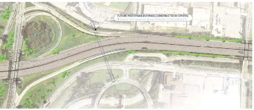
Explained that there is a need to create a safe pedestrian crossing to the St. Laurent Transit station and correct
the unsafe pedestrian crossing that occurs on the north side of Highway 417 on the west side of St. Laurent
Boulevard where pedestrians cross the westbound on‐ramp and the westbound bus entry ramp to the upper
level of the St. Laurent Transitway station. Suggested MTO work with the City of Ottawa to implement a new
pathway/bridge connection parallel to the on‐ramp that allows east side access to the station.
The comments were noted and included in the Design and Construction Report (DCR).
The individual was added to the project email contact list.
Specific comments/suggestions have been forwarded to the City of Ottawa for review/discussion.
CR.31 Y Explained that the construction impacts on existing cycling / pedestrian routes should be minimized. Specifically,
it appears as though the pathways under the Queensway bridge (both on the east and the west side of the
Rideau River) will be kept open only in the summer. These pathways are essential through the entire year so
that thousands of people can get past the Queensway without having to make lengthy and unsafe detours to the
Vanier Parkway or to the Lees bridge.
Expressed support for the temporary routing of the "through 200 Lees / uOttawa property" pathway along the
river (i.e. from the Queensway bridge then southwest past the area of the proposed stadium/field). Also offered
strong support of the conversion of this temporary routing into a permanent pathway, as per "Final Stage"
drawings.
Explained that the lengthy closure of the on‐ramp of Lees Avenue has the potential to cause both considerable
inconvenience and additional congestion for residents of Old Ottawa East. In terms of inconvenience, residents
The pathway on the east side of the river will remain open for the duration of the advance pier widening project.
Between July and September 2012, traffic management measures including advance signing and flagging will be provided to ensure the
safe passage of construction equipment across the NCC recreational pathway on the east side of the Rideau River (both north and south
of Highway 417). After September 2012, access from the east side of the Rideau River will no longer be required.
On September 4, 2012, the City of Ottawa multi‐use pathway on the west side of the river will be closed and will remain closed until
May 2013, as construction access will be provided from the west side of the Rideau River (both north and south of Highway 417)
commencing September 4, 2012. Opportunities to keep this pathway open were explored during the Detail Design. However, due to the
existing horizontal and vertical alignment of the pathway, adequate visibility cannot be provided and the pathway must be closed to
ensure safety of multi‐use pathway users.
To mitigate impacts to pathway users, the required closure of the City of Ottawa pathway on the west side of the Rideau River will be
HIGHWAY 417 EXPANSION
From Nicholas Street to Ottawa Road 174
G.W.P. 4091‐07‐00, 4320‐06‐00 & 4157‐41‐00
PIC SUMMARY REPORT March 2012
14
TABLE 1:
SUMMARY OF COMMENTS RECEIVED AND RESPONSES
Sheet
Ref. No
Response
Required?
Summary of Comment Summary of How the Comment Was Addressed
will not be able to access the eastbound Queensway except by going to the Metcalfe or Vanier Parkway on‐
ramps. What is more serious is that other motorists may be detouring through Ottawa East, causing congestion
on Lees, Main, and Hawthorne. These residential routes are already very busy and the potential of additional
traffic may result in gridlock, particularly around Pretoria Bridge. We ask you to assess the impacts on Old
Ottawa East as a result of the closure of the on‐ramp at Lees and for you to discuss with the Ottawa East
community proposed mitigation measures to minimize the impact of the resulting additional traffic in the
community.
One possible impact of Queensway widening should be the additional capacity across the Rideau River
screenline. We are interested in knowing what additional volumes will be accommodated by virtue of the
expansion. Also, if there are available multi‐year volume counts of traffic going on and coming off the
Queensway at Lees, Nicholas and Riverside Drive / Alta Vista Drive we would appreciate knowing where we
could access such data.
Advance signage will also be provided two weeks prior to notify pathway users of the upcoming closure. During this closure, alternate
access across Highway 417 is available via Robinson Avenue and Lees Avenue, and will be signed as a detour route.
By May 2013, it is expected that the pathway will re‐open and will remain open for the duration of construction.
< Please refer to response provided for CR.6 >
The assumed redistribution of the Lees on‐ramp traffic was based on City’s TRANS model (2005) for trip patterns, which is based on
survey information about resident’s origins and destinations. The following redistribution was assumed:
10% Metcalfe EB on‐ramp
10% Nicholas EB on‐ramp
35% Vanier EB on‐ramp via Montreal Road and Main Street/Riverside Drive
15% Main/Smyth to neighbourhood and further east to Innes Road
30% Montreal Road to communities N‐E and further east
The City is aware of project timing and can schedule any local road closures to minimize impacts.
As there are limited opportunities to cross the Rideau River, where the corridors identified already experience congestion, the ramp
closure will put more pressure on these roadways and delays can be expected.
CR.32 Y Expressed support for the project.
Expressed concern over the following:
1. Conversion of the St Laurent Blvd on‐ramp to transit and emergency vehicle only use
2. Realignment of the St. Laurent Blvd. off‐ramp to prevent movement from the 417 westbound to
St. Laurent Blvd.
3. Long term closure of the south‐east ramp at Lees Ave.
The St. Laurent northbound to 417 eastbound on‐ramp will be closed to general traffic starting Spring 2013, to help address safety
concerns with the weave from the on‐ramp to OR 174 over a short distance.
< Please refer to response provided for CR.2 >
< Please refer to response provided for CR.6 >
CR.33 Y Expressed strong concern over the closure of access to the St. Laurent off‐ramp from Highway 417 westbound. < Please refer to response provided for CR.2 >
CS.1 N Offered support of changes to the northbound exit from Hwy 174 onto St. Laurent north
Offered support of improvements to the Bronson eastbound exit
Asked that all existing noise barriers should be maintained or improved
The comments were noted and included in the Design and Construction Report (DCR).The individual was added to the project email
contact list.
CS.2 Y
Concerned that the Riverside Drive/Vanier Parkway overpass should be widened with the outer lanes dedicated
for Highway 417 access.
The highway expansion project currently being designed from Nicholas Street to Ottawa Road 174 was recommended as the result of a
Preliminary Design and Environmental Assessment study for Highway 417 from Highway 416 to Anderson Road, which received
environmental clearance in 2008. The study examined needs and opportunities with respect to mobility, operations and safety and
arrived at a recommended alternative for highway modifications to address the issues identified. The purpose of this Detail Design
undertaking is to design the approved Environmental Assessment for implementation.
The proposed road, bridge, and sidewalk modifications included in this project have been designed to meet the City of Ottawa’s design
standards.
Decisions regarding lane provisions for the Lees Avenue, Vanier Parkway, and Belfast bridges reflect the City of Ottawa’s plans for the
overall road network.
This comment will be forwarded to the appropriate City of Ottawa staff, for consideration.
CS.3 Y
Concerned regarding closure of Lees Avenue bridge. Must maintain access for pedestrians on the OC Transpo
walkway beside the Transitway under Highway 417.
The required closure of Lees Avenue has been reduced to the minimum possible time through the use of rapid replacement technology.
Pedestrian detours have been identified for this period, and signage will be provided. The existing walkway beside the Transitway will
not be affected during the Lees Avenue bridge closure.
CS.4 N Concerned regarding increased traffic on Vanier Parkway and Coventry Road with the closure of the St. Laurent
exit to westbound 417 vehicles.
Concern about the coordination of the planning of the Interprovincial Bridge and the widening of Highway 417.
The highway expansion project currently being designed from Nicholas Street to Ottawa Road 174 was recommended as the result of a
Preliminary Design and Environmental Assessment study for Highway 417 from Highway 416 to Anderson Road, which received
environmental clearance in 2008. The study examined needs and opportunities with respect to mobility, operations and safety and
arrived at a recommended alternative for highway modifications to address the issues identified. The purpose of this Detail Design