ENVIRONMENTAL RESOURCES MANAGEMENT AESSOLAR ENERGY LTD
5-1
5 ENVIRONMENTAL BASELINE
The environment consists of interacting physical, biological, social, economic and cultural factors. It is essential that the baseline conditions of an
environment are characterised in order to be in a position to accurately
predicting the potential effects a development may have on that environment. This section describes the existing physical and biological environment of the Olyven Kolk site and surrounding area.
5.1 PHYSICAL BASELINE
5.1.1 Site Setting
The proposed solar power plant will be situated in an arid, rural environment, the remaining portion of portion 14 (a portion of portion 4) of Olyven Kolk Farm, No. 187 which is situated in the Siyanda District of the Northern Cape Province. The site is located approximately 126 km south west of Upington and is accessible from the R27 (tarred road) along the Sishen -Saldanha railway line service road (gravel road). The nearest town to the site is Kenhardt, which lies approximately 44 km north east of the site. The proposed site is approximately 400 m from the Eskom 400 kV Aries Substation. The total area of the site is 1,010.47 ha.
The topography of the wider area is characteristically flat to slightly
undulating. Sporadic hills to the south of Kenhardt create some topographical relief. The Bushmanland Basin, which the site falls into, comprises a number of ephemeral pans and extensive systems of intermittent river channels, however none of which are found with the site.
The Olyven Kolk site is relatively flat with shallow drainage lines running in a south to north direction. The site consists of bare soil with scattered shrub vegetation. This habitat features slightly irregular plains with dwarf
shrubland dominated by a mixture of low sturdy and spiny (and sometime succulent) shrubs including Rhigozum, Salsola, Pentzia and Eriocephalus spp. Grasses found include ‘white’ grasses such as Stipagrostis spp.
Although the site is remote, there are a number of existing man-made features including a number of power lines, Eskom’s Aries Substation, a railway line and service road in the local landscape which are key visual features within the immediate site setting.
0 1 2 3 4 5 Kilometres
OLYVEN KOLK SITE
OLYVEN KOLK DE TUIN ZUID
DE BAKKEN
KNAP ZAK UITSPAN KOP
KLEIN ZWART BAST
KAREE BOOM KOLK
ZONDER HUIS GRAAF WATER
GROOT ZWART BAST
RIET FONTEINS
MANIER TYD KOLKJES
RIETFONTEIN
GROOT KOLK DE TUIN NOORD
KNAP ZAK
VOREN TOE ZYN KOLK FARM 390
VLEY KOLK MELKBOSCH VLEY 00004 00000 00001 00000 00001 00000 00001 00003 00000 00003 00000 00000 00000 00002 00003 00001 00000 00001 00002 00001 00000 00003 00002 00000 00000 00001 00005 00003 00007 00003 00000 00001 00001 00003 00008 00000 00000 00001 00001 00004 00001 00002 00000 00011 00001 00004 00012 00006 00002 00002 00014 00001 00014 00000 00010 00001 00010 00003 00001 00003 00000 00002 00001 00000 00001 00001 00005 00000 00002 00004 00003 00015 00004 00016 00003 00005 00013 00018 00013 00009 00020 00019 00004 00004 00021 00003 920 900 94 0 88 0 960 860 920 88 0 940 88 0 9 6 0 96 0 86 0 920 940 920 940 920 940 90 0 860 900 92 0 920 920 940 960 900 9 0 0 900 94 0 90 0 900 940 Graafwaters R27 20°58'0"E 20°58'0"E 20°56'0"E 20°56'0"E 20°54'0"E 20°54'0"E 20°52'0"E 20°52'0"E 20°50'0"E 20°50'0"E 20°48'0"E 20°48'0"E 20°46'0"E 20°46'0"E 20°44'0"E 20°44'0"E 20°42'0"E 20°42'0"E 20°40'0"E 20°40'0"E 20°38'0"E 20°38'0"E 2 9 °2 2 '0 "S 2 9 °2 2 '0 "S 2 9 °2 4 '0 "S 2 9 °2 4 '0 "S 2 9 °2 6 '0 "S 2 9 °2 6 '0 "S 2 9 °2 8 '0 "S 2 9 °2 8 '0 "S 2 9 °3 0 '0 "S 2 9 °3 0 '0 "S 2 9 °3 2 '0 "S 2 9 °3 2 '0 "S 2 9 °3 4 '0 "S 2 9 °3 4 '0 "S 2 9 °3 6 '0 "S 2 9 °3 6 '0 "S 2 9 °3 8 '0 "S 2 9 °3 8 '0 "S 2 9 °4 0 '0 "S SIZE: TITLE: DATE: Oct 2011 DRAWN: LDT CHECKED: IE APPROVED: SHC PROJECT: 0126393 DRAWING: REV: A3 Figure 5.1
Site Settings of Olyven Kolk
Fig5.1_Site Settings of Olyven Kolk.mxd 2 CLIENT:
±
SCALE: C :\ 0 1 2 6 3 9 3 _ A E S \M a p p in g \M X D \O c to b e r2 0 1 1 \F ig 5 .1 _ S it e S e tt in g s o f O ly v e n K o lk .m x dProjection: Geographic, Datum: WGS84 Chief Directorate National Geo-Spatial Information Source: EnPat (2001) Demarcation Board (2011) Inset Map, Esri Data & Maps
SCALE: 1 : 130 000
It is unlawful for any firm or individual to reproduce copyrighted maps, graphics or drawings, in whole or in part, without permission of the copyright owner, ERM Southern Africa (Pty) Ltd ·
NAMIBIA BOTSWANA NORTHERN CAPE LIMPOPO EASTERN CAPE FREE STATE WESTERN CAPE NORTH WEST ZIMBABWE MOZAMBIQUE KWAZULU-NATAL MPUMALANGA LESOTHO GAUTENG SWAZILAND Legend Perennial Rivers Non Perennial Rivers Dry Rivers Contours (20m) Main Roads Secondary Roads Railway Line Parent Parcels Subdivisions
Eskom Aries Sub-station Olyven Kolk Site
Landcover
Forest and Woodland Shrubland and low Fynbos Thicket & bushland Waterbodies Wetlands
AES Solar Energy
Study Area
ERM
175 Lunnon Road, Hillcrest. 0083 Pretoria, South Africa Tel: +27 12 362 0008 Fax: +27 12 362-8368
Sishen - Saldanha Railway Line Aries Substation
5.1.2 Climate
The Northern Cape’s weather is typical of semi-desert and desert areas, regarded as warm to hot. Rainfall occurs predominantly in summer and autumn while winters are typically very dry. Mean annual precipitation in the area ranges between 100 mm and 200 mm. The hottest month in summer is generally January (day-time temperatures of approximately 32°C) and the coldest month in winter is generally June (daytime temperature of
approximately 18 °C). Frequent frost events occur during the winter months and humidity levels are generally very low, leading to a high number of cloud-free days per year. The prevailing winds are northerly and westerly. The Northern Cape Province is known to have the highest levels of solar irradiation in South Africa.
5.1.3 Landscape and Topography
The landscape of the site and surrounds is relatively flat and slopes to the north north east, with an elevation difference of approximately 40 m over a distance of 4.6 km, which equates to an average slope of approximately half a degree. The highest areas are found to the north west of the site with lowest areas in the north east. To the south of the Sishen- Saldanha railway the landscape is undulating.
Figure 5.2 Flat Terrain
The low-lying areas are grassy, containing low lying thorny shrubs whilst drainage lines feature taller, woody vegetation. Land-use in the area is predominantly pastoral farming with scattered farmsteads. There is a small
ENVIRONMENTAL RESOURCES MANAGEMENT AESSOLAR ENERGY LTD
ENVIRONMENTAL RESOURCES MANAGEMENT AESSOLAR ENERGY LTD
4
laborer’s cottage and sheds located within the site. Figure 5.2 shows the flat terrain of the landscape looking north into the site from the railway.
5.1.4 Geology
The entire site is underlain by bedrock of the Dwyka Group, Karoo
Supergroup ( )1. This bedrock typically comprises of underformed dark grey to
red-brown diamictites and tillites with subordinate sandstone and dark grey to green mudstones. From field observations, it is evident that dolerite sills of Karoo age are present within the Dwyka rocks. Red-brown, aeolian sands, possibly derived from the Gordonia Formation, Kalahari Group are present in small pockets and are concentrated as alluvium mainly but not only, in the drainage lines found within the site.
There are few small rock outcrops tillite and dolerite found in the north west higher areas of the site, the western edge immediately south of the railway and the southern extremity.
A large borrow pit is found adjacent to the railway, close to the centre of the site and consists of moderately to highly weathered dolerite. The overburden to this borrow area comprises a very thin gravelly soil layer over nodular to honeycomb calcrete up to 0.7 m thick grading downwards into highly weathered and calcareous dolerite becoming less weathered and less calcareous with depth.
Figure 5.3 illustrates the geology of the site.
5.1.5 Soils
Across much of the site, the soil is very shallow with exposed bedrock or bedrock close to surface over most of the site except for in the drainage channels where it is expected to attain thicknesses in excess of 1-2 m. A good indicator of the presence of soils of the order of a metre or more thick are the presence of Aardvark and Suricate burrows and during field investigations, these were found in abundance along the eastern boundary of the site.
Eight characteristic soil facets were found across the site and these are listed in Box 5.1 in order of increasing soil thickness. See Annex J for further details.
(1) Department of Geoscience. Sheet 2920 Kenhardt, 1:250 000 Geological Map of the Department of Geological Survey of R. S. A.
Box 5.1 Soil Facets (according to increasing soil thickness)
1. Flat areas with very thin clayey sand generally overlying shale that retain surface water as small pans after rain.
2. Mainly doleritic coarse sub-angular gravel on surface with minor sandstone and tillite finer gravel becoming a sandy gravel with depth. Minor dolerite rock outcrops in higher areas. Soil thickness probably 0 – 0.3 m on average. Expect mostly dolerite bedrock but large areas of tillite also present.
3. Mainly finer shale and tillite sub-rounded gravels on surface becoming a sandy gravel with depth. Minor tillite rock outcrops in places. Soil thickness probably 0 – 0.5 m on average. Expect mostly tillite bedrock although dolerite might also be present.
4. Mixed doleritic, shale and tillite, fine to medium gravels on surface overlying gravelly sand becoming sandy gravel then very highly weathered tillite. Some very minor rock outcrops in places. Soil thickness probably 0 – 0.6 m on average.
5. Calcareous gravels on surface underlain by very thin calcareous sands grading into nodular then honeycomb calcrete resting on calcretized tillite and, in some areas, dolerite. Soil thickness 0 – 0.3 m with calcrete down to 0.3 – 0.8 m.
6. Patches of fine surface gravels resting on mixed sands and gravels on tillite and shale. Soil thickness generally thin averaging 0.1 – 0.4 m on average.
7. Patches of coarse and fine surface gravels resting on transported, mainly alluvial and hillwash, sands with minor gravel. Soil thickness expected to be 0.3 – 1.2 m on average. 8. Red sands typically alluvial on surface but of aeolian origin. Indurated to form a duricrust
locally known as dorbank on slopes. Thickness 0.5 to possibly in excess of 1.5 m in low lying areas.
ENVIRONMENTAL RESOURCES MANAGEMENT AESSOLAR ENERGY LTD
0 1 2 3 4 5 Kilometres
OLYVEN KOLK SITE
G ra a fw a te rs 20°56'0"E 20°56'0"E 20°54'0"E 20°54'0"E 20°52'0"E 20°52'0"E 20°50'0"E 20°50'0"E 20°48'0"E 20°48'0"E 20°46'0"E 20°46'0"E 20°44'0"E 20°44'0"E 20°42'0"E 20°42'0"E 20°40'0"E 20°40'0"E 2 9 °2 4 '0 "S 2 9 °2 4 '0 "S 2 9 °2 6 '0 "S 2 9 °2 6 '0 "S 2 9 °2 8 '0 "S 2 9 °2 8 '0 "S 2 9 °3 0 '0 "S 2 9 °3 0 '0 "S 2 9 °3 2 '0 "S 2 9 °3 2 '0 "S 2 9 °3 4 '0 "S 2 9 °3 4 '0 "S 2 9 °3 6 '0 "S 2 9 °3 6 '0 "S 2 9 °3 8 '0 "S 2 9 °3 8 '0 "S SIZE: TITLE: DATE: Oct 2011 DRAWN: LDT CHECKED: IE APPROVED: SHC PROJECT: 0126393 DRAWING: REV: A3 Figure 5.3
Geology of the wider Olyven Kolk Area
Fig5.3_Geology of the Olyven Kolk Area.mxd 2 CLIENT:
±
SCALE: C :\ 0 1 2 6 3 9 3 _ A E S \M a p p in g \M X D \O c to b e r2 0 1 1 \F ig 5 .3 _ G e o lo g y o f th e O ly v e n K o lk A re a .m x dProjection: Geographic, Datum: WGS84 Source: Geosciences Council - 2920.tif Inset Map, Esri Data & Maps
SCALE: 1 : 100 000
It is unlawful for any firm or individual to reproduce copyrighted maps, graphics or drawings, in whole or in part, without permission of the copyright owner, ERM Southern Africa (Pty) Ltd ·
NAMIBIA BOTSWANA NORTHERN CAPE LIMPOPO EASTERN CAPE FREE STATE WESTERN CAPE NORTH WEST ZIMBABWE MOZAMBIQUE KWAZULU-NATAL MPUMALANGA LESOTHO GAUTENG SWAZILAND Legend / MainTowns Perennial Rivers Non Perennial Rivers Dry Rivers
Main Roads Secondary Roads Olyven Kolk Site
AES Solar Energy
Study Area
ERM
175 Lunnon Road, Hillcrest. 0083 Pretoria, South Africa Tel: +27 12 362 0008 Fax: +27 12 362-8368
Main Geological Units
Quaternary to Recent alluvium C-Pd, Mbizane Formation
(Permo-Carboniferous Dwyka Group, Karoo Supergroup
Q, Quaternary to Recent sands and sandy soil of the Gordonia Formation (Kalahari Group)
ENVIRONMENTAL RESOURCES MANAGEMENT AESSOLAR ENERGY LTD
5-7
5.1.6 Hydrology- Groundwater and Surface Water
Groundwater
The Department of Water Affairs and Forestry map ( )1 classifies the regional
aquifer as a minor aquifer with least vulnerability ( )2 and low susceptibility ( )3.
Two boreholes are found in close to each other in the centre of the northern portion of the site, to the north of the railway. One is currently being pumped and supplies two stock watering troughs. The water appears to be of good quality, clear and drinkable. The water table in the second borehole was plumbed and found to reside at a depth of 19 m.
No natural seeps or springs were found on the site. Surface Water
The proposed site is located in a particularly arid area of the country. From satellite imagery it appears there are a number of shallow drainage lines running through the site in a south to north direction.
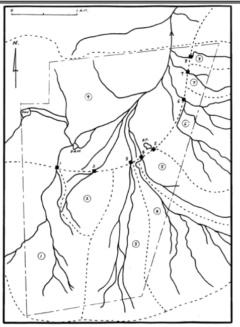
The drainage pattern is heavily influence by a number of lineations that traverse the site. These lineations are thought to represent major joint orientations, minor dykes and or the surface exposure of sills. The natural drainage pattern is a dendritic one with the main limbs corresponding in terms of orientation with these lineations (Figure 5.4). The drainage paths are ill-defined and typically comprise wide areas within broad gentle valleys that are discernible mostly by a change in vegetation type (see Section 5.2.1). No large drainage lines enter the site from beyond its boundaries and most of the surface catchment for the single main drainage line that leaves the site to the north east lies within the sites boundaries. The headwaters of the drainage lines along the eastern boundary do however extend beyond the boundary to some small extent.
The railway acts as a cut-off across the entire site which concentrates the flows through culverts beneath the railway. Berms have been placed above many of these culverts to divert water into them and have thus further modified the natural drainage pattern. Concentrated water flows will clearly occur where these culverts discharge. They however discharge directly onto the service road and no provision is made for water flows over or under the road. Each of the culverts caters for a distinct catchment area and these are added to by the catchment area to the north of the railway. These catchments and the corresponding culvert positions are shown Figure 5.4 below.
(1) Department of Water Affairs and Forestry. (1999) Aquifer Classification of South Africa, 1: 3 000 000. (2) Likelihood of contaminants reaching a receptor
Figure 5.4 Drainage Pattern, Culverts and Catchments
Key: Culverts are shown as square boxes along the railway line. Catchment areas are illustrated by numbers positioned beside the drainage lines.
For more details regarding the culverts (type and size of culvert) and catchments (i.e. area), see Annex J.
There are no perennial streams on the site and it is expected that running water would only be found during and immediately after significant rainstorms. The site however, was visited soon after a period of good rains but no surface water whatsoever was observed. A small, shallow dam has been excavated towards the north west corner of the site as shown in Figure 5.4. It is not expected to hold water very often or for very long.
Run-off within the site occurs over the entire site in the form of sheetwash with only a few short sections of narrow incised channels, generally less than 0.5 m deep and 0.5 m wide. These are to be found mainly in a small area between the eastern boundary and the railway line where it parallels it and
ENVIRONMENTAL RESOURCES MANAGEMENT AESSOLAR ENERGY LTD
where erosion of vehicle tracks running normal to the contours has occurred in the centre of the site.
5.2 BIOLOGICAL BASELINE
This section describes the existing biological environment within and around the Olyven Kolk site.
5.2.1 Flora
According to the national classification of the Vegetation of South Africa (Mucina & Rutherford, 2006), the entire site falls within a single vegetation type, Bushmanland Basin Shrubland (Figure 5.5). This is not a threatened vegetation and the conservation status of this vegetation type is classified as Least Threatened and less than 1% has been transformed (Mucina &
Rutherford 2006). The vegetation type is however not protected as none falls within a formal protected area.
Figure 5.5 Vegetation Map of Southern Africa showing Vegetation Types
Source: Source: Mucina et al. 2006, Key: Green area in which the site falls in Bushmanland Basin Scrub vegetation. See Annex F for detailed key.
The national vegetation map has been mapped at a very coarse scale and the map does not adequately reflect the vegetation pattern on the ground. This is exemplified by the fact that despite being classified as a shrubland, a
significant proportion of the site is in fact grassland with very little shrub cover. Several different habitats with characteristic plant communities can be discerned at the site. These are:
Calcareous Grassland;
ENVIRONMENTAL RESOURCES MANAGEMENT AESSOLAR ENERGY LTD
ENVIRONMENTAL RESOURCES MANAGEMENT AESSOLAR ENERGY LTD
5-10
Mixed Rocky Shrubland; and
Drainage Lines and run-on areas which are characterized by Rhigozum
and Lycium Thicket.
These are described further below. Overall, the vegetation of the site is relatively homogenous and a large proportion of the species present are common to all the different communities which were observed at the site and are described below. It is only the relative abundance of the common species or the presence of certain subdominant species which differentiate the
communities. The major driving variables of this differentiation are soil depth, substrate type and moisture availability which is usually related to landscape position.
The vegetation map derived from the satellite imagery of the site is depicted in Figure 5.6, below. It is clear that the different vegetation units are not always clearly differentiated from one another and there is a lot of patchiness with many small patches of one plant community scattered within another. Although the vegetation map certainly aids in the identification of the
drainage areas, those parts of the drainage areas that had not developed taller dense vegetation are mapped as Mixed Shrubland and ultimately, the
drainage areas were mapped, for the purposes of the sensitivity analysis by hand based on the notes and observations from the site visit. The Calcareous Grassland and Mixed Rocky Shrubland, are not differentiated in terms of the sensitivity map due to their similar sensitivity and also because they form a complex mosaic that occurs at much finer scale than the footprint and scale of flexibility of the development.
Figure 5.6 Fine-scale vegetation map of the site derived from Satellite Imagery
Source: Simon Todd, 2011
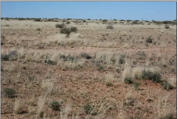
Calcareous Grassland
Areas of calcareous grassland occur scattered across the site, wherever the underlying calcrete is near to the surface or has been exposed. Plant cover is generally quite low and dominated by bushman grasses such as Stipagrostis ciliata and S.obtusa. Species richness in these areas is generally quite low as a result of the paucity of the shrub species present. An above average richness of geophytes was however observed. Since these areas usually occur in flat to very gently sloping areas, the risk or erosion or other detrimental disturbance effects is low. This community is considered to be of Low to Moderate Sensitivity.
This is the shortest and most open vegetation type at the site, and apart from scattered shrubs, rarely exceeds 40 cm in stature.
ENVIRONMENTAL RESOURCES MANAGEMENT AESSOLAR ENERGY LTD
Figure 5.7 Calcareous Grassland
The soil is usually very shallow with a lot of expose calcrete on the surface. The vegetation is low and open and dominated by Stipagrostis spp.
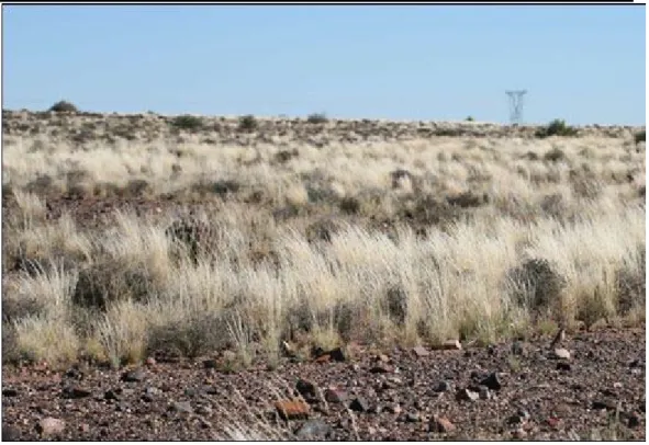
Mixed Rocky Shrubland
Rocky shrublands with a variably developed grass layer compose the largest proportion of the site. Cover varies from reasonably high to very low
depending on the nature of the underlying substrate. Fairly extensive stony plains largely devoid of plant cover occur in many areas within this vegetation type. At the time of sampling the abundance of grasses was very high as a result of the above-average rainfall the area had experienced, but during drier periods the shrub layer would be more conspicuous. Typical species include shrubs such as Eriocephalus spinescens, Pteronia sordida, Lycium cinereum and the forb Monsonia umbellata. Typical grasses include Stipagrostis ciliata, S.brevifolia, S.uniplumis and Aristida congesta. This community contained the highest species richness relative to the other communities. This is also a generally open and fairly low vegetation type, with the average height of shrubs being in the order of 40-50 cm. The proportion of larger elements such as Lycium and Rhigozum is generally low but increases in areas with above-average moisture availability, such as those areas which receive run-off from adjacent slopes.
This community was also the only one observed to contain species of
conservation concern such as Hoodia gordonii and Aloe claviflora. H. gordonii is listed as a protected species under NEMBA (Act 10 of 2004) as well as
provincial legislation while Aloe claviflora is protected in the Northern Cape Province in terms of the Northern Cape Nature Conservation Act, No. 9 of 2009.
ENVIRONMENTAL RESOURCES MANAGEMENT AESSOLAR ENERGY LTD
Figure 5.8 Mixed Rocky Shrubland
This is the dominant plant community across the majority of the site and is typically dominated by shrubs such as Eriocephalus and Pteronia with a grass component consisting largely of various Stipagrostis species as well as Aristida congesta.
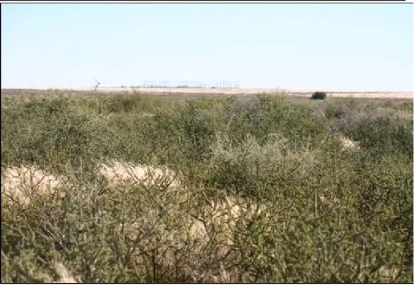
Rhigozum & Lycium Thicket
As previously indicated, the lower slopes and bottomlands of the site are the only areas which contain an appreciable amount of topsoil. These areas are dominated by taller shrubs such as Rhigozum trichotomum, Lycium cinereum and Phaeoptilium spinosum with an understorey of forbs and grasses. Common and dominant grasses within these areas included Stipagrostis ciliata, Schmidtia kalahariensis and Eragrostis porosa. The presence of this community is also indicative of the drainage areas of the site which are broad and diffuse as a result of the low overall slope of the area. Drainage lines at the site are not well developed as a result of the low slope and position of the site near the top of the catchment. These areas are the most impacted by livestock grazing as indicated by the high density of Lycium and Rhigozum which are known indicators of grazing pressure and degradation. However, since this
community represents a widespread plant community which occurs on coarse sandy soils throughout Bushmanland, it is not broadly characteristic of
drainage lines per se.
ENVIRONMENTAL RESOURCES MANAGEMENT AESSOLAR ENERGY LTD
Figure 5.9 Rhigozum Thicket
Only ccurs on the deeper soils which occur in the low-lying and drainage areas of the site. The community is dominated by Rhigozum trichotomum, Lycium spp and
Phaeoptilium spinosum.
The areas dominated by Rhigozum contained the lowest abundance of other plant species which can be ascribed to the negative effects of grazing as well as the suppression of the other plant species by Rhigozum. No plant species of conservation concern were observed within this habitat. Typically, the dominant woody shrub species in this community are around 1 m in height but may be as tall as 2 m indicating that at least the taller elements would probably need to be reduced in height to prevent shading the PV arrays.
ENVIRONMENTAL RESOURCES MANAGEMENT AESSOLAR ENERGY LTD
Figure 5.10 Rhigozum thicket community with a poorly developed grass layer
Poor developed grass layer is likely to be a result of heavy grazing and/or suppression of the grass layer by the dense Rhigozum stands.
5.2.2 Mammals, Reptiles and Amphibians
The site does not have a very rich faunal community, which can be ascribed to the arid nature of the area and the low variety of different habitats present at the site.
Mammals
Although over 40 mammals have distribution ranges which include the site, a large proportion of these are not likely to occur at the site due to the lack of suitable habitat. In particular, species associated with rocky outcrops are not likely to occur at the site such as Klipspringer, Rock Hyrax, Dassie Rat, Western Rock Elephant Shrew and Smith's Red Rock Rabbit.
The only antelope which occur at the site are Steenbok Raphicerus campestris and Common Duiker Sylvicapra grimmia.
Aardvark Orycteropus afer, Porcupine Hystrix africaeaustralis and Bat-Eared Fox Otocyon megalotis diggings and burrows were observed at the site during field investigatiosns indicting the presence of these species in the area. Although they were not observed during the site visit, other medium sized mammals likely to occur at the site include Caracal Caracal caracal, Black-backed Jackal Canis mesomelas, Cape Fox Vulpes chama and Aardwolf Proteles cristatus.
ENVIRONMENTAL RESOURCES MANAGEMENT AESSOLAR ENERGY LTD
ENVIRONMENTAL RESOURCES MANAGEMENT AESSOLAR ENERGY LTD
5-16
The small mammal community at the site is likely to be dominated by
widespread species such as the Four Striped Grass Mouse Rhabdomys pumilio, Namaqua Rock Mouse Micaelamys namaquensis, Cape Short-tailed Gerbil Desmodillus auricularis and Round-eared Elephant Shrew Macroscelides proboscideus. Species associated with sandy substrates such as Brants's
Whistling Rat Parotomys brantsii and Gerbillurus paeba will be largely restricted to the low-lying areas dominated by Rhigozum and Lycium vegetation. The overall abundance of small mammals at the site is likely to fluctuate widely from year to year depending on rainfall which regulates small mammal abundance through its effects on plant cover and food availability. Reptiles
The site lies in or near the distribution range of at least 40 reptile species, which is considered moderately low indicating that the site has a relatively depauperate reptile assemblage. Available data suggests that the site has a reptile fauna which is low in tortoises and snakes, but relatively rich in lizards, skinks and geckos, typical across bushmanland in general. Species associated large rocky outcrops such as Girdled Lizards (Cordylus spp) are not likely to be present at the site, while species which favour sandy, stony and open ground are likely to be dominant.
Although no reptile species which occur at the site are listed as endangered, the Bushmanland Tent Tortoise is protected under provincial ordinance and is also listed under Appendix II of Cites which regulates trade in these species. Amphibians
The site lies within or near the range of as many as nine amphibian species, although a number of these require more or less permanent water and are therefore extremely unlikely to occur at the site given the scarcity of water in the area. It is considered likely that only toad species such as the Karoo Toad Vandijkophrynus gariepensis occur at the site as these are able to tolerate
extended dry periods. The only potential breeding habitats at the site appear to be man-made and include a small earth dam, livestock watering troughs and temporary pools caused by the railway line preventing free flow of water across the site.
5.2.3 Ecological Sensitivity of Site
In terms of the distribution of the different ecological sensitivity categories at the site, those areas with deeper soils comprising the lower slopes and
bottomlands of the site are classified as High Sensitivity. These essentially
correspond to areas referred to as drainage lines. The poorly developed nature of the drainage areas at the site, can be ascribed to the position of the site at the very top of the catchment with little potential for runoff accumulation. Nevertheless, a cautious and conservative approach is warranted regarding the development potential of these areas. From a species richness perspective, these areas are not significant as plant diversity within these areas is low. Due
ENVIRONMENTAL RESOURCES MANAGEMENT AESSOLAR ENERGY LTD
5-17
to the deeper soils and landscape position of these areas, these areas would however be vulnerable to disturbance as this would render them susceptible to erosion. These areas are also important from a functional perspective because they provide cover for larger mammal species and would also serve as movement corridors. The presence of different vegetation units within an area is also ecologically important because each unit offers different resources and opportunities for the fauna at the site thereby contributing to the overall
diversity of the area. While parts of the site have been classified as High
Sensitivity, it should be noted that this is to a large extent relative to the other parts of the site. In absolute terms the site in general is low sensitivity when compared to high-biodiversity-value ecosystems with a high threat status or high levels of endemism.
The middle and upper slopes of the site as well as those low-lying areas with a
calcrete substrate are classified as Low to Medium Sensitivity. These areas
would be more tolerant of disturbance as there is little soil cover that could be displaced and the risk of erosion would be low. Some of these areas do however contain the highest levels of plant diversity present at the site, including at least two protected species (Hoodia gordonii and Aloe claviflora). Development within these areas could proceed with minimal overall ecological impact, provided that due attention is paid to translocating individuals of the protected species and other standard mitigation measures are applied.
0 250 500 750 1,000 Metres 94 0 960 92 0 940 940 20°50'0"E 20°50'0"E 20°49'0"E 20°49'0"E 20°48'0"E 20°48'0"E 20°47'0"E 20°47'0"E 2 9 °3 0 '0 "S 2 9 °3 0 '0 "S 2 9 °3 1 '0 "S 2 9 °3 1 '0 "S 2 9 °3 2 '0 "S 2 9 °3 2 '0 "S SIZE: TITLE: DATE: Oct 2011 DRAWN: LDT CHECKED: IE APPROVED: SHC PROJECT: 0126393 DRAWING: REV: A3 Figure 5.11
Ecological Sensitivity of the Olyven Kolk Site
Fig5.11_Ecological Sensitivity of the
Olyven Kolk Site.mxd 2
CLIENT:
±
SCALE: C :\ 0 1 2 6 3 9 3 _ A E S \M a p p in g \M X D \O c to b e r2 0 1 1 \F ig 5 .1 1 _ E c o lo g ic a l S e n s it iv it y o f th e O ly v e n K o lk S it e .m x dProjection: Geographic, Datum: WGS84
Source: EnPat (2001) Chief Directorate National Geo-Spatial Information (NGI)
Inset Map, Esri Data & Maps
SCALE: 1 : 20 000
It is unlawful for any firm or individual to reproduce copyrighted maps, graphics or drawings, in whole or in part, without permission of the copyright owner, ERM Southern Africa (Pty) Ltd ·
NAMIBIA BOTSWANA NORTHERN CAPE LIMPOPO EASTERN CAPE FREE STATE WESTERN CAPE NORTH WEST ZIMBABWE MOZAMBIQUE KWAZULU-NATAL MPUMALANGA LESOTHO GAUTENG SWAZILAND Legend Contours (20m) Secondary Roads Railway Line
Railway Service Road Olyven Kolk Site Ecological Sensitivity
Medium Medium - High High
AES Solar Energy
Study Area
ERM
175 Lunnon Road, Hillcrest. 0083 Pretoria, South Africa Tel: +27 12 362 0008 Fax: +27 12 362-8368
5.2.4 Birds
Avian Habitats
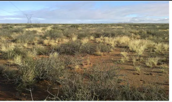
The habitat on site from an avian perspective is relatively uniform, dominated by open, flat, sandy Karoo veld (Figure 5.12), with thicker, woody growth along the main drainage lines. The lattice-type steel pylons which support the Eskom transmission power lines provide nesting habitat for birds that would normally nest in trees (e.g. passerines, corvids, raptors), and for birds that normally use nests built by these tree-nesting species (e.g. falcons).
The site is not located close to any established Important Bird Areas.
Figure 5.12 Typical flat, open Karoo Vegetation
Note: 400 kV transmission lines in the background
Avian Species
More than 130 bird species could possibly occur on the site, including up to 11 red-listed species, 56 endemics or near-endemics, and four red-listed endemics (Ludwig’s Bustard Neotis ludwigii, Black Harrier Circus maurus, Red Lark Calendulauda burra and Sclater’s Lark Spizocorys sclateri).
Red-listed species recorded in atlas data for the area include Kori Bustard Ardeotis kori, Ludwig’s Bustard Neotis ludwigii, Lanner Falcon Falco biarmicus and Sclater’s Lark Spizocory’s sclateri. A number of localised endemics also occur within the area (e.g. Black-eared Sparrowlark Eremopterix australis). The site falls within the documented range of the red-listed endemic Red Lark Certhilauda burra. The Rooiberg Dam, which is known to occasionally support numbers of flamingo, is located about 40 km to the north-east of the proposed development site.
ENVIRONMENTAL RESOURCES MANAGEMENT AESSOLAR ENERGY LTD
ENVIRONMENTAL RESOURCES MANAGEMENT AESSOLAR ENERGY LTD
5-20
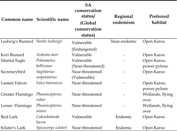
Nine species have been identified within the study area as ‘priority’ species based on their high abundance within the area, restricted range and/or their status as an endemic species.
Table 5.1 Priority Bird Species likely to be found within the Site
Common name Scientific name
SA conservation status/ (Global conservation status) Regional endemism Preferred habitat
Ludwig's Bustard Neotis ludwigii Vulnerable
(Endangered)
Near-endemic Open Karoo
Kori Bustard Ardeotis kori Vulnerable - Open Karoo
Martial Eagle Polemaetus bellicosus Vulnerable (Near-threatened) - Open Karoo, power pylons Secretarybird Sagittarius serpentarius Near-threatened (Vulnerable) - Open Karoo
Lanner Falcon Falco biarmicus Near-threatened - Open Karoo,
power pylons Greater Flamingo Phoenicopterus
ruber
Near-threatened - Wetlands, flying
over Lesser Flamingo Phoenicopterus
minor
Near-threatened - Wetlands, flying
over Red Lark Calendulauda
burra
Vulnerable Endemic Open Karoo
Sclater’s Lark Spizocorys sclateri Near-threatened Endemic Open Karoo
Eighteen bird species were recorded during the site visit. Significant observations included an adult Martial Eagle Polemaetus bellicosus perched near a nest in a transmission pylon on the western boundary of the site and a pair of Lanner Falcons at an old Martial Eagle nest on a pylon to the east of the site. The locations of these nests are shown in Figure 5.14.
Martial Eagle occupy a breeding territory approximately centred on the Aries substation. This has not generally been a productive territory, with breeding recorded only once in the period 2002 to 2006 (Jenkins et al. 2007). The presence of an adult eagle near a well built-up nest structure and some fresh droppings or whitewash accumulated under the nest pylon (Aries-Helios tower 11) suggests that the site may well be active this season.
Lanner Falcons do not build their own nests. When they nest in trees or equivalent man-made structures such as pylons, they usually use stick to nests built by other birds as platforms for breeding. The pair seen on site seemed interested in a second Martial Eagle structure on the Aries-Kronos line and it is likely that they may well breed on this nest later in the year.
Figure 5.13 Martial Eagle Nest on the Aries-Helios 400 kV Transmission Line
A Kori Bustard power line collision victim was found under the Aries-Helios Power line. Regional endemic species, such as Northern Black Korhaan Eupodotis afraoides Karoo Korhaan Eupodotis vigorsii, Rufous-eared Warbler Malcorus pectoralis probably occur commonly on the site, although only the latter species was seen during the site visit.
Figure 5.14 Distribution of Raptor Nests within the Site
Note: These nests are found on Eskom transmission lines
The worst affected taxa are likely to be the two raptor species (Martial Eagle and Lanner Falcon) resident and nesting on existing power transmission
ENVIRONMENTAL RESOURCES MANAGEMENT AESSOLAR ENERGY LTD
ENVIRONMENTAL RESOURCES MANAGEMENT AESSOLAR ENERGY LTD
5-22
pylons within the proposed development area. These birds (especially the eagles) will be significantly disturbed by the construction process, possibly to the extent of breeding failure or even territory abandonment. Based on their sensitivity it is considered that the development should be excluded from:
Within a 1 km radius of the Martial Eagle nest site; and
Within a 500 m radius of the Lanner Falcon nest site.
These areas to be excluded are shown in Figure 5.15 and discussed further in Annex G. Avoidance of these areas is advised as far as possible, whilst still ensuring that the project is feasible. If required, relocation measures as suggested by the expert may be followed.
5.2.5 Protected and Conservation Areas
There are no protected nature conservation areas within the site or near surrounds. There are a number of reserves and conservation areas within the wider region including: Augrabies Falls National Park (located approximately 90 km north west of the site) and Witsand Nature Reserve (located
0 250 500 750 1,000 Metres ! ! ! ! ! ! ! ! ! ! ! ! ! ! ! ! ! ! ! ! ! ! ! ! ! ! ! ! ! ! ! ! ! ! ! ! ! ! ! ! ! ! ! ! ! ! ! ! ! ! ! ! ! ! ! ! ! ! ! ! ! ! ! ! ! ! ! ! ! ! ! ! ! ! ! ! ! ! ! ! ! ! ! ! ! ! ! ! ! ! ! ! ! ! ! ! ! ! ! ! ! ! ! ! ! ! ! ! ! ! ! ! ! ! ! ! ! ! ! ! ! ! ! ! ! ! ! ! ! ! ! ! ! ! ! ! ! ! ! ! ! ! ! ! ! ! ! ! ! ! ! ! ! ! ! ! ! ! ! ! ! ! ! ! ! ! ! ! ! ! ! ! ! ! ! ! ! ! !
[
b
[
Ç
94 0 960 920 940 20°50'0"E 20°50'0"E 20°49'0"E 20°49'0"E 20°48'0"E 20°48'0"E 20°47'0"E 20°47'0"E 2 9 °3 0 '0 "S 2 9 °3 0 '0 "S 2 9 °3 1 '0 "S 2 9 °3 1 '0 "S 2 9 °3 2 '0 "S 2 9 °3 2 '0 "S SIZE: TITLE: DATE: Oct 2011 DRAWN: LDT CHECKED: IE APPROVED: SHC PROJECT: 0126393 DRAWING: REV: A3 Figure 5.15Bird Exclusion Zones
Fig5.15_Bird Exclusion Zones.mxd 2
CLIENT:
±
SCALE: C :\ 0 1 2 6 3 9 3 _ A E S \M a p p in g \M X D \O c to b e r2 0 1 1 \F ig 5 .1 5 _ B ir d E x c lu s io n Z o n e s .m x dProjection: Geographic, Datum: WGS84
Source: EnPat (2001) Chief Directorate National Geo-Spatial Information (NGI)
Inset Map, Esri Data & Maps
SCALE: 1 : 20 000
It is unlawful for any firm or individual to reproduce copyrighted maps, graphics or drawings, in whole or in part, without permission of the copyright owner, ERM Southern Africa (Pty) Ltd ·
NAMIBIA BOTSWANA NORTHERN CAPE LIMPOPO EASTERN CAPE FREE STATE WESTERN CAPE NORTH WEST ZIMBABWE MOZAMBIQUE KWAZULU-NATAL MPUMALANGA LESOTHO GAUTENG SWAZILAND Legend
[
b
Lanner Falcon Bird's Nest[
Ç
Martial Eagle Bird's NestContours (20m) Secondary Roads Railway Line
Railway Service Road
! ! Existing 400kV Transmission Lines
Bird Exclusion Zones 500m Buffer 1000m Buffer
Eskom Aries Sub-station Olyven Kolk Site
AES Solar Energy
Study Area
ERM
175 Lunnon Road, Hillcrest. 0083 Pretoria, South Africa Tel: +27 12 362 0008 Fax: +27 12 362-8368