Ordination as a tool for substantiating and interpreting floristic
classifications: a case study
G.B. DEALL* and G.K. THERON**
Keywords: classification. Detrended Correspondence Analysis, ecological interpretation, ordination, PHYTOTAB
ABSTRACT
Detrended Correspondence Analysis ordination is used as a tool for substantiating the authenticity of hierarchical syntaxa derived from a phytosociological classification of the vegetation of the Eastern Transvaal Escarpment in the Sabie area. Ecological interpretation of syntaxa is facilitated by superimposing environmental variables on axes of ordination.
UITTREKSEL
Ordinasie deur middel van Ontneigde Ooreenstemmingsanalise is gebruik ter ondersteuning van die geldigheid van die hiërargiese sintaksons wat verkry is met fitososiologiese klassifikasie van die plantegroei van die Oos-Transvaalse Eskarp in die omgewing van Sabie. Die ekologiese interpretasie van sintaksons is vergemaklik deur die aanbring van omgewings- veranderlikes langs die asse van ordinasie.
INTRODUCTION
In phytosociological classification the possibility always exists that groupings are controlled by the ecologist rather than by structure internal to the data (Gauch & Whittaker
1981). Most community data sets have two to four gradients and in this dimensional range hierarchical classification tends to be weak. Ordination, on the other hand, is especially strong in this range and may complement classification for such data (Gauch 1982). Ordination is therefore a useful adjunct to classification, facilitating an a posteriori basis for determining whether Braun-Blanquet syntaxa are real, naturally occurring entities, or whether they are mere artefacts of data arrangement. Through its ability to portray similarity relations geometrically, ordination is also useful for emphasising inter-community relationships (Mucller-Dombois & Ellenberg 1974). Fur thermore, by imposing environmental variables upon the axes of ordination, the ecological interpretability of vegetation can be enhanced.
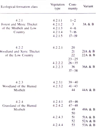
A Braun-Blanquet phytosociological classification of vegetation in the Sabie area by Deal I (1985) using PHYTOTAB (Westfall et al. 1982) revealed 62 basic syntaxa (comprising communities and variants) distributed through a hierarchy of 14 vegetation types and four ecological-formation classes (Table 1).
The aim of this paper is to determine, by means of ordination, whether these syntaxa (especially at vegetation- type level) really represent the vcgetational entities in nature. Inter-community relationships and environmental interpretations are also considered.
METHODS
Ihe 62 syntaxa of Deal I (1985) were ordinated on floristic data using Detrended Correspondence Analysis
* National Botanical Institute, Private Bag X101, Pretoria 0001. Present address: Africa School of Missions, P.O. Box 439, White River 1240. ** Department of Botany, University of Pretoria 0002.
MS. received: 1989.04.25.
(DCA) (Hill & Gauch 1980). The latter was effected using the DECORANA program (Hill 1979), which is dependent on inputs from various programs of the PHYTOTAB com puter package (Westfall et al. 1982). The ordination involved the arrangement of plant communities by group values (to the nearest 0,5 sd). Four different ordinations were undertaken on the basis of four data subsets corresponding to the four ecological-formation classes. Relationships between communities and environmental variables usually defy analysis by conventional statistical
TABLE 1.—Hierarchical arrangement of syntaxa in the Sabie area of the Eastern Transvaal Escarpment (from Deall 1985)
Ecological-formation class Vegetation type
Com
munity Variant
4.2.1 4.2.1.1 1-2
Forest and Mesic Thicket 4.2.1.2 3 3A & B of the Mistbelt and Low 4.2.1.3 4 - 6
Country 4.2.1.4
4.2.1.5 7-16 17-19
4.2.2 4.2.2.1 20
Woodland and Xeric Thicket 21 21A & B of the Low Country
4.2.2.2 22 2 3 -2 5 2 6 -3 5
22A & B
4.2.2.3 36 37-38
36A & B
4.2.3 4.2.3.1 3 9 -4 0 Woodland of the Humid 4.2.3.2 41-43
Mistbelt 44 44 A & B
4.2.4 4.2.4.1 4 5 -4 6 Grassland of the Humid 4.2.4.2 47 -4 8
Mistbelt 49
50
49A & B
4.2.4.3 51 52
224
methods and are mostly perceived by informal, visual recognition of common patterns of distribution (Gauch
1982). One way of portraying such patterns is to super impose environmental variables on axes of community ordination (Westfall 1983).
Environmental variables recorded during sampling were accordingly superimposed on each ordination diagram. Those variables exhibiting a definite gradient along ordination axes were retained as being important in community differentiation, whereas others were discarded. Ordination axes were selected on the basis of their having sufficient variance to represent inherent data structure (Hill 1979) and their propensity to exhibit maximal vegetational variation (based on ‘spread’ of syntaxa).
The ordination of plant communities (and variants) is discussed in the context of their respective ecological- formation classes, or data subsets. It must be noted that the terms used for indicating environmental gradients in the ordination diagrams (Figures 1 -4 ) are not absolute, but relative. That is, the scale of an environmental feature on one axis is not necessarily the same as it is on the other axis. For example, ‘deep’ on the x axis may be the same depth as ‘shallow’ on the y axis.
RESULTS AND DISCUSSION
Forest and Mesic Thicket of the Mistbelt and Low
Country (4.2.1.)
Axes 1 and 3 in Figure 1 form the ordination axes of the scatter diagram which represents relationships between vegetation and environment in the 19 communities com prising the Forest and Mesic Thicket of the Mistbelt and Low Country subset. Together these axes account for 69,4% of the variance. Gradient lengths of the first three axes are slightly less than 4,0 sd, indicating a moderately high beta diversity for Forest and Mesic Thicket of the Mistbelt and Low Country [samples with a separation of
Low Dry Warm
Deep Less rocky
A L T IT U D E /C L IM A T E
Exposed High Moist Cool L IT H O L O G Y
SO IL Shallow Rocky
=
0.5-■
©
V E G .T Y P E , VEG . T Y P E4 .2 .1.5 .
©
©
©
- ( § )
© © ©
©! ® |
V E G .T Y P E V EG T Y P E I V E G .T Y P E 1- ©
©
4 .2 .1.4 . 4 .2 .1.3. ©
1 4 2 .1 .2 . ' I
Deep 1,0 1,5 2,0
Ax i s i (sd units)
3.0
FIGURE 1,—Detrended Correspondence Analysis (DCA) ordination of the 19 plant communities comprising Forest and Mesic 1 hicket of the Mistbelt and Low Country, Sabie area. Axes 1 and 3 represent the main environmental gradients as shown.
greater than 4,0 sd will generally have no species in common (Hill 1979)].
Community separation on the basis of vegetation type is indicated in the ordination diagram by means of the broken lines (Figure 1). Apart from the placement of Community 17 into Vegetation Type 4.2.1.4 (Table 1), the identity of the five vegetation types associated with Forest and Mesic Thicket of the Mistbelt and Low Country is faithfully maintained by the ordination. Thus the classifica- tory basis of the vegetation-type category is, for the most part, confirmed.
Some of the environm ental gradients possibly influencing community differentiation in Forest and Mesic Thicket of the Mistbelt and Low Country are indicated in relation to axes 1 and 3 of the ordination diagram (Figure 1). Axis 1 corresponds predominantly to a temperature/moisture/lithology gradient, whilst axis 3 appears to reflect a soil-depth gradient.
Forest vegetation is uniformly represented along both axes (Figure 1). Whereas forest Communities 1 to 6 are associated with the moist, cool conditions of higher altitudes, forest Communities 17 to 19 are associated with the dry, warm conditions of lower altitudes (axis 1, Figure 1). Thus forest ostensibly exhibits a wide moisture tolerance. In reality, however, Communities 17 to 19 are confined to sheltered riparian sites where, despite surrounding aridity, moisture is non-limiting.
The isolation on axis 1 of forest Community 3 is probably due to both the shallow, rocky quartzite-derived soil, and the exposed sites to which the Community is confined (Figure 1). By contrast, forest Communities 1 and 2 occur on deeper dolomite-derived soils in more sheltered sites, whereas Communities 4 to 6 occur on deeper granite-derived soils, also in more sheltered sites.
Mesic Thicket (Vegetation Type 4.2.1.4) is confined to the portion near the origin of each axis (Figure 1). Constituent syntaxa (Communities 7 to 16) are conse quently grouped in the lower left sector of the ordination diagram, corresponding to conditions that are not sufficiently moist to sustain forest. The anomalous occurrence of forest Community 17 in the ‘d rier’ sector of the diagram may reflect a moisture deficit relative to Communities 18 and 19. Whereas the soils of the two latter communities have a high clay fraction in the lower horizons, those of Community 17 consist mainly of sand. The water-holding capacity of soils in Community 17, therefore, is likely to be less than in Communities 18 and
19.
Woodland and Xeric Thicket of the Low Country
(4.2.2)Axes 1 and 2 in Figure 2 form the ordination axes of the scatter diagram which represents relationships between vegetation and environment in the 19 communities comprising ihe Woodland and Xeric Thicket of the Low Country subset.
Bothalia 20,2 (1990)
indicating a moderately low beta diversity for Woodland and Xeric Thicket of the Low Country.
The identity of the three vegetation types associated with Woodland and Xeric Thicket of the Low Country is faith fully maintained by the ordination (Figure 2). The clas- sificatory basis of the vegetation-type category is therefore confirmed.
Some of the environmental gradients possibly influencing community differentiation in Woodland and Xeric Thicket of the Low Country are indicated in relation to axes 1 and 2 of the ordination diagram (Figure 2). Axis 1 corresponds to a temperature/moisture/exposure gradient, whereas axis 2 reflects a similar gradient com pounded with soil depth and slope. The net effect of these gradients is a gradient corresponding to the positive diagonal and operating from cool moist conditions, with shallow rocky soils on exposed steep slopes (upper right); to warm dry conditions, with deep, less rocky soils on sheltered gentle slopes (lower left).
The low open/sparse woodland and the short sparse shrubland communities of Vegetation Type 4.2.2.3 are clearly correlated with the shallow rocky soils on exposed steep slopes (Figure 2). Vegetal cover in this part of the gradient is accordingly low. As these habitats become warmer, drier, and more sheltered, the vegetation becomes more woody, resulting in the woodland and thicket com munities of Vegetation Type 4.2.2.1. On the more gentle slopes with deepish, less rocky soils (lower left and right, Figure 2), land is more arable, more inviting for human settlement, and more susceptible to fire. Attendant vege tation is therefore likely to be disturbed. This may explain the sparsely woody nature of Vegetation Type 4.2.2.2.
Woodland of the Humid Mistbelt
(4.2.3)Axes 1 and 2 in Figure 3 form the ordination axes of the scatter diagram which represents relationships between
vegetation and environment in the six communities comprising Woodland of the Humid Mistbelt subset.
These axes account for 89,2% of the variance. Gradient lengths of the first two axes are slightly higher than those for Woodland and Xeric Thicket of the Low Country, but less than those for Forest and Mesic Thicket of the Mistbelt and Low Country. Beta diversity in Woodland of the Humid Mistbelt is therefore relatively intermediate between the mesic and the more xeric ecological-formation class.
Clearly, the identity of the two vegetation types associated with Woodland of the Humid Mistbelt is faithfully maintained by the ordination (Figure 3). Thus the classificatory basis of the vegetation-type category is confirmed.
Some of the environm ental gradients possibly influencing community differentiation in Woodland of the Humid Mistbelt are indicated in relation to axes 1 and 2 of the ordination diagram (Figure 3). Axis 1 corresponds to a geomorphology/geology/exposure gradient, and axis 2 reflects a temperature/moisture gradient.
The low open woodland and low thicket associated with Communities 39 and 40 apparently develops in response to a high soil-moisture status occasioned by the deep clay soils of sheltered midslope planes (Figure 3). Their association with dolomite, moreover, is reminiscent of the tall/short forest represented by Communities 1 and 2, and it is therefore possible that Communities 39 and 40 are serai to these forest communities.
On the shallow and sandy quartzite-derived soils of exposed and rocky upper-pediment slopes, soil-moisture is more limiting. Vegetation response is accordingly towards a closed/open woodland with low vegetal cover (Communities 41 to 44, Figure 3). Supplementary moisture in the form of ‘fog-drip’ (Deall et al. 1989),
Sheltered Low Warm Dry
EXPOSURE
A LTITUD E / CLIM ATE
Exposed High Cool Moist
Shallow Rocky Steep
Deep
Less rocky Gentle
Bothalia 20,2 (1990)
Upper ped. slope
Q u artzite Shallow Rocky sand Gentle Exposed
GEOM ORPH OLO GY LITH O LO G Y
SO IL
-4---- S L O P E
"3 2'5
I 2.0
T3 <£ 1,5
(M
« 1.0
■* 0.5
0.0
Midslope plane Dolomite
Deep Less rocky
Clay Steep S h eltere d
V EG . T Y P E 4. 2 .3 .2 .
V E G . T Y P E 4. 2 .3 .1.
Low vegetal cover High vegetal cover
© ©
©
H igh Moist I Cool
I Low I Dry _ Warm 1,0 1,5 2.0
A x is 1 (Sd units)
FIGURE 3.—Detrended Correspondence Analysis (DCA) ordination of the six plant communities comprising Woodland of the Humid Mistbelt, Sabie area. Axes l and 2 represent the main environ mental gradients as shown.
especially at the higher altitudes of Communities 43 and 44. may provide some stimulus for the succession to develop towards the elfin-like forests represented by Community 3.
G rasslan d of the H um id M istbelt (4.2.4)
Axes l and 2 in Figure 4 form the ordination axes of the scatter diagram which represents relationships between vegetation and environment in the nine communities comprising the Grassland of the Humid Mistbelt subset.
These axes account for 89,7% of the variance. Gradient lengths of the first two axes range from 2,76 to 3,78 sd, indicating a slightly higher beta diversity than other ecological-formation classes.
Vegetation Type 4 .2 .4 .1 (Communities 45 and 46) is the only one in Grassland of the Humid Mistbelt, the identity of which is not maintained by the ordination. Rather, it tends to merge with two others, namely Vegetation Types 4.2.4.2 and 4.2.4.3 (Figure 4). This suggests that Vegeta
tion Type 4 .2 .4 .1 may be a classificatory artefact, with lithology and physiography playing a much less signifi cant role in community differentiation than is indicated by the phytosociological classification.
Some of the environmental gradients influencing com munity differentiation in Grassland of the Humid Mistbelt are indicated in relation to axes l and 2 of the ordination diagram (Figure 4). Axis l apparently corresponds to a soil-texture/lithology/geomorpholgy gradient, whereas axis 2 appears to reflect a soil-depth/lithology/geomor- phology gradient. The net effect of these gradients is a geomorphology gradient corresponding to the positive diagonal, and operating from upper-pediment slopes (lower left) to midslope planes (upper right); and also a lithology gradient corresponding to the negative diagonal, and operating from dolomite (upper left) to quartzite (lower right).
On the positive diagonal (Figure 4), Communities 49 and 50 are possibly separated from the other communi ties on the basis of an improved soil-moisture status, reflecting their lower position in the landscape. On the negative diagonal (Figure 4), Communities 46 to 48 and 50 appear to be separated from the other communities by virtue of their sandy quartzite-derived shallow soils, which soils are in contrast with the deeper, dolomite-derived clay soils of their counterparts (Communities 45, 49 and 51 to 53).
Community 50 appears on the diagram as an outlier (Figure 4). This may reflect its disturbed character, being situated in a municipal area where human influences arc manifold.
CONCLUSIONS
Only one out of 14 vegetation types derived from the phytosociological classification of vegetation in the Sabie area could not be substantiated by ordination. Syntaxa at the vegetation-type level are therefore considered to be authentic. In order to substantiate the validity of syntaxa at the community and variant level, it would be necessary to ordinate their component sample plots.
U pper ped slo p e D o lo m ite C la y «---H igh <
---G E O M O R P H O L O ---G Y L IT H O L O G Y
Midslope - ► Q u a rtz ite - » San d -»■ Low
0,5
-(49A^,
V E G . T Y P E S 4 . 2 . 4 . 1 .
a
4 .2 . 4 .2 . ' 5 0 ) 5
1,0 1 , 5 2 ,0 2 ,5 A x is 1 (Sd u nits)
3 ,0
Deep M idslope
Le ss ro c k y plan e D olo m ite
Shallo w R ocky
Upper ped slo pe
Bothalia 20,2 (1990)
Superimposition of environmental variables on com munity ordination axes enhances the ecological inter- pretability of floristic classifications. Environmental gradients affecting community differentiation are thus identified and successional trends become more apparent.
ACKNOWLEDGEMENTS
Discussions with Dr J.C. Scheepers and Mr R.H. Westfall helped crystallize some of the theoretical concepts. Drawings were all done by Mrs J. Schaap.
REFERENCES
DEALL, G.B. 1985. A plant-ecological study o f the Eastern Transvaal Escarpment in the Sabie area. M.Sc. thesis, University of Pretoria.
DEALL, G.B., SCHEEPERS, J.C. & SCHUTZ, C.J. 1989. The vege tation ecology of the Eastern Transvaal Escarpment in the Sabie area. 1. Physical environment. Bothalia 19: 53—67.
GAUCH. H.G. Jr 1982. Multivariate analysis in community' ecology.
Cambridge, Cambridge University Press.
GAUCH. H.G. Jr & WHITTAKER, R.H. 1981. Hierarchical classifica tion of community data. Journal o f Ecology69: 537-557. HILL. M .O. 1979. DECORANA— A FORTRAN program fo r detrended
correspondence analysis and reciprocal averaging.Unpublished report. Ecology and Systematics, Cornell University, Ithaca, New York.
HILL, M.O. & GAUCH. H.G. Jr 1980. Detrended Correspondence Analysis: an improved ordination technique. Vegetatio42: 47—58. MUELLER-DOMBOIS, D & ELLENBERG, H. 1974. Aims and
methods o f vegetation ecology. John Wiley, New York. WESTFALL, R.H. 1983. The plant ecology of the farm Groothoek,
Thabazimbi District. 1. Ordination. Bothalia 14 : 785 -789. WESTFALL. R.H.. DEDNAM, G., VAN ROOYEN, N. &THERON,