An Executive Overview
Cloud-based Data Management
for Quick Asset Valuation,
Opportunity Identification and
Risk Quantification
Identify, Quantify and Collaborate
Anywhere, Anytime
Alan Lindsey
CEO
Lindsey, Robertson & Associates
It can take days to access the data needed
You needed the answer yesterday
The upstream Oil & Gas industry is witnessing an explosion of data, which is growing exponentially due to the development of digital oilfields and more frequent data collection. As global competition for depleting resources continues to drive the need to lower operating costs and increase finding and recovery rates, improvements in data management and collaboration are a must.
E&P companies are being challenged to effectively capture, store, manage, analyze and deploy data for upstream assets. Consider a company with 10,000+ E&P professionals. If you could save just 20% of upstream professionals’ time through better accessibility and integration of data, it would translate to an estimated savings of approximately half a billion dollars per year. This would have a tremendous impact on the bottom line.
The keys to reducing the time spent by upstream professionals on evaluating plays identifying opportunities can be summarized as follows:
One stop data store with fine-tuned search capabilities for locating all relevant data for an exploration play
Charting and annotation tools to integrate interpreted data with current statistics Secure remote systems capabilities to enable team members from within the
organization and from third parties to collaborate and share knowledge Integrating work of specialists with data room teams by leveraging the web
Data collection
The ability to locate all relevant data for an exploration play can make the difference in assigning the correct assumptions to your reservoir characterization and the models constructed to simulate its performance. More data is better and the ability to find relevant data is vital. However, the number of information sources is staggering, with multiple data repositories both inside the company and from third party resources – all containing terabytes of structured and unstructured information. It can take days to access the data needed. The challenges facing data collection in the Oil & Gas industry are:
a company with 10,000+ employees
saves 20% of time spent on data activities
Savings of $500,000,000
IHS HPDI
Logline DI
SEI NOGA
Public
Proprietary
Petra
SMT
Landworks
ArcGIS MJ
PHDWin
Excalibur
Communication
Gap
Reconnaissance
Collaboration
Analysis
PowerPoint
the challenge isbringing together the collaborative work done by interdisciplinary team members so that it is easily accessible
Difficulty merging and managing data from live and archived legacy systems in a timely manner
Securely storing and managing proprietary data assets Disparate process and content data
Asset valuation
Good business decisions are made after careful data analysis, risk quantification and collaborative discussions. All of this takes time and time is valuable. When deciding whether a new play is worth pursuing or a location is worth drilling, extensive data gathering and research is required, followed by expert interpretation. Before any drilling decision can be made, analyzed data and statistics need to be shared and communicated with your team, sometimes requiring several review meetings and often with team members spread across the globe. Key challenges facing analytics are:
Difficulty generating real-time statistics
Presentation ready displays for quantifying activity and productivity Quantifying risk
From acquisition and interpretation to drilling decision
The best decisions are fed by data from many sources, then interpreted by experts using sophisticated tools and reviewed again and again by both technical and non-technical personnel. The challenge is bringing together the collaborative work done by interdisciplinary team members so that it is easily accessible by the entire team regardless of physical location. In today’s highly competitive global economy, interdisciplinary teams across companies are the norm, which means decision makers are spread across the globe. Reconnaissance, collaboration, and analysis are an important part of the drilling decision process. Without cloud-based technology, a communication gap exists between integrating the data, expert interpretation and the presentation of your team’s collaborative work to the decision makers. Often, huge travel budgets are required so that team members can come together to share ideas and strategize.
Search by Formation and
•IP
•BOEVD (set your own value) •GOR
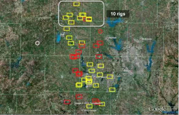
•Rig Locations •Well Count •Well Activity •Geography
Search by Operator and •IP •BOEVD •GOR •Rig Locations •Well Status •Well Activity •Infrastructure
Search by Location
•Fields •Counties •Leases •Cities the world’s first petroleum decision engine
Identify, Quantify, and Collaborate - Anywhere, Anytime
The world’s first petroleum decision engine: a powerful cloud-based platform for
making collaborative, data-driven decisions using shared maps, charts, and
documents has been developed by Lindsey, Robertson & Associates, LLC. The tool,
called Petro
DE
, combines analytics, situational awareness, and collaboration to
facilitate rapid decisions. It has highly advanced search capabilities, as well as the
ability to display Monte Carlo statistics, charts, maps, and user created annotations
on a secure communication platform. Proprietary data and presentation ready
displays are securely stored in the cloud, making it easily accessible for all team
members around the globe. This
War Room in the Cloud
is the go to tool for:
Opportunity Identification
Asset Valuation
Risk Quantification
Situational Awareness
Secure Model Collaboration
Extensive search capabilities in record time
Time is of the essence when drilling decisions are being made. It can take days to access proprietary data in the petroleum industry. With secure cloud-based technology, data collection of both proprietary and public data can be fine-tuned to suit the needs of your business on a highly encrypted platform that is accessible to both technical and non-technical team members.
PetroDE has extensive search capabilities that span across multiple licensed databases including IHS and DIDesktop. You may integrate your company specific data and public data layers into our system and visually organize and display information at the click of a button. Queries on current data are run in a fraction of the time it takes to query and download from other commercial databases. Searches can be saved for later use on a highly encrypted server in the cloud. This means that a specific search can be later viewed by a team member down the hall or on the other side of the globe. Searches available:
Chart Statistics •Resource Play Statistics:
•IP Performance •Productivity •Cost histograms •GOR based on IP •Drilling Activity including:
•Depth histograms •IP well count
Add Map Data from Public Sources •Oil and Gas Assessment •World Energy Provinces •World Oil Refineries •World Stress Map •Geologic formations •Public Lands
•Critical Habitat •Weather •Market
Add Company Proprietary Data •Highly encrypted and private to your team •Share and Discuss across
the Globe
Asset valuation
Before any drilling decision can be made, analyzed data and statistics need to be shared and worked by the asset team. PetroDE has the ability to display search results on both charts and maps making it easy to share findings and transfer results to a presentation. Constraints that need to be
considered such as public lands and weather can be overlaid on proprietary data layers increasing a team’s understanding of field circumstances. PetroDE also allows you to select multiple areas of interest for analysis, allowing for valuation and risk to be assessed at the click of a button. All data layers can be saved in a highly encrypted storage location in the cloud for later use by your team members regardless of their location around the globe.
Situational Awareness
Knowledge of where formations are being played and which operators are active allows for incomparable competitor analysis. PetroDE leverages the synergies between the Google Earth API and your licensed and proprietary data, as well as additional provided public geologic, weather and market data layers.
far flung employees can collaborate on the same map in real time from anywhere in the world
Figure 2. Rigs Drilling in the Barnett
Annotation
An area of interest is not always a specific geographic location and when a query requires a special search area, PetroDE allows you to annotate a specific location with its polygon editing tool. The annotation tool allows the drawing of polygons, text and arrows. Presentations are easily enhanced with these features. For example, add an arrow to a map to point to a specific well, or add text to a chart to highlight an interesting statistic. Annotations can be saved for future reference.
Secure model collaboration
Sometimes it is not possible for all members of a team to be in one geographical location. The collaboration tool within PetroDE uses the latest encryption technology available to ensure secure storage of proprietary data layers in the cloud. This means that far flung employees can collaborate on the same map in real time from anywhere in the world, thus cutting costly travel budgets. Multiple users can join in your collaboration using a highly encrypted connection. To further aid with communication, you can draw on the map using the annotation tool to express your point more clearly.
IHS HPDI
Logline DI
SEI NOGA
Public
Proprietary
Petra
SMT
Landworks
ArcGIS MJ
PHDWin
Excalibur
Filling the
Communication
Gap
Reconnaissance
Collaboration
Analysis
PowerPoint
Filling the communication gap
With its search, display, collaboration, and annotation capabilities, PetroDE fills the communication gap integrating your data, statistics, and interpretation to be easily accessible to your team on a secure cloud-based communication platform.
In a nutshell, PetroDE is your petroleum decision engine tool for cloud-based asset valuation, risk quantification and opportunity identification. It can:
Quickly identify play hot-spots and generate Monte Carlo statistics Easily quantify operator activity and productivity
Cloud-based map and analytics available anywhere, anytime, to support collaborative decision-making
To find out more about how you can use this War Room in the Cloud, click here.
About us
Lindsey, Robertson & Associates, LLC is a small software development company that produces and markets cloud-based mapping and asset management solutions. We believe the effectiveness of information depends on its analytical quality, accessibility, and clarity of presentation.
PetroDE was born as a result of needs in the petroleum industry to better understand breaking resource plays and locate new opportunities. The classic paper war room map was cluttered by multiple layers of paper information from various sources, and was not available away from the office. Countless hours and days were spent looking for data and waiting for maps from technical support staff scattered across the globe. The time had come for major change. As a result, we decided to create a tool that leverages all of the latest technologies from cloud servers and storage, to Google Earth mapping, to statistical decline curves and shared maps. The result is a powerful, user-friendly tool called PetroDE. Our team has an extensive background in the geosciences, software development, and economics, with more than 66 years of combined experience. Together our goal is to give you a tremendous edge in the quest for oil & gas by making your most important information available to your entire team anywhere, anytime.
Our company has close ties with the University of Colorado with access to its deep talent pool. This means we can provide you with the latest in technology via an energetic staff willing to stay up all night if that’s what it takes to get the job done. This young team is guided by highly experienced industry veterans determined to make the petroleum industry more effective in finding and developing the world’s future resources.
Alan Lindsey is the founder and CEO. He is a geoscientist who has developed resource plays on three continents. He developed key metrics and scoring methods for identifying core shale play acreage and applied the method to the Eagle Ford, Marcellus, Utica, and Barnett shale systems - greatly simplifying acreage evaluation. Prior to focusing on resource plays, Alan explored for conventional resources for Shell E&P from California to the Deepwater Gulf of Mexico. Alan received a B.S. in Geophysical Engineering from the Colorado School of Mines, and has more than 27 years of experience in the oil & gas business.
Keith Robertson, the Lead Developer manages PetroDE’s cloud-based servers and databases and oversees programming of new features while ensuring stability of the overall system. He is also responsible for human resource management and hiring new talent. Keith previously completed a number of major web development projects for other organizations. These projects included a portal that improved record keeping and file management to improve communication between lawyers and their clients. In addition, he worked at the Colorado Space Grant Consortium to record fluctuations in atmospheric
density using neutral mass spectrometers. He is currently studying electrical and computer engineering at the University of Colorado at Boulder.
Contact Us
Lindsey, Robertson & Associates, LLC 2885 Aurora Ave.
Boulder, CO 80303 USA
Website: www.PetroDE.com Email: [email protected]