Article
Landslide Susceptibility Modeling Based on GIS and
Novel Bagging-Based Kernel Logistic Regression
Wei C hen ^ *, H im an Shahabi 2,*! , Shuai Zh an g 1, K h ab at K h o sra v i3 , A taollah S h irz a d i4 , K am ran C h a p i4 , Binh Thai P ham 5, Tingyu Zh an g 6, Lingyu Z hang 1, H uichan Chai 7, Jian q u an M a 1 , Yingtao C hen 1, X iaojin g W ang 1, R enw ei L i 1 and B aharin Bin A hm ad 8
1 College of Geology & Environment, Xi'an University of Science and Technology, Xi'an 710054, China; [email protected] (S.Z.); [email protected] (L.Z.); [email protected] (J.M.); [email protected] (Y.C.); [email protected] (X.W.); [email protected] (R.L.)
2 Departments of Geomorphology, Faculty of Natural Resources, University of Kurdistan, Sanandaj 66177-15175, Iran
3 Department of Watershed Management, Faculty of Natural Resources, Sari Agricultural Sciences and Natural Resources University, Sari 48181-68984, Iran; [email protected]
4 Department of Rangeland and Watershed Management, Faculty of Natural Resources, University of Kurdistan, Sanandaj 66177-15175, Iran; [email protected] (A.S.); [email protected] (K.C.)
5 Institute of Research and Development, Duy Tan University, Da Nang 550000, Vietnam; [email protected]
6 School of Earth Science and Resources, Chang'an University, Xi'an 710064, China; [email protected] 7 School of Earth and Environment, Anhui University of Science & Technology, HuaiNan 232001, China;
8 Faculty of Built Environment and Surveying, Universiti Teknologi Malaysia (UTM), Johor Bahru 81310, Malaysia; [email protected]
* Correspondence: [email protected] (W.C.); [email protected] (H.S.); Tel.: +98-9186658739 (H.S.)
©
check for^ updates
A bstract: Landslides cause a considerable am ount of dam age around the w orld every year. Landslide
su scep tibility assessm en ts are u sefu l for the m itig atio n o f the asso ciated p o ten tial risks to local eco n om ic d ev elo p m en t, land use p lan n in g , an d d ecisio n m ak ers. The m ain aim o f this stu d y w as to p resen t a n o vel h yb rid ap p ro ach o f b ag g in g (B )-b ased k ern el lo g istic regressio n (K L R ), n am ed the B K L R m o d el, for spatial p red ictio n o f lan d slid es in the Sh an g n an C ounty, C hina. W e first selected 15 conditioning factors for landslide susceptibility m odeling. Then, the prediction capability of all co n d itio n in g factors w as ev alu ated u sin g th e least squ are su p p o rt v ecto r m achin e m ethod . M od el v alid atio n and co m p ariso n w ere perfo rm ed b ased on the area u n d er the receiver o p eratin g characteristic curve and several statistical-based indexes, including positive predictive rate, negative predictive rate, sensitivity, specificity, kappa index, and root m ean square error. Results indicated that the B K L R ensem ble m odel outperform ed and outclassed the K L R and the benchm ark support vector m achine model. O ur findings overall confirm ed that a com bination of the m eta m odel w ith a decision tree classifier based on a functional algorithm can decrease the over-fitting and variance problem s of data, w h ich could enhance the prediction pow er of the landslide m odel. The resultant susceptibility m aps could be useful for hazard m itigation in the study area and other sim ilar landslide-prone areas.
K eyw ords: landslide; m eta classifier; prediction pow er; C hina
1. Introduction
L an d slid es are on e o f th e m o st im p o rtan t g eo lo g ical hazard s w o rld w id e [1] . N atu ral hazard s and risks have becom e an im portant issue affecting hum an safety; the dam age caused by these events
sciences
Appl. Sci. 2018, 8, 2540 2 of 19
to h u m an life and the en v iro n m en t can n o t be ig n ored [2] . D u e to the p o ten tial eco n om ic, social, en v iro n m en tal, and h ealth im p acts o f lan d slid es, p o licy m ak ers p ay atten tio n to lan d slid e h azard zon ation m aps to identify sensitive areas and su stainable locations for future d evelopm ent [3].
G lobally, around 6 6 m illio n p eop le are liv in g w ith in the areas at h ig h risk o f lan d slid es [4] . For exam ple, in the United States, the annual financial losses by landslides is estim ated about USD $1.5 billion. M ost areas in C hina are m ountainous, so are susceptible to landslides, and direct and indirect econ om ic losses ind u ced b y lan d slid e acco u n t for m ore th an ¥20 billio n ev ery year, en d an g erin g the lives of local peop le [5 ].
D u e to the d am age cau sed b y lan d slid es, the first step in lan d sid e hazard a ssessm en t is p rep aratio n o f lan d slid e su scep tibility m ap s (L S M s) on a region al scale [6] . Statistical m o d els are m o st co m m o n ly u sed in lan d slid e su scep tib ility m ap p in g, w h ich are based on th e an aly sis o f the relationship s b etw een in flu en cin g factors and existin g lan d slid es [7]. In these statistical approaches, biv ariate an d m u ltiv ariate statistical tech n iqu es are used for lan d slid e su scep tib ility m ap p in g throu ghou t the w orld , inclu d ing frequ ency ratio [8- 10], index of entropy [11- 15], bivariate statistical analysis [16], m ultivariate adaptive regression spline [17], analytical hierarchy process [18,19], statistical index [20,21], w eight of evidence [13,21], evidential belief function [22,23], certainty factor [24,25], and logistic regression [26- 29].
In ad d itio n to th e ab o v e m entio n ed d ev elo p m en t o f L SM s, v ariou s d ata m in in g tech n iqu es hav e b een in tro d u ced for L SM , for exam p le, n eu ro -fu zzy [30- 3 2 ], artificial n eu ral n etw o rk [33,3 4 ], kernel logistic regression [33,35], m ultivariate adaptive regression spline [19,36], decision trees [37- 4 0 ], support vector m achines [41,4 2 ], random forest [23,43], adaptive neuro-fuzzy inference system [44- 4 6 ], and naive Bayes [47,4 8 ]. H ow ever, the best m ethod for creating LSM s is still u nd er discussion.
Researchers have reported that hybrid m odels produce better outcom es than individual m achine learn in g tech n iq u es, so th ey are th o u g h t to be b est for creatin g the b est L SM s [49,50]. T h erefo re, the aim o f this stu d y w as to in tro d u ce a n ew h yb rid b ag g in g -b ased tw o -class kern el lo g istic regressio n (BK L R ) for landslides susceptibility m apping. The perform ance of this B K L R m odel is com pared w ith the single K L R and the ben ch m ark su p p ort vecto r m achines (SVM ).
2. Study A rea and D ata U sed
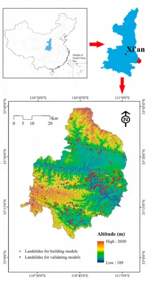
Sh an g n an C ounty, Sh aan xi P ro vin ce, C hin a (Figu re 1) reg u larly su ffers a g reat d eal o f d am age from lan d slid es, so w as selected as a su itable site for ev alu atin g lan d slid e su scep tib ility m od els. The altitude in the area ranges from 189 to 2050 m above sea level (a.s.l.), and the area and m axim um slope angle are approxim ately 2307 km 2 and 65°, respectively. The average tem perature for the w hole county is 14.6 °C , ranging betw een 11.1 and 15.0 °C for various regions. The spatial distribution of air tem perature is affected by altitude. The tem perature is low in the northern and southern m ountainous areas, and high in the central and D anjiang R iver areas.
Topographically, Sh an g n an C ou n ty is a m o u n tain o u s terrain in the E astern Q in lin g M oun tains. The altitud es in the northern and southw estern areas are higher than in the m idd le and southeastern
areas. The stud y area can be divided into three geom orphological units: (I) H illy areas w ith altitudes belo w 5 0 0 m and a relativ e h eig h t d ifference o f less th an 2 0 0 m ; (II) lo w -relief areas w ith altitu d es betw een 500 and 1000 m and a relative height difference betw een 200 and 500 m; and (III) m id-m ountain zones w ith altitudes above 1000 m and a relative height difference greater than 500 m.
110°30'0"E 110°45'0"E 111°0'0"E
Figure 1. Location of the study area and landslide inventory.
L an d slid e in v en to ry is the b asis for LSM . R eliab le and accu rate lan d slid e in v en to ry d ata are cru cial for L SM [51 ]. To en h an ce the reliab ility and accu racy of lan d slid e in v en to ry m ap s, a to tal of three techniques w ere used in the study: H istorical reports, in terp retation of aerial photographs, and exten siv e g lo b al p o sitio n in g sy stem (G PS) field su rveys. A cco rd in g to lan d slid e in v en to ry m ap s in the region, a total of 348 lan d slid es w ere id en tified (Figu re 1) . From these lo cation s, 244 (70% ) w ere rand om ly selerted for bu ild in g the m odels, and 104 (30%>) w ere used for valid ating m odels.
Appl. Sci. 2018, 8, 2540 4 of 19
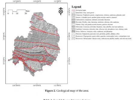
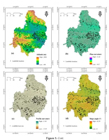
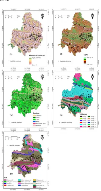
Fifteen factors (11 continuous a n d 4 categorical) were chosen and produced from the digital topographical m aps at a 1:50,000 scale, LANDSAT-8 satellite im ages w ith a spati al resolution of 30 m , the com pilation of geological m aps on a 1:200,000 scale, the com pilation of land use m aps on a 1:100,000 scale, and soil m aps on a 1:1,000,000 scale. T he list of the factors used in this study are show n in Table 1. A ltitude, p lan curvature, profile cu rvctu re, slope angle, slope aspect, topographic w etn ess index (TW I), stream pow er index (SPI), sedim ent transport index (STI), distance to roads, and distance to rivers factors w ere determ ined from topographical m aps. D istance to Rault and lithology factors w ere produced from the geological m aps. N orm alized difference vegetation index (NDVI) w as produced from tine* LANDSAT-8 satellite im ages. L and use and soil factors w ere extracted from land use and soil m aps, respectively. Finally, a 30 m pixel size w as choren for all the factor maRS (Figure 3 ).
Figure 2. Geological map of the area.
Table 1. Landslide conditioning factors.
Category Factors GIS Data Type Scale or Resolution
Topographic factors Altitude Plan curvature Profile curvature Slope angle Slope aspect TWI SPI STI ARC/INFO GRID ARC/INFO GRID ARC/INFO GRID ARC/INFO GRID ARC/INFO GRID ARC/INFO GRID ARC/INFO GRID ARC/INFO GRID
30 X 30 m 30 X 30 m 30 X 30 m 30 X 30 m 30 X 30 m 30 X 30 m 30 X 30 m 30 X 30 m Environmental factors Distance to rivers
Distance to roads NDVI Land use Soil ARC/INFO GRID ARC/INFO GRID ARC/INFO GRID ARC/INFO polygon coverage ARC/INFO polygon coverage
30 X 30 m 30 X 30 m 30 X 30 m 1:100,000 1:1,000,000 Geological factors Lithology
Distance to faults
ARC/INFO polygon coverage ARC/INFO GRID
110°45'0"E
1 1____ 1 iKm >
0 5 10 20 (^)
*
* '»
W*
V. • *. .••»••• f . " • •**
• * \ \
~ v \ . . • . • ' \ >
”.rv
H ? . . /
(c) Profile curvature
m High: 11.43
• Landslide locations
^ Low: -11.93
Appl. Sci. 2018, 8, 2540 6 of 19
Appl. Sci. 2018, 8, 2540 8 of 19
3. M odeling A p p roach es
3.1. Bagging
Bagging is based on the concepts of bootstrapping and aggregating, and is one of the m ost popular ensem ble algorithm s [53]. In bagging, the training set is random ly sam pled
n
tim es w ith replacem ent, prod ucingn
trainin g sets w ith sizes equal to the original train ing set [53].In this study, w e co n sid ered a learn in g set
C
co n sistin g o fn
in d ep en d en t o b serv atio n s [54,5 5 ]. H ere, th ey are lan d slid e co n d itio n in g factors, so w e hav eC = { (X
i,Yi
)
,i =
1 , 2 , . . . n}
. Firstly, setC
b(b
= 1,2, . . . , n) d en o tes the b-th bo o tstrap sam p le o f the train in g setC
o btain ed b y d raw in g w ith rep lacem en tn
elem en ts o f C. Secondly, co m p u te th e bo o tstrap p ed estim ato rg
* (■)
b y the plug-in principle:g
* (■) = h
n((
X * , Y *)
, . . .(
Xn,Y
* ))(■)
. Finally, repeat the above stepm
tim es, w here them
is o ften defined as 50 or 100, y ield in gg*
k(■ )(k =
1 , 2 , . . . ,m )
. So, th e b ag ged estim ato r ism
E g*k()
g
Bag ( 0 = i~Lm .In theory, the bagged estim ator is described as follow s:
■ ) = * [g * (■)], (1)
w here the theoretical quantity corresponds to m ^ ro and the finite num ber
m
in practice governs the accuracy of the M o n te C arlo approxim ation.3.2. Kernel Logistic Regression
K L R is a p o w erfu l and flexible d iscrim in ativ e m eth o d , w h ich p o ssesses th e ability to p rovid e the co n fid en ce o f class p red ictio n [56]. A co n v en tion al log istic regressio n m o d el w as constru cted in high-dim ensional feature space and proposed by a M ercer kernel [57]. G iven the labelled training data:
D
= { (x
i ,y
i) } ,i
= 1 ,x
i e X eR
d,y
i e [0,1], (2)w here
x
i is the landslide conditioning factor, andK
:X x X ^ R
evaluates the inner product betw een the im ages of input vectors in the featu re space.T h e k ern el fu nction used in this stu d y is the isotropic radial basis fu nction (RBF):
K
(x
,x
! ) = e{ ?Hx-x/ll } (3)T hen, a convention al logistic regression m od el w as constructed in the featu re space as follow s:
p
lo g
it { h
(x
)}
=f
(x
) +c
, lo git
(p
) = log-——
—
, (4) 1 -p
w here (w,c) are the optim al m odel param eters.
4. R esults
4.1. Selection o f Landslide Conditioning Factors
In the presen t study, the least su p p o rt v ecto r m achin e (LSSV M ) [59] and average m erit (AM ) criteria [60,61] w ere app lied for the selection of the proper cond itioning factors as w ell as determ ining their im portance. The results show ed that all selected conditioning factors have an im pact on landslide occurrences in the Shangnan area, China. A liitude has the greatest im pact on landslide occurrences (AM = 14.5), follow ed b y distance tea road (A M = 23), diatance (o fau lt (A M = 12.°), lith o log y (A M = 12.6), land u se (A M = 11.1), distance; to river (A M = 10.5), STI (A M = 8.5), SP I (A M = 7.2), TW9 (A M = 6.7), profile curvature (AM = (5.1), slcp e angle (AM = 4.7), N D V I (AM = 4.15), soil (AM = 3.7), plan curvature (A M = 3.2), and slope asp ect (A M = 1.5) (Fipure p). Thu s, the m o st effectiv e con d itio n in g factors are altiOude, d fotance to raad , and disdance tea fault, w h ich aligno w ith results o f Tien Bui et al. [a3] and C hen et al. [319]. As all 15 landslide conditioning f9ctord positively contribute in the study area, all w ere used for fu rth eran sly sis.
Slope aspect Plan curvature Soil NDVI Slope angle Profile curvature TWI SPI STI Distance to rivers
Landuse Lithology Distance to faults Distance to roads Altitude
0 2 4 6 8 10 12 14 16
AM
Figure 4. Importance of conditioning factors.
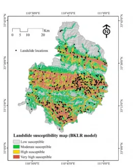
4.2. Generation o f Landslide Susceptibility Maps
The final m odel results produce a landslide susceptibility m ap, w hich can be used as an effective tool for m an ag in g fu tu rs lan d slid e occurrences. T h ese m aps w ere constructed follo w in g these; steps. Firstly, the w hole study aeea w as converted to pixels using ArcG IS (Esri, CA , USA) softw are. Then, ihe train in g d ataset w as trainee. in a train in g p h ase, th en all p ixels w ere pred icted biased on the learned trend arid aesigned in u niq u e in d exes. N ext, all in d exes w ere classified based on the n atu ral breaks (Jenks) classificatio n scliom e [62,63]. Finally, these in d exes for th e th ree m o d els w ere cla stified into fou r classes: Low, m od erate, hig h , and very h i° h su sceptibility (Figures 5- 7). T he dercentage o . area covered try law, m oderate, high, and -very high susceptibility for the three m odels is show n in Figure 8 . For she B L R K m o d el, these areas hre 28.94% , 26.86% , 23.58% , and 20.63% , respectively. Four the K L R m od el. they Eire 17.68% , 32.03% , 32.53% , and 17.77% , respectively, and for SV M , the area percentages are 24.59% , 28.29% , e2 .50% , arid 19.62% , respectively.
3.2 ■ 3.7
Appl. Sci. 2018, 8, 2540 10 of 19
Figure 5. Landslide susceptibility map using the bagging-based two-class kerne l logistic regression (BKLR) model.
110°30'0"E 110°45'0"E 1 1 1 W E
Figure 7. Landslide susceptibility map using the support vector machines (SVM) model.
35.00
30.00 % J 25.00
I 20.00
® 15.00 s
g 10.00
5.00
0.00
■ BKLR
■ KLR
■ SVM
Low
28.94
17.68
24.59
Moderate
26.86
32.03
28.29
High
23.58
32.53
27.50
Very High
20.63
17.77
19.62
Figure 8. Distribution of landslide susceptibility zones.
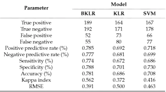
4.3. Validation and Comparison of Models
Appl. Sci. 2018, 8, 2540 12 of 19
as lan d slid es, follo w ed b y SV M (0.686) an d K L R (0.672). B K L R had the h ig h est sp ecificity (0.788), follo w ed b y SV M (0.730) an d K L R (0.701). T h e B K L R m o d el classified 78.8% o f the n o n -lan d slid e lo cation s as n o n -lan d slid e classes. In term s o f accuracy, B K L R (0.781) w as su p erio r to SV M (0.708) and K LR (0.686). The BK LR m odel correctly classified 78.1% of the landslide and non-landslide pixels. In term s o f th e k ap p a in d ex, th e B K L R m o d el p erfo rm ed b e st (0.56), d em o n stratin g a su bstan tial to alm ost perfect agreem ent betw een prediction and observation, follow ed by SVM (0.41) and K LR (0.37). In term s o f the R M S E , B K L R h ad th e lo w est v alu e (0.31), follo w ed b y SV M (0.46) and K L R (0.50). G enerally, the B K L R m o d el, in term s o f all criteria, had th e b e st p erfo rm an ce in th e train in g phase, follow ed by SV M and KLR. The m odel evaluation in testing phase is show n in Table 3 . G enerally, the results show that BK LR , for both the trainin g and testing phases, perform ed the best, follow ed by the SV M and K LR m odels.
Table 2. Model performance comparison.
Parameter Model
BKLR KLR SVM
True positive 189 164 167
True negative 192 171 178
False positive 52 73 66
False negative 55 80 77
Positive predictive rate (%) 0.785 0.692 0.718 Negative predictive rate (%) 0.777 0.681 0.699
Sensitivity (%) 0.774 0.672 0.686
Specificity (%) 0.788 0.701 0.730
Accuracy (%) 0.781 0.686 0.708
Kappa index 0.562 0.372 0.416
RMSE 0.391 0.500 0.463
Table 3. Model validation.
Model Parameter
BKLR KLR SVM
True positive 67 56 62
True negative 90 76 90
False positive 14 28 14
False negative 37 48 42
Positive predictive rate (%) 0.826 0.667 0.814 Negative predictive rate (%) 0.708 0.614 0.680
Sensitivity (%) 0.644 0.542 0.593
Specificity (%) 0.864 0.729 0.864
Accuracy (%) 0.754 0.636 0.729
Kappa index 0.509 0.371 0.458
RMSE 0.439 0.506 0.470
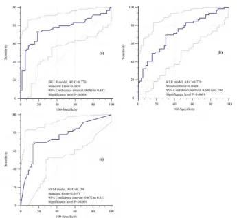
Figure 9. Receiver operating characteristics (ROC) curves using the training dataset: (a) BKLR model, (b) KLR mo del, (c) SVM model.
Appl. Sci. 2018, 8, 2540 14 of 19
5. D iscussion
In this study, a novel bagging-based kernel logistic regression classification m odel w as proposed and applied for landslide susceptibility in Shangnan County, C hina. A total of 1 5 cond itioning factors w ere selected to create lan d slid e su scep tibility m o d els. T h e results show ed th at all the con d itio n in g factors had positive effects on landslide occurrence w ith different degrees of influence according to the A M v alu es based on L S S V M . A ltitu de, d istan ce to road s, and d istan ce to fau lts received the h ig h est A M v alu es, in ag reem en t w ith som e ex istin g reports [33,3 9 ]. A ltitu d e co m p reh en siv e con trols the local clim ate an d v eg etatio n d ev elo p m en t ch aracteristics [69], w h ich are related to the stab ility of slop es [ 70] . T h e A M v alu es fo r lithology, lan d u se, and d istan ce to rivers w ere b o th larger th an 10.0 as w ell. G enerally, th e stren g th o f a slop e b o d y v aries w ith d ifferen t lith o lo g y types [71]. F or areas w ith d ifferent land u se types, the corresp ond in g p h ysical and m echanical characteristics o f soils and rocks have notable differences [44]. R ivers can affect the hydro-geological conditions of slopes, w hich have strong connections w ith landslide occurrence [39]. O n the basis of relevant studies, STI, SPI, and TW I are u su ally in d isp en sab le co n d itio n in g factors in lan d slid e su scep tibility m o d elin g [23,66,72]. C u rvatu re, w h ich inclu d es profile cu rv atu re and p lan cu rvatu re, can reflect th e g eo m etric featu res o f slop es, an d the g eo m etric featu res can in flu en ce stress d istrib u tio n o f slop es [30,73]. F or slope angle, landslides gen erally occur in a certain range of slope angles, and slope angle is another critical conditioning factor [45] . The relationships betw een the other factors (NDVI, soil type, and slope aspect) and landslide occurrence have also been analyzed b y other researchers [74- 76].
To evaluate the perform ance of BKLR, KLR, and SVM m odels in landslide susceptibility m apping, R O C cu rves an d A U C v alu es o f v ariou s m o d els w ere obtain ed . T h e results co n firm ed th at all three m o d els w ere reason able for lan d slid e su sceptibility m ap p in g , and th e B K L R m o d el h ad the b est accuracy and prediction capacity. T he results also verified that bagging is an effective tool to increase the p red ictio n accu racy o f a sing le classifier b y creatin g an en sem b le learn in g classifier [77]. In this case, b ag g in g im p roved the stability o f the co n v en tion al K L R m o d el u sin g th e R BF kern el fun ction. The sensitivity of a single classifier to noise in a dataset could be decreased by bootstrap sam pling, so the varian ce of the classification m odel decreases correspon dingly [53].
T here are som e ad van tag es o f the B K L R : T his m o d el can p ro d u ce class p ro babilities, w hereas SV M is a d eterm in istic classifier. B K L R is also reco m m en d ed for future ap p licatio n to the study area w ith n ew tech n iqu es and m o d els or n ew h ybrid m o d els, an d the m o st ap p rop riate m o d el can be selected for fu tu re m od elin g . A s a p ractical reco m m en d atio n , w e p ro p o se th a t th e g o v ern m en t an d d ecisio n m ak ers m u st co m p lete an ex ten siv e field survey to confirm the resu lts o f th e p resen t study (and esp ecially the areas th at h av e h ig h an d v ery h ig h su sceptibility to lan d slid e occurrences). A cco rd in g to case study ch aracteristics, policy m ak ers can m ak e an in fo rm ed d ecisio n for future
landslide hazard m itigation.
6. C onclusions
T h e m ain aim o f this study w as to co n stru ct a n ew h yb rid m o d el u sin g b ag g in g -b ased kern el lo g istic regressio n (K L R ), called B K L R , fo r spatial p red ictio n o f lan d slid es in th e Sh an g n an area in C hina. T h e p red ictio n cap ability o f 15 co n d itio n in g factors w as assessed for the m o d elin g process u sing the LSSV M algorithm . T he perform an ce of the new hybrid m odel w as evaluated u sing several popu lar statistical m easures, inclu ding PPR , N PR , sensitivity, specificity, the kappa index, and RM SE. A lan d slid e su scep tibility m ap w as prod uced u sin g the h ybrid m o d el and it w as com p ared w ith the su sceptibility m aps produced b y the single K LR m od el and SV M algorithm .
Author Contributions: W.C., H.S., S.Z., K.K., A.S., K.C., B.T., P., T.Z., L.Z., H.C., J.M., Y.C., X.W., R.L., and B.B.A. contributed equally to the work. T.Z., L.Z., H.C., J.M., Y.C., X.W., and R.L. collected field data and conducted the landslide mapping and analysis. W.C., H.S., S.Z., K.K., A.S., and K.C. wrote the manuscript. W.C., H.S., K.K., A.S., K.C., B.T., P., and B.B.A. provided critical comments in planning this paper and edited the manuscript. All the authors discussed the results and edited the manuscript.
Acknowledgments: The authors wish to thank Lufei Yang (Northwest Nonferrous Survey and Engineering Company) for useful information provided. This study has received financial support from the National Natural Science Foundation of China (Grant Nos. 41807192, 41602359, 41602212), China Postdoctoral Science Foundation (Grant Nos. 2018T111084, 2017M613168), Project funded by Shaanxi Province Postdoctoral Science Foundation (Grant No. 2017BSHYDZZ07), the Doctoral Scientific Research Foundation of Xi'an University of Science and Technology (Grant No. 2013QDJ038), and the Universiti Teknologi Malaysia (UTM) based on a Research University Grant (Q.J130000.2527.17H84).
Conflicts of Interest: No potential conflict of interest is reported by the authors.
R eferences
1. Malamud, B.D.; Turcotte, D.L.; Guzzetti, F.; Reichenbach, P. Landslide inventories and their statistical properties. Earth Surf. Process. Landf. 2004,29, 687-711. [CrossRef]
2. Glade, T. The Temporal and Spatial Occurrence o f Rainstorm-Triggered Landslide Events in New Zealand: An
Investigation into the Frequency, Magnitude and Characteristics o f Landslide Events and Their Relationship with Climatic and Terrain Characteristics: A Thesis Submitted [to the] Victoria University o f Wellington in Fulfilment of
the Requirements for the Degree of Doctor of Philosophy in Physical Geography; Victoria University of Wellington:
Kelburn, New Zealand, 1997.
3. Mohammady, M.; Pourghasemi, H.R.; Pradhan, B. Landslide susceptibility mapping at golestan province, iran: A comparison between frequency ratio, dempster-shafer, and weights-of-evidence models. J. Asian
Earth Sci. 2012, 61, 221-236. [CrossRef]
4. Sassa, K.; Canuti, P. Landslides-Disaster Risk Reduction; Springer Science & Business Media: Berlin, Germany, 2008.
5. Quan-min, X.; Xiang, B.; Yuan-you, X. Systematic analysis of risk evaluation of landslide hazard. Rock Soil
Mech. 2005, 26, 71-74.
6. Pradhan, B.; Lee, S. Delineation of landslide hazard areas on penang island, malaysia, by using frequency ratio, logistic regression, and artificial neural network models. Environ. Earth Sci. 2010, 60, 1037-1054. [CrossRef]
7. Tien Bui, D.; Lofman, O.; Revhaug, I.; Dick, O. Landslide susceptibility analysis in the hoa binh province of vietnam using statistical index and logistic regression. Nat. Hazards 2011, 5 9 ,1413-1444.
8. Aditian, A.; Kubota, T.; Shinohara, Y. Comparison of GIS-based landslide susceptibility models using frequency ratio, logistic regression, and artificial neural network in a tertiary region of ambon, Indonesia.
Geomorphology 2018, 3 1 8 ,101-111. [CrossRef]
9. Ding, Q.; Chen, W.; Hong, H. Application of frequency ratio, weights of evidence and evidential belief function models in landslide susceptibility mapping. Geocarto Int. 2017, 32, 619-639. [CrossRef]
10. Zhang, Z.; Yang, F.; Chen, H.; Wu, Y.; Li, T.; Li, W.; Wang, Q.; Liu, P. GIS-based landslide susceptibility analysis using frequency ratio and evidential belief function models. Environ. Earth Sci. 2016, 75, 1-12. [CrossRef]
11. Tien Bui, D.; Shahabi, H.; Shirzadi, A.; Chapi, K.; Alizadeh, M.; Chen, W.; Mohammadi, A.; Ahmad, B.; Panahi, M.; Hong, H.; et al. Landslide detection and susceptibility mapping by airsar data using support vector machine and index of entropy models in cameron highlands, malaysia. Remote Sens. 2018,1 0 ,1527. [CrossRef]
12. Chen, W.; Pourghasemi, H.R.; Naghibi, S.A. A comparative study of landslide susceptibility maps produced using support vector machine with different kernel functions and entropy data mining models in China.
Bull. Eng. Geol. Environ. 2018, 77, 647-664. [CrossRef]
13. Tsangaratos, P.; Ilia, I.; Hong, H.; Chen, W.; Xu, C. Applying information theory and gis-based quantitative methods to produce landslide susceptibility maps in nancheng county, China. Landslides 2017,1 4 ,1091-1111. [CrossRef]
Appl. Sci. 2018, 8, 2540 16 of 19
15. Devkota, K.C.; Regmi, A.D.; Pourghasemi, H.R.; Yoshida, K.; Pradhan, B.; Ryu, I.C.; Dhital, M.R.; Althuwaynee, O.F. Landslide susceptibility mapping using certainty factor, index of entropy and logistic regression models in gis and their comparison at mugling-narayanghat road section in nepal himalaya.
Nat. Hazards 2013, 6 5 ,135-165. [CrossRef]
16. Rosian, G.; Csaba, H.; KingaOlga, R.; Botan, C.; Gavrila, I.G. Assessing landslide vulnerability using bivariate statistical analysis and the frequency ratio model. Case study: Transylvanian plain (Romania). Z. Geomorphol. 2016, 60, 359-371. [CrossRef]
17. Felidsimo, A.M.; Cuartero, A.; Remondo, J.; Quiros, E. Mapping landslide susceptibility with logistic regression, multiple adaptive regression splines, classification and regression trees, and maximum entropy methods: A comparative study. Landslides 2013,1 0 ,175-189. [CrossRef]
18. Shirzadi, A.; Chapi, K.; Shahabi, H.; Solaimani, K.; Kavian, A.; Ahmad, B.B. Rock fall susceptibility assessment along a mountainous road: An evaluation of bivariate statistic, analytical hierarchy process and frequency ratio. Environ. Earth Sci. 2017, 7 6 ,152. [CrossRef]
19. Pourghasemi, H.R.; Rossi, M. Landslide susceptibility modeling in a landslide prone area in mazandarn province, north of Iran: A comparison between GLM, GAM, MARS, and M-AHP methods. Theor. Appl.
Climatol. 2016,130, 609-633. [CrossRef]
20. Nicu, I.C. Application of analytic hierarchy process, frequency ratio, and statistical index to landslide susceptibility: An approach to endangered cultural heritage. Environ. Earth Sci. 2018, 77, 79. [CrossRef] 21. Razavizadeh, S.; Solaimani, K.; Massironi, M.; Kavian, A. Mapping landslide susceptibility with frequency
ratio, statistical index, and weights of evidence models: A case study in northern Iran. Environ. Earth Sci. 2017, 76, 499. [CrossRef]
22. Althuwaynee, O.F.; Pradhan, B.; Park, H.-J.; Lee, J.H. A novel ensemble bivariate statistical evidential belief function with knowledge-based analytical hierarchy process and multivariate statistical logistic regression for landslide susceptibility mapping. Catena 2014,114, 21-36. [CrossRef]
23. Pourghasemi, H.R.; Kerle, N. Random forests and evidential belief function-based landslide susceptibility assessment in western mazandaran province, iran. Environ. Earth Sci. 2016, 7 5 ,185. [CrossRef]
24. Prefac, Z.; Dumitru, S.; Chendes, V.; Sirodoev, I.; Cracu, G. Assessment of landslide susceptibility using the certainty factor model: Rascuta catchment (curvature subcarpathians) case study. Carpath. J. Earth Environ.
Sci. 2016,11,617-626.
25. Chen, W.; Xie, X.; Peng, J.; Shahabi, H.; Hong, H.; Tien Bui, D.; Duan, Z.; Li, S.; Zhu, A.-X. Gis-based landslide susceptibility evaluation using a novel hybrid integration approach of bivariate statistical based random forest method. CATENA 2018,1 6 4 ,135-149. [CrossRef]
26. Chen, W.; Pourghasemi, H.R.; Zhao, Z. A gis-based comparative study of dempster-shafer, logistic regression and artificial neural network models for landslide susceptibility mapping. Geocarto Int. 2017, 32, 367-385. [CrossRef]
27. Erfanian, M.; Farajollahi, H.; Souri, M.; Shirzadi, A. Comparing the efficiency of weight of evidence, logistic regression and frequency ratio methods for mapping groundwater spring potential in ghelgazi watershed, kordestan province of iran. JWSS-Isfahan Univ. Technol. 2016, 20, 59-72. [CrossRef]
28. Shahabi, H.; Hashim, M.; Ahmad, B.B. Remote sensing and gis-based landslide susceptibility mapping using frequency ratio, logistic regression, and fuzzy logic methods at the central zab basin, Iran. Environ. Earth Sci. 2015, 73, 8647-8668. [CrossRef]
29. Mandal, S.; Mandal, K. Modeling and mapping landslide susceptibility zones using gis based multivariate binary logistic regression (lr) model in the rorachu river basin of eastern Sikkim Himalaya, India. Model. Earth
Syst. Environ. 2018, 4, 69-88. [CrossRef]
30. Pradhan, B. A comparative study on the predictive ability of the decision tree, support vector machine and neuro-fuzzy models in landslide susceptibility mapping using GIS. Comput. Geosci. 2013, 51, 350-365. [CrossRef]
31. Oh, H.J.; Pradhan, B. Application of a neuro-fuzzy model to landslide-susceptibility mapping for shallow landslides in a tropical hilly area. Comput. Geosci. 2011, 37,1264-1276. [CrossRef]
32. Chen, W.; Panahi, M.; Tsangaratos, P.; Shahabi, H.; Ilia, I.; Panahi, S.; Li, S.; Jaafari, A.; Ahmad, B.B. Applying population-based evolutionary algorithms and a neuro-fuzzy system for modeling landslide susceptibility.
33. Tien Bui, D.; Tuan, T.A.; Klempe, H.; Pradhan, B.; Revhaug, I. Spatial prediction models for shallow landslide hazards: A comparative assessment of the efficacy of support vector machines, artificial neural networks, kernel logistic regression, and logistic model tree. Landslides 2016,13, 361-378. [CrossRef]
34. Ngadisih Bhandary, N.P.; Yatabe, R.; Dahal, R.K. Logistic Regression and Artificial Neural Network Models for Mapping of Regional-Scale Landslide Susceptibility in Volcanic Mountains of West Java (Indonesia). In Proceedings of the International Symposium on Earthhazard and Disaster Mitigation: The Symposium on Earthquake and Related Geohazard Research for Disaster Risk Reduction, Bandung, Indonesia, 11-12 October 2016; p. 060001.
35. Chen, W.; Shahabi, H.; Shirzadi, A.; Hong, H.; Akgun, A.; Tian, Y.; Liu, J.; Zhu, A.-X.; Li, S. Novel hybrid artificial intelligence approach of bivariate statistical-methods-based kernel logistic regression classifier for landslide susceptibility modeling. Bull. Eng. Geol. Environ. 2018,1-23. [CrossRef]
36. Zabihi, M.; Pourghasemi, H.R.; Pourtaghi, Z.S.; Behzadfar, M. Gis-based multivariate adaptive regression spline and random forest models for groundwater potential mapping in iran. Environ. Earth Sci. 2016, 75, 1-19. [CrossRef]
37. Nefeslioglu, H.; Sezer, E.; Gokceoglu, C.; Bozkir, A.; Duman, T. Assessment of landslide susceptibility by decision trees in the metropolitan area of istanbul, turkey. Math. Probl. Eng. 2010,2010. [CrossRef]
38. Hong, H.; Pradhan, B.; Xu, C.; Bui, D.T. Spatial prediction of landslide hazard at the yihuang area (China) using two-class kernel logistic regression, alternating decision tree and support vector machines. Catena 2015,133, 266-281. [CrossRef]
39. Chen, W.; Xie, X.; Wang, J.; Pradhan, B.; Hong, H.; Tien Bui, D.; Duan, Z.; Ma, J. A comparative study of logistic model tree, random forest, and classification and regression tree models for spatial prediction of landslide susceptibility. CATENA 2017,1 51,147-160. [CrossRef]
40. Chen, W.; Xie, X.; Peng, J.; Wang, J.; Duan, Z.; Hong, H. Gis-based landslide susceptibility modelling: A comparative assessment of kernel logistic regression, naive-bayes tree, and alternating decision tree models.
Geomat. Nat. Hazards Risk 2017, 8, 950-973. [CrossRef]
41. Huang, Y.; Zhao, L. Review on landslide susceptibility mapping using support vector machines. Catena 2018,
165, 520-529. [CrossRef]
42. Lin, G.F.; Chang, M.J.; Huang, Y.C.; Ho, J.Y. Assessment of susceptibility to rainfall-induced landslides using improved self-organizing linear output map, support vector machine, and logistic regression. Eng. Geol. 2017, 224, 62-74. [CrossRef]
43. Youssef, A.M.; Pourghasemi, H.R.; Pourtaghi, Z.S.; Al-Katheeri, M.M. Landslide susceptibility mapping using random forest, boosted regression tree, classification and regression tree, and general linear models and comparison of their performance at Wadi Tayyah Basin, Asir Region, Saudi Arabia. Landslides 2016,13, 839-856. [CrossRef]
44. Chen, W.; Pourghasemi, H.R.; Panahi, M.; Kornejady, A.; Wang, J.; Xie, X.; Cao, S. Spatial prediction of landslide susceptibility using an adaptive neuro-fuzzy inference system combined with frequency ratio, generalized additive model, and support vector machine techniques. Geomorphology 2017, 297, 69-85. [CrossRef] 45. Nasiri Aghdam, I.; Varzandeh, M.H.M.; Pradhan, B. Landslide susceptibility mapping using an ensemble
statistical index (Wi) and adaptive neuro-fuzzy inference system (ANFIS) model at alborz mountains (Iran).
Environ. Earth Sci. 2016, 75, 553. [CrossRef]
46. Tien Bui, D.; Pradhan, B.; Lofman, O.; Revhaug, I.; Dick, O.B. Landslide susceptibility mapping at hoa binh province (Vietnam) using an adaptive neuro-fuzzy inference system and GIS. Comput. Geosci. 2012, 45, 199-211. [CrossRef]
47. Pham, B.T.; Bui, D.T.; Pourghasemi, H.R.; Indra, P.; Dholakia, M. Landslide susceptibility assesssment in the uttarakhand area (India) using GIS: A comparison study of prediction capability of naive bayes, multilayer perceptron neural networks, and functional trees methods. Theor. Appl. Climatol. 2015,1-19. [CrossRef] 48. Tsangaratos, P.; Ilia, I. Comparison of a logistic regression and naive bayes classifier in landslide susceptibility
assessments: The influence of models complexity and training dataset size. CATENA 2016,1 4 5 ,164-179. [CrossRef]
Appl. Sci. 2018, 8, 2540 18 of 19
50. Chen, W.; Shirzadi, A.; Shahabi, H.; Ahmad, B.B.; Zhang, S.; Hong, H.; Zhang, N. A novel hybrid artificial intelligence approach based on the rotation forest ensemble and naive bayes tree classifiers for a landslide susceptibility assessment in langao county, china. Geomat. Nat. Hazards Risk 2017, 8,1955-1977. [CrossRef] 51. Zhou, C.; Yin, K.; Cao, Y.; Ahmed, B.; Li, Y.; Catani, F.; Pourghasemi, H.R. Landslide susceptibility modeling applying machine learning methods: A case study from longju in the three gorges reservoir area, China.
Comput. Geosci. 2018,112, 23-37. [CrossRef]
52. Suzen, M.L.; Kaya, B.S. Evaluation of environmental parameters in logistic regression models for landslide susceptibility mapping. Int. J. Digit. Earth 2012, 5, 338-355. [CrossRef]
53. Breiman, L. Bagging predictors. Mach. Learn. 1996, 2 4 ,123-140. [CrossRef]
54. Mbogning, C.; Broet, P. Bagging survival tree procedure for variable selection and prediction in the presence of nonsusceptible patients. BMC Bioinform. 2016,1 7 ,1-21. [CrossRef] [PubMed]
55. Buhlmann, P. Bagging, boosting and ensemble methods. In Handbook ofComputational Statistics; Springer: Berlin, Germany, 2012; pp. 985-1022.
56. Sugiyama, M.; Simm, J. A computationally-efficient alternative to kernel logistic regression. In Proceedings of the IEEE International Workshop on Machine Learning for Signal Processing, Tokyo, Japan, 29 August-1 September 2010; pp. 124-129.
57. Mercer, J. Functions of positive and negative type, and their connection with the theory of integral equations.
Philos. Trans. R. Soc. London Ser. A Contain. Pap. A Math. Phys. Character 1909, 209, 415-446. [CrossRef]
58. Chen, W.; Panahi, M.; Pourghasemi, H.R. Performance evaluation of GIS-based new ensemble data mining techniques of adaptive neuro-fuzzy inference system (ANFIS) with genetic algorithm (GA), differential evolution (DE), and particle swarm optimization (PSO) for landslide spatial modelling. CATENA 2017,157, 310-324. [CrossRef]
59. Isabelle, G.; Elisseeff, A. An introduction to variable and feature selection. J. Mach. Learn. Res. 2003, 3, 1157-1182.
60. Witten, I.H.; Frank, E.; Mark, A.H. Data Mining: Practical Machine Learning Tools and Techniques, 3rd ed.; Morgan kaufmann: Burlington, MA, USA, 2011.
61. Chen, W.; Li, H.; Hou, E.; Wang, S.; Wang, G.; Panahi, M.; Li, T.; Peng, T.; Guo, C.; Niu, C.; et al. Gis-based groundwater potential analysis using novel ensemble weights-of-evidence with logistic regression and functional tree models. Sci. Total Environ. 2018, 634, 853-867. [CrossRef]
62. Pourghasemi, H.R.; Rahmati, O. Prediction of the landslide susceptibility: Which algorithm, which precision?
CATENA 2018,1 62,177-192. [CrossRef]
63. Pham, B.T.; Prakash, I.; Bui, D.T. Spatial prediction of landslides using a hybrid machine learning approach based on random subspace and classification and regression trees. Geomorphology 2018,303,256-270. [CrossRef] 64. Chung, C.-J.F.; Fabbri, A.G. Validation of spatial prediction models for landslide hazard mapping.
Nat. Hazards 2003, 30, 451-472. [CrossRef]
65. Chen, W.; Zhang, S.; Li, R.; Shahabi, H. Performance evaluation of the gis-based data mining techniques of best-first decision tree, random forest, and naive bayes tree for landslide susceptibility modeling. Sci. Total
Environ. 2018, 644,1006-1018. [CrossRef]
66. Chen, W.; Yan, X.; Zhao, Z.; Hong, H.; Bui, D.T.; Pradhan, B. Spatial prediction of landslide susceptibility using data mining-based kernel logistic regression, naive bayes and rbfnetwork models for the long county area (China). Bull. Eng. Geol. Environ. 2018,1-20. [CrossRef]
67. Chen, W.; Shahabi, H.; Shirzadi, A.; Li, T.; Guo, C.; Hong, H.; Li, W.; Pan, D.; Hui, J.; Ma, M.; et al. A novel ensemble approach of bivariate statistical-based logistic model tree classifier for landslide susceptibility assessment. Geocarto Int. 2018, 33,1398-1420. [CrossRef]
68. Yesilnacar, E. The Application of Computational Intelligence to Landslide Susceptibility Mapping in Turkey. Ph.D. Thesis, Department of Geomatics, University of Melbourne, Victoria, Australia, 2005; p. 423.
69. Gruber, S.; Haeberli, W. Permafrost in steep bedrock slopes and its temperature-related destabilization following climate change. J. Geophys. Res. Earth Surf. 2007,112. [CrossRef]
70. Buma, J.; Dehn, M. A method for predicting the impact of climate change on slope stability. Environ. Geol. 1998, 35,190-196. [CrossRef]
72. Chen, W.; Peng, J.; Hong, H.; Shahabi, H.; Pradhan, B.; Liu, J.; Zhu, A.X.; Pei, X.; Duan, Z. Landslide susceptibility modelling using gis-based machine learning techniques for chongren county, Jiangxi province, China. Sci. Total Environ. 2018, 6 26,1121-1135. [CrossRef] [PubMed]
73. Ayalew, L.; Yamagishi, H.; Ugawa, N. Landslide susceptibility mapping using GIS-based weighted linear combination, the case in tsugawa area of agano river, Niigata prefecture, Japan. Landslides 2004,1, 73-81. [CrossRef]
74. Sasaki, Y. Shallow Landslide Process and Hazard Mapping Using a Soil Strength Probe; Engineering Geology for Society and Territory—Volume 2; Lollino, G., Giordan, D., Crosta, G.B., Corominas, J., Azzam, R., Wasowski, J., Sciarra, N., Eds.; Springer International Publishing: Cham, French, 2015; pp. 957-960.
75. Magliulo, P.; Di Lisio, A.; Russo, F.; Zelano, A. Geomorphology and landslide susceptibility assessment using gis and bivariate statistics: A case study in southern italy. Nat. Hazards 2008, 4 7 ,411-435. [CrossRef] 76. Gokceoglu, C. Discussion on "combining landslide susceptibility maps obtained from frequency ratio,
logistic regression, and artificial neural network models using aster images and gis" by choi et al. (2012), engineering geology, 124,12-23. Eng. Geol. 2012,129-130,104-105. [CrossRef]
77. Pham, B.T.; Prakash, I. A novel hybrid model of bagging-based naive bayes trees for landslide susceptibility assessment. Bull. Eng. Geol. Environ. 2017. [CrossRef]