ISSN (e): 2250-3021, ISSN (p): 2278-8719
Vol. 09, Issue 5 (May. 2019), ||S (XI) || PP 07-11
Mobile Mapping Application for E-land Information
Meghana Madhukar Gayakwad
1
, Dr. Sachin Choudhari
2
, Monali Gulhane
3
1(Dept.of Computer Science & Engineering, Jhulelal Institute of Technology, RTMNU, Nagpur, India)
2(Asst.Professor, Dept.of Computer Science & Engineering Jhulelal Institute of Technology, RTMNU, Nagpur, India,)
Abstract:
Mobile phone has permanently transformed the socio economic strata of the society. Mobile
phone has allowed a lot of application to be developed and implemented for the benefit of the society.
The smart phones have opened a plethora of opportunities and one such area is the land office which
caters to provide and regulate the details of land, its sale and purchase etc. A mobile application can
be developed which allows the smart phone user to obtain the land record and the details of the
owner’s that to at the touch of the finger Mobile gadget with android operating system has a
location-based feature that is useful to provide information displayed in a map.E-Land mobile application
which aims to simplify the Land Office and the community in obtaining more accurate land area
information. Utilization of GPS technology on mobile has a function to get location in performing a
survey to determine the coordinate points of a ground area. The applications were made aiming to
help the Land Officer and the public to know the location of the land digitally. The utilization of GPS
technology is used to determine the coordinate points of the boundary in the form of latitude and
longitude accordance with the existing situation in the field. The advantage of mapping digital land
certificates is not only to know the land site, but also get the information contained in the map and
make map-making is much cheaper because they do not need to use a lot of tools, maintenance, in
addition to the storage media practically do not need more space.
Keywords:
Android, Global position system (GPS), Google Maps. Mobile E-land application,
I.
Introduction
E-Governance facilities are being promoted by government throughout the country and have helped the citizens to be aware of their rights and have also helped them to take advantages of various facilities floated by the government. Integration of mobile technologies with e-governance scheme has been a game changer and had benefitted the common man like anything. Such a scheme has improved the effectiveness of the schemes and has helped the government to take forward the country in the right direction. In this work we intend to introduce the features, technologies and design of the Android mobile device application, E-Land for the customer (client) of Indian citizen and land agency. This paper discusses the development of a land certificate mapping application digitally by utilizing GPS technology in the Google map. By connecting the land site listed in the land certificate and Google map in this application, the Land Officer in the National Land Agency (NLA), can easily manage the land reform and the tenures can know precisely their land location and its borders. In addition the parties can see other information contained in the map, such as the history of the land ownership.
The overall advantages of the proposed mobile land app and server application will also be identified in comparison to the existing e-Governance system, giving a viable option to adopt and make use of integration of mobile technologies for providing e-Governance through this m app. With the proposed E-Land application, the Land Office / National Land Agency (BPN) can record land that has not been certified and the public can easily see the mapping of land certificates not manually, but digitally, facilitate the storage in the form of softcopy. The use of GPS technology on the smart phone will be used in determining the coordinate point of the boundary of the land location. Thus the dynamics of changes in land ownership administration can be more accurate and real-time.
This paper is based on the research results and application that has been developed, it can be concluded that: design of digital mapping of land certificates that have been made can be used as a supplement to the online maps owned by the national land agency. On the web application owned by the NLA in peta.bpn.go.id, no information about the ownership of the land and the online map shows only the relative position of the distribution of plots. The land officers of the NLA put the border sign of the land using stone materials or certain tree. These physical materials can be easily removed. Using coordinate boundary recognized by Google as proposed in this paper; make the border sign more stable. Admin (NLA) and user get information on a map in accordance with the information contained in the land certificate. [1]
In this paper, e-Land record information system has been designed and implemented with Google Map using Mobile Commerce by developing this mobile phone application. The mobile loanapp, a low-cost mobile phone application has been developed for the loan approval process of the bank. Google Map has been used to display the land record images while M-commerce transaction has been done by debiting the transaction charges (for transaction connectivity between the mobile, bank server and land server) from the client’s saving account. The development of this m-app, mobile loanapp results in simplification of the already cumbersome process of getting approval of the loan from the bank. Both the land server (official server of revenue department for providing land records) and the bank server (official server of the bank) work in interconnection to provide authentication personal information about the client (customer) and the relevant authentic land documents. The adoption of mobile Loan App will thus impact greatly the lives of common citizens, who will be the real benefactor in this case. The combination (integration) of all the advantages of the mobile technologies through this developed mobile Loan app combined with e-Governance and bank server facilities add greater dimension, scope and versatility to this developed mobile phone application (mobile Loan app). The local population that has remained reluctant to the use of various existing applications due to the cost of cell phone communication can find solace in using mobile Loan app. The low-cost design and implementation of mobile Loan app has thus saved time of the customers & provided more flexibility and efficiency to the bank and land administration services. The ease of use (no earlier experience required), its lightweight design and impressive features make this development an application worth of its use. The existence of Wi-Fi network combined with increased Internet usage in the recent times offer great opportunity to the state Government for the deployment of mobile loanapp. The development of this mobile application can be seen as an opportunity for its further seamless integration with cloud services for the future work. [2]
A research conducted by Rafialy and Sediyono related to the utilization of cloud computing in Google maps for mapping of land function shifting information in Minahasa Tenggara Regency results an application that can be used to monitor the land use. This application is useful in giving information about lands and land shifting function for food production, along with the factors that affect agricultural production which are depicted in a digital map by utilizing Google maps and Google satellite combined with cloud computing services. [3]
This work has been motivated by some previous work on the use of mobile technologies for the development of mobile applications (m-apps) for real-time projects involved in e-Governance initiatives and for various other real-time application scenarios around the world. From the previous work we get the idea for mapping the land using Android App and showing it on Google map for better access for third parties especially for government agency for land development. The need and importance of the implementation of location based services in Android, providing the clients with services that originate from the geographical location of user’s mobile device has been emphasized by Ch. R. Rani et al in their research work. The work on iOS application for university campus for iPhone, iPod touch and iPod has been done in order to simplify the livability of the university for students. [6]
This research conducted by Isnandar, evaluated the Accuracy of Utilization of Quick bird of Imagery in Google Earth for mapping land parcels. The results of this study are the images obtained by the method of screen, premium and mosaic on a relatively flat area has better accuracy, compared to the relatively hilly area. The premium method produces images with better accuracy than the screen and mosaic method. A research conducted by Rakhmat compares the result measurement of field boundary coordinates using CORS GPS with a method of RTK (Real Time Kinematic) and NTRIP (Networked with Transportation of RTCM via Internet Protocol) with the result measurement of field map coordinates via terrestrial measurement [13]
III.
Methodology
land and publish the certificate of owner ship provided by the land agency. The design of E-land application for land certificate mapping digitally. Position of land geography can be known using of GPS on mobile devices and coordinate points can be determined manually by moving pins which are available on Google maps. The mapping accuracy is confirmed through a field survey and can be matched with the existing land certificates.
The method used in this research is the method of research and development (R&D) with dynamic system approach, which is to know how big the achievements that have been achieved with the use of GPS in Google maps for mapping land certificates. R&D method is a research method that is specific needs analysis and to test the effectiveness of these products in order to function in society at large. The nature of the R&D can be seen in Fig. 1.
Fig.1. Steps of Research and Development Method (R&D)
3.1 Potential and Problems
The potential phase of the research is to identify problems faced by the Land Office and the wider community to obtain rapid and accurate land information. Such information can be provided through the help of GPS technology and mapping manipulation in Google Maps API V2 on android. With this, the public will also get clear information about the boundaries of the land that is around it and the area of coordinates.
3.2 Data Collection
The data collection stage in this research is by inputting coordinates manually, determining the coordinate marker on the application, to determine the coordinate points (latitude and longitude) of the land boundary owned by the land owner. In this data collection obtained at least 4 point coordinates, for example;
- The first point :-7.407243,110.519597; - The second point :-7.407312,110.519933; - The third point :-7.406312,110.520087; - The fourth point :-7.406255,110.519747.
3. 3 Product Design
The product design stage or mapping application of E- Land has two users, they are admin (land officer) and users (the tenures and other parties). The admin has full access rights to use the application, such as uploading a PDF file, input the ownership of the land, input the coordinates of the land borders, and look at the certificate and user settings. The application users have only the access right to his own land certificate that have been scanned by admin in the form of a PDF file and view the map of the location of the land in the form of digital certificates.
Design validation stage is the stage of assessing the product design or applications that aregenerated, which are customized to the needs of the Land Officer.
3.5 Design Revision
Stage design revisions can be done if the users or experts have been assessing the weaknesses of the product or the resulting application. If there are still weaknesses in the product or application, it is necessary to do revisions.
3.6 Product Trials
The pilot phase of land certificate mapping application products will be carried out on lands that have a valid certificate.
3.7 Product Revision
The product revision stage will be made after the testing phase of the product. By studying the weaknesses of the product or application that is generated, the researchers will conduct the revision phase of the product or application.
3.8 Utility Testing
The use of the pilot phase carried out at the location of the existing land certificate, with the design of applications that have been designed and the data is ready for the tests.
3.9 Product Revision
Product revision will be done again, if there are weaknesses in the products or applications that have been generated.
3.10 Production
This stage can be done if the product or application that is created has been tried and can be applied to real conditions and results to be developed.
IV.
Results And Discussion
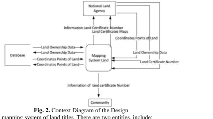
The application was designed using UML. The UML diagrams used are context diagrams and sequence diagrams. 2017 International conference on informatics and computing (ICIC).The purpose of this design is that the parties can grasp and understand the design to be built. The main aim is to provide e-land mapping application for India Citizen and Government which provides a robust architecture for locating the details of land owner. The applications will consist of and Web Application and Android Application which will allow user (citizen) to map their land or plot using Android Application and will also allow the land agency to use both web application and android app to maintain the records as well as issue the ownership certificate to the land owner.We intend to develop this application on Java Platform and all the data will be stored in my SQL database server. The access to the web application will only be provided to the land agency.
Fig. 2. Context Diagram of the Design.
4.1National Land Agency (NLA)
o Input from the system in the form of coordinate points of land, cadastral data input and no input the land certificates.
o Input from the system in the form of coordinate points of land, landowner data input and input number of land titles.
o Output to the success of the system in the form of ground coordinate data storage and data land holdings successfully stored in the database and update land certificates by certificate number of land owners.
4.2 Users
o Input to the system in the form of the certificate number of land owners. o Output of information systems in the form of land titles.
V.
Conclusion
In this work we expect to develop an, e-Land record information system which will be designed and implemented with Google Map using Java in form of a mobile phone application. We will be able to develop an android application E-Land capable of mapping the land. Google Map will be used to display the land record images while owner ship certificates will be published by land agency or Municipal Corporation through E-Land Web Application. We hope that the development of this E-E-Land will results in simplification of the already cumbersome process of getting land details for any kind of development. The Application will have two. main entities Admin (Land Agency or Municipal Corporation) and Citizen (land owner) and E-Land application will provide more practical use to both. As the coordinates are mapped through GPS and not manually it becomes quite easier for the admin to handle the system. It is expected that the system will be more accessible and responsive for the users.
References
[1]. Vikky, EkoSediyono and AdiSetiawan. “Analysis ofLand Area Caltulation Using of GPS Technology. “, Vol. 9, No. 1, Juli 2017[ 978-1-5090-1648-8/16/$31.00 ©2016 IEEE]
[2]. Kanwalvir Singh , Himanshu Aggarwal Journal of Software Engineering and Applications, 2013,
6,221228http://dx.doi.org/10.4236/jsea.2013.64027Published Online April 2013 (http://www.scirp.org/journal/jsea)
[3]. Rafialy, Leonardo and Sediyono, Eko; Setiawan, Andi, ”Pemanfaatan Cloud Computing Dalam GoogleMaps untuk Pemetaan,Informasi,AlihFungsi,LahandiKabupaten,MinahasaTenggara”, Seminar NasionalTeknologiInformasi, 2013, pp.52-58 [4]. Sendow, T.K and Longdong, Jefferson. “The Study Mapping ( city case study Manado )”. Scientific Journal Media Engineering
Vol.2, Numb.1, pp.35-46, March. 2012.
[5]. D. Bort, “Android Is Now Available as Open Source,”Android Open Source Project.
[6]. C. R. Rani, A. P. Kumar, D. Adarsh, K. K. Mohan and K.V. Kiran, “Location Based Services in Android,” International Journal of advances in Engineering & Technology, Vol. 3, No. 1, 2012, pp. 209-220.
[7]. W. Kowtanapanich, Y. Tanaboriboon and W. Chadbunchachal, “An Integration of Hand-Held Computers, GPS Devices and GIS to Improve the Efficiency of EMS Data System,” Journal of the Eastern Asia Society for Transportation Studies, Vol. 6, 2005, pp. 3551-3561.
[8]. Badanpertanahannasional. Accessedon Agustus 08, 2017..
[9]. BadanPertanahanNasional.http://www.bpn.go.id/BERITA/Berita-Pertanahan/tuntasdalam-10-tahun-66621, Accessed on October 23, 2017.
[10]. Sahoo, B. P. S and Rath, Satyajit,” Integrating GPS,GSM and Cellular Phone for Location Tracking and Monitoring,” Proceedings of the International Conference on Geospatial Technologies and Applications, IIT Bombay, Mumbai, India, 2012, February 26-29. [11]. Sugiyono, Metodepenelitiankuantitatif, kualitatifdan R & D. Bandung: Alfabeta., 2010.
[12]. Vikky, EkoSediyono and AdiSetiawan. “Using GPS and Google Maps for Mapping Digital Land Certificates.”, 2016 International Conference on Informatics and Computing (ICIC)
[13]. Isnandar, Andang, “Study the use of accuracy image quickbird in google earth to land parcels mapping” Bandung Institute of Technology. 2008.
[14]. Law No. 3 of 1997 on the Implementation of Government Number 24 Year 1997 on Land
Registration.http://www.bpn.go.id/DesktopModules/EasyDNNNews/DocumentDownload.ashx?portalid=0&moduleid=1671&articl eid=668 &documentid=701, accessed on may march 28, 2016.
[15]. Amelia, N.R and Akhbar; Arianingsih, Ida, 2015, “Pembuatan Peta Penutup Lahan Menggunakan Foto Udara yang Dibuat dengan Paramotor di Taman Nasional Lore Lindu (TNLL)” (The Development Of Land Cover Maps Using Aerial Photo of Loren Lindu National Park /NPLL)”, Warta Rimba Vol.3, Numb.3, pp.65-72, December. 2015.