Using The Gong Perdamaian Nusantara
Monument And Planetarium To Develop
Mathcitymap Tasks
Puguh Wahyu Prasetyo, Afit Istiandaru, Fariz Setyawan, Adi Nur Cahyono, Vita Istihapsari, Chistina Erlin Disasmita
Abstract: Gong Perdamaian Nusantara is a monument of the diversity of Indonesia located in Taman Pintar Park—an education tourism object in Yogyakarta, Indonesia, while the Planetarium is also located there as one of the science center. We bring the idea of making mathematics task about the monument in a digital application platform—the MathCityMap. We chose the monument because it could challenge the visitors—mostly children—to engage in a fun mathematical activity while appreciating the value of ―unity in diversity‖ at the monument. Furthermore, we also developed tasks installed on two objects that are pulley simulation and planetarium back door. This article aims to describe the development process and result of the task. This research is design research with the type of development studies refers to Plomp model. First, the preliminary stage was done to analyze the object, the related mathematics material, and the potential task. Second, the formative evaluation stage included the self-evaluation, expert review, one-to-one, and panel discussion. The task resulted has been installed well in the application of MathCityMap which can be accessed worldwide through the application store for Android.
Index Terms: Design research, Digital mathematics platform, Fun mathematical task, Gong Perdamaian Nusantara, Height measurement, MathCityMap, Taman Pintar Yogyakarta, Quadratic Function, Realistic Mathematics Education.
—————————— ——————————
1.
INTRODUCTION
MATHCITYMAP is a digital platform allowing individuals to engage with mathematics task in their surrounding landmark [1]. The idea of mathematics as human activities [2] often forgotten in the classroom since the learning only concern that mathematics is abstract [3]. Thus students could not feel the meaning of what they learn at school. Installing MathCityMap application at the mobile phone will enable the user to try some mathematics trails and challenged to solve realistic problems found in the designated object. In the application store, it is easy to find as the logo is illustrated in Fig. 1.
Fig. 1. The MathCityMap
MathCityMap offers an outdoor mathematics activity. Following a particular trail, an individual could find a challenge to solve a problem at the object within the trail. Thus, MathCityMap is useful to introduce cultural heritage, historical building, or unique landmark. Utilizing an interesting object around us could help the students having a better perception of mathematics. Moreover, it could also motivate the students to learn mathematics through outdoor activities, either in classroom group or with their family [4].
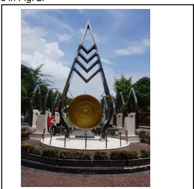
Every object in our surrounding could be mathematized. We are interested to use the object in the Taman Pintar, an education park in Yogyakarta, Indonesia. There are many interesting outdoor objects in the playground of Taman Pintar. Every object is usually aimed to inform some facts of science or deliver a message. One of the icons in the Taman Pintar Yogyakarta is the Gong Perdamaian Nusantara monument, as illustrated in Fig. 2.
Fig. 2. Gong Perdamaian Nusantara
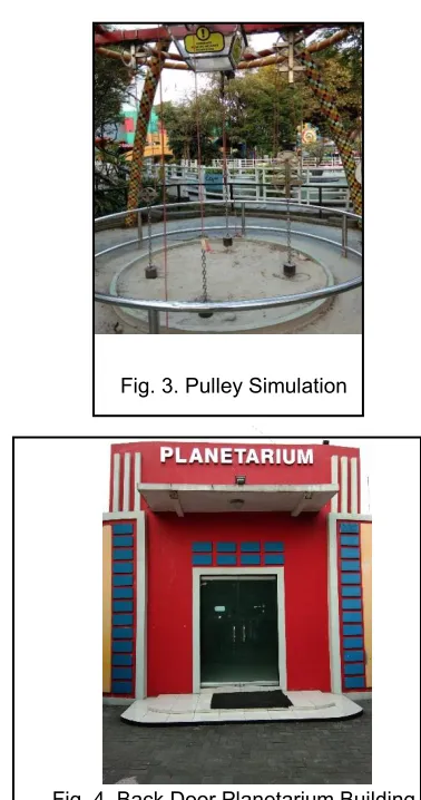
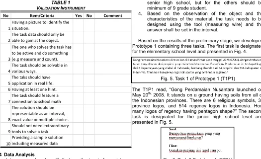
Gong Perdamaian Nusantara is a giant traditional Javanese music instrument installed in a high monument tower. On the Gong, there are 514 logos of regencies and 34 logos of provinces in Indonesia. There are also six symbols of religions recognized by the government. According to an interview with the organizer of Taman Pintar, the Gong delivers a message of unity, that Indonesia is a great country having various ethnics and religions. From the explanation above, we have plenty of reasons to select the Gong as the object for MathCityMap task. Furthermore, we also build tasks on the pulley simulation figured out in Fig 3 to express mathematical concept on rotation and also on the back door of ―planetarium‖ building illustrated in Fig 4 to express on the learning quadratic ————————————————
Afit Istiandaru is a lecturer in Mathematics Education Department of
Universitas Ahmad Dahlan, Yogyakarta, Indonesia. E-mail:
Puguh Wahyu Prasetyo is a lecturer in Mathematics Education Department of Universitas Ahmad Dahlan, Yogyakarta, Indonesia. E-mail: [email protected]
Fariz Setyawan is a lecturer in Mathematics Education Department of
Universitas Ahmad Dahlan, Yogyakarta, Indonesia. E-mail:
Dr. rer. nat. Adi Nur Cahyono is a lecturer and MathCityMap educator in Mathematics Department of Universitas Negeri Semarang, Semarang, Indonesia. Email: [email protected]
Vita Istihapsari is a lecturer in Mathematics Education Department of
Universitas Ahmad Dahlan, Yogyakarta, Indonesia. E-mail:
2 function.
Fig. 3. Pulley Simulation
Fig. 4. Back Door Planetarium Building
2
METHOD
2.1 Research Design
This research is design research with the type of development studies referring to Plomp model [5]. The stages were illustrated in Fig. 5.
Fig. 5. Cycles in design research
First, we conducted a preliminary stage which consists of the analysis of the object, material, and creating the task design. In the object analysis, we selected an object which has a meaningful message, famous, and easy to find. We also analyze the trend of the visitors of Taman Pintar Yogyakarta to assume the education level of the visitors. In the material analysis, we review the mathematics materials in elementary school and junior high school level. We used the regulation of
the Indonesian Ministry of Education and Culture number 24/2016 as the basis of selecting the potential topics for designated visitors [6]. After selecting the object, the level, and the material, we designed the tasks. Second, we proceeded to the formative evaluation which consists of developing a prototype, self-assessment, expert review, one-to-one, and panel discussion. Using the design resulted in the preliminary stage, we constructed a prototype of the task named Prototype 1. We discussed the Prototype 1 in the self-assessment step, reviewing it according to its relevancy with the material, the object, and the level. After that, we send the draft to an expert of a MathCityMap. The expert looked at the validity of the task according to the principles of the MathCityMap task. The criteria of the task is also available in the tutorial website of MathCityMap [7], they are: 1) uniqueness, 2) attendance, 3) activity, 4) multiple solutions, 5) reality, 6) handy tips, 7) school math and tags, 8) solution format, 9) tools and 10) sample solution. We used the results of the expert review to revise the Prototype 1 and then we invited three subjects to try the application. Further, the results of self-assessment, expert review, and one-to-one were discussed in the panel discussions. We conducted panel discussion twice, the first was conducted with the organizer of the Taman Pintar Park, and the second was conducted with the Regional Planning Body of the Government of Yogyakarta. The recommendation resulted in the panel discussion was followed up to revise the tasks and to produce the Prototype 2. This prototype is ready to be accessed by the public.
2.2 Participants
We involved some stakeholders in this research. First, the expert to validate the prototype is a MathCityMap educator. We also involved the organizer team of Taman Pintar Yogyakarta and the member of the Regional Planning Body of Yogyakarta Government. Also, we involved three pre-service mathematics teachers to involve in the process of one-to-one.
2.3 Data Collection Method and Instrument
TABLE1
VALIDATION INSTRUMENT
2.4 Data Analysis
The data were analyzed qualitatively as the inputs for revision of the prototype. We used source triangulation to confirm the validity of the data. For instance, the results of the self-assessment were compared to the results of the expert review. Also, the results of the panel discussion with the Taman Pintar organizer were compared to the results of the panel discussion with the government of Yogyakarta.
3 RESULTS
AND
DISCUSSION
At the preliminary stage, the results were as follows:
1. The first selected object is the Gong Perdamaian Nusantara. It has a message of unity in diversity of Indonesia. It also serves as the icon of the Taman Pintar Yogyakarta. Thus, it is observable. Moreover, the other objects are back door of Planetarium Building, Dinding Berdendang, and pulleys simulation.
2. Some potential material could be identified in the context of the gong. They are: estimating the height of the monument, measuring the diameter of the gong, calculating the surface area of the gong, and recognizing shapes in the logo of provinces at the gong. On the other hand, we could see the area of the back door of Planetarium Building as a quadratic function with 𝑥 as its width and 𝑥 + 𝑎 as its height, where 𝑎 is a positive real number. We can also challenge students by giving a task on the pulleys simulation. There are four kinds of pulleys installed on the playground in Taman Pintar Yogyakarta. The difference between four kinds of pulleys depend on the sum of pulleys. This condition motivated us to give the first challenge which the heaviest pulley is and what is the radius of its pulley.
3. The level of the targeted user for doing the Gong Perdamaian task may vary from elementary school to
senior high school, but for the others should be minimum of 9 grade student.
4. Based on the observation of the object and the characteristics of the material, the task needs to be designed using the tool (measuring wire) and the answer shall be set in the interval.
Based on the results of the preliminary stage, we developed Prototype 1 containing three tasks. The first task is designated for the elementary school level and presented in Fig. 4.
Fig. 5. Task 1 of Prototype 1 (T1P1)
The T1P1 read, ―Gong Perdamaian Nusantara launched on May 20th, 2008. It stands on a ground having soils from all of the Indonesian provinces. There are 6 religious symbols, 34 province logos, and 514 regency logos in Indonesia. How many logos of regency having pentagon shape?‖ The second task is designated for the junior high school level and presented in Fig. 5.
Fig. 6. Task 2 Prototype 1 (T2P1)
The T2P1 read, ―What is the area the circle-shaped gong?‖ Hint, ―Use the length of floor tiles.‖ The third task is designated for senior high school and presented in Fig. 6.
Fig. 7. Task 3 Prototype 1 (T3P1)
The T3P1 read, ―Gong Perdamaian Nusantara launched on May 20th, 2008. It stands on a ground having soils from all of the Indonesian provinces. There are 6 religious symbols, 34 province logos, and 514 regency logos in Indonesia. Estimate the height of the gong. Unit: cm.‖ Before we send the Prototype 1 to expert for validation, we evaluated the prototype through self-assessment. We found that the redaction of the task—especially for elementary school students—was too hard. It needs to be simplified such that it is understandable for elementary school level. Furthermore, we observed that the logos of regency in Indonesia are so many. The counting skills of the elementary school students probably have not reached the number or the height of the students could not reach the top of the gong when they observe to count. Thus, it needs to be revised by limiting to the logo of the provinces. It is in line with the opinions of some experts that children’s numeracy skills in age five to eight still in simple counting, base-10 simple arithmetic, and depend on the use of concrete object [8]. We revised it and produced the revised T1P1 as illustrated in Fig. 7.
No Item/Criteria Yes No Comment
1
Having a picture to identify the situation.
2
The task data should only be able to gain at the object.
3
The one who solves the task has to be active and do something (e.g measure and count).
4
The task should be solvable in various ways.
5
The taks should have application in real life. 6 Having at least one hint.
7
The task should feature a connection to school math
8
The solution should be representable as an interval, exact value or multiple choice.
9
Should not need extraordinary tools to solve a task.
10
4 Fig. 8. Revised-T1P1
On the other hand, the T1P2 read, ―Mengganti Pintu Kaca installed on the backdoor of Planetarium Building‖ can be seen in the Fig.9. Students were expected to measure the area of the backdoor.
Fig. 9. Installed-T1P3
Moreover, the T1P4 read, ―Katrol installed on pulley simulation, was designed to nine grade student. The challenge in this task was what the length of the radius of the heaviest pulley is. The appearance of this task is shown in the Fig. 10.
Fig. 10. Task on pulley simulation
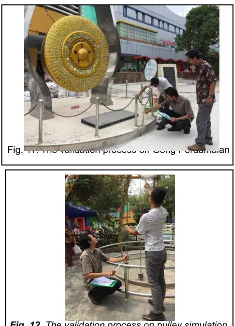
We proceeded to send the Prototype 1 which consist of T1P1, T2P1,T1P2, T2P2, T1P3, T3P2, and T1P4 to the expert for review and invited the validator to observe the object, as documented in Fig. 8, Fig. 9, and Fig. 10. The validation processes are describe in Fig. 11 and Fig. 12
Fig. 11. The validation process on Gong Perdamaian
Fig. 12. The validation process on pulley simulation
The results of the review can be presented below.
1. The tasks did not have application in real life. It should be modified at least one task to motivate the students to calculate a meaningful objective. The task of finding the gong area could be changed into the painting problem.
2. The task of province logos is good for elementary school. But considering that the user of the smartphone probably would not be under Grade 3, then it can be changed into the more challenging task, e.g. finding the percentage of proportion.
3. The tasks need to be completed with the ten criteria of a good task.
4. Measuring wire is allowed if there is no comparing object to measure.
5. Use GPS-assisted camera is preferable as it can assure the accuracy of the object location in the map. Contextual mathematics problems were proven to improve students’ mathematical cognition in many research [9]. The contextual problems also could motivate students to engage with mathematics task better than the non-contextual problems [10].
In the one-to-one trial, we only get feedback on the unclear picture and inaccurate position of the object. Thus, it needs to be adjusted.
Fig. 13. Panel discussion
The results of the panel discussions were:
1. The location of the object needs to be adjusted. 2. The task needs to be more fun, especially for the task
of senior high school.
3. Use the official description of the object.
Based on all of the recommendation, we revised the prototype and produced the Prototype 2. Prototype 2 has been uploaded into the system with complete information.
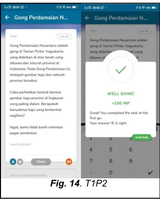
The first task is presented in Fig. 14.
Fig. 14. T1P2
Recall the T1P2 read, ―Gong Perdamaian Nusantara is a gong in Taman Pintar Yogyakarta, standing on the soil from all provinces in Indonesia. On the gong, there are logos of all the provinces. How many logos are in pentagon shape?‖. Further, we also add the percentage task, the redaction is changed into, ―What is the percentage of the number of logos having pentagon shape?‖. The students simply count the logos having pentagon shape—not necessarily regular—and then find the percentage. The second task has been revised using the contextual problem, as presented in Fig. 15.
Fig. 15. T2P2
6
Fig. 16. T3P2
The T3P2 read, ―Gong Perdamaian Nusantara monument is a gong in Taman Pintar Yogyakarta, standing on the soil from all provinces in Indonesia. Estimate the height of the monument. Unit: cm. Remember, you cannot trespass the boundary.‖ It also provides three hints. The Hint 1 said, ―Look at the height and the shadow of things around, they are always perpendicular.‖ The Hint 2 said, ―Make a comparison between the length of the shadow of the monument and the height of the monument, compared to the other thing.‖ The Hint 3 said, ―Use the similarity of triangle principle, that the ratio of the length of the shadow between two things will be the same with the ratio of the height between the two things.‖ With this installation, then Prototype 2 is ready to be accessed publicly.
4 SOFT-LAUNCHING
It follows from the development process that we already have some tasks installed on Gong Perdamaian Nusantara, Backdoor of Planetarium Building, and Pulley Simulation. In fact, Mathcitymap is an application which was motivated by mathematics trail. Hence, we combine some tasks into a route. The next agenda will be route testing. In this chance, the students who are available to be invited in the testing process is the student of Sekolah Menengah Pertama Negeri 12 Yogyakarta class 9D or simply SMP Negeri 12 Yogyakarta class 9D. Based on the interview process with the teacher, we got some informations about the class. One of them is the mathematics learning topics. The mathematics learning topics that were running when this research was on at the class 9D were quadratic equation, quadratic function, and transformation. Thus the route should be related to quadratic equation, quadratic function, and transformation. This condition motivates us to build the ―Mari Mengenal Terapan Fungsi Kuadrat dan rotasi‖ which contains two tasks asking the area of the backdoor of Planetarium Building and the radius of pulley on the pulley simulation. The installed route can be accessed on the Mathcitymap application shown in the Fig 17 below.
Fig 17. Mari Mengenal Terapan Fungsi Kuadrat dan Rotasi
Route
The students from class 9D of SMP Negeri 12 Yogyakarta were challenged to solve two task in this route. The testing was held on Friday, October 18, 2019 located on the playground area in Taman Pintar Yogyakarta. This agenda was designed to be the Soft-Launching of Mathcitymap route installed in Taman Pintar Yogyakarta. Furthermore, the testing agenda was also designed for the sixth meeting of Penugasan Dosen di Sekolah (PDS) program supported by Belmawa Ristekdikti. The first task of this route is solving the area of the backdoor of Planetarium Building. The students are divided into some groups such that every group consists of 2-3 students. The students tried to solve this task as illustrated in the Fig 20.
Fig. 20. The students on the first task
Fig. 21. The students on the second task
It follows from this testing experience the students were very excited to solve the route. The students said that this was the first time for them to use the Mathcitymap in the mathematics learning process.
5 CONCLUSION
The development process of the MathCityMap tasks follow the stages: 1) preliminary studies, including the analysis of the object, material, and level; 2) formative evaluation, including making Prototype 1, self-assessment, expert review, one-to-one, and panel discussion. Each stage results in a constructive revision for the task prototype. After finishing the tasks on the objects, the researcher should combine some tasks into a route. This combination may depend on the requirement of the mathematics learning for the students based on the what basic competence run on. The task and route are now accessible at the application and the website https://mathcitymap.eu/en/.
ACKNOWLEDGMENT
The authors wish to thank the Government of Yogyakarta (BAPPEDA Kota Yogyakarta) for the grant of research 04/SPK-UAD/Penelitian/II/2019 in 2019, the Belmawa Ristekdikti for the grant of Hibah PDS 2019, the SMP Negeri 12 Yogyakarta and Faculty of Education and Teacher Training, and LPPM UAD for giving the support in this research.
REFERENCES
[1] A.N. Cahyono, M. Ludwig and S. Maree, ―Designing mathematical outdoor tasks for the implementation of The MathCityMap-Project in Indonesia,‖ The Proceedings of the 7th ICMI-East Asia Regional Conference on Mathematics Education, pp. 151-158, 2015.
[2] M. van den Heuvel-Panhuizen and P. Drijvers, "Realistic mathematics education," Encyclopedia of mathematics education, S. Lerman, ed., Dordrecht: Springer Science+Business Media, pp. 521-525, 2014.
[3] I. Hidayah, Dwijanto and A. Istiandaru, "Manipulatives and Question Series for Elementary School Mathematics Teaching on Solid Geometry." International Journal of Instruction, vol. 11, no. 3, pp. 649-662, 2018.
[4] A.N. Cahyono and M. Ludwig, ―MathCityMap: Exploring Mathematics Around the City,‖ The Proceedings of the 13th International Congress on Mathematical Education, pp. 1-8, 2016.
[5] T. Plomp, ―Educational Design Research: An Introduction,‖
Educational Design Research, T. Plomp and N. Nieveen, eds., Enschede: Netherland Institute for Curriculum Development, pp. 10-51, 2013.
[6] MOEC, Peraturan Menteri Pendidikan dan Kebudayaan RI nomor 24 tahun 2016 tentang Kompetensi Inti dan Kompetensi Dasar pada Jenjang Pendidikan Dasar dan Menengah,
https://jdih.kemdikbud.go.id/arsip/Permendikbud_Tahun20 16_Nomor024.zip. 2016.
[7] MathCityMap, ―Criteria for a good task,‖ Tutorial, https://mathcitymap.eu/en/tutorials-en/. 2019.
[8] P. Aunio and P. Räsänen, "Core numerical skills for learning mathematics in children aged five to eight years– a working model for educators," European Early Childhood Education Research Journal, vol. 24, no. 5, pp. 684-704, 2016.
[9] T. Laurens, F.A. Batlolona, J.R. Batlolona and M. Leasa, "How does Realistic Mathematics Education (RME) improve students’ mathematics cognitive achievement." Eurasia Journal of Mathematics, Science and Technology Education, vol. 14, no. 2, pp. 569-578, 2018.
[10]C. Ekowati, "The Application of Contextual Approach in Learning Mathematics to Improve Students Motivation at SMPN 1 Kupang." International Education Studies, vol. 8, no. 8, pp. 81-86, 2015.