e-ISSN: 2278-067X, p-ISSN: 2278-800X, www.ijerd.com
Volume 11, Issue 05 (May 2015), PP.64-68
Vehicle Tracking and Remote Data Acquisition System using
Very High Frequency operated devices
Rupesh Punjani
1, Janvi Adiecha
2, R.K. Dave
3, Raju Adiecha
4, Manoj Pandya
5 1MJRP University, Rajasthan, India2Atimya College, Rajkot, India 3
Head, Govt. Initiatives, ITRA, New Delhi
4Rajen Electronics, Rajkot, India 5Project Manager, BISAG, Gandhinagar, India.
Abstract:- Amateur radio or Ham radio [1] is a provider of supplemental communications for disaster relief and disaster control agencies. Amateur radio can cover gamut of areas where conventional system fails to function. For example, existing vehicle tracking system works on GSM or GPRS based network which cannot function in remote geographical areas. This leads to construct alternate network using Amateur radio to establish audio communication and support in data acquisition.
Keywords:- VHF, Vehicle Tracking, GPS, Amateur Radio, HAM Radio
I.
INTRODUCTION
A vehicle tracking system [5] collects data of objects like latitude, longitude, altitude etc. for a comprehensive picture of vehicle locations. Modern vehicle tracking systems commonly use Global positioning System (GPS) or GLObal NAvigation Satellite System (GLONASS) technology for locating the vehicle. Vehicle tracking system uses Global System for Mobile Communications (GSM) [10] or General packet radio service (GPRS) [8] to transmit the acquired information to the central server. It works fine in urban region where the GSM network coverage is rich. However, there are certain outskirts areas which face poor GSM network coverage or some regions like coastal and boarder area suffer from unavailability of coverage. Boarder areas are geographically isolated area and it is most sensitive terrain of the nation. Hence it is necessary to establish communication in this region.
II.
RATIONALE
Use of Amateur Radio [1] that operates on VHF is used in the proposed system; helps to track the vehicles in remote places like desert, small interior villages where the GSM network is not available. Proposed model will also be useful in marine region. The GPS receiver is set to send location information to the server after every 10 seconds. Google maps services are used as Application programming Interface for web map services (WMS). System can locate the vehicle location on map and stores the route of the vehicle in the form of vertex points array in database which is useful to guide the vehicle when it goes astray. The system indicates with red colour and BEEP tone is generated by machine to draw the attention of the operator of the system. Once observed, operator can communicate with VHF sets and can guide with voice. The system is designed to perform in any kind of weather. Hence it can cover remote areas where GSM network based communication is not established.
Figure 1 shows that vehicle tracker gets its position using GPS by communicating satellites. This information is transmitted using Very High Frequency (VHF) [12] transceiver and sent to the workstation where VHF receiver gets this information and translated by database engine. In this system, Microsoft Access is used as a Relational Database Management System (RDBMS). Application manager can visualize this information on Google map using spatial dimension and Google API.
A. ELEMENTS OF THE SYSTEM
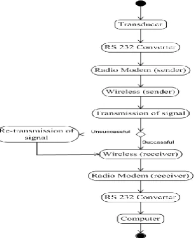
Transducer: A device which converts one form of energy into another form of energy. The data collected by sensors are attributed into meaningful information that can be interpreted and disseminated for further analysis.
RS232 Converter: It is a standard for serial communication transmission of data. It formally defines the signals connecting between a computer terminal and a modem [7].
Radio Modem: Radio modems transfer data wirelessly across a range of up to tens of kilometres. Using radio modems is a modern way to create Private Radio Networks (PRN) [9].
B. FUNCTIONALITYMECHANISM:
Send Data:
private static void SendSampleData() {
// Instantiate the communication // port with some basic settings SerialPort port = new SerialPort(
"COM1", 9600, Parity.None, 8, StopBits.One);
// Open the port for communications port.Open();
// Write a string
port.Write("Communication Established"); // Write a set of bytes
port.Write(new byte[] {0x0A, 0xE2, 0xFF}, 0, 3);
// Close the port port.Close(); }
Receive Data from Port
private SerialPortProgram() {
Console.WriteLine("Incoming Data:");
// Attach a method to be called when there // is data waiting in the port's buffer port.DataReceived += new
SerialDataReceivedEventHandler(port_DataReceived);
// Begin communications port.Open();
// Enter an application loop to keep this thread alive Application.Run();
}
private void port_DataReceived(object sender, SerialDataReceivedEventArgs e)
{
// Show all the incoming data in the port's buffer Console.WriteLine(port.ReadExisting()); }
Sending Files
Syntax for sending files in binary format is given here through the serial port. Of course, these are the bare essentials and as always, you should check to make sure the port is open first.
private static void SendTextFile( SerialPort port, string FileName)
{ port.Write(File.OpenText(FileName).ReadToEnd()); }
III.
SYSTEM
MECHANISM
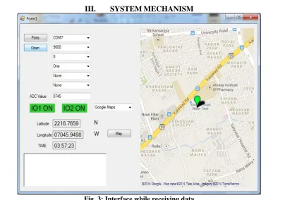
As shown in the above figure 3, when radio modem sends data, the label control is changed to GREEN color showing ON state.
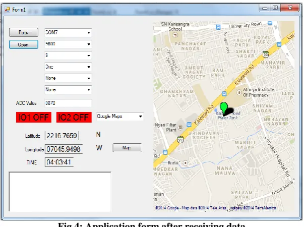
Fig 4: Application form after receiving data
As shown in the above figure 4, when application finishes receiving data, the label control is changed to RED colour showing OFF state. Once data is received by the system, it will project to Google map using Google API.
A. Advantage of the proposed system: Refusal to Interference:
Radio interference does not affect VHF nearly as much as HF. This proves especially beneficial for use in vehicles. Many police forces switched to VHF in the past, due to interference problems on HF, according to the Institute for Criminal Justice Education. The ICJE also indicates that VHF offers advantages in rural areas because it can more easily transmit long distances, when compared to UHF (Ultra High Frequency). However, it does not transmit so far that distant stations interfere with each other at night.
Superior Sound Reproduction:
VHF offers much better sound quality than HF bands like AM, shortwave and CB (Citizen's Band). This explains why broadcasters use it to transmit high-quality audio on FM radio and some television stations. It boosts intelligibility, which prevents misunderstandings and reduces the need to repeat oneself. The sound quality usually remains uniform at all hours.
Use of easy and economical Antenna:
VHF receivers generally use the least expensive, most portable antennas. For example, many FM and weather-band radios receive broadcasts with simple telescopic antennas that cost little to replace and retract into the receivers when not in use, among other advantages. UHF and HF receivers often use loops, long wires and other larger, more costly antennas. A radio operator can utilize the same VHF antenna for two-way communications and reception of the weather band. A combined radio/television may use the same antenna to pick up VHF TV stations and FM radio, but will require separate antennas for UHF and AM.
Marine Advantages:
IV.
CONCLUSIONS
Proposed system is very useful in marine, army and in disaster mitigation. It is necessary to explore the use of amateur radio as a provider of supplemental communications for disaster relief and disaster control agencies [1] [4]. Amateur radio operators, or hams, are skilled communicators willing and able to volunteer their time and equipment for emergencies. They also offer their skills and additional frequencies; thus, it makes sense to plan for and include them in disaster training and preparation and to use them when disaster strikes. Hams can work together with agencies to provide more effective communications during a disaster.
FUTURE SCOPE
There is always a scope for enhancements in any system, especially in the world of computers. The “Vehicle Tracking and Data Acquisition System” software and hardware can also be modified according to the future requirements like monitoring fuel levels, temperature, water level etc. That may lead to develop a comprehensive fleet management system for remote area like marine.
ACKNOWLEDGMENT
Authors would like to thanks T. P. Singh, Director, Bhaskaracharya Institute for Space Applications & Geo-informatics (Gandhinagar) and Dr. J. G. Pandya for constant encouragement to our research work.
REFERENCES
[1]. “HAM Radio”, Internet:
http://www.giar.org/index.php?file=webpages/webpage&id=what-is-ham-radio [5 May 2015]
[2]. Lynn Edwards, 1994, The utilization of amateur radio in disaster communications
[3]. “Role of Amateur Radio in Development Communication of Bangladesh”, Internet:
http://www.cimap.vt.edu/files/internet/Impression/ICT.pdf. [5 May 2015]
[4]. Ferguson, Richard, 1992, Packet Radio and Emergency Communications: Public Safety Enters the
Digital World. 73 Amateur Radio Today (October):42-45.
[5]. “Amateur Radio”, Internet:http://en.wikipedia.org/wiki/Amateur_radio [5 May 2015]
[6]. “Vehicle Tracking System”, Internet: http://en.wikipedia.org/wiki/Vehicle_tracking_system [10 May
2015]
[7]. “RS-232”, Internet: http://en.wikipedia.org/wiki/RS-232 [10 May 2015]
[8]. “General Packet Radio Service”, Internet: http://en.wikipedia.org/wiki/General_Packet_Radio_Service
[5 May 2015]
[9]. (2015) Radio Modem.[Online]. Available: http://en.wikipedia.org/wiki/Radio_modem
[10]. (2015) GSM. [Online]. Available: http://en.wikipedia.org/wiki/GSM
[11]. (2015) The Advantage of VHF. [Online]. Available:
http://www.ehow.com/info_8152526_advantages-vhf.html