ple of Stolpersteine
Timo Homburg
a∗, Klaus Böhm
a, Nicole Bruhn
a, Gregor Hubrich
aaMainz University Of Applied Sciences, Germany, {timo.homburg,klaus.boehm,nicole.bruhn}@hs-mainz.de
* Corresponding Author
Abstract: In this publication we introduce a linked data powered application which assists users to find so-called Stolpersteine, stones commemorating Jewish victims of the second world war. We show the feasibility of a dedicated location based service as an app using linked data resources and evaluate this approach against local data sources gathered by communities to find out if the current linked data environment can equally and/or sufficiently support an application in this knowledge domain.
Keywords:Stolperstein, linked data, app, location based service
1. Introduction
A common problem for the geospatial community is the evaluation of data sources in terms of fitness for use (Pôças et al., 2014), i.e. if the quality of the data sources is suf-ficient enough to support a certain use case. Data qual-ity is commonly measured using data qualqual-ity metrics cus-tomized for a specific use case (Homburg and Boochs, 2019) to quantify the fitness for use of the respective data set. We would like to test the fitness for use of (linked) open data sources representing Stolpersteine (Franke and Demnig, 2009), stones commemorating Jewish victims of the sec-ond world war in three similar-sized cities of Germany. We compare (linked) open data sources against our gold stan-dard data: Data sources which have been collected by local communities or historical societies (official data) dedicated to preserving the history of the city in which they operate. For our usecases in this publication, we traced those back to Wikipedia lists for which we are sure the local commu-nities maintain them. As we will describe in more detail in Section 2.3, many of the local communities provide means of accessing Stolperstein data such as maps or apps limited to their respective area of operation. The research ques-tion proposed in our publicaques-tion is to which extent (linked) open data sources can provide an equivalent fitness for use for the use case of an interested tourist/interested person compared to the data provided by the local communities. The results of this analysis can provide indications of the usefulness for a variety of possible linked data powered ap-plications such as city tour planning apps, geofencing apps or apps advising communities about possible maintenance work (e.g. polishing) of Stolpersteine and the methodol-ogy itself is useful to validate a variety of similar location based services in terms of their fitness for use. The paper is structured as follows: In Section 2 we discuss related work concerning geospatial linked open data, geospatial data quality assessment and existing Stolperstein applica-tions. In Section 3 we explain how we gather (linked) open data resources for our comparison case which we describe in Section 4. The results of our experiment are presented in Section 5 and discussed in Section 6 before we conclude the paper in Section 7.
1.1 Motivation
Stolpersteine have a significance as a cultural heritage mon-ument, as a destination for tourists interested in the Jewish history and for the local Jewish community to deal with the events of the past. Every local community has an inter-est to raise awareness of the bibliographies of the Jewish victims so that commemoration can be shared by a variety of people. A perfect way to raise awareness of Stolper-steine in the digital age is the development of digital tour guides and apps which may also be used for city market-ing. Such location based applications can only be useful if the data they provide is accurate and the geocoordinates are precise. However, not every local community has the knowledge and/or skills to develop their own apps or web-sites and would supposedly like a unified and simple solu-tion for Stolperstein data integrasolu-tion which could be used anywhere. With the emergence of OpenStreetMap (OSM) and linked data resources this possibility has now been es-tablished on the data provider side and poses the question if this linked data collection is sufficient to match the ex-pectations of the local community.
2. Related Work
In this section we discuss related work concerning the geospa-tial semantic web Section 2.1, geospageospa-tial data quality Sec-tion 2.2 and existing similar implementaSec-tions of Stolper-stein applications Section 2.3.
2.1 The Geospatial Semantic Web
also using their own vocabulary. For example: Wikidata implements a query to find elements in a bounding box or bounding circle, but does not implement Egenhofer topo-logical relations (Egenhofer and Franzosa, 1991) to com-pare relations between surface geometries. The availability of geospatial operations in the Semantic Web is despite the emergence of GeoSPARQL not sufficient e.g. for manip-ulations of raster and geometry manipmanip-ulations. Therefore, the geospatial semantic web is despite its advantages not often considered by the geospatial community. Obvious advantages of linked data include a unified classification access to interlinked datasets with potentially more use-ful information for the application case and the ability to do reasoning on the given linked data set to inference data previously not present in the data set. While reasoning is an interesting application and could, to an extent, be useful in the context of this publication, we focus and investigate if the advantage of data integration holds up against a man-ually created data set provided by supposed experts.
2.2 Geospatial Data Quality
Geospatial Data Quality can be broken down among oth-ers to Positional Accuracy (Guptill and Morrison, 2013), Completeness (Hecht et al., 2013) and Attribute Accura-cy/Completeness which are necessary to understand the contents of this publication. Positional Accuracy refers to how far a position of geometry deviates from the gold stan-dard. Completeness defines the availability of all geome-tries according to a reference data set (e.g a gold standard data set). In addition attribute completeness refers to the completeness of attributes and its values in relation to the reference data set. Attribute accuracy describes the cor-rectness of attribute values according to a gold standard to compare against. It can be measured syntactically and se-mantically using various distance metrics.
2.3 ExistingImplementationsofAppstohighlight
A variety of implementations and resources to show and find Stolpersteine can be found on the web. The city of Heilbronn1 created open data resources to share
Stolper-stein information as GeoJSON (Butler et al., 2016). A JavaScript Map project shows the Stolpersteine of the city of Bonn2building up on open data resources stored in the
OSM project. Some projects deal with the implementation of Android apps to view Stolpersteine of selected cities which are then integrated into the apps’ resources fold-ers, e.g. Stolpersteine-Android3. Other projects include
and define their own locally shared database schemas like the stolperstein-server project4. All of the aforementioned approaches have in common, that they are only regional solutions and not scaling up to a worldwide representation of Stolpersteine. Users has to download apps of their local city in order to get the service to find Stolpersteine nearby - a in the authors opinion unnecessary obstacle.
3. Modelling
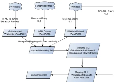
In this section we describe the implementation of our solu-tion following fig. 1.
1https://github.com/opendata-heilbronn/stolpersteine 2https://github.com/penpendede/stolperstein-bonn 3https://github.com/Stolpersteine/stolpersteine-android 4https://github.com/Stolpersteine/stolpersteine-server
Figure 1. Dataflow of the experimental setup
3.1 Data Access
At first, we introduce the data sources we use to access Stolpersteine in a worldwide context. The first data source is OpenStreetMap (Ramm and Topf, 2010), which we ac-cess using the Overpass API (Raifer et al., 2018). A Stolper-stein in OSM is modeled using the tag/value pair memo-rial:type=stolperstein, which can be used to query steine within a defined bounding box. Usually, Stolper-steine are modelled as Point geometries (nodes in OSM), but in special occasions thresholds of Stolpersteine exist, so called "Stolperschwellen", in which case the geometry might be modeled as a way or relation in OSM. Therefore the query in Listing 1 queries all three geometry types in OSM. According to TagInfo memorial:type=stolperstein, OSM currently contains 20598 Stolpersteine worldwide.
Listing 1. Overpass API Query O.1: Querying Stolper-steine in a given bounding box
Stolpersteine [ o u t : j s o n ] [ t i m e o u t : 1 5 ] ; (
n o d e [" m e m o r i a l : t y p e "=" s t o l p e r s t e i n "] ( BBOX) ;
3 way [" m e m o r i a l : t y p e "=" s t o l p e r s t e i n "] ( BBOX) ; r e l a t i o n [" m e m o r i a l : t y p e "=" s t o l p e r s t e i n "] ( BBOX) ; )
5 ; o u t geom ;
The result of the Overpass API Query is a GeoJSON Fea-tureCollection of geometries and attributes which repre-sents the OSM geometry. The second data source, Wiki-data contains about 8000 Stolperstein representations5. Wiki-data can be queried using a bounding circle query to match Stolpersteine in Wikidata in the same area. This query is highlighted in Listing 2
Listing 2. SPARQL Query S.1: Querying Stolpersteine (Q26703203)in a given bounding circle of 30m diameter (here with sample coordinates)
1 SELECT ? i t e m ? i t e m L a b e l ? l o c a t i o n ? r e l ? r e l L a b e l
? v a l ? v a l L a b e l ? p i c ? monument WHERE{ ? i t e m wdt : P31 wd : Q26703203 .
3 ? i t e m wdt : P18 ? p i c . ? i t e m wdt : P1684 ? monument .
SERVICE w i k i b a s e : a r o u n d {
5 ? i t e m wdt : P625 ? l o c a t i o n .
bd : s e r v i c e P a r a m w i k i b a s e : c e n t e r " P o i n t ( 8 . 1 2 , 5 0 ) "^^ geo : w k t L i t e r a l .
7 bd : s e r v i c e P a r a m w i k i b a s e : r a d i u s " 30 ". }
? i t e m ? r e l l ? v a l . ? r e l w i k i b a s e : d i r e c t C l a i m ? r e l l .
9 SERVICE w i k i b a s e :l a b e l { bd : s e r v i c e P a r a m
w i k i b a s e : l a n g u a g e " en ". } }
The result of a Wikidata query can be given as a JSON object which we use for further processing.
3.2 Equivalent Geometry Matching
Obviously, two geometry sets have been queried, one OSM data set and one Wikidata data set. As both queries have been executed in the same area and (hopefully) depict the same objects, it is to be expected to find a lot of equivalent geometries which need to be matched in order to combine or compare their attributes. OSM geometries can be inter-linked to Wikidata instances using theOSM wikidata tag and a Wikidata ID as a value. According to TagInfo6this
tag has not yet been added to a lot of geometries, yet the amount of geometries annotated with Wikidata IDs is in-creasing steadily, also, but not exclusively due to the avail-ability of linking tools such as OSMWikidataLink7. As for our test areas, we found that an increasing amount of Stolpersteine depending on the city are interlinked to Wiki-data - a potential result of the WikiWiki-data Stolpersteine work-ing group. Official data has been matched to the OSM and Wikidata representations using two matching criteria:
• The geoposition using a bounding box query of 30m radius
• The name of the person to which the Stolperstein is dedicated
The second step is especially important because Stolper-steine are often co-located in front a building, as they com-monly depict a whole family which used to live at the re-spective place. As a result we end up with a maximum of three different representations per Stolperstein (OSM, Wikidata, official data)
3.3 Equivalent Attribute Matching
An OSM feature consists of a geometry and a list of tag/-value combinations. The Wikidata community collects tag and tag/value equivalences of Wikidata classes and Wiki-data instances using the WikiWiki-data relationwdt:P1282 (OSM tag or key). Using the query in Listing 3, it is possible to get a list of equivalent tags and tag/value combinations which can be used to match equivalent attributes between OSM and Wikidata. This list cannot be considered as ex-haustive, but is usually quite comprehensive, especially with common tags and tag/value pairs.
Listing 3. SPARQL Query S.2: Detecting Wikidata/OSM Equivalences as Mapping M.1
1 SELECT DISTINCT ? w d c l a s s ? w d c l a s s L a b e l ? osm
WHERE { ? w d c l a s s wdt : P1282 ? osm . SERVICE w i k i b a s e :l a b e l { bd : s e r v i c e P a r a m
w i k i b a s e : l a n g u a g e " en " }}
For official data, the kinds of attributes are usually limited and equivalences in Wikidata and OSM can be manually mapped (cf. Listing 4).
6https://taginfo.openstreetmap.org/search?q=wikidata 7https://osm.wikidata.link/
Listing 4. Mapping M.2: Official - OSM - Wikidata
v a r e q u i v s ={
2 " A d r e s s e ": {" osm ":" m e m o r i a l : a d d r ","wd":" P969 "} , " S t a n d o r t ": {" osm ":" m e m o r i a l : a d d r ","wd":" P969 "} ,
4 " Name ": {" osm ":" name ","wd":" r d f : l a b e l "}}
After matching equivalent geometries and attributes the re-sult can be displayed on a map8 as shown in Figure 2.
Differences between the respective data sets can be high-lighted in different colors to get an idea which equivalences and possible mismatches exists between the different data sources. The location based service developed in this
re-Figure 2. Comparison Screen build upon the mappings generated from Listing 3 and a custom mapping to official data shown in Listing 4: Green items represent a matching, orange item values represent a non-matching value, orange tag names represent that an equivalence is known in one of the other knowledge bases SPARQL Query to detect Wiki-data/OSM Equivalences
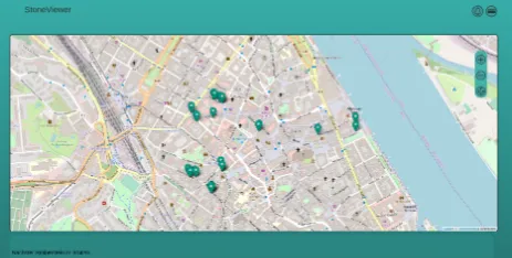
search work - the progressive web appStoneViewer9 - is
depicted in fig. 3. It allows users to navigate to Stolperstein monuments in their vicinity and to provide the information which has been provided to the app using the Wikidata and OSM Overpass API Queries. Yet our App can only be as good as the provided data feeding the application in-terface. The further part of this publication will therefore try to examine if our web application based on OSM and Wikidata data can achieve a comparable data quality score in comparison to the supposedly better manually created gold standard data set.
4. Experimental Setup
We investigate the quality of open data Stolperstein rep-resentations in three cities of Germany: Aschaffenburg, Mainz and Wiesbaden. The cities have been chosen be-cause they are similar-sized, in direct proximity, state or regional capitals and therefore chances of an active map-per and Wikidata community are very high. Initial analy-sis yielded a considerably large presence of Wikidata ob-jects and interlinkings in Wiesbaden and Mainz and a
non-8https://i3mainz.github.io/stolperstein
Figure 3. StoneViewer as a progressive web application to show Stolpersteine and to show information about Stolper-steine nearby
existent representation of Wikidata annotations in Aschaf-fenburg. In order to investigate quality of data we firstly need to define data quality criteria to investigate using data quality metrics. An obvious task to investigate is the com-pleteness of the data set. One expectation could be that the local community would add Stolpersteine regularly, for ex-ample when they attend the deployment ceremonies of new Stolpersteine in their city. Ideally, their list should be the most complete one. The next criteria we would like to look at is the amount of facts which have been provided by the respective data sources. How many facts are provided by each data source? How many facts match the gold stan-dard/official data? How many facts deviate and can they be categorized? How many and which facts can only be found in one of the three data sources?
While the previous questions may sound reasonable, the answers may be misleading in terms of the structure and aim of the data sets. Official data is commonly subject to only include data which is relevant to the description of the history depicted by the Stolperstein, i.e. information about people and not e.g. the material of the stone. One might ar-gue that the material of the actual Stolperstein, the initiator of the project Gunter Demnig and the fact that it is a monu-ment can be considered common knowledge among people familiar with the subject and add no additional value to the description of a Stolperstein. An image of the respective Stolperstein might instead equally add value to OSM, of-ficial data and Wikidata. Therefore a distinction of "valu-able attributes" and common attributes will be made in the evaluation. The last criteria to investigate is the average as well as min/max distance between the given coordinates (or centroids in case of thresholds) between OSM, Wiki-data and official Wiki-data sets.
4.1 Requirement Profile
In the last section we have introduced the quality crite-ria we would like to evaluate. In this section we describe which outcomes of data quality are relevant for the previ-ously described application case of a tourist and/or inter-ested person in Stolpersteine, i.e. represent the fitness for use. For this purpose we follow (Homburg and Boochs, 2019) to define a requirement profile to define a good/ac-ceptable Stolperstein representation as defined in Table 1.
In our opinion a Stolperstein description is only of use if the distance between the Stolperstein geocoordinates is sufficiently small. We assume that a deviance more than 10m from a Stolperstein geocoordinate to the gold
stan-Criteria Threshold Priority Crucial? Attribute Completeness >=80% 1 No Distance from official data <=10m 2 No
Number of mismatches <=2 2 No
Missing Name 1 2 Yes
Missing Coordinate 1 2 Yes
Missing Address 1 2 No
Table 1. Requirement profile depicting the requirements of a well-represented Stolperstein set with given thresh-old values and priority assignments (1-4) whereas 1 is the highest priority
dard (official data) depicts a situation in which the Stolper-stein will not be found by the average tourist. In addition, there are some crucial elements making a Stolperstein de-scription useful. Firstly, the name of the victim should be present in the dataset. Without, it may prove difficult to match the data given by the app to the stone in reality, es-pecially if many Stolpersteine exist next to each other. Sec-ondly, a street address can be of use which in combination with a geocoordinate usually allows the unique identifica-tion of at least a group of Stolpersteine if the name is not present.
5. Results
This section presents the results of our comparison in terms of completeness, positional accuracy, valuable attributes and common conflicts.
5.1 Completeness
At first we measured the completeness of Stolpersteine in the respective areas. As can be observed in Table 2, with
City OSM Wikidata Official Aschaffenburg 93 (87%) 0 (0%) 107
Mainz 48 (21%) 21 (9%) 228 Wiesbaden 129 (20%) 22 (3%) 652
Table 2. Completeness Of Stolpersteine
the exception of Aschaffenburg, the completeness of Stolper-steine in OSM is just a fraction of the Stolperstein data gathered by the local communities displayed in official data. We theorized that in Wiesbaden and Mainz this might be due to a preference of OSM users to map features in city centers, as they provide a natural area of interest. (see Fig-ure 4) We therefore repeated the completeness analysis for the areas of city centers in Table 3 giving a better coverage result of more than 50% for those areas.
City OSM Wikidata Official Aschaffenburg 47 (100%) 0 (0%) 47
Mainz 48 (75%) 21 (32%) 64 Wiesbaden 112 (57%) 15 (8%) 195
Table 3. City Center Completeness of Stolpersteine
5.2 Valuable Attributes
Figure 4. Coverage of Stolpersteine in Mainz: Orange icons indicate that a linking to Wikidata or OSM is present. Blue icons indicate official data. Linkings exclusively exist in the city centre.
City OSM Wikidata Combined
Aschaffenburg 80% 0% 80%
Mainz 50% 70% 65%
Wiesbaden 70% 70% 80%
Table 4. Completeness of attributes compared to the gold standard. If items are annotated in Wikidata and/or OSM, this table shows the coverage percentage of valuable at-tributes vs. the gold standard
is represented. In fact, only one attribute is consistently missing, the time of deployment. Images of the Stolper-stein are annotated 80% of the time, all other attributes are present in 100% of the cases in which an equivalent Stolperstein could be found in OSM. In Mainz, we can ob-serve a coverage of 50% of official data attributes in OSM. The most prominent attributes in OSM are the name and the inscription of the Stolperstein. Information in Wiki-data, despite annotated on far fewer Stolpersteine typically matches 70% of attributes in the gold standard, only miss-ing the donator and the inception date. This pattern repeats in Wiesbaden, with a higher OSM completeness of street addresses.
Additional attributes in OSM and Wikidata
In addition, about 20% of OSM annotated Stolpersteine provide an attributewheelchairindicating that the Stolper-stein can be approached by people with certain disabilities. While this attribute is not present in the official data it cer-tainly provides an extra value to the end user. In addition, for some Stolpersteine the date of birth and date of death of the commemorated person was added as an attribute. In Wikidata we found a lot of attributes we would not con-sider as valuable for our assessment.material used (P186) describes the material used to build the Stolperstein which is always brass. In addition we find information about the creatorGunter Demnig (Q195796), which also is the same for every Stolperstein. Sometimes thecountry (P17)is an-notated, which might be considered valuable, but could also be inferred from the GPS coordinates.
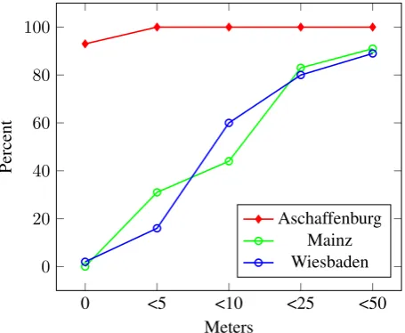
5.3 Positional Accuracy
Figure 5 shows the distances between OSM coordinates and official data coordinates for Stolpersteine with equiv-alences in OSM/Wikidata. In Aschaffenburg, we can ob-serve a high correlation of the coordinates which leads us
to believe that either the local community also contributes to OSM or that OSM contributors chose data of the local community to enrich the map. Mainz and Wiesbaden
ex-0 <5 <10 <25 <50 0
20 40 60 80 100
Meters
Percent
Aschaffenburg Mainz Wiesbaden
Figure 5. Stolperstein distances in Aschaffenburg, Mainz and Wiesbaden. In Aschaffenburg, distances to official data are negligible possibly due to the adoption of offi-cial coordinates in OSM. In Wiesbaden and Mainz more than 80% of all recorded Stolpersteine can be found in the vicinity of 25m
hibit a very similar behavior concerning the positional ac-curacy. Between 40% and 50% of Stolpersteine have been mapped within a distance of 10m, but more than 80% have been mapped within a distance of 25m to the official data set. Concerning why geocoordinates deviate we found a variety of possible reasons.
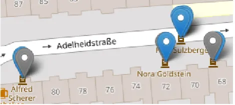
No precise GPS positional knowledge
Figure 6 shows that a mapper might not necessarily know the exact position of the Stolperstein but annotates accord-ing to the street address. Figure 6 shows, that a Stolperstein may be located at the same street address but the distance to the official data coordinate could exceed 30m in certain situations.
Semantic mistakes
A few mistakes yielding distances of greater than 1km, originated in the fact that coordinates had been copied from another Stolperstein in the vicinity, therefore again point-ing to annotation mistakes in the (linked) open data set. Also, the name of the person which is commemorated might have been annotated wrongly, yielding distances of greater than 1km using our data mapping algorithm.
Mapping of groups
Figure 6. Distance of official geocoordinate and OSM geo-coordinate in front of the same house. Here, the exact Stolperstein position might not be known to the OSM an-notator and a guess to where the Stolperstein is located was done based on the street address yielding in a distance of 30m between the coordinates.
Figure 7. Groups of Stolpersteine in Wiesbaden
Corner cases
Finally, in all three cities we found about 3% of Stolper-steine in the official dataset not depicting any coordinate or missing a name and one to three Stolpersteine being present in OSM but not in the official dataset. This ob-servation shows minor inconsistencies in both the official data set and possibly in OSM.
5.4 Attribute matches
We define an attribute match in two different ways. The first way is a syntactic match which occurs when an equiv-alent tag and the same value is found (denoted in green in Figure 9). The second attribute match is a semantic at-tribute match for which an equivalent tag and an equiv-alent value is found. If the equivequiv-alent value conveys the same semantic (or an extended) meaning compared to the official data we count it as a match. The semantic match was performed by a human annotator. Table 5 shows the differences between the matching types. Using semantic matching, additional information does still yield a match if non-additional information matches. This fact is
impor-Type Value1 Value2 Match
Syntactic Neugasse 8 Neugasse 10 False Syntactic Neugasse 8 Neugasse 8, Mainz False Syntactic Neugasse 8 Neugasse 8 True Semantic Neugasse 8 Neugasse 10 False Semantic Neugasse 8 Neugasse 8, Mainz True Semantic Neugasse 8 Neugasse 8 True
Table 5. Differences between semantic and syntactic matchings as applied in our evaluation
tant, as the schemas of three data sources OSM, Wikidata and Official data are not aligned.
5.5 Common conflicts
Figures 8 and 9 show typical conflicts which have been ob-served in the testing areas. Semantic conflicts occur when a misinterpretation of the human annotator happens. Syn-tactic conflicts either occur because of typing mistakes or because of a lack of convention on how to fill the respective attribute value. A distinction of how mistakes are treated in the evaluation is shown in Table 5. In Figure 8 it is
un-Figure 8. Semantic conflict: Despite a fitting address, the name of the person depicted on the Stolperstein does not match with the official dataset
clear if the name of the person depicted in the Stolperstein should be annotated with or without the maiden name of the person. In Wikidata for example, maiden names are classified separately (Q1376230), whereas OSM and the official data sources we investigated do not make such dis-tinctions.
Frequency Analysis
Figure 9. Writing convention: The name of the person de-picted by the Stolperstein may be written using the name including the maiden name or without it. Both representa-tions are correct and a matter of convention.
Figure 10. Edit distance examples: Typing mistake (low edit distance, no substring), incomplete name (substring and low edit distance), different name (no substring and high edit distance)
5.6 Overall quality of LOD Stolperstein data
Revisiting the requirements set in Section 4.1 defining well-represented Stolpersteine for the case of an interested tourist, we answer the question for which of the examined areas there is a sufficient amount of such Stolpersteine are repre-sentative. Table 7 shows the results of this analysis. In col-umn 1 and 2 we can see that only a fraction of the Stolper-steine which have been annotated in linked open data have crucial flaws like a missing name, address or coordinate. The percentage of well-represented Stolpersteine in gen-eral has been between 72% and 95% proving that if an-notations were made, they usually have sufficient quality. Column 3 shows that except for the city of Aschaffenburg, the coverage of well-annotated Stolpersteine including the ones with no equivalence is still very low.
6. Interpretation
Our experiment showed that the coverage of Stolpersteine is quite heterogeneous throughout the cities we have inves-tigated. In Mainz and Wiesbaden, a significant amount of Stolpersteine is present in the city center, many of which are interlinked in OSM an Wikidata. In Aschaffenburg, al-most no Wikidata elements are present and interlinked but OSM shows in terms of completeness a good coverage of
Area Syntactic Semantic Sem. Correct
Aschaffenburg 100% 35% 65%
Mainz 31% 44% 66%
Wiesbaden 97% 55% 45%
Table 6. Distribution of syntactic and semantic mistakes in the testing areas with the amount of semantically correct attributes in the third column
Area Well-represented Crucial Total Aschaffenburg 87 (95%) 5 (5%) 81%
Mainz 36 (72%) 4 (8%) 21%
Wiesbaden 109 (84%) 3 (2%) 16%
Table 7. Amount of well-represented Stolpersteine for the use case of a tourist in relation to the total amount of Stolpersteine present in the linked open data resources (Wikidata and OSM attributes combined)
Stolperstein elements in the city. The positional accuracy analysis showed that with the exception of Aschaffenburg where OSM seems to be managed by the local commu-nity as well, most Stolpersteine can be found within a ra-dius of 25m around the official point. About half of them can be found within a distance of 10m. Here, we must note that a variety of factors can influence the accuracy of geospatial measurements10. We assume that not all mea-surements have been taken using professional equipment and can therefore suggest that distances smaller than 10m could be due to non-precise equipment being used. ( Zand-bergen and Barbeau, 2011) In Wiesbaden and Mainz this could explain the discrepancy of about half of the Stolper-steine investigated. Another 10% of StolperStolper-steine are erro-neously annotated or captured in Wiesbaden and Mainz. The measurements in between points roots in our opin-ion from missing informatopin-ion about the Stolperstein’s pre-cise location, a possibly imprepre-cise mapping approach us-ing satellite images or a combination thereof. Attributes which we considered as valuable have been matched in the respective areas. We found that in Aschaffenburg, the coverage of these valuable attributes is 80% mainly only omitting the deployment date. In Mainz and Wiesbaden a slightly lower completeness rate of the gold standard at-tributes has been observed. For the use case of a tourist visiting a city for the interest of Stolpersteine, several fac-tors point to linked open data already being useful. The completeness in the city centers is sufficient, between 70% and 80% of all gold standard attributes are maintained and the positional accuracy of most Stolpersteine were correct.
7. Conclusions
In this publication we have investigated if a mobile appli-cation which builds up on LOD - in our case a PWA app, can deliver an equivalent quality to currently available lo-cally build applications showcasing Stolperstein stones in a certain area. We showed that it is feasible to build an app powered by linked data to view semantically-enriched Stolperstein information anywhere in the world. In the three areas of Germany, the coverage of Stolpersteine in the respective city centers would be sufficient to guide a tourist to many of the Stolpersteine in the immediate vicin-ity and to get to know the most basic information about the name of the victim and the inscription. We have also shown that the attributes which are covered in open data, espe-cially when combining the two linked open data sources Wikidata and OSM are to a great extent semantically cor-rect with respect to the gold standard. However, the linked data coverage of Stolpersteine is currently far from com-plete in this knowledge domain in any of the three cities we have investigated. This may change with initiatives like the
Stolpersteine working group in Wikidata and would pro-vide the opportunity to repeat this study in a few years to investigate its progress. In conclusion, this study suggests, that linked data applications for Stolpersteine seem to serve the needs of a casually interested tourist especially in the city centers we have investigated, but currently fails to pro-vide a basis for more detailed applications with a focus for the local communities. In comparison to locally created apps, users can for the time being still expect a more de-tailed description and completeness of information using a locally prepared app version. However, for the purposes of planning a city tour or to gain rudimentary informa-tion about Stolpersteine, linked data currently can provide a sufficient quality. We see much potential in applying our approach to further point of interest data in OpenStreetMap or Wikidata. Examples could be historical monuments like castles or UNESCO world cultural heritage sites to evalu-ate data quality.
7.1 Future Work
Possible future work might be to investigate more cities within Germany and/or in Europe in order to determine the frequency of the mistakes we found in this publica-tion in other areas. In addipublica-tion, it could be of interest to conduct a sample of test measurements using professional GPS equipment in order to verify the geocoordinates of both the official data set and the (linked) open data set. The current analysis is based on the assumption that the geoco-ordinates of the official dataset by the local communities is superior. However, this assumption may be invalid, as we cannot be sure that the local communities use profes-sional equipment for measuring Stolperstein coordinates, nor that they possess the necessary knowledge to capture them correctly. Another interesting area of research could be if Stolperstein information could be completed by using reasoning approaches, generating more information about the Stolperstein data sets through inferencing. Finally, the results of the string similarity analysis can be used to create a tool which not only points out inconsistencies in Stolper-stein map data using the given data sets, but giving means to a local community to correct the mistakes found.
References
Auer, S., Lehmann, J. and Hellmann, S., 2009. Linkedgeo-data: Adding a spatial dimension to the web of data. In: In-ternational Semantic Web Conference, Springer, pp. 731– 746.
Battle, R. and Kolas, D., 2011. Geosparql: enabling a geospatial semantic web. Semantic Web Journal.
Berners-Lee, T., Hendler, J., Lassila, O. et al., 2001. The semantic web.Scientific american284, pp. 28–37. Butler, H., Daly, M., Doyle, A., Gillies, S., Hagen, S. and Schaub, T., 2016. The geojson format.
Egenhofer, M. J. and Franzosa, R. D., 1991. Point-set topological spatial relations. International Journal of Ge-ographical Information System5(2), pp. 161–174. Franke, D. and Demnig, G., 2009.Stolperstein.
Guptill, S. C. and Morrison, J. L., 2013. Elements of spa-tial data quality. Elsevier.
Hecht, R., Kunze, C. and Hahmann, S., 2013. Measur-ing completeness of buildMeasur-ing footprints in openstreetmap over space and time. ISPRS International Journal of Geo-Information2(4), pp. 1066–1091.
Homburg, T. and Boochs, F., 2019. Situation-dependent data quality analysis for geospatial data using semantic technologies. In: W. Abramowicz and A. Paschke (eds), Business Information Systems Workshops, Springer Inter-national Publishing, Cham, Switzerland, pp. 566–578. Pôças, I., Gonçalves, J., Marcos, B., Alonso, J., Castro, P. and Honrado, J. P., 2014. Evaluating the fitness for use of spatial data sets to promote quality in ecological assess-ment and monitoring. International Journal of Geograph-ical Information Science.
Prud, E., Seaborne, A. et al., 2006. Sparql query language for rdf.
Raifer, M. et al., 2018. Overpass turbo.Overpass API. Ramm, F. and Topf, J., 2010. OpenStreetMap: Die freie Weltkarte nutzen und mitgestalten. Lehmanns.
Vrandeˇci´c, D. and Krötzsch, M., 2014. Wikidata: a free collaborative knowledge base.
Wick, M., 2006. GeoNames. GeoNames.
Yujian, L. and Bo, L., 2007. A normalized levenshtein distance metric.IEEE transactions on pattern analysis and machine intelligence29(6), pp. 1091–1095.