University of New Orleans Theses and
Dissertations Dissertations and Theses
5-21-2004
Towards Integration of SOAP-Based Web Services and OGC Web
Towards Integration of SOAP-Based Web Services and OGC Web
Services
Services
Shujing Shu
University of New Orleans
Follow this and additional works at: https://scholarworks.uno.edu/td
Recommended Citation Recommended Citation
Shu, Shujing, "Towards Integration of SOAP-Based Web Services and OGC Web Services" (2004). University of New Orleans Theses and Dissertations. 469.
https://scholarworks.uno.edu/td/469
This Thesis is protected by copyright and/or related rights. It has been brought to you by ScholarWorks@UNO with permission from the rights-holder(s). You are free to use this Thesis in any way that is permitted by the copyright and related rights legislation that applies to your use. For other uses you need to obtain permission from the rights-holder(s) directly, unless additional rights are indicated by a Creative Commons license in the record and/or on the work itself.
A Thesis
Submitted to the Graduate Faculty of the University of New Orleans
in partial fulfillment of the requirements for the degree of
Master of Science in
The Department of Computer Science
by
Shujing Shu
B.S., Peking University, China, 1995
I started this thesis with little knowledge about general web services and OGC
web services. Here I am, after finishing my thesis, writing this acknowledgment. This
thesis is the result of several months of hard work whereby I have been accompanied and
supported by many people. It is a pleasant aspect that I have now the opportunity to
express my gratitude for all of them.
The first person I would like to thank is my direct advisor, Dr. Shengru Tu. The
many discussions we had really helped me make the right decisions on many issues I
encountered during this research. His great enthusiasm and integral view on research has
made a deep impression on me. Besides the many valuable advices and insightful
comments and instructions, his endless patience and kindness are always appreciated.
I would like to thank Dr. Tu’s graduate student Ying Wu, and visiting student
Vianney Bizot. Both of them have answered my questions with so much patience.
Without their help, I would not have mastered lots of new knowledge so quickly.
I would like to thank my thesis committee members, Dr. Ming-Hsing Chiu and
Dr. Golden G. Richard III, for their priceless instructions, help and guidance on my
graduate study. Both of them have been so kind to me. Thank you!
I would like to give special thanks to Dr. Andre Skupin. Being his research
assistant, besides the GIS knowledge I learnt from him, I also learnt how to design and
my thesis project is greatly appreciated.
I am very grateful for my husband Xueyan, for his love and patience during the
graduate study period at The University of New Orleans. One of the best experiences
that we lived through in this period was the birth of our son Nathan, who provided an
additional and joyful dimension to our life mission.
Finally, I would like to share this accomplishment with my parents and my
grandfather in China. Without their love and support, this is impossible.
TABLE OF CONTENTS
LIST OF TABLES...…...…...….…vii
LIST OF FIGURES...…...…...….viii
ABSTRACT.……….………..………...ix
CHAPTER 1 INTRODUCTION ... 1
CHAPTER 2 BACKGROUND ... 4
2.1 General Web Services ... 4
2.1.1 What is a Web Service? ... 4
2.1.2 The Web Services Architecture ... 7
2.1.3 The Web Services Technology Stack ... 9
2.1.4 SOAP, WSDL, and UDDI ... 12
2.1.4.1 SOAP... 13
2.1.4.1.1 SOAP Envelope Framework ... 14
2.1.4.1.2 Messaging Using SOAP ... 15
2.1.4.2 WSDL... 17
2.1.4.3 UDDI ... 19
2.2 OGC Web Services ... 20
2.2.1 Overview of OGC Web Services... 20
2.2.2 OGC Web Services Specifications ... 22
2.2.2.1 Web Map Service ... 22
2.2.2.3 Web Coverage Service ... 25
2.3 Microsoft TerraService ... 26
2.4 ArcSDE ... 27
CHAPTER 3 GENERAL AND OGC WEB SERVICES INTEGRATION... 29
3.1 OGC Web Services Architecture ... 30
3.2 OGC Web Services Technology Stack ... 33
3.3 Comparison of the Models of General and OGC Web Services... 35
3.4 OGC Integration Activities ... 38
3.4.1 OGC SOAP Experiment ... 38
3.4.2 OGC UDDI Experiment. ... 40
3.4.3 Using WSDL in OGC Web Services... 42
3.5 An Example of Integration -- ESRI ArcWeb... 43
3.5.1 ArcWeb Overview ... 44
3.5.2 ArcWeb Architecture... 44
CHAPTER 4 DESIGN AND IMPLEMENTATION: AN EXPERIMENT ON A SOAP-BASED GIS WEB APPLICATION... 47
4.1 Overview ... 47
4.2 Design Architecture ... 48
4.3 Implementation Workflow ... 49
4.4 TerraServer Image Storage ... 50
4.5 Implementation Solution... 52
4.5.1 Java Web Services Developer Pack... 52
4.5.3 Get TerraServer Image Tiles and Create Cropped Map Image. ... 60
4.5.4 Visualizing Map Image Cropping... 62
4.5.5 Zoom Out... 64
4.5.6 Retrieve ArcSDE Feature Data... 64
4.5.7 Overlay Feature Data with Map Image... 67
4.5.8 Summary of Implemented Functionality ... 68
CHAPTER 5 CONCLUSIONS ... 70
REFERENCES ... 72
VITA………..76
Table 4-1. TerraService Methods GeAreaFromPt and GetTile ……...………...53
Table 4-2. GetAreaFromPt SOAP Request Message….………...55
Table 4-3. Code for Constructing the SOAP Request………..….………....56
Table 4-4. GetAreaFromPt SOAP Response Message……..……….……...57
Table 4-5. Code for Sending the SOAP Request and Receiving the SOAP Response ………59
Table 4-6. Code for Image Cropping…..………...61
Table 4-7. Code for Zoom Out…………..……….………...64
Table 4-8. Code for Retrieving ArcSDE Feature Data………...………...64
Table 4-9. Obtain Bounding Box for ArcSDE Feature Data……...………...65
Table 4-10. Spatial Query for Retrieving ArcSDE Feature Data…..……….…………...65
Table 4-11. Code for Overlaying Feature Data and Map Image……..…..………...67
Figure 2-1. The Web Services Architecture………...…...……..7
Figure 2-2. The Web Services Technology Stack………….………10
Figure 2-3. SOAP Message Structure ………..……….14
Figure 2-4. The Key Elements of a WSDL File………19
Figure 3-1. OGC Web Services Architecture ……….…………..……….…...31
Figure 3-2. OGC Web Services Interoperability Stack ……….………...34
Figure 3-3. Architectural Similarity between General and OGC Web Services...………35
Figure 3-4. ArcWeb Architecture ……….………..……….…….……….…...45
Figure 4-1. Implementation Design Architecture………...………...49
Figure 4-2. Workflow of Implementation Experiment.………...…….…...…50
Figure 4-3. A USGS DOQ Image (Left) and A USGS DRG Image (Right).…...…...…52
Figure 4-4. Visualizing Map Image Cropping………...63
Figure 4-5. A Sample Run of the Implemention…...…..………...69
Over the last several years, the Web Services model of Geographic Information
Systems has been rapidly evolved and materialized. In this thesis project, I have
reviewed the current status of integrating the general Web Services technology (SOAP,
WSDL, and UDDI) and OpenGIS Consortium (OGC) Web services standards in
developing distributed GIS computing.
The overlap of the web service model and the technology stack between the
SOAP-based Web Services and OGC Web Services indicates the feasibility of
integration. OGC has named all core general Web Services Technologies (SOAP,
WSDL, UDDI) in its envisioned OWS architecture. OGC has also started putting efforts
for the integration by conducting experiments, which include a SOAP experiment and an
UDDI experiment. However, these experiments only identified some very specific issues
based on small number of testing interfaces and scenarios.
There are leading GIS software vendors who have adopted both areas in their
implementation. The ESRI ArcWeb Services is a good example, which implements OGC
Web Services Interfaces using SOAP, WSDL, and UDDI.
build a client of Microsoft TerraService. SOAP messages are constructed to retrieve
DOQ images from the TerraService as the background to display ArcSDE feature data.
Query functionalities on the feature data are implemented.
CHAPTER 1 INTRODUCTION
Over the past several years, the Web Services model of Geographic Information
Systems (GIS) has been rapidly evolved and materialized [1, 12, 20]. This distributed
GIS model is based on independently provided, specialized, interoperable GIS Web
Services. The rapid development of GIS Web Services model owes in part to the
advancements in general Web Service technologies (the SOAP-based Web Services), and
in part to the focused efforts by the OpenGIS Consortium (OGC; www.opengis.org) to
initiate and develop interoperable GIS Web Service interfaces [1]. The beautify of the
Web Services Model is that GIS users can use the services and data provided by the Web
Services to meet their purpose, without having to install, learn, or pay for any unused
functionalities. In the rest of this thesis, I will use ‘general Web Services’ and ‘the
SOAP-based Web Services’ interchangeably to refer to general IT Web Services.
Web Services have emerged and developed to provide a systematic and extensible
framework for application-to-application interaction, which are built on top of existing
Web protocols and based on open XML standards. Industry specifications were
submitted to the W3C (e.g. SOAP [21, 22, 23] and WSDL [32]). The industry Universal
Description, Discovery and Integration (UDDI) project immerged [26], and recently the
Meanwhile, the OpenGIS Consortium (OGC), representing the GIS industry, has
been focusing on Internet GIS by developing specifications like the Web Mapping Server
(WMS) and the Web Feature Server (WFS) and by setting up GIS interoperability
initiatives [18]. OGC is an international industry consortium of more than 250
companies, government agencies and universities participating in a consensus process to
develop publicly available interface specifications. OGC Web Services are a subset of
OpenGIS Specifications which support interoperable solutions that “geo-enable” the
Web, wireless and location-based services, and mainstream IT [15].
OGC Web Services allow distributed geoprocessing systems to communicate with
each other using technologies such as XML and HTTP. This capability is possible
because OGC open standards have established rules for these services to advertise the
functionality they provide and how to send service requests. In this manner, OGC Web
Services provide a vendor-neutral interoperable framework for web-based discovery,
access, integration, analysis, exploitation and visualization of multiple online geodata
sources, sensor-derived information, and geoprocessing capabilities. Many software
vendors have implemented OGC Web Services Specifications, which include leading
GIS software vendors, such as Authodesk, ESRI, MapInfo, Intergraph [18].
In my thesis, the development of GIS Web Services based on both general Web
Services technology and OpenGIS Web Services standards is reviewed. The current
status of integration of the two areas is reviewed and analyzed. In the progress, common
clarified. To my knowledge, there is no comprehensive peer-reviewed source of GIS
Web Services by closely comparing and analyzing general Web Services and OGC Web
Services. These two areas have been developing in parallel in terms of time and
separately in terms of technology. I believe that the integration of these two areas will
bring the greatest benefits to the development of GIS Web services.
My implementation experiment is to demonstrate the beauty and power of Web
Services in GIS applications. Namely, without storing any unused data or installing
unused functionalities on the local disks, the user can dynamically obtain the desired
up-to-date data and functionalities. I have used Java Web Service Developer Pack (JWSDP
1.2) to construct SOAP messages to communicate with Microsoft TerraService
(http://terraserver-usa.com/) Web Service. DOQ (Digital Orthophoto Quadrangles)
images are retrieved from Microsoft TerraService Web Service as the background to
display the feature data managed by a local ArcSDE server. The user can perform
CHAPTER 2 BACKGROUND
2.1 General Web Services
In this chapter, I review the SOAP-based Web Services technologies and the
OpenGIS Web Services.
2.1.1 What is a Web Service?
Despite the fact that the term Web Services has rapidly gained a lot of
momentum, there is no single, universally adopted definition of what is meant by the
term Web Services. Several major Web services infrastructure providers have published
their definitions for a Web Service. Here are three most widely used definitions in the
Web Services area.
The World Wide Web Consortium (W3C) defines a Web Service as the following
[31].
“A Web service is a software system designed to support interoperable
to-machine interaction over a network. It has an interface described in a
service in a manner prescribed by its description using SOAP-messages, typically
conveyed using HTTP with an XML serialization in conjunction with other
Web-related standards.”
IBM has two widely cited definitions of a Web Service. One of the definition
describes a Web Service with a certain degree of technical details [14].
“A Web service is an interface that describes a collection of operations that are
network-accessible through standardized XML messaging. A Web service is
described using a standard, formal XML notion, called its service description. It
covers all the details necessary to interact with the service, including message
formats (that detail the operations), transport protocols and location. The interface
hides the implementation details of the service, allowing it to be used
independently of the hardware or software platform on which it is implemented
and also independently of the programming language in which it is written. This
allows and encourages Web Services-based applications to be loosely coupled,
component-oriented, cross-technology implementations. Web Services fulfill a
specific task or a set of tasks. They can be used alone or with other Web Services
to carry out a complex aggregation or a business transaction.”
“Web services are a new breed of Web application. They are contained,
self-describing, modular applications that can be published, located, and invoked
across the Web. Web services perform functions, which can be anything from
simple requests to complicated business processes...Once a Web service is
deployed, other applications (and other Web services) can discover and invoke the
deployed service.”
This definition is widely cited by research literature on both general Web Service and
OGC Web Services [1, 8].
Several important points about general Web Services are worth to be emphasized:
• A Web Service is a programmable application, accessible as a
component via standard Web protocols like HTTP, XML and
SOAP;
• A Web Service is published, located, and invoked across the Web;
• A Web Service is XML-based standards which enables simplicity,
extensibility, and interoperability, programming language and
platform independency;
• A Web Service works through existing proxies and firewalls;
• A Web Service has performance problems due to XML overload
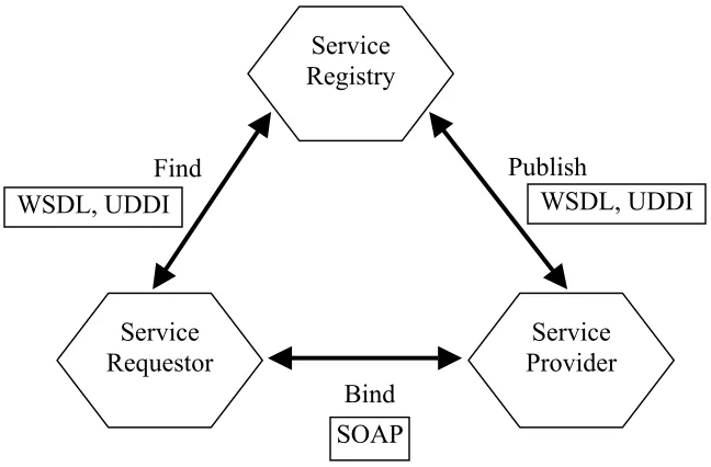
2.1.2 The Web Services Architecture
The Service-Oriented architecture (SOA) has been formalized to represent the
roles and operations of Web Services [10, 11]. Figure 2-1 illustrates the roles and
interactions between the roles of the Web Services architecture.
SOAP WSDL, UDDI
Find
Bind
Publish
WSDL, UDDI
Service Requestor
Service Provider Service
Registry
Figure 2-1. The Web Services Architecture.
In this architecture, a service is the implementation of a Web service, which is an
interface described by a service description. The service description contains the details
of the interface and implementation of the service, which includes its data types,
The Web Services architecture contains three roles: service provider, service
registry and service requestor. The interactions between the three roles involve three
operations: publish, find, and bind.
Service Provider. The service provider is responsible for describing and publishing a
service to the service registry. From a business point of view, this is the owner of the
service. A service provider typically can be any company that hosts a Web service,
which is accessible on some network.
Service Requestor. The service requestor uses a find operation to find a service
description locally or published to the service registry, and uses service descriptions to
bind with the service provider to interact with the Web service implementation. Any
consumer of a Web service, either a browser or a program is a service requestor.
Service Registry. Service registry is the place where service providers publish service
descriptions, and it allows service requestors to search for the published service
descriptions. It acts as a match-maker between service requestor and service provider.
Worth of mentioning, service requestors can obtain service descriptions from sources
other than service registry, such as a local file, Web site, FTP site, Discovery of Web
Services (DISCO), or Advertisement and Discovery of Services (ADS).
In the Web service architecture, three operations must take place to realize
Publish. Publishing a service description to a service registry makes a service description
accessible, so that the service requestor can find it. The complexity of actual details of
publish API varies greatly. It can be simply an act of moving the service description into
a Web application server’s directory structure if the network itself acts as the Service
registry. On the other hand, some service registry implementations, such as UDDI,
makes a very sophisticated publish operation.
Find. The find operation allows the service requestor to retrieve a service description
directly from the service registry, or to query the service registry for the desired type of
service. The service requestor can use find operation at design time to retrieve the
service’s interface description for program development, or at runtime to get the service’s
binding and location description for invocation.
Bind. The bind operation takes place when a service needs to be invoked. The bind
operation allows the service requestor to use the binding details in the service description
to locate, contact and invoke the service.
2.1.3 The Web Services Technology Stack
Although theoretically the Web services architecture is independent of any
particular standards, interoperability is still a key requirement for large-scale adoption of
been making efforts to develop a set of XML-based open standards (SOAP, WSDL,
UDDI, WSFL) that enable the Web services architecture to be implemented. Here I
introduce a conceptual Web Services stack proposed by IBM and Microsoft (Figure 2-2)
[11, 14].
Wire Layer Description Layer
Discovery Layer
HTTP, FTP, email, MQ, IIOP, etc.
SOAP WSDL
Direct → UDDI
Static → UDDI
WSFL Q ua lit y O f S er vic e M an ag em en t S ec ur ity Network XML-Based Messaging Service Description Service Publication Service Discovery Service Flow
Figure 2-2. The Web Services Technology Stack [14].
This model groups various Web services technologies into three layers: the wire
layer, the description layer, and the discovery layer. The upper layers build upon the
capabilities provided by the lower layers. The vertical towers represent requirements that
must be addressed at every level of the stack. The text on the left represents standard
technologies that apply at that layer of the stack. XML is the key technology. Apart
Wire Layer. The wire layer defines the messaging format and components between the
service requestor and the service provider. The base of the wire layer is the network,
which makes Web services accessible to a service requestor. Internet-available Web
Services use commonly deployed network protocols. HTTP is the de facto standard
network protocol for Internet-available Web Services. Other Internet protocols, such as
SMTP and FTP, are also supported. Reliable messaging and call infrastructures, such as
MQSeries, IIOP, and so on, are supported for Intranet Web Services. SOAP is chosen as
the de facto XML messaging protocol for general IT Web services.
Description Layer. The Description layer consists of Web Services description
documents. XML is not only the basis of the Wire layer, it is also the basis of service
description. Web Services Description Language (WSDL) is the de facto standard for
Web Services description in the IT Industry. WSDL defines the interface of a Web
service and mechanisms of service interaction, which specifically include the operations
supported by the Web service, the input and output of the service, the bindings to
concrete network, and data encoding schemes. It is the minimum standard service
description necessary to support interoperable Web Services. Additional description is
needed to specify other properties of Web services, such as quality of service,
service-to-service relationships, and so on. Web Services Flow Language (WSFL) is used to
Discovery Layer. A Web service needs to be discovered in the first place before it can be
invoked. Service discovery closely depends on service publication since a service cannot
be discovered if it has not been published.
The simplest and most static service publication is direct publication [14], in
which the service provider sending a service description directly to the service requestor.
On the other hand, in a complex service publication, a service provider publishes the
service description to a local service registry or UDDI service registry.
In parallel to service publication, service discovery can also be either simple and
static or complex and dynamic. In a static discovery, the service requestor retrieves a
service description from a local file. On the other hand, a service can be discovered at
design time or runtime dynamically from a local registry or a UDDI registry.
2.1.4 SOAP, WSDL, and UDDI
The core industry technologies for the general IT industry Web Services for each
layer currently are: Simple Object Access Protocol (SOAP) for messaging, WSDL (Web
Services Description Language) for description, and UDDI (Universal Description,
2.1.4.1 SOAP
Since its introduction in late 1999, SOAP has become the de facto standard for
Web services messaging and remote procedure calls (RPCs) [11]. SOAP is a simple,
flexible, and highly extensible XML-based messaging protocol [21, 22]. It is
programming language, platform, hardware neutral. Rather than defining a new transport
protocol, SOAP works on exitsing network protocols, such as HTTP, SMTP, FTP, and so
on. Another advantage of SOAP is the ability to pass firewalls, which is essential for a
wide area network.
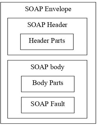
A SOAP message consists of three parts (Figure 2-3).
• An envelope, which provides the framework for packaging message information.
It describes what is contained in a SOAP message and how to process it.
• Encoding rules for serializing data.
• An RPC representation that defines how to represent remote procedure calls and
SOAP Fault Body Parts SOAP body Header Parts SOAP Header SOAP Envelope
Figure 2-3. SOAP Message Structure.
2.1.4.1.1 SOAP Envelope Framework
The envelope framework is the basic core structure of a SOAP message (Figure
2-3). The root element of the SOAP message is the Envelope element. It defines the
various XML namespaces that are used by the rest of the SOAP message. These
represent the SOAP specification namespaces for SOAP and schemas for instances, data
types, and encoding [21, 22].
The SOAP Envelope element can contain an optional Header element and a
Headers are the primary extensibility mechanism in SOAP. The usual
information Header element defines includes authentication and authorization,
transaction management, routings, and payment processing. The actors attribute
specified in the Header element indicate who should which parts of the message, which
enables SOAP intermediaries mechanism.
The SOAP body element contains the core information intended for the final
message receiver. The Body of the SOAP response can contain a single Fault element as
the only child element of the SOAP body to carry SOAP error information. When SOAP
is used to perform an RPC, the body contains a single element that contains the method
name to be invoked and it's arguments. The namespace of the method name is specified
by the web service followed by the type of the target web service. The type of each
argument can be optionally supplied using the xsi:type attribute.
2.1.4.1.2 Messaging Using SOAP
There are two types of messaging pattern using SOAP: the Conversational
Message Exchanges and the Remote Procedure Calls.
The Conversational Message Exchange is a request-response pattern, in which
XML-based content conforming to some application-defined schema are exchanged via
SOAP messages. In the simplest case, the user can only send the SOAP request to the
electronic checkin, provided with name of the checkin method and the fromat for
encoding the ticket.
Remote Procedure Calls (RPCs) with SOAP is used when there is a need to model
a certain programmatic behavior, with the exchanged messages conforming to a
pre-defined description of the remote call and its return. To use SOAP for RPCs, you must
define an RPC protocol, including [7]:
• how typed values can be transported back and forth between the SOAP
representation (XML) and the application’s representation (such as a Java class
for a ticket), and
• where the various RPC parts are carried (object identity, operation name, and
parameters).
The W3C’s XML schema specification (www. w3.org/XML/Schema) provides a
standard language for defining the document structure and the XML structures’ data
types. For the typed values, SOAP assumes a type system based on the one in XML
schema and defines its canonical encoding in XML. Using this encoding style, the user
can produce an XML encoding for any type of structured data. RPC arguments and
responses are also represented using this encoding.
SOAP implementations exist for several programming languages, including C,
Java, and Perl, which automatically generate and process the SOAP messages. Assuming
the messages conform to SOAP specifications, they can thus be exchanged by services
2.1.4.2 WSDL
The Web Services Definition Language (WSDL) is an XML-based standard to
describe the technical invocation syntax of a Web service. A complete WSDL service
description provides two pieces of information: an application-level service description,
or abstract interface, and the specific protocol-dependent details that users must follow to
access the service at concrete service end points. This separation accounts for the fact
that similar application-level service functionality is often deployed at different end
points with slightly different access protocol details. Separating the description of these
two aspects helps WSDL represent common functionality between seemingly different
end points.
An abstract interface can support any number of operations. An operation is
defined by the set of messages that define its interaction pattern. For the abstract
concepts of message and operation, concrete counterparts are specified in the binding
element.
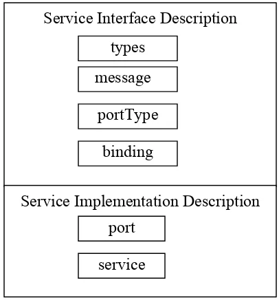
The WSDL schema defines several high level or major elements in the language,
which are introduced in the following [11].
PortType – A Web service’s abstract interface definition where each child
Message – Defines a set of parameters referred to by the method signatures or
operations. A message can be further decomposed into parts.
Types – Defines the collection of all the data types used in the Web service as
referenced by various message part elements.
Binding – Contains details of how the elements in an abstract interface (portType)
are converted into a concrete representation in a particular combination of data formats
and protocols.
Port – Expresses how a binding is deployed at a particular network endpoint.
Service – A collection of ports.
So the portType (with details from the message and type elements) describes the what of
the Web service. The binding element describes the how, and the port and service
elements describe the where of the Web service.
Many developers split their WSDL designs into two parts, each placed in a
separate document. The service interface definition, containing the types, message,
portType, and binding elements, appears in one file. You can then place this file, for
example, on a well-known Web site (on an e-marketplace, for example) for everyone to
view. Each organization that wants to implement a Web service conformant to that
well-known service interface definition would describe a service implementation definition,
containing the port and service elements, describing how that common, reusable, service
interface definition was, in fact, implemented at the network endpoint hosted by that
Figure 2-4 outlines how the major elements in WSDL are divided between the
service interface definition and the service implementation definition.
service port
types
message
binding portType
Service Implementation Description Service Interface Description
Figure 2-4. The Key Elements of a WSDL file.
2.1.4.3 UDDI
UDDI is an XML-based registry for Web Services. It defines a way to publish
and discover information about services on the Web. The main purpose is to support
business to business (B2B) activities. UDDI can be compared to telephone books: it
consists of white pages (locate service by name), yellow pages (locate service by type of
offering or topic, and green pages (locate service by its characteristics). Every project or
company can put its services to the registry by giving information about the product,
XML, the registry can also describe services implemented in HTML, CORBA, or any
other type of programming model or language.
UDDI provides two basic specifications that define a service registry’s structure
and operation [27, 7]:
• A definition of the information to provide about each service, and how to
encode it; and
• A query and update API for the registry that describes how this
information can be accessed and updated.
Registry access is accomplished using a standard SOAP API for both querying
and updating. Unique keys identify each data entry - businesses, services, and so on -
that might be cross-referenced. Theses assigned keys are long hexadecimal strings
generated when the entity (in this case, a business) is registered. The keys are guaranteed
to be universally unique identifiers (UUIDs).
2.2 OGC Web Services
2.2.1 Overview of OGC Web Services
Within the broader context of Web Services, OGC Web Services (OWS)
represent an evolutionary, standards-based framework that enable seamless integration of
popular definition of OWS is “self-contained, self-describing, modular applications that
can be published, located, and invoked across the Web”, OGC Web Services only
provide implementation specifications for GIS Web Services applications. Attention
must be paid to terminology: when OGC speaks of Web Services, they mean their
specifications, which are not equivalent to the general SOAP-based Web Services. This
is reasonable, because OGC does not intend to specify general issues that are not specific
to Geographic Information.
OWS is one of OGC’s many initiatives for addressing the lack of interoperability
among systems that process georeferenced data. In the past several years, OGC has
successfully executed several phases of the OWS initiative, including Web Mapping
Testbed I (WMT-I) in 1999, WMT II in 2000, OGC Web Service Initiative 1.1 (OWS
1.1) in 2001, and OWS 1.2 in 2002, and produced a set of web-based data interoperability
specifications. These specifications include, but are not limited to: Web Map Server
(WMS), Web Feature Server (WFS), and Web Coverage Server (WCS).
Each of these specifications defines a number of services. Together these services
are referred to as OGC Web Services (OWS). OGC Web Services allow geospatial
information to be accessed and processed over the Internet. Geospatial information is
2.2.2 OGC Web Services Specifications
Here I will describe three major OGC Web Services implementation
specifications, WMS, WFS, and WCS. These documents specify details for the OGC
Web Services interfaces. Any software which implements one or more of these
specifications should then be able to communicate with any other software that
implements the same specification(s).
2.2.2.1 Web Map Service
The Web Map Service (WMS) specification [30] standardizes the way in which
clients request maps. Clients requests maps from a WMS instance in terms of named
layers and provide parameters such as the size of the returned map as well as the spatial
reference system to be used in drawing the map.
The specification defines three WMS operations: GetCapabilities returns
service-level metadata, which is a description of the service’s information content and acceptable
request parameters; GetMap returns a map image whose geospatial and dimensional
papameters are well-defined; GetFeatureInfo (optional) returns information about
particular features shown on a map.
When requesting a map, a client may specify the information to be shown on the
Earth is to be mapped (a “Bounding Box”), the projected or geographic coordinate
reference system to be used (the “Spatial Reference System”, or SRS), the desired output
format, the output size (Width and Height), and background transparency and color.
The OGC Web Map Service (WMS) implementation specification version 1.1.0
defines keyword/value encodings for operation requests using HTTP GET and POST.
2.2.2.2 Web Feature Service
The Web Feature Service (WFS) [29] supports operations such as INSERT,
UPDATE, DELETE, QUERY, and DISCOVERY of geographic features. WFS delivers
GML representations of simple geospatial features in response to queries from HTTP
clients. Clients access geographic feature data through WFS by submitting a request for
just those features that are needed for an application. A WFS can either be a basic WFS
(a READ-ONLY WFS), which implements the GetCapabilities, DescribeFeatureType
and GetFeature interfaces, or a transaction WFS, which, in addition to supporting all the
interfaces of a basic WFS, implements the Transaction interface (and optionally the
LockFeature interface).
To support transaction and query processing, the following WFS interfaces are
- GetCapabilities: A web feature server must be able to describe its capabilities.
Specifically, it must indicate which feature types it can service and what
operations are supported on each feature type.
- DescribeFeatureType: A web feature server must be able, upon request, to
describe the structure of any feature type it can service.
- GetFeature: A web feature server must be able to service a request to retrieve
feature instances. In addition, the client should be able to specify which feature
properties to fetch and should be able to constraint the query spatially and
non-spatially.
- Transaction: A feature server may be able to service transaction request. A
transaction request is composed of operations that modify features; that is create,
update, and delete operations on geopraphic features.
- LockFeature: A web feature server may be able to process a lock request on one
or more instances of a feature type for the duration of a transaction. This ensures
that serializable transactions are supported.
WFS requests, encoded in XML or keyword-value pairs, may be transmitted to a
web feature server using either the POST or GET methods. However, the XML encoding
is most suitable for packaging as an HTTP POST request and the keyword-value pair
2.2.2.3 Web Coverage Service
The Web Coverage Service (WCS) [28] supports the networked interchange of
geospatial data as “coverages” containing values or properties of geographic locations.
Unlike the Web Map Service, which returns static maps (server-rendered as pictures), the
Web Coverage Service provides access to intact (unrendered) geospatial information, as
needed for client-side rendering, multi-valued coverages, and input into scientific models
and other clients beyond simple viewers.
The Web Coverage Service consists of three operations:
- GetCapabilities: required operation which returns a description of the service
with elements to describe multidimensional data collections from which a coverage may
be requested.
- GetCoverage: required operation returns values or properties of geographic
locations, bundled in a well-known coverage format. Its syntax and semantics are similar
to the WMS GetMap request, but several extensions support the retrieval of coverages
rather than static maps.
- DescribeCoverageType: optional operation returns a description of the structure
2.3 Microsoft TerraService
The Microsoft TerraServer (http://terraserver.net) web site has been optional since
1998. It stores aerial, satellite, and topographic images of the earth in an SQL database
available via the Internet. It is the world’s largest online atlas, combining fifteen
terabytes of aerial imagery data and 1.5 terabytes of topographic maps from the United
States Geological Survey (USGS). The TerraService web service provides a
programmatic interface to the TerraServer database. The TerraService web methods are
designed to support an OpenGIS compatible Web Map Server application. Microsoft, the
USGS, and USDA are members of the OpenGIS.
Briefly, TerraServer is a database repository of high resolution, ortho-rectified
imagery that is logically represented as a “seamless mosaic of earth” at several scales
(meters per pixel). The TerraService also provides a landmark service that returns place
names and a list of all the places within a specified area.
The mosaic is stored as sets of uniformly sized, JPEG or GIF compressed images
called tiles. Each tile has a predictable resolution and location on the earth. The
TerraService is a “tile service”. TerraService methods enable consuming applications to
query the TerraServer database of tiles by a number of different methods to determine the
existence of tile data over some expanse of geographic territory. Data returned by tile
query methods enable a calling application to determine the set of tiles required to build a
iteratively call TerraService’s GetTile() method to actually retrieve the individual tiles,
construct a new, larger image, and then crop, re-size, and/or layer other graphic data
on-top of the image.
As the way the TerraService is used in this implementation case study,
applications typically access it to build an image from multiple TerraServer tiles to use as
a background image for some geo-spatial display.
2.4 ArcSDE
ESRI enterprise GIS solution is based on a centralized geo-spatial database. To
facilitate spatial data sharing and management, the solution include SDE (Spatial Data
Engine) server that acts as an application server. ESRI ArcSDE is an application server
that facilitates storing and managing spatial data (raster, vector, and survey) in a DBMS
and makes the data available to many kinds of applications. ArcSDE server also
maintains the data integrity, manage the transaction, and tune the overall performance of
the spatial data service. ArcSDE allows user to manage spatial data in one of four
commercial databases (IBM® DB2InformixMicrosoft® SQL Serverand Oracle®). Here,
the feature data are managed by ArcSDE on top of an Oracle database.
The ArcSDE server also provides a set of API for customized application
development. ArcSDE contains two main application programmer interfaces for
multi-user geo-databases: ArcSDE Client API for C programmers and ArcSDE Client API for
Java programmers. These APIs provide GIS functions for advanced application
development. ArcSDE works as an application server, delivering spatial data to many
kinds of applications or even serving spatial data across the Internet.
Since our main purpose here is to demonstrate the functionality of the
TerraService web service, the feature data can be from any other sources (e.g., from local
disk or from a Web Feature Server). In fact, the implementation is designed for
displaying any set of point feature data.
CHAPTER 3 GENERAL AND OGC WEB SERVICES INTEGRATION
As the global players of IT like IBM and Microsoft push the development of the
core standards of Web services (SOAP, WSDL, and UDDI), well-known companies have
implemented their own Web Services technologies using these standards (e.g., IBM
WebSphere, Microsoft .NET, and SUN ONE). The huge impact of these core standards
on the development of the SOAP-based Web Services should not be ignored as OGC
engages in their Web Services Initiatives. In fact, OGC has started putting efforts on
integrating the SOAP-based Web Services technologies into the OGC Web Services
framework.
OGC Web Service (OWS) specifications provide standards for implementing
interoperable, distributed geospatial information processing software systems (e.g. GIS),
by which a user can easily share geospatial data, information, and services with others.
However, OGC technology consists mainly of interface specifications and content
standards. They do not provide a mechanism for efficiently sharing the distributed
computational resources. Meanwhile, the SOAP-based Web Services technology,
because of its powerful distributed resource sharing capabilities, has earned tremendous
popularity and market. Therefore, the integration of general Web services technology
In this chapter, I will review the current status of the integration of the
SOAP-based web services technologies into the OGC web services infrastructure. First, I will
compare the OGC web services architecture with the SOAP-based Web Services
architecture. Then I will examine the OGC Web Services Technology Stack to identify
the general Web Service technologies already named by OGC in their envisioned
infrastructure. After that, I will review the OGC activities of promoting the integration.
An example of the integration is also provided. Finally, the system design of my
implementation case study is introduced.
3.1 OGC Web Services Architecture
The OpenGIS Web Services architecture defines a common set of interfaces that
can be utilized by any application to provide enterprise-wide interoperabilities [19].
Figure 3-1 [13] depicts the Computational Viewpoint of the OGC Web Services
architecture for OWS 1.2. At the core of the architecture are network-based, distributed,
modular components that perform specific tasks and conform to specific sets of technical
specifications that make them interoperable with compatible components. Here only
important elements of each component are introduced. The summary description of each
Figure 3-1. OGC Web Services Architecture [13].
Encodings. The encodings describe specialized vocabularies for the transfer of specific
kinds of data packaged as messages between application clients and services and between
services. Each encoding vocabulary is designed for a specialized use within the
architecture. All OWS encoding specifications are application schemas for XML. The
most important encoding standard in OGC Web Services is Geography Markup
Language (GML) [9]. GML is an XML grammar written in XML Schema for the
modeling, transport, and storage of geographic information. GML provides a variety of
kinds of objects for describing geography including features, coordinate reference
systems, geometry, topology, time, units of measure, and generalized values.
Registry Service. Registry Service provides a common mechanism to classify, register,
services). For OWS1.2, Registry Services include Web Registry Service (WRS), for
which the OGC discussion paper is available. Web Registry Server(WRS) interfaces
support “one stop shopping” for the registration, metadata harvesting and descriptor
ingest, push and pill update of descriptors, and discovery of OGC web services types and
instances using HTTP as the distributed computing platform.
Data Services. Data Services are the foundational service building blocks that serve data,
specifically geospatial data. For OWS1.2, Data Services include Web Object Service
(WOS), Web Feature Service (WFS), Sensor Collection Service (SCS), Image Archive
Service (IAS) and Web Coverage Service (WCS).
Portrayal Services. Portrayal Services provide specialized capabilities supporting
visualization of geospatial information. Portrayal Services are components that, given
one or more inputs, produce rendered outputs such as cartographically portrayed maps,
perspective views of terrain, annotated images, views of dynamically changing features
in space and time, etc.). For OWS1.2, Portrayal Services include Web Map Service
(WMS), Coverage Portrayal Service (CPS) and Style Management Service (SMS).
Processing-Workflow Services. Processing-Workflow Services are the foundational
application-building-block services that operate on geospatial data and metadata,
providing value-add service. For example, the most common type of geo-coding
Client Services. Client Services are the client-side components of client applications that
interact with users, and on the server-side interact with Server-side Client Applications,
Application Servers and Data Servers.
In this architecture, OGC services are categorized according to similar
functionalities. Figure 3-1 indicates two important characteristics of OGC services.
First, the great complexity of Geographic data determines a relatively large number of
different service interfaces are defined. The quality of GIS Web Services depends on an
easy interaction between and good interoperability of these services determines. Second,
Figure 3-1 implicates that OGC Web services has the same Publish-Find-Bind (PFB)
SOA architecture as general web services. It is this SOA paradigm that essentially
underpins the Computational and Information Viewpoints of OGC Web Services. In
OGC documents, it is called the Service Trading model and the equivalent PFB
terminology is broker (service registry), requester, and provider [19]. These two
characteristics of OGC Web Services from a certain degree have determined the
dependence of OGC Web Services on the powerful general Web Services technology.
Thus, integration of these two areas is inevitable.
3.2 OGC Web Services Technology Stack
OGC’s Services Interoperability Stack (Figure 3-2) has already named all the core
technologies in General IT Web Services [19]. The OGC Services Interoperability Stack
implemented and deployed. The lowest levels of the stack enable connectivity of
software components by enabling them to bind, send and receive messages. Higher
levels in the stack enable interoperability and, via publish-find-bind mechanisms, allow
software components to transparently work together in more integrated and dynamic
ways.
TCP/IP, HTTP, SSL, SMTP, FTP, IIOP, etc.
ASCII, ASN.1/DER, XML, etc. HTML, XML/S, RDF, XML, OGC-GML, OGC-WKR/WKB, etc.
HTTP, SOAP, COM, CORBA, SQL, J2EE, etc.
OGC SF, Coverage, Coordinate Transform, WMS, etc.
WSDL. ISO-19119, etc. UDDI, OGC-Catalog, etc. WSFL, XLANG, ISO19119
Interoperability Standards Interoperability Layers
Communication Protocols Data Representation &
Encoding
Data Format, Schema and Semantics
Binding Service Service Description
Service Discovery Service Integration &
Workflow Interoperability
Connectivity
Figure 3-2. OGC Web Services Interoperability Stack [19].
This stack overlaps with the general Web Services Stack very well. The overlap
possibility and practicability of porting OGC Web services into General IT Web
Services.
3.3 Comparison of the Models of General and OGC Web Services
Figure 3-3 maps general Web Services and OGC Web Services according to the
SOA model. As depicted in Figure 3-3, architectural similarity exists between the two
areas. Both confirms to the SOA model. Also in terms of technology, as I have
mentioned before, OGC names all major technologies (UDDI, WSDL, SOAP) in its
envisioned architecture. However, OGC defines and adopts different standards other
than those from general Web Services.
HTTP 1, 2, 3
Find
Bind
Publish 1, 2, 3
Requestor Provider
Broker
1: ISO 19119 2: Capabilities XML 3: Catalog Services
For service registry, OGC has its own registry services, Catalog Services.
Catalog services define the set of service interfaces which support organization,
discovery, and access of geospatial information. A Catalog can be thought of as a
specialized database of information about geospatial resources available to a group or
community of users. These resources are assumed to have OpenGIS feature, feature
collection, catalog and metadata interfaces, or they may be geoprocessing services.
Catalogs have three essential purposes:
• to assist in the organization and management of diverse geospatial data and
services for discovery and access,
• to discover resource information from diverse sources and gather it into a single,
searchable location, and
• to provide a means of locating, retrieving and storing the resources indexed by the
catalog.
OGC employs ISO 19119 and Capabilites XML for its service description. ISO
19119 provides a framework for creating and sharing Geographic Information Services.
The ISO service and operation metadata are richer than those of WSDL. Capabilites
XML is a format defined by OGC itself. Every OGC Web Service provides an operation
“getCapabilities”, which returns a “Capabilities XML” document describing the
operations of the service. As with ISO 19119, the service metadata are richer than in
WSDL. For example, in ISO 19119, geographic information of the data on which the
Geographic Description. However, the operation metadata basically restrict to the
signature.
Generally UDDI, WSDL, and Capabilities XML focus on operation signatures;
descriptions are available only on service level and appear as free text. ISO 19119
provides free text descriptions not only on service, but also on operation level, and in
addition to data types for operation parameters it contains a pointer to permitted values.
Although this is a richer description of the context in which the service is used, there is
still semantic information missing. The semantic description of service content will
provide more powerful service discoveries and more interoperable service interactions.
As to the communication protocol, OGC specified HTTP as the standard
communication protocol for OWS, like WMS and WFS. SOAP is on its way of being
tested by OGC before it is specified as the standard communication protocol for OWS
(see section 3.4).
The inherent complexity of Geographic information may require the necessity of
native OGC standards to complement the insufficiency of general Web Services
technology to solve GIS problems. The extension of general Web Services technology
3.4 OGC Integration Activities
Efforts have been made by OGC to integrate general Web services technologies
into OGC Web services framework.
The objectives of OWS-1.2, OGC Web Services Initiative Phase 2, address issues
involving the adoption and integration of Web Services technology broadly adopted
within the Information Technology industry by leading organizations such as W3C,
OASIS, and the open-source community [15]. A major issue is about the question of
whether and how to adopt the core Web Service technologies (WSDL, SOAP, and
UDDI). Specifically, OWS-1.2 has executed two relevant experiments to address these
issues, which are SOAP experiment and UDDI experiment.
3.4.1 OGC SOAP Experiment
The premise of OGC SOAP experiment (SOAP implementation of OGC) [16] is
the belief that porting OWS services to Web Services will offer several key benefits,
including:
• Distribution -- It will be easier to distribute geospatial data and applications across
platforms, operating systems, computer languages, etc.
• Integration -- It will be easier for application developers to integrate geospatial
• Infrastructure -- The GIS industry could take advantage of the huge amount of
infrastructure that is being built to enable the Web Services architecture --
including development tools, application servers, messaging protocols, security
infrastructure, workflow definitions, etc.
This experiment discusses how OWS services can be ported to the SOAP-based
Web Services and highlights various issues/problems that have been discovered. In this
experiment, the appropriate XML Schema and Web Service Definition Language
(WSDL) files were defined, which allow WMS services to be invoked using standard
protocols such as HTTP GET, HTTP POST and SOAP. Standard Web Services toolkits,
such as Visual Studio .NET, Apache Axis, XML Spy, and so on, were used to invoke
OGC Web Services across the Internet.
A number of very specific issues on using Web Services standards and Web
Service toolkits to call a WMS server have been identified. They are very specific to
each adopted toolkit. For example, .NET does not support importing multiple XML
Schema files that have the same target namespace. A workaround was found for each of
the problems.
In summary, the adopted Web Service toolkits successfully invoked the services
of a Web Map Server by successfully generating client proxies from a given WSDL.
However, specific problems exist for different toolkits, and workaround solutions are
3.4.2 OGC UDDI Experiment
The OGC UDDI experiment [17] used UDDI (Universal Discovery, Description,
and Integration) registries to discover geospatial content in general and OGC services in
particular. This work was performed for the OGC’s Interoperability Program OWS1.2
testbed initiative. Catalog interfaces and service information models have been
developed within OGC specifically for geospatial purposes. This effort has been largely
self-contained, however, and not particularly accessible from the general Web Services
world. UDDI, on the other hand, has made the most progress of any service registry
towards universal acceptance and accessibility, but has not been specifically adapted for
geospatial applications.
The premise of the experiment is to determine whether and how the reach of
UDDI might be combined with the geospatial focus of OGC services development to
make geospatial content and services more universally discoverable and consumable by
non-GIS users. The participants in this experiment will take a variety of approaches to
coordinating OGC services and UDDI registries, as expressed in the User Scenarios
below. The approaches all center around developing a crosswalk between the OGC and
UDDI service information models.
The goal of the experiment will be to assess the practicality of both the crosswalk
and the coordination scenarios, as well as to make concrete recommendations for
There were four general usage scenarios underlying this experiment. In Discover
OGC Registries, user binds to a general purpose UDDI registry to discover specialized
registries (and clients) for geospatial data and services. User then switches to Discover
OGC Services, here user binds to a general-purpose UDDI registry to discover OGC
services which have been published to it, either manually or automatically. In Discover
OGC services with UDDI interface to OGC registry, user makes use of general purpose
UDDI clients against OGC registries with UDDI interfaces to discover OGC services and
build clients to them. In Publish OGC service to UDDI, user employs a general purpose
UDDI publishing client to publish an OGC service directly to UDDI. The service
metadata may or may not then be made available through a corresponding OGC registry
interface or service.
The general design principle is that the OGC Service Information Model and the
OGC Service Registry Model should be mapped onto the UDDI information model with
as few changes as possible. Specifically, the UDDI registries for OGC services should be
compatible with W3C standards efforts such as HTTP and XML, and compatible with
other relevant OGC specification and pre-specifications efforts, including Service
Information Model, General Service Model, Registry Information Model, and Web
Catalog/Registry Service.
The UDDI experiment produced examples of discovering OGC services through
UDDI interfaces, as well as means of mapping the UDDI metadata model to the metadata
through UDDI showed that theses tasks are possible. However, the “fit” of the OGC
models with the UDDI model and interfaces is poor. This is especially true when
considering the capabilities of available UDDI clients to make full (or extended) use of
the UDDI service interfaces. For example, testing with Sun UDDI registry demonstrates
that this client lacks of resources for making use of the publisher API. The tentative
conclusion drawn from this experiment is that UDDI Version 2 is best suited for
discovering the existence of services based on very general taxonomic or classification
criteria. It is not suited for obtaining the information to bind to a specific GIS service,
and even less well suited to discovering specific contents or capabilities of individual GIS
service instances.
3.4.3 Using WSDL in OGC Web Services
Even though, OGC does not have experiments to test the use of WSDL in OGC
Web Services, there are discussions about the advantages and issues of adoption of
WSDL into OGC Web Services.
An OpenGIS discussion paper has pointed out that OGC can take the following
advantages of WSDL [19]:
• XML-schema based description provides references to abstract types from which
service instances can attach instance specific service offer information
• Syntax for instance specific “binding” of access point to “ports”.
On the other hand, the insufficiency of WSDL for GIS Web Services also has
been recognized. WSDL was used in OWS 1.1 in the OperationSignatures portion of a
service XML Capabilities document. WSDL was designed so that a programmer could
discover and build an interface to a particular service instance, given an understanding of
the semantics of a given operation. WSDL would allow automatic generation of “Stub”
code for the interface. Basically a programmer would be required to extend this
according to an understanding of the semantics of the content and the operations. Further
knowledge of the content is required to “bind” to the service with a meaningful query.
The emphasis in WSDL definition is flexibility, inclusiveness, and extensibility.
However, for the services in the GIS domain, the syntax of the operation is constant, and
the content of service instances varies. The WSDL descriptions of “content access”
services could be too general and abstract for GIS usage. WSDL does provide a
syntactical framework for normative descriptions of “well known services” such as
WMS.
3.5 An Example of Integration – ESRI ArcWeb
Besides the OGC experiments on integrating the general Web services
technologies, some leading GIS software vendors have integrated the two areas in their
practicability of such an integration. ESRI ArcWeb is a good example of the GIS Web
services, which integrates both core general technologies and OGC Web Services
standards.
3.5.1 ArcWeb Overview
ESRI’s ArcWeb Services [2, 3] are a type of Web service that provides spatial
data and GIS functionality via the Internet to ArcGIS and custom Web applications.
ArcWeb Services offer a way for developers to include GIS content and capabilities in
their applications without having to host the data or develop GIS tools themselves,
resulting in significant savings of development time, expense, and computer resources.
The services provided by ArcWeb are from simple mapping to complex tasks
such as multipoint routing. The rich set of services makes creating lightweight,
Web-enabled applications fast and simple. ArcWeb Services allow developers to use a rich
offering of up-to-date data content, with more data being added all the time. The data
accessible through ArcWeb include GDT United States Streets, USGS National Elevation
Data, USGS National Land Cover Data, FEMA Q3 Flood Data, Census 2000 Population,
ESRI Data & Maps, and so on [2].
3.5.2 ArcWeb Architecture
ArcWeb Services use SOAP to communicate so they are compatible with some of
the implementation of ArcWeb Services because the communication protocol is handled
automatically. ArcWeb Services can also communicate directly through SOAP for
clients not using Web service toolkits. ArcWeb Services are described in WSDL.
ArcWeb Services are published to a Universal Description, Discovery, and Integration
(UDDI) registry so developers can easily discover them. The ArcWeb Architecture
which integrates both the general Web Service technology and the OGC Web Services
standards is shown in Figure 3-4 [2, 27].
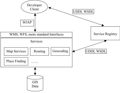
WMS, WFS, more standard Interfaces
UDDI, WSDL
GIS Data SOAP
UDDI, WSDL
Service Registry
Geocoding Services
…… Place Finding
Routing Map Services
Developer Client
The key advantages of using ArcWeb for Developers are the following [2]:
• Access to vast amounts of current, reliable data and GIS capabilities
without having to maintain or store the data or develop the GIS
capabilities yourself;
• Ability to combine multiple services (such as address matching, routing,
point of interest [POI] management, and more) and integrate these
services with your own application environment, leading to limitless
possibilities for sharing geographic information;
• No need to purchase hardware or software;
• No need to obtain updates to data sets because the data accessed via
ArcWeb for Developers is always current;
• 24/7 reliability;
• Standards-based (SOAP/XML interface, Web Services Description
Language [WSDL] access, published on the Universal Description,
CHAPTER 4 DESIGN AND IMPLEMENTATION: AN EXPERIMENT ON A
SOAP-BASED GIS WEB APPLICATION
4.1 Overview
In this chapter, I report my experiment on a SOAP-based GIS Web application.
This is an implementation of a client of Microsoft TerraService, which retrieves DOQ
map images from the TerraService. It uses SOAP as the communication protocol. To
demonstrate the use of map images, additional feature data from a local ArcSDE server
are overlapped on the map images. Some related query functions are also implemented.
The Java Web Services Developer Pack (Java WSDP) 1.2 [25] is used to
construct SOAP messages to communicate between the client and the TerraService. The
TerraService Data Structures, such as AreaBoundingBox, AreaCoordinate, LonLatPt, …,
are implemented in Java to provide parameters for the TerraService methods. SOAP
messages are constructed using Java WSDP to communicate with TerraService methods
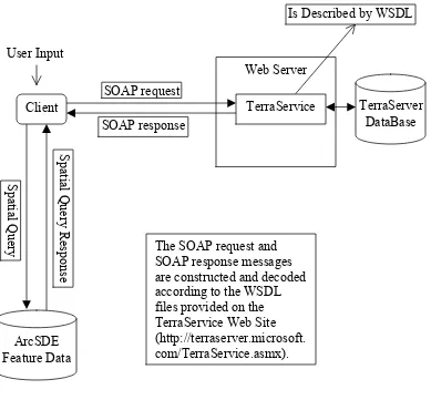
4.2 Design Architecture
In this section, I introduce the design architecture of my implementation
experiment. This implementation allows the user to provide the center longitude and
latitude, width and height of the map. SOAP messages are constructed according the user
input to retrieve DOQ images. ArcSDE feature data are then retrieved and displayed on
the map image. Without storing any image data on the local disk, the user can get any
map image area she/he wants from the TerraService. This again shows the beauty of
the TerraService ArcSDE Feature Data Client S pa tia l Q ue ry R es po ns e S pa tia l Q ue ry TerraServer DataBase Web Server
Is Described by WSDL
The SOAP request and SOAP response messages are constructed and decoded according to the WSDL files provided on
TerraService Web Site (http://terraserver.microsoft. com/TerraService.asmx). SOAP response
SOAP request User Input
Figure 4-1. Implementation Design Architecture.
4.3 Implementation Workflow
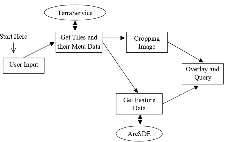
The implementation is carried out according to the workflow shown in Figure 4-2.
First, the program constructs SOAP request messages to get image tiles from
TerraService according to the user input, which specifies the position (center longitude
and latitude) and extent (width and height) of the map. Meanwhile, the meta data for the
map image. The cropping of the image is done after obtaining the images tiles and their
meta data. The tile meta data also provide the input bounding box for the spatial query to
retrieve ArcSDE feature data. Once the ArcSDE data are retrieved from the database,
overlay of feature data and map image is done. Some query functions are implemented in
the mean while.
Start Here
ArcSDE TerraService
Overlay and Query
Get Feature Data
Cropping Image Get Tiles and
their Meta Data
User Input
Figure 4-2. Workflow of Implementation Experiment
4.4 TerraServer Image Storage
Here I will provide some basic introduction of the image storage of TerraServer,
which is necessary for understanding how the implementation works [5]. TerraServer
![Figure 2-2. The Web Services Technology Stack [14].](https://thumb-us.123doks.com/thumbv2/123dok_us/8923833.1844267/21.612.98.559.212.452/figure-web-services-technology-stack.webp)
![Figure 3-1. OGC Web Services Architecture [13].](https://thumb-us.123doks.com/thumbv2/123dok_us/8923833.1844267/42.612.152.535.71.306/figure-ogc-web-services-architecture.webp)
![Figure 3-2. OGC Web Services Interoperability Stack [19].](https://thumb-us.123doks.com/thumbv2/123dok_us/8923833.1844267/45.612.124.516.253.542/figure-ogc-web-services-interoperability-stack.webp)
![Figure 3-3. Architectural Similarity between General and OGC Web Services [19].](https://thumb-us.123doks.com/thumbv2/123dok_us/8923833.1844267/46.612.149.478.371.646/figure-architectural-similarity-general-ogc-web-services.webp)