1
Irrigation Management
David L. Bjorneberg,* Robert G. Evans, and E. John Sadler
Abstract
Competition for limited water supplies continues to restrict water available for irriga-tion. Irrigated agriculture must continually improve irrigation management to continue producing food, fiber, and fuel for a growing world population. Precision irrigation is the process of applying the right amount of water at the right time and place to obtain the best use of available water. Precision irrigation management is needed on large irri -gation projects so water delivery matches irri-gation needs and on individual fields to apply the right amount of water at the right time and place. Technology is commercially available to precisely apply water when and where crops need it; however, user-friendly decision tools are still needed to quantify specific irrigation needs and control water application within fields. Integrating information from various sensors and systems into a decision support program will be critical to highly managed, spatially varied irrigation.
I
rrigation supplements precipitation in the hydraulic cycle with the primary goalof meeting the transpiration needs of crops. Ideally, all applied irrigation water
would be beneficially used by crops. However, irrigation systems cannot be con -trolled and operated to apply the exact amount of water that each individual plant requires. Applying too much water in an area can cause deep percolation and
leaching. Applying water faster than it can infiltrate results in ponding and run
-off. Ponded water can evaporate and therefore is not beneficially used by crops. Runoff water either flows from the field, becoming on off-site problem, or infil
-trates in other areas of the field causing nonuniform soil water content in the field. Continued nonuniform irrigation with in-field runoff can cause deep percolation in areas where runoff infiltrates. In addition to being a nonbeneficial use of water, deep percolation and off-site runoff often transport nutrients and sediment.
Irrigation research and development has historically attempted to uniformly irrigate fields even though fields are seldom uniform. Even large irrigation projects often deliver water uniformly to all fields within the project regardless
Abbreviations: ET, evapotranspiration; ICID, International Commission on Irrigation and Drainage;
SSIM, site-specific irrigation management.
David L. Bjorneberg, USDA-ARS, 3793 N 3600 E, Kimberly, ID 83341-5076. Robert G. Evans, 32606 W. Knox Road, Benton City, WA 99320 ([email protected]). E. John Sadler, Rm. 269 Agric. Eng. Bldg., University of Missouri, Columbia, MO 65211 ([email protected]). *Corresponding author ([email protected]).
doi:10.2134/agronmonogr59.2013.0025
© ASA, CSSA, and SSSA, 5585 Guilford Road, Madison, WI 53711, USA.
Precision Conservation: Geospatial Techniques for Agricultural and Natural Resources Conservation
of crops grown or irrigation systems used. The goal of precision irrigation is to apply the right amount of water at the right time and place at any scale.
Precision irrigation often confers images of center-pivot irrigation systems with sprinklers pulsing on and off as the machine rotates through the field. Varying irrigation rates within a field, however, is only one facet of precision irrigation. Precision irrigation can be applied at any scale or with any type of irrigation. At
the irrigation project scale, managers need to know crop water requirements so irrigation diversions can be adjusted to meet the irrigation demand. Irrigators at the farm scale need similar information to ensure that their water supply can
meet the needs of the crops on their farm. On individual fields, farmers need to
know crop water requirements to schedule irrigation and have irrigation systems
with the capability and flexibility to apply the right amount of water in the right
place and time.
In humid, and even semiarid areas, crop irrigation requirements must be determined throughout the growing season to account for precipitation and vari-ations in crop growth to precisely irrigate. In arid areas, precipitation during the
growing season is usually minimal; however, arid areas still benefit from in-sea
-son measurements of crop water use to precisely apply irrigation water. Precision
irrigation requires knowledge of crop water needs, soil water holding capacity, irrigation system capacity, and available water supply. If any one of these factors
is not considered, irrigation water can be over- or underapplied. Insufficient irri -gation will reduce crop yield and will cause unacceptable quality for some crops.
Irrigating too much wastes water and can cause runoff or deep percolation.
All of the precision seeding, tillage, fertility, and conservation concepts for nonirrigated farming apply to irrigated production with the advantage—and
complication—of the ability to vary water application. Precision irrigation is
perhaps the most complicated aspect of precision agriculture because irrigation decisions are made multiple times each season, and irrigation interacts with fer-tilizer and disease management. Crop water use, for example, can be greater at higher N fertilization rates (Lenka et al., 2009) or similar between low and high
rates (Holmen et al., 1961). Pandey et al. (2000) showed that maize (Zea mays L.) yield reductions to water shortage were greater at high N fertilization rates than low rates. Crop response to applied water cannot be assumed to be the same
under uniform irrigation management and site-specific irrigation (Sadler et al., 2002). Intuitively, lower-yielding areas in an irrigated field should require less water and fertilizer. However, low-yielding areas may require more water and
nutrients per unit of production. If water supply is limited, the best practice may be to not irrigate low-yielding areas and focus irrigation on higher-yielding areas.
Precisely applying irrigation water can also alleviate some soil issues by ensuring that water application rates match soil infiltration rates. Technology to precisely apply irrigation water is wasted if the water does not infiltrate into the soil where it was applied and remain in the soil profile for the crop to use.
The purpose of this chapter is to discuss aspects and technologies affect
-ing precision irrigation. One major aspect affect-ing precision irrigation is the
availability of water to irrigate. Managing an irrigation system connected to
a high-capacity well is not restricted by water supply. Off-site water suppliers,
water supply. Another major aspect of precision irrigation is determining crop water needs so adequate water can be supplied to an entire irrigation project or
applied on irrigated farms and fields. Finally, technology for managing irrigation application on fields is discussed.
Background
Irrigation is the process of artificially applying water to soil with the intention of improving crop yield and quality. Humans have used irrigation to help provide more stable food production for 8000 yr, initially diverting and channeling flood
-waters from the Nile or Tigris and Euphrates Rivers. Irrigation equipment and techniques have evolved from hand-dug ditches and wild flooding to carefully
controlled microirrigation and variable-rate, center-pivot machines that can be operated remotely from cell phones or computers. Irrigation enhances the
mag-nitude, quality, and reliability of crop production. According to the Food and
Agriculture Organization of the United Nations, irrigation contributes to ~40% of the world’s food production on <20% of the world’s crop production land. In
the United States, only 8% of the total cropland is on farms where all crops are irrigated (USDA-NASS, 2014a). These farms produce 27% of the market value of crops and 12% of the total market value of all livestock. Half of the crop value is
produced on farms with some irrigated land, and these farms account for only
28% of the total cropland in the United States (USDA-NASS, 2014b).
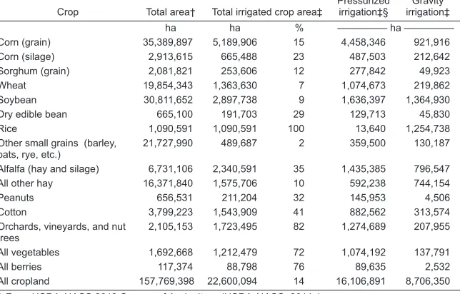
Certain crops rely heavily on irrigation (Table 1). All rice (Oryza sativa L.) in
the United States is grown with irrigation, while only 9% of the soybean [Glycine
Table 1. Total and irrigated crop area in the United States.
Crop Total area† Total irrigated crop area‡ Pressurized irrigation‡§ irrigation‡Gravity
ha ha % ————— ha —————
Corn (grain) 35,389,897 5,189,906 15 4,458,346 921,916
Corn (silage) 2,913,615 665,488 23 487,503 212,642
Sorghum (grain) 2,081,821 253,606 12 277,842 49,923
Wheat 19,854,343 1,363,630 7 1,074,673 219,862
Soybean 30,811,652 2,897,738 9 1,636,397 1,364,930
Dry edible bean 665,100 191,703 29 129,713 45,830
Rice 1,090,591 1,090,591 100 13,640 1,254,738
Other small grains (barley,
oats, rye, etc.) 21,727,990 489,687 2 359,500 130,187 Alfalfa (hay and silage) 6,731,106 2,340,591 35 1,435,385 796,547 All other hay 16,371,840 1,575,706 10 592,238 744,154
Peanuts 656,531 211,204 32 145,953 4,506
Cotton 3,799,223 1,543,909 41 882,562 313,574 Orchards, vineyards, and nut
trees 2,105,153 1,723,495 82 1,274,689 207,955 All vegetables 1,692,668 1,212,479 72 1,074,192 137,791
All berries 117,374 88,798 76 89,635 2,532
All cropland 157,769,398 22,600,094 14 16,106,891 8,706,350 † From USDA-NASS 2012 Census of Agriculture (USDA-NASS, 2014a).
max (L.) Merr.] and 7% of the wheat (Triticum aestivum L.) in the United States
are grown with irrigation. In addition, irrigation is used on 82% of the land in
orchards, 72% of land growing vegetables, and 76% of the land growing berries.
While irrigation is important for crop production, it accounts for 38% of the total
freshwater withdrawal in the United States, which equals freshwater withdrawal for thermoelectric power (Maupin et al., 2014). Approximately 75% of the total freshwater withdrawal in the seven western states is used for irrigation, and 67% of this is surface water (Maupin et al., 2014). Continued improvements in irriga -tion management, as well as agronomic management, are required to make the best use of limited water resources by applying the appropriate amount of water
at the right time to all areas in a field.
Irrigation is generally categorized by the three main methods of applying
water: surface, sprinkler, and microirrigation. Water flows over the soil by grav
-ity for surface irrigation. Sprinkler irrigation applies water to soil by sprinkling or spraying water droplets from fixed or moving irrigation systems under pres -sure. Microirrigation applies frequent, small applications by dripping, bubbling, or spraying at low pressures and usually only wets a portion of the soil surface in
the field. A fourth, and minor, irrigation method is subirrigation, where the water
table is raised to or held near the plant root zone using ditches or subsurface drains to supply the water, used mostly in humid regions. According to the
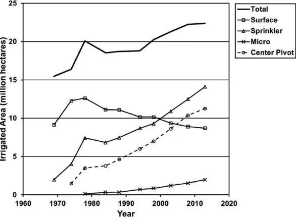
Inter-national Commission on Irrigation and Drainage (ICID), surface irrigation is used on about 85% of the 299 Mha of irrigated cropland in the world (ICID, 2013). India and China each irrigate >60 Mha of cropland (FAO, 2013) and ~95% of this land is surface irrigated (ICID, 2013). The United States and Pakistan each have about 20 Mha of irrigated land. These four counties account for 55% of the irrigated land in the world; all other countries each have <10 Mha of irrigated land. Of these four countries, only the United States uses sprinkler and microirrigation on a signifi
-cant portion of the irrigated cropland. Sprinkler irrigation is used on 57% of the 22 Mha of cropland irrigated in the United States, while microirrigation is used on ~8% of the irrigated cropland, and these percentages continue to increase (Fig. 1). The amount of US farmland irrigated by center pivots has increased almost linearly since they were first marketed in the late 1960s. Center-pivot irrigation in the United States has increased ~240,000 ha yr−1 and is used on 80% of the
sprin-kler-irrigated land and 45% of all irrigated land (USDA-NASS, 2014b).
Available Water Supply
Irrigation water for ~25% of the US irrigated land is supplied by off-farm sources (USDA-NASS, 2014b). The percentage is likely higher in China, India, and Pakistan. Precision irrigation on farms in these irrigation projects must include allowances
for water delivery limitations. Irrigation projects have rules for irrigation water delivery that govern how far in advance a request must be made and whether
the request is for a volume or flow rate for a specified time. In general, irrigation projects are either supply oriented (rigid schedule) or demand oriented (flexible schedule). Some projects may shift from demand-based to supply-based opera -tion as irriga-tion demand increases during the season to a point where irriga-tion
demand exceeds the capacity of the canal system (Lozano and Mateos, 2008). Sup
-ply-oriented systems generally operate canals at constant flow rates to efficiently
et al., 2007). However, this operating method does not account for specific crop irrigation needs in specific fields, which led Merriam et al. (2007) to call sup -ply-oriented delivery an engineer’s dream and a farmer’s nightmare. Clemmens
(2006) referred to supply-oriented delivery as water disposal not irrigation water management. Supply-oriented systems tend to be hydraulically efficient but inef
-ficient for crop water management.
Irrigation projects using supply-oriented schedules may allocate water on
a flow rate per unit area, a volume per unit area, or flow rate for specified time interval. A specific example of a flow-rate allocation project is the Twin Falls Canal Company in southern Idaho. The Twin Falls Canal Company was estab
-lished in 1900 and originally planned to divert 85 m3 s−1 from the Snake River to
irrigate 97,000 ha (Bjorneberg et al., 2008). Since the canal company has a natural-flow water right, irrigation water is continually available at 52 L m−1 ha−1 (total
flow rate divided by total project area) during the entire irrigation season. If flow in the river is not adequate to meet this supply, the allocation per hectare is reduced proportionally to all users. This flow-rate allocation continues today
even though water stored in upstream reservoirs supplements the natural river
flow so the need to reduce allocations is much less. While a flow rate is avail -able during the entire irrigation season, it is not practical to continually use this
flow rate, especially in the spring and fall. In the summer however, the flow rate allocation of 52 L m−1 ha−1 is only 7.5 mm d−1, which does not meet peak irrigation
demand for many crops. Consequently, farmers grow a variety of crops to spread
as the natural-flow water right exists, demonstrating how policies and regula -tions impact irrigation management.
Rigid water allocation policies like the previous example provide little incen -tive for growers to adopt advanced irrigation systems and management practices
such as precision irrigation. On the other hand, flexible irrigation water delivery
strives to match delivery with irrigation demand. This is complicated in large irrigation projects (e.g., >20,000 ha) because it may take one or more days for
water to travel from the diversion point to the field. Changing the flow rate at the main diversion causes a sudden flow-rate change in the canal that dissipates
downstream. Operators further downstream often need to make multiple
adjust-ments to account for the gradual flow-rate change (Clemmens, 2006). Automated diversion gates can be used to maintain desired flow rates within the irrigation project (van Overloop et al., 2010). Bautista et al. (2006) demonstrated a control
system that used pre-established canal hydraulic relationships to make upstream
flow changes to meet downstream delivery changes. Automated control of canal
systems, however, is complicated, requiring excellent measurement and control equipment, good communication systems, and algorithms and strategies for con-trolling the equipment. Implementation usually involves problems that require
adjustments to algorithms and control equipment (Burt and Piao, 2004), but these
problems should not prohibit irrigation projects from implementing advanced control systems.
Flexible water delivery requires adequate canal design to carry and deliver varied flow rates that meet irrigation demand throughout the irrigation system for the entire irrigation season. Canal systems that provide flexible delivery tend
to be more costly to construct and operate than canals designed for supply-based
delivery. Exceeding existing canal flow capacity is an obvious problem. Low irri -gation demand can also be a problem if the canal system requires a minimum
flow rate before water reaches a specific elevation required for water delivery
gates. Additional check structures may be needed to allow water delivery at
lower flow rates. Additional small water storage facilities distributed within the
canal system may also be necessary to store excess water during low demand periods and to more quickly supply water as demand increases.
On-farm water storage also increases irrigation flexibility when off-farm or on-farm water supplies are limited by flow rate or time. Continuous off-farm
water supply can be stored to enable daytime only irrigation or odd irrigation set
times for better surface irrigation management. Pressurized irrigation systems may be able to use off-peak electric supplies by storing water from an off-farm supplier during peak electrical usage time. Farms with low-capacity wells can also benefit from on-farm storage. The low-capacity well can continuously pump water into storage even if the field is not being irrigated as a result of precipitation or field operations. A disadvantage of on-farm storage is that land is taken out of
production for the reservoir, and some water will be lost to evaporation and
seep-age. Producers need to compare the lost production from the reservoir area with
the increased yield from the remaining irrigated land on the farm.
Although applying irrigation when the crop needs water is the best practice,
Schlegel et al. (2012) determined that many irrigation systems cannot meet peak
crop water demands and must rely on stored soil water to meet crop water needs.
They found that preseason irrigation was profitable for wells with 2.5 to 5 mm d−1
was not significantly affected by preseason irrigation. In this case, the soil is the
on-farm storage reservoir.
Crop Water Needs
At the project, farm, and field scales, the first step for precision irrigation is to
know how much water a crop needs at a given time. This is typically done by
cal-culating evapotranspiration (ET), which is the amount of water that evaporates from the soil and plant surfaces and transpires from plants. Evapotranspiration
can be estimated from meteorological data, remotely sensed information (e.g.,
temperature and reflectance), soil water depletion, or crop condition. Precision irrigation requires ET information sufficiently in advance so water can be deliv
-ered (if supplied from an off-farm source) and applied when needed by the crop. At the field scale, irrigation systems typically cannot instantaneously irrigate the
entire field, so allowances must be made for the physical ability to apply water over several days on an individual field. Irrigation system limitations can result in certain parts of the field being overirrigated, while other parts may experience
some level of water stress.
Evapotranspiration
Various methods are available to calculate ET from meteorological data. A common method is the American Society of Civil Engineers’ standardized Penman–Mon
-teith method (Allen et al., 2005), which is used to calculate alfalfa (Medicago sativa L.) reference ET. The reference ET is multiplied by a crop coefficient to estimate ET for a specific crop during the growing season. Crop coefficients can be deter
-mined by methods described in FAO Irrigation and Drainage Paper No. 56 (Allen et al., 1998). Since calculating reference ET and crop coefficients for daily use is cumbersome and time consuming, various ET networks provide crop water use information to users for irrigation scheduling. The US Bureau of Reclamation, for example, has AgriMet, a network of over 70 automatic agricultural weather stations covering irrigated areas in the Pacific Northwest (http://www.usbr.gov/ pn/agrimet/). Similarly, many state networks exist such as California Irrigation Management Information System (CMIS, http://www.cimis.water.ca.gov/), Texas
ET Network (http://texaset.tamu.edu/), and Colorado Agricultural Meteorologi-cal Network (CoAgMet, http://www.coagmet.colostate.edu). It is important to
remember that these networks provide potential ET values for a crop; actual ET could be greater or less depending on local field and crop conditions such as soil, fertility, disease, and precipitation. Specific knowledge about each field, and loca
-tions within fields, is required to precisely irrigate that field. Evett et al. (2012a) noted that crop coefficient values are sensitive to local climate conditions and often are not transferable to other areas. Specific soil or plant monitoring within the field is necessary to determine if net applied irrigation water is meeting or
exceeding actual crop use.
Evapotranspiration can be directly measured using micrometeorological methods such as eddy covariance (e.g., Swinbank, 1951; Twine et al., 2000), Bowen ratio (e.g., Sinclair et al., 1975; Payero et al., 2003), or surface renewal (Paw U et al., 1995; Snyder et al., 2008). Eddy covariance and Bowen ratio methods require care
-ful attention to site conditions and instrument operation. The surface renewal
because sensible heat flux is determined with high frequency air-temperature measurements with fine-wire thermocouples (Mengistu and Savage, 2010). The
disadvantage of surface renewal is the need to calibrate a weighting factor for a
particular plant canopy (Snyder et al., 2008). All three methods require that mea
-surements must be made in areas that represent the field conditions where the
data will be applied, so these methods are not readily applicable for identifying
variable irrigation requirements within a field. Furthermore, Evett et al. (2012b) concluded that it was difficult to estimate ET well using eddy covariance and Bowen ratio even with the best equipment and expert operators.
Soil Water Depletion
A key aspect of precision irrigation is measuring soil water content throughout the crop root zone to quantify the amount of water added to soil by irrigation and precipitation and removed from the soil by crops, evaporation, or deep percola-tion. These measurements can be used to schedule irrigation by applying enough
water to replace water used since the last irrigation. Soil water content may also be used to verify and reset irrigation scheduling models that are based on ET
estimations. A variety of direct and indirect methods can be used to measure soil
water content. Direct measurement involves collecting a soil sample of known
volume, determining the mass of the sample, drying the sample, and
determin-ing the mass of the dry sample. Direct measurement is highly accurate but time
consuming, so it is mainly used to verify or calibrate indirect measurement meth-ods rather than monitor soil moisture conditions for irrigation scheduling.
Indirect methods include neutron moisture meter and various sensors that use electromagnetic methods. The neutron moisture meter is an accurate method
for repeated measurements of soil profile water content (Evett and Steiner, 1995). However, measurements cannot be automated, and a permit is required for the
radiation source in the meter so neutron moisture meters have seen limited use
beyond research. Time domain reflectometry is another indirect method of mea
-suring soil water content that has been shown to be accurate and repeatable (Evett, 1998; Herkelrath et al., 1991). A variety of other electromagnetic sensors are now available for measuring soil water content. Evett et al. (2009) compared three
capacitance-type sensors with neutron moisture meter and gravimetric
measure-ments. Spatial variations of measured soil water profiles were similar between
the neutron moisture meter and gravimetric methods. The electromagnetic sen-sors, however, had greater variability and were relatively inaccurate even though
soil-specific calibrations were used. Evett et al. (2012b) found that capacitance sen
-sors used in access tubes had soil water content errors up to 0.05 m3 m−3, which
implied errors in soil water flux estimation of up to 50 mm d−1. They concluded
that capacitance-based soil water sensing was not suited to accurate
measure-ment primarily because the electromagnetic field does not uniformly permeate the soil around the access tube in structured soils. For accurate determination of ET and crop water production, they recommended using neutron probe, gravi
-metric sampling, or conventional time domain reflectometry methods.
Soil water potential can be measured in addition to soil water content. Soil
scheduling irrigation. Various instruments are available to directly or indirectly measure soil water potential. Tensiometers have been used for the last 100 yr (Or, 2001) to directly measure soil water potential. The original measurement device
on tensiometers was a mercury manometer, then bourdon-type gauges, and now digital pressure sensors can be used to continuously and remotely measure soil water potential. Two common indirect measurement devices are gypsum blocks and granular matrix sensors, which measure soil water potential over
a wider range than tensiometers. Both sensors have porous material that loses water as the soil dries and gains water as the soil becomes wetter. While gypsum blocks are relatively inexpensive, they are better suited to measure relative soil
water changes to determine when to irrigate rather than determining irrigation amounts. If properly calibrated, granular matrix sensors indicate trends that can be used for irrigation scheduling.
Remote Sensing to Determine Crop Water Needs
Remote sensing can be used to determine crop water use at project, farm, and field scales. Satellite-based remote sensing has advanced to where submeter resolu
-tion and daily coverage are possible with many defined spectral indices available besides normalized difference vegetation index (Mulla, 2013). Sensors are also
available to mount on tractors, sprayers, or moving irrigation systems to provide real-time information. The same remote sensing technologies and management can be applied on irrigated farms and nonirrigated farms with the obvious excep-tion that remote sensing can inform and guide water applicaexcep-tion decisions for irrigated farms. Irrigation also allows fertilizer or other chemicals to be applied during the growing season when ground-based applicators will damage the crop. Remote sensing is useful for systematic measurements with time over large
areas (Bastiaanssen et al., 2000). Jackson et al. (1977) first related the difference between canopy temperature and air temperature to ET. Satellite or aerial remote sensing can provide repeated field observations for an entire irrigation project
that can be used in models to guide diversions of irrigation water or identify
vari-ations within fields. Remote sensing can also identify the actual irrigated area of specific crops within an irrigation project so managers can better plan diversions to match crop water needs. Michael and Bastiaanssen (2000) developed a tech
-nique to define crop coefficient maps from satellite images. Total crop water use for an irrigated area can then be calculated by multiplying reference ET by the crop coefficient. SEBAL (Bastiaanssen et al., 1998), METRIC (Allen et al., 2007), and ALEXI (Anderson et al., 2012) are energy balance models that use thermal infrared imagery for estimating ET for large areas. The Surface Energy Balance Algorithm for Land (SEBAL) model describes the spatial variability of most micrometeoro
-logical variables with semiempirical functions. SEBAL can be applied for diverse
agroecosystems and does not require ancillary information on land use or crop
types (Bastiaanssen et al., 1998). Validation efforts have shown that the error at a 1-ha scale varies between 10 and 20% and that the uncertainty diminishes with increasing scale. For an area of 1000 ha, the error is reduced to 5% and for regions of 1 million ha of farmland, the error becomes negligibly small (Bastiaanssen et al., 2000). Mapping EvapoTranspiration at High Resolution and Internalized Calibration (METRIC) uses the same basic energy balance algorithms as SEBAL to calculate ET from satellite imagery (Allen et al., 2007, 2011). However, MET
between instantaneous satellite images. The Atmosphere-Land Exchange Inverse (ALEXI) model (Anderson et al., 1997; Mecikalski et al., 1999) was developed as an auxiliary means for estimating surface fluxes over large regions using primarily remote-sensing data. This flux model is unique in that no information regarding
antecedent precipitation or moisture storage capacity is required because the sur-face moisture status is deduced from a radiometric temperature change signal.
Therefore, ALEXI can provide independent information for updating soil mois
-ture variables in more complex regional models. However, these models require significant processing time, so real-time daily ET estimates are not available.
Direct ET measurements like eddy covariance, Bowen ratio, and surface renewal do not provide information about spatial variability within a field. Satel -lite and air-based remote sensing provide spatial information, but measurement
intervals are usually >1 d. Combining direct or reference ET measurements
from micrometeorological methods with remotely sensed spatial information
can provide daily, site-specific ET information within fields. Jackson et al. (1977) developed a technique to calculate daily ET from one-time-of-day measurements. Peters and Evett (2004) used one-time-of-day measurements with a reference temperature curve from a fixed location to model diurnal canopy temperature dynamics within a field. Ben Asher et al. (2013) combined the Penman–Monte
-ith ET equations w-ith infrared radiometers mounted on a linear-move irrigation system to calculate hourly ET to control an irrigation system without monitoring soil water. This system provided a bulk representation of the field not site-specific information within the field. Remotely sensed thermal and reflectance informa
-tion from the crop canopy can be used to calculate site-specific water use. Colaizzi et al. (2012) used a two-source energy balance model to predict daily ET of corn, cotton (Gossypium hirsutum L.), grain sorghum [Sorghum bicolor (L.) Moench], and wheat. Their technique may allow the center pivot to be the remote sensing
plat-form for collecting real-time inplat-formation for calculating site-specific ET.
Field-Scale Precision Irrigation
For at least the last 50 yr, irrigation research has attempted to understand crop water needs and to apply water uniformly to fields. Good irrigation management should strive to optimize crop yield in a field. When irrigation is not uniform,
some areas receive more water than required and some areas receive less. To
reduce the assumed negative effects of too little irrigation, operators may apply additional water to the entire field, which means a larger portion of the field is overirrigated and may actually reduce total crop yield from the field. Soils are seldom uniform within a field, indicating that infiltration rates and potential crop yields will also vary within a field. Although modern center-pivot irriga
-tion systems uniformly apply irriga-tion water, water will not uniformly infiltrate
if soil properties are not uniform. Uniformly applied irrigation water, or
rain-fall, that runs off and infiltrates in another area in the field leads to nonuniform infiltration. This in-field runoff causes variations in stored soil water, which in
turn causes variable irrigation requirements. Couple this with variable
of site-specific sprinkler irrigation to conserve water or energy on a field scale (Evans and King, 2012).
Center-pivot and linear-move sprinkler irrigation systems are well suited to precision irrigation management. These moving irrigation systems can be designed
and controlled to apply different rates of water on different locations in the field. Solid set or permanent sprinkler irrigation systems, including microirrigation, can also be designed to differentially apply water. Since these systems do not move,
sprinkler application rates can be permanently or seasonally adjusted by changing
sprinklers or nozzles to meet water needs for specific areas. Varying the duration
of irrigation events among management zones can also be used provided that the
irrigation zones match the field variability. Set-move irrigation systems (e.g.,
side-roll systems) can apply variable amounts of water if sprinkler nozzles vary along the system or are changed between irrigation sets. At this time, this would require
extensive manual labor. Varying application rates to precisely meet irrigation requirements within a field is nearly impossible with surface irrigation because water flows by gravity on the soil surface through the field. Individual basins, bor
-ders, or furrows can be irrigated for different time intervals, but application depth cannot be controlled spatially within these units. Even if surface irrigation could
be controlled to spatially vary water application, the irrigator would need to know
how much water will infiltrate in a specific time period (through measurement or
models) to precisely apply the right amount of water in the right location.
Moving sprinkler irrigation systems, like center-pivot and linear-move
irri-gation systems, are probably the most appropriate platform for SSIM in crop fields. Center-pivot irrigation systems mechanically move through the entire field multiple times per year enabling irrigation amounts and rates to vary within
the season and between seasons. Technology for controlling center-pivot
opera-tion is continually changing from the original on–off switch and speed control
dial. Operators can now communicate with irrigation machines by cell phones,
satellite radios, and internet-based systems (Kranz et al., 2012). Center-pivot manufactures now offer control panels that can change pivot speed in 1 to 10° increments (Evans et al., 2013). Controlling center-pivot speed allows the operator to change application depth in pie-shaped areas within fields; however, field vari -ability seldom occurs in triangular-shaped parcels. Center-pivot manufacturers
also offer variable-rate irrigation systems that can change application rates along the lateral by pulsing individual or groups of sprinklers on and off. Using vari
-able speed and rate en-ables a field to be divided into several thousand parcels to accurately match the management zones within a field.
Although center-pivot irrigation systems are commercially available to
pre-cisely apply water to management zones within a field, user-friendly systems to manage SSIM are not. To fully implement SSIM, sensor systems are needed to
measure crop, soil, and weather factors so the plants and soil control the amount
and timing of irrigation in each zone in the field. Within-season temporal varia
-tion in rainfall, infiltra-tion, and water use require periodic feedback of plant and
soil status. Temporal feedback can be used for real-time irrigation management and improved decision support.
Most current irrigation scheduling programs calculate the timing and
dura-tion of water applicadura-tions using algorithms based on historical weather patterns and predicted crop water use over a relatively short period (e.g., 3–14 d). Feedback
other data after the irrigation is completed, and adjustments are made for the
fol-lowing irrigation event. Specialized software programs need to be developed for SSIM so that data obtained from multiple sources can be used to determine the amount and timing of irrigation for each zone in a field.
Recent innovations in low-voltage sensors and wireless radio frequency data
communications combined with advances in internet technologies offer tremen
-dous opportunities for advancement of SSIM. Spatially distributed, within-field
plant and soil sensors in combination with agroweather stations are potentially more accurate for controlling irrigation than historical or static map-based input
projections. Sensor systems can be used to measure climatic, soil water, plant den
-sity, canopy temperature differences, irrigation application amounts, and other
types of variability. Remote sensing by satellites can also provide synoptic crop feedback in both space and time to supplement real-time measurements. Real-time feedback from multiple sources, in combination with modern wireless communi-cation and computerized control systems, are fundamental to the development and
implementation of optimal site-specific irrigation management strategies.
Moving irrigation systems provide a unique platform to collect data from
sensors in the field in addition to applying irrigation water. O’Shaughnessy and Evett (2010) demonstrated that wireless infrared thermometers functioned reli
-ably when mounted on a center-pivot irrigation system. Peters and Evett (2008)
used infrared temperature to automate irrigation with a center pivot. There was
no difference in irrigation efficiency or water use efficiency compared with man -ual irrigation scheduling using a neutron probe to measure soil water content.
This system used the temperature–time threshold method (Wanjura et al., 1995)
to determine when irrigation was required. The center pivot traveled through the
field each day to measure canopy temperature. If a threshold canopy temperature
is exceeded for a predetermined threshold time, an irrigation event is scheduled.
Presently, there has been limited adoption of site-specific irrigation systems.
One estimate is that there are <200 center-pivot systems with variable-rate
tech-nology in the United States (Evans et al., 2013). One reason for limited adoption
is that variable-rate irrigation technology has only recently been commercially marketed by center-pivot system manufacturers. Another potential barrier to installing variable-rate irrigation technology is the current limited use of soil
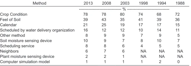
or plant sensing to schedule irrigation. The USDA Farm and Ranch Irrigation Survey showed that <10% of irrigated farms used soil or plant sensing or a sched
-uling service (Table 2). Furthermore, the trend is not increasing for any of these
technologies. These results indicate that acceptable technology is currently not available, or the need for more sophisticated scheduling has not been realized by
irrigators. In addition to demonstrating the benefits of SSIM, reliable, easy-to-use equipment is needed for large-scale adoption of SSIM. The common use of yield
monitors in today’s harvesting equipment allows farmers to see the variability in
their fields and may increase interest in spatially varying irrigation.
Integrating information from various sensors and systems into a decision support program will be critical to highly managed, spatially varied irrigation
(Evans and King, 2012). Advanced decision systems should integrate real-time
monitoring with plant growth and pest models to seamlessly interface with the
irrigation system to optimally manage crop production. For example, the best response to an identified diseased area in a field may be a pesticide treatment
water supply can be saved for healthy areas of the field. Advanced decision sys -tems also need to consider the whole farm to best use water and other resources
among multiple fields, crops, and even years. For example, if groundwater use
for irrigation is limited to 400 mm yr−1 on a 3-yr average, using <400 mm in 1 yr
allows an irrigator to use >400 mm in future years.
Summary
Precision irrigation involves applying the right amount of water at the right time and location. Precision irrigation management is needed on large irrigation proj
-ects and on individual fields to make the best use of irrigation water, especially
in water-limited areas. On large irrigation projects, managers need to adjust irrigation delivery to match the irrigation needs of the crops in the project. On
individual farms and fields, managers need specific information about crop water needs on their fields to apply the right amount of water at the right time and place.
Technology is commercially available to precisely apply water when and where it is needed by crops; however, user-friendly decision tools are still needed
to quantify specific irrigation needs and control water application within fields.
Researchers and managers need to remember that the technology to precisely
apply irrigation water is wasted if the water does not infiltrate where it was
applied. Irrigation system design must consider soil properties along with irriga-tion capacity.
Satellite imagery can be used to calculate actual crop water use in fields, but
this information is not available in real-time for daily irrigation management.
Combining direct or reference ET measurements from micrometeorological
methods with remotely sensed spatial information can provide daily,
site-spe-cific ET information within fields. Unmanned aerial vehicles are a developing
technology that may make it feasible to collect frequent, high-resolution aerial imagery for managing irrigation. An alternative to satellite-based remote sensing
is in-field sensors that provide information to a decision support system to pre
-cisely manage field irrigation. Integrating information from various sensors into
a decision support program is the next potential advancement to precisely apply
the right amount of water at the right time to unique areas within a field. Table 2. Percent of farms reporting a method of deciding when to irrigate. Respon-dents could select more than one method (USDA NASS, 2014b).
Method 2013 2008 2003 1998 1994 1988
%
---Crop Condition 78 78 80 74 68 72
Feel of Soil 39 43 35 41 39 36
Calendar 21 25 19 17 17 15
Scheduled by water delivery organization 16 12 12 10 14 11
Other method 8 9 9 7 9 5
Soil moisture sensing device 10 9 7 8 10 7
Scheduling service 8 8 6 4 5 5
Neighbors 6 7 6 NA NA NA
Plant moisture sensing device 2 2 1 NA NA NA
Water rights and policies can be a barrier to adopting precision irrigation
practices by restricting water delivery amounts or timing at the district or field level. However, irrigation managers and designers can partially account for these
restrictions through on-farm storage, irrigation system design, or crop choice, allowing the right amount of water to be applied at the right time and place.
References
Allen, R.G., A. Irmak, R. Trezza, J.M.H. Hendrickx, W. Bastiaanssen, and J. Kjaersgaard. 2011. Satellite-based ET estimation in agriculture using SEBAL and METRIC. Hydrol. Processes 25:4011–4027. doi:10.1002/hyp.8408
Allen, R.G., L.S.Pereira, D. Raes, and M. Smith. 1998. Crop evapotranspiration: Guidelines for computing crop water requirements. FAO Irrigation and Drainage Paper No. 56. Food and Agric. Org. of the United Nations, Rome.
Allen, R.G., M. Tasumi, and R. Trezza. 2007. Satellite-based energy balance for mapping evapotranspiration with internalized calibration (METRIC)–model. J. Irrig. Drain. Div., Am. Soc. Civ. Eng. ASCE133:380–394. doi:10.1061/(ASCE)0733-9437(2007)133:4(380) Allen, R.G., I.A. Walter, R.L. Elliott, T.A. Howell, D.Itenfisu, M.E.Jensen, and R.L. Snyder.
2005. ASCE standardized reference evapotranspiration equation.Am. Soc. of Civil Engineers, Reston, VA.
Anderson, M.C., W.P. Kustas, J.G. Alfieri, F. Gao, C. Hain, J.H. Prueger, S. Evett, P. Colaizzi, T. Howell, and J.L. Chavez. 2012. Mapping daily evapotranspiration at Landsat spa -tial scales during the BEAREX’08 field campaign. Adv. Water Resour. 50:162–177. doi:10.1016/j.advwatres.2012.06.005
Anderson M.C., J.M.Norman, G.R. Diak, W.P. Kustas, and J.R. Mecikalski. 1997. A two-source time-integrated model for estimating surface fluxes using thermal infrared remote sensing. Remote Sens. Environ. 60:195–216. doi:10.1016/S0034-4257(96)00215-5 Bastiaanssen, W.G.M., M. Menenti, R.A. Feddes, and A.A.M. Holtslag. 1998. A remote sens
-ing surface energy balance algorithm for land (SEBAL), part 1. Formulation. J. Hydrol. 212–213:198–213. doi:10.1016/S0022-1694(98)00253-4
Bastiaanssen, W.G.M., D.J. Molden, and I.W. Makin. 2000. Remote sensing for irrigated agriculture: Examples from research and possible applications. Agric. Water Manage. 46:137–155. doi:10.1016/S0378-3774(00)00080-9
Bautista, E., A.J. Clemmens, and R.J. Strand. 2006. Salt River Project canal automa -tion pilot project: Simula-tion tests. J. Irrig. Drain. Eng. 132:143–152. doi:10.1061/ (ASCE)0733-9437(2006)132:2(143)
Ben Asher, J., B.B. Yosef, and R. Volinsky. 2013. Ground-based remote sensing sys -tem for irrigation scheduling. Biosys-tems Eng. 114:444–453. doi:10.1016/j. biosystemseng.2012.09.002
Bjorneberg, D.L., D.T. Westermann, N.O. Nelson, and J.H. Kendrick. 2008. Conservation practice effectiveness in the irrigated Upper Snake/Rock Creek Watershed. J. Soil Water Conserv. 63:487–495. doi:10.2489/jswc.63.6.487
Burt, C.M., and X.Piao. 2004. Advances in PLC-based irrigation canal automation. Irrig. Drain.53:29–37. doi:10.1002/ird.106
Clemmens, A.J.2006. Improving irrigated agriculture performance through an under-standing of the water delivery process. Irrig. Drain.55:223–234. doi:10.1002/ird.236 Colaizzi, P.D., S.R. Evett, T.A. Howell, P.H.Gowda, S.A.O’Shaughnessy, J.A. Tolk, W.P.
Kustas, and M.C. Anderson. 2012. Two-source energy balance model: Refine -ments and lysimeter tests in the Southern High Plains. Trans. ASABE55:551–562. doi:10.13031/2013.41385
Evans, R.G., and B.A. King. 2012. Site-specific sprinkler irrigation in a water-limited future. Trans. ASABE55:493–504. doi:10.13031/2013.41382
Evett, S.R. 1998. Coaxial multiplexer for time domain reflectometry measurement of soil water content and bulk electrical conductivity. Trans. ASAE 41:361–369. doi:10.13031/2013.17186
Evett, S.R., R.J. Lascano, T.A. Howell, J.A. Tolk, S.A.O’Shaughnessy, and P.D. Colaizzi. 2012a. Single- and dual-surface iterative energy balance solutions for reference ET. Trans. ASABE55:533–541. doi:10.13031/2013.41388
Evett, S.R., R.C. Schwartz, J.J. Casanova, and L.K. Heng. 2012b. Soil water sensing for water balance ET and WUE. Agric. Water Manag. 104:1–9. doi:10.1016/j.agwat.2011.12.002 Evett, S.R., R.C. Schwartz, J.A. Tolk, and T.A. Howell. 2009. Soil profile water content deter
-mination: Spatiotemporal variability of electromagnetic and neutron probe sensors in access tubes. Vadose Zone J. 8:926–941. doi:10.2136/vzj2008.0146
Evett, S.R., and J.L.Steiner. 1995. Precision of neutron scattering and capacitance type soil water content gauges from field calibration. Soil Sci. Soc. Am. J.59:961–968. doi:10.2136/ sssaj1995.03615995005900040001x
FAO. 2013. AQUASTAT database. Food and Agriculture Organization of the United Nations (FAO), Rome. www.fao.org/nr/water/aquastat/main/index.stm (accessed 20 Apr. 2013). Herkelrath, W.N., S.P. Hamburg, and F. Murphy. 1991. Automatic, real-time monitoring of soil moisture in a remote field area with time domain reflectometry. Water Resour. Res. 27:857–864. doi:10.1029/91WR00311
Holmen, H., C.W. Carlson, R.J. Lorenz, and M.E. Jensen. 1961. Evapotranspiration as affected by moisture level, nitrogen fertilization, and harvest method. Trans. ASAE 4:41–44. doi:10.13031/2013.41004
International Commission on Irrigation and Drainage (ICID). 2013. ICID databaase. ICID, Chanakyapuri, New Delhi. www.icid.org/icid_data.html (accessed 20 Apr. 2013) Jackson, R.D., R.J. Reginato, and S.B. Idso. 1977. Wheat canopy temperature: A practical
tool for evaluating water requirements. Water Resour. Res. 13:651–656. doi:10.1029/ WR013i003p00651
Kranz, W.L., R.G. Evans, and F.R. Lamm. 2012. A review of center-pivot irrigation control and automation technologies. Applied Eng. in Agric. 28:389–397. doi:10.13031/2013.41494 Lenka, S., A.K. Singh, and N.K. Lenka. 2009. Water and nitrogen interaction on soil pro
-file water extraction and ET in maize–wheat cropping system. Agric. Water Manage. 96:195–207. doi:10.1016/j.agwat.2008.06.014
Lozano, D., and L. Mateos. 2008. Usefulness and limitations of decision support systems for improving irrigation scheme management. Ag. Waste Manag. 95:409–418.
Maupin, M.A., J.F. Kenny, S.S. Hutson, J.K. Lovelace, N.L. Barber, and K.S. Linsey. 2014. Esti -mated use of water in the United States in 2010. U.S. Geological Survey Circular 1405. U.S. Dep. of the Interior, Washington, DC.
Mecikalski, J.R., G.R. Diak, M.C. Anderson, and J.M. Norman, 1999. Estimating fluxes on continental scales using remotely-sensed data in an atmospheric-land exchange model, J. Appl. Meteorol. 38:1352–1369. doi:10.1175/1520-0450(1999)038<1352:EFOCSU >2.0.CO;2
Mengistu, M.G., and M.J. Savage. 2010. Surface renewal method for estimating sensible heat flux. Water S.A. 36:9–17. doi:10.4314/wsa.v36i1.50902
Merriam, J.L., S.W.Styles, and B.J.Freeman. 2007. Flexible irrigation systems: Concept, design and application. J. Irrig. Drain. Eng.133:2–11. doi:10.1061/(ASCE)0733-9437(2007)133:1(2) Michael, M.G., and W.G.M. Bastiaanssen. 2000. A new simple method to determine crop coefficients for water allocation planning from satellites: results from Kenya. Irr. Drain. Sys. 14:237–256. doi:10.1023/A:1026507916353
Mulla, D.J. 2013. Twenty five years of remote sensing in precision agriculture: Key advances and remaining knowledge gaps. Biosystems Eng. 114:358–371. doi:10.1016/j. biosystemseng.2012.08.009
O’Shaughnessy, S.A., and S.R.Evett. 2010. Developing wireless sensor networks for moni -toring crop canopy temperature using a moving sprinkler system as a platform. Appl. Eng. Agric.26:331–341. doi:10.13031/2013.29534
Pandey, R.K., J.W. Maranville, and A. Admou. 2000. Deficit irrigation and nitrogen effects on maize in a Sahelian environment I. Grain yield and yield components. Agric. Water Manage. 46:1–13. doi:10.1016/S0378-3774(00)00073-1
Paw U, K.T., J. Qiu, H.B. Su, T. Watanabe, and Y. Brunet. 1995. Surface renewal analysis: A new method to obtain scalar fluxes without velocity data. Agric. For. Meteorol.74:119–137. doi:10.1016/0168-1923(94)02182-J
Payero, J.O., C.M.U. Neale, J.L. Wright, and R.G. Allen. 2003. Guidelines for validating Bowen ratio data. Trans. ASAE46:1051–1060. doi:10.13031/2013.13967
Peters, R.T., and S.R.Evett. 2004. Modeling diurnal canopy temperature dynamics using one-time-of-day measurements and a reference temperature curve. Agron. J.96:1553– 1561. doi:10.2134/agronj2004.1553
Peters, R.T., and S.R.Evett. 2008. Automation of a center pivot using the temperature-time-threshold method of irrigation scheduling. J. Irrig. Drain. Eng.134:286–291. doi:10.1061/ (ASCE)0733-9437(2008)134:3(286)
Sadler, E.J., C.R. Camp, D.E. Evans, and J.A. Millen. 2002. Spatial variation of corn response to irrigation. Trans. ASAE 45:1869–1881. doi:10.13031/2013.11438
Schlegel, A.J., L.R. Stone, T.J. Dumler, and F.R. Lamm. 2012. Managing diminished irriga -tion capacity with reseason irriga-tion and plant density for corn produc-tion. Trans. ASABE 55:525–531. doi:10.13031/2013.41394
Sinclair, T.R., L.H. Allen, and E.R. Lemon. 1975. Analysis of errors in the calculation of energy flux densities above vegetation by a Bowen ratio profile method. Boundary-Layer Meteorol. 8:129–139. doi:10.1007/BF00241333
Snyder, R.L., D.Spano, P.Duce, K.T. Paw U, and M. Rivera. 2008. Surface renewal esti -mation of pasture evapotranspiration. J. Irrig. Drain. Eng.134:716–721. doi:10.1061/ (ASCE)0733-9437(2008)134:6(716)
Swinbank, W.C. 1951. The measurement of vertical transfer of heat and water vapor by eddies in the lower atmosphere. J. Meteorol. 8:135–145. doi:10.1175/1520-0469(1951)008<0135:TMO VTO>2.0.CO;2
Twine, T.E., W.P. Kustas, J.M. Norman, D.R. Cook, P.R.Houser, T.P. Meyers, J.H.Prueger, P.J. Starks, and M.L. Wesely. 2000. Correcting eddy-covariance flux underestimates over a grassland. Agric. For. Meteorol.103:279–300. doi:10.1016/S0168-1923(00)00123-4 USDA-NASS. 2014a. Census of Agriculture. USDA National Agricultural Statistics Service.
Washington, DC. http://www.agcensus.usda.gov/ (accessed 17 May 2016).
USDA-NASS. 2014b. Farm and ranch irrigation survey. USDA National Agricultural Sta -tistics Service, Washington, DC. https://www.agcensus.usda.gov/Publications/2012/ Online_Resources/Farm_and_Ranch_Irrigation_Survey/ (accessed 17 May 2016). van Overloop, P.J., A.J. Clemmens, R.J.Strand, R.M.J. Wagemaker, and E.Bautista. 2010.
Real-time implementation of model predictive control on Maricopa-Stanfield Irriga -tion and Drainage District’s WM canal. J. Irrig. Drain. Eng.136:747–756. doi:10.1061/ (ASCE)IR.1943-4774.0000256