Earth As A Dynamic System
Notables in the Image
• Swirling clouds
• Dominance of ocean environment
• Rift system of Red Sea • Large Southern Ice Cap
(Antarctica)
• Cyclonic Storms
Major Concepts
• Surface features are record of Dynamics
• Motion of water and wind modify the Earth • Continents and ocean basins are principal
surface features
• Earth is a differentiated planet: Density Stratification
Dynamics and Time: An Ancient Earth
• Changes occur
slowly but sufficient time has passed such that the Earth is very different from its
Evidence for an Ancient Earth
• Angular unconformity -
layers of rock or sediment that exist at different angles to each other.
Process
1. Initial sedimentation
2. Deformation & folding
3. Erosion on folded layer
Evidence for an Ancient Earth
Nonconformity - Sedimentary rock over eroded metamorphic or intrusive igneous rocks.
Evidence for Ancient Earth
• Salinity of ocean - from accumulated eroded minerals/ions
• Temperature of Earth
• Sedimentation - rates of and sediment thickness
• Fossils - Relative Dating
An Old Earth - What’s the Big Deal?
An Old Earth means that:
1. Sufficient time has passed for Evolution of species.
2. The Earth’s structure is not constant.
3. The Earth’s structure is dynamic.
Earth’s Interior Is Layered Inside
Density is a key concept for understanding the structure of Earth.
Density measures the mass per unit volume of a substance.
Density = _Mass_
Volume
Density is expressed as grams per cubic centimeter.
Three spheres surround the rocky portion of the Earth
• Hydrosphere includes all of the “free” water of the Earth contained in:
– Oceans – Lakes – Rivers – Snow – Ice
– Water vapor – Groundwater
Three spheres surround the rocky portion of the Earth (continued)
• Atmosphere is the gaseous envelope that
surrounds the Earth .
– It is mainly a mixture of nitrogen and oxygen.
• Biosphere refers to all living and non-living
• Earth consists of a series of concentric layers or
spheres which differ in chemistry and physical properties.
• The compositional layers of the Earth are:
• the Crust • the Mantle • the Core
• The Core is subdivided into a molten outer core and solid inner core
Earth’s Inner Structure Was Gradually Revealed
A cross section through Earth showing the internal layers.
Note: in the expanded section the
relationship between lithosphere and asthenosphere, and between crust and mantle.
The thin oceanic crust is primarily basalt, a heavy dark-colored rock.
The thicker continental crust is granite, a speckled rock.
The mantle is thought to consist mainly of oxygen, iron, magnesium, and silicon.
Physical state is determined by the combined effects of pressure and temperature
• Increasing pressure raises the melting point of a material.
Earth’s Layers May Be Classified by Physical Properties
Note that Earth is density stratified, that is, each deeper layer is denser than the layer above.
Composed primarily of iron Density = 13 g/cm3
Core
Composed of silicon, oxygen, iron, and magnesium Density = 4.5 g/cm3
Mantle
Composed primarily of basalt (Si, O, Mg) Density = 2.9 g/cm3
Oceanic Crust
Composed primarily of granite (Si, O, Al) Density = 2.7 g/cm3
Continental Crust
Earth’s Layers May Be Classified by Composition
When we examine the chemical and physical properties of Earth’s layers, we see that a
cool, rigid, less dense layer (the lithosphere) floats on a hot, slowly-flowing, more dense layer (the asthenosphere).
Solid, very dense and extremely hot Inner Core
Dense, viscous liquid layer, extremely hot Outer Core
Denser and more slowly flowing than the
asthenosphere (hot, but pressure means not melted) Mantle
(Extends to core)
Hot, partially melted layer of upper mantle which flows slowly
Asthenosphere (350-650 km)
Cool, rigid, outer layer
(includes crust, upper mantle) Lithosphere
(100-200 km)
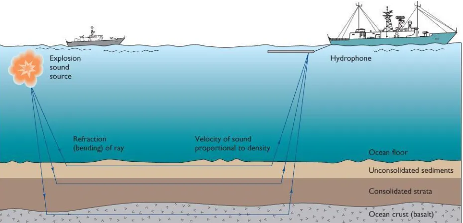
• Seismic refraction examines how sound waves are bent (refracted) as they travel through material.
• They reveal: – Densities – Depths
– Thicknesses of rock layers
2-4 Altimetry
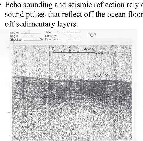
• Echo sounding and seismic reflection rely on sound pulses that reflect off the ocean floor and off sedimentary layers.
2-4 Altimetry
Seismology
• Seismic waves move through Earth from Epicenter of Earthquake • P waves are
compressional, rapid, move through outer core. • S waves are transverse,
can’t move through the outer core.
• Both waves are refracted as density changes.
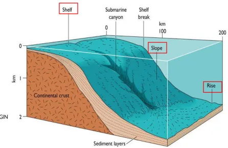
Continents and ocean basins differ in composition, elevation and physiographic features
• Elevation of Earth’s surface displays a bimodal distribution.
About 29% above sea level
Much of the remainder 4-5 kilometers below sea level
• Continental margins are the submerged edges of the
continents and consist of massive wedges of sediment eroded from the land and deposited along the continental edge.
• The continental margin can be divided into three parts:
the Continental shelf the Continental slope the Continental rise
• Continental crust is mainly composed of granite.
– light colored
– lower density (2.7 gm/cm3) – igneous rock
– rich in aluminum, silicon and oxygen
• Oceanic crust is composed of basalt
– dark colored
– higher density (2.9 gm/cm3) – volcanic rock
– rich in silicon, oxygen and magnesium
• The Moho is the boundary between rocks of the crust and the denser (3.3 gm/cm3) rocks of the mantle.
• Isostasy refers to the balance of an object “floating” upon a fluid medium.
• Height of the mass above and below the surface of the medium is controlled by:
– the thickness of the mass
– the density of the mass (similar to ice floating in water).
(Right) The concept of buoyancy is illustrated by a ship on the ocean. The ship sinks until it displaces a volume of water equal to the weight of the ship and its cargo.
Icebergs sink into water so that the same proportion of their volume (about 90%) is submerged. The more massive the iceberg, the greater this volume is.
Isostatic Equilibrium Supports Continents above Sea Level
Think for a moment about the lithosphere. Why doesn’t it sink into the asthenosphere? How are features such as mountains supported?
Isostasy
• Continents are thick (30 to 40 km), have low density and rise high above the supporting mantle rocks.
• Sea floor is thin (4 to 10 km), has greater density and does not rise as high above the mantle. It extends for about 60,000 km around the Earth.
Plate Tectonics
• Alfred Wegener proposed his hypothesis (in 1912) of continental drift based upon
– the fit of continental outlines – fossil evidence
– geologic evidence
• Additional Evidence
– Paleomagnetism
The continents are sections of a past super continent called Pangaea. Pangaea broke apart and the
The Breakup of Pangaea
Continental Drift
The Breakup of Pangaea How are spreading
Continent/Ocean Plate Formation
• Lithosphere cracks - molten basalt rises • Rift opens - ocean
basin forms between • Water fills in, ocean
spreads below
Model of spreading - can be seen in
Red Sea - example of new ocean basin
Gulf of Arabia
Red Sea Gulf of Suez
Dead Sea Rift
Med. Sea
The Red Sea is an example of a rift, and what happened to Pangaea. As the African plate moves away from the Arabian plate a rift is formed and water invades. The rift extends up the Red Sea and splits at its northern end - one branch forms the Gulf of
Suez and the other extends up the gulf of Arabia.
Movement of the Arabian plate away from Africa
-Plate edges are trenches, oceanic ridges and transform faults.
-We can see effects of continental drift in real time where the plates collide
-Subduction & mountain building at convergent plates
-Rifts at divergent plates
- Earthquakes!
How do the plates move?
Convection in the asthenosphere drags
Earthquakes are concentrated along oceanic ridges, transform faults, trenches and island arcs
Global Plate Tectonics
Plate Boundaries - 3 Types
1. Divergent - parting causes splitting
2. Convergent - colliding causes buckling
• Because Earth’s size has not changed, expansion of the crust in one area requires destruction of the crust
elsewhere.
• Currently, the Pacific Ocean basin is shrinking as other ocean basins expand.
• Seismicity is the frequency, magnitude and distribution of earthquakes.
• Tectonism refers to the deformation of Earth’s crust.
Continental and Oceanic Plate Collision
• Formation of island arc along trench as two plates converge.
Continental mountains indicate that
compressional forces are squeezing the land together.
Crustal Motions
Mountain Building
• Destruction of sea floor occurs in
subduction zones.
• Subduction is the process at a trench
whereby one part of the sea floor plunges below another plate and down into the
asthenosphere.
• Benioff Zone is an area of increasingly deeper seismic activity associated with subduction.
• It is inclined from the trench downward, toward the deep-sea trench and away from the island arc.
Global Plate Tectonics
Age of the Ocean Crust
• Sea floor spreading demonstrates that:
– the sea floor moves apart at the oceanic ridges – new oceanic crust is added to the edges
• Rift valleys along oceanic ridge crests:
– indicate tension
– are bounded by normal faults (where crustal rocks have broken and dropped past each other…forming a valley)
– are floored by recently-erupted basaltic lava flows
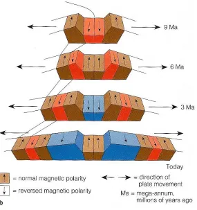
The geomagnetic field is the magnetic field of the Earth.
• Magnetometers detect and measure Earth’s
magnetic field.
• Moving across the ocean floor
perpendicularly to the oceanic ridges, magnetometers record magnetic
measurements.
• These measurements (called magnetic
anomalies) alternate
strong (positive) and
weak (negative) in
response to the influence of the sea floor rocks.
• Magnetic anomalies form parallel bands arranged symmetrically about the axis of the oceanic ridge.
Sea-Floor Spreading
Paleomagnetism
• Bands of differing polarities in the
spreading sea-floor - represent changing polarity of the Earth AND indicate age of the Earth.
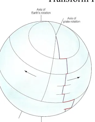
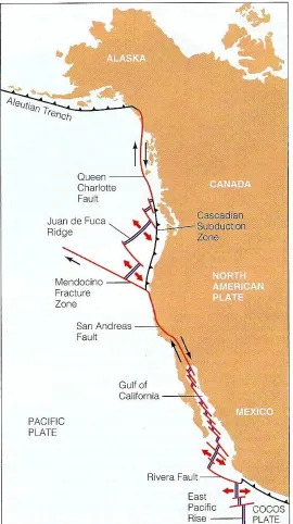
Transform Plate Boundaries
• Transform faults form
because axis of
seafloor is spreading on a sphere. A line can’t be followed.
Axis of the oceanic ridge is offset by
transform (strike-slip) faults which produce lateral displacement.
Sea-Floor Spreading
Crustal Motions
The San Andreas Fault is a transform fault. Plate slippage along irregular trace of fault produces
Transform Plate Boundaries
• The San Andreas Fault extends north. As the Pacific Plate
moves, its movement is stored elastically in the North
American Plate - until friction is overcome and a large
movement and earthquake results.
• Because of movement - southern CA is migrating north…!
• Note - New crust is not being formed or destroyed at this boundary.
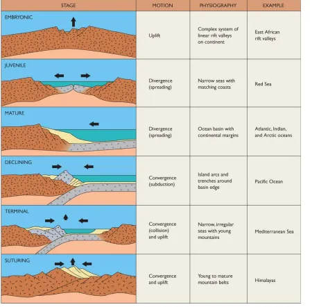
Wilson Cycle refers to the sequence of events leading to the formation, expansion,
contracting and eventual elimination of ocean basins.
• Stages in basin history are:
– Embryonic - rift valley forms as continent begins to split.
– Juvenile - sea floor basalts begin forming as continental
fragments diverge.
– Mature - broad ocean basin widens, trenches eventually
develop and subduction begins.
– Declining - subduction eliminates much of sea floor and
oceanic ridge.
– Terminal - last of the sea floor is eliminated and
continents collide forming a continental mountain chain.
The Wilson Cycle
3-3 Global Plate Tectonics
Mantle plumes originate deep within the asthenosphere as molten rock which rises and melts through the lithospheric plate forming a
large volcanic mass at a “hot spot.
Global Plate Tectonics
Figure 3-9 Volcanic Chains and Mantle Plume
Kilauea, Hawaii
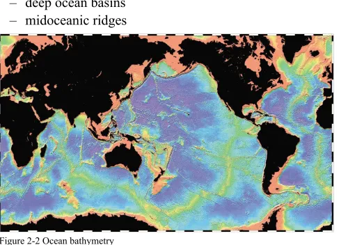
• Physiography and bathymetry (submarine landscape) allow the sea floor to be subdivided into three distinct provinces:
– continental margins – deep ocean basins – midoceanic ridges
The Physiography of the Ocean Floor
The Physiography of the Ocean Floor
• Continents are thick (30 to 40 km), have low density and rise high above the supporting mantle rocks.
• Sea floor is thin (4 to 10 km), has greater density and does not rise as high above the mantle.
The Physiography of the Ocean Floor
• Deep Ocean Province is between the continental margins and the midoceanic ridge .
• It includes a variety of features from mountainous to flat plains:
– Abyssal plains – Abyssal hills – Seamounts
– Deep sea trenches
The Physiography of the Ocean Floor
• Midoceanic Ridge Province consists of a continuous submarine mountain range.
• It covers about one third of the ocean floor.
The Physiography of the Ocean Floor
• Altimetry uses satellites to determine bathymetry.
• Based upon slight changes in the elevation of the sea surface.
• These changes result from the greater
gravitational attraction of large rock masses on the sea floor, such as volcanoes.
Altimetry
Figure B2-5 Altimetry
• Both pressure and temperature increase toward the center of the Earth, but at variable rates.
• Divisions of the Earth based upon physical states are: