Experiments with geographic knowledge for information extraction
Dimitar Manov,
Atanas Kiryakov,
Borislav Popov
Ontotext Lab, Sirma AI Ltd
38A Christo Botev Blvd, Sofia 1000,
Bulgaria
{mitac,naso,borislav}@sirma.bg
Kalina Bontcheva,
Diana Maynard,
Hamish Cunningham
University of Sheffield
Regent Court, 211 Portobello St.,
Sheffield S1 4DP, UK
{kalina,diana,hamish}@dcs.shef.ac.uk
Abstract
Here we present work on using spatial knowl-edge in conjunction with information extrac-tion (IE). Considerable volume of locaextrac-tion data was imported in a knowledge base (KB) with entities of general importance used for seman-tic annotation, indexing, and retrieval of text. The Semantic Web knowledge representation standards are used, namely RDF(S). An exten-sive upper-level ontology with more than two hundred classes is designed. With respect to the locations, the goal was to include the most im-portant categories considering public and tasks not specially related to geography or related ar-eas. The locations data is derived from num-ber of publicly available resources and com-bined to assure best performance for domain-independent named-entity recognition in text. An evaluation and comparison to high perfor-mance IE application is given.
1
Introduction
Information Extraction (IE) research has focused mainly on the recognition of course-grained entities like Loca-tion, OrganizaLoca-tion, Person, etc. (Sundheim, 1998). The application of Information Extraction to new areas like the Semantic Web and knowledge management has posed new challenges, from which the most relevant here is the need for finer-grained recognition of entities, such as lo-cations.
In this paper we present some experiments with build-ing a reusable knowledge base of locations which is used as a component into an IE system, instead of a location gazetteer. This work is part of the Knowledge and Infor-mation Management (KIM) platform and still undergoing development and refinement.
With respect to coverage, the goal was to include the most important location categories for a wide range of ap-plications and tasks, not specially related to geography or
related areas. The locations data is derived from a num-ber of publicly available resources and combined to as-sure best performance for named-entity recognition. An evaluation and comparison to high performance IE sys-tem using very small location gazetteers is given.
One important aspect of our work is that we choose to create a knowledge base of locations, structured accord-ing to an ontology and havaccord-ing relations between them, in-stead of having somewhat flat structures of gazetteer lists found in other IE systems. While a knowledge base can be plugged into an IE system instead of a flat gazetteer, it also has several unique advantages:
• the extra information, especially the transitive
sub-RegionOf relation can be used for disambiguation
and reasoning
• the location entities in the text can be recognised at the right level of granularity for the target applica-tion (i.e., as Locaapplica-tion or as Country, City, etc).
• the ontology and knowledge base can be modified by the user and any changes are reflected immedi-ately in the output of the IE system.
The paper is structured as follows. Section 2 puts our work in the context of previous research. Section 3 presents briefly the KIM platform, which contains the IE system and the location knowledge base. Then Section 4 describes the location knowledge base in more detail. The IE experiments are discussed in Section 5, followed by a discussion on problems and future work. The paper concludes by showing how such a knowledge base can be used to bootstrap a new IE system (Section 7).
2
Related work
the Perseus Digital Library project, is relevant because in future work we will improve the location disambiguation mechanism in our system.
2.1 Alexandria Digital Library Gazetteer
The Alexandria Digital Library (ADL), an NSF-funded project at the University of California, Santa Barbara, has included gazetteer development from its beginning in 1994. Currently it contains approximately 4.4 mil-lion entries. The data is taken from various sources, in-cluding NIMA (National Imagery and Mapping Agency’s of United States) Gazetteer, a set of countries and U.S. counties, set of U.S. topographic map quadrangle foot-prints, set of volcanoes, and set of earthquake epicenters. The Geographic Names Information System (GNIS) data from the U.S. Geological Survey has been partly added to the collection. The results as of today include the-saurus for feature types, Time Period data for the histori-cal entries and spatial data with boundaries. The bound-aries are defined as ”satisficing” rectangles. The term ”satisficing” is described in (Hill, 2000), and additional information about the project could also be found there as well as on the ADL gazetteer development page at http://alexandria.sdc.ucsb.edu/˜lhill/adlgaz/.
2.2 Toponym-disambiguation in Perseus Digital Library project
A disambiguation system for historical place names for Perseus digital library is described in (Smith and Crane, 2001). The library is concentrated on representing his-torical data in the humanities from ancient Greece to nineteenth-century America. The authors present a pro-cedure for disambiguation of such place names, based on internal and external evidence from the text. Internal ev-idence includes the use of honorifics, generic geographic labels, or linguistic environment. External evidence in-cludes gazetteers, biographical information, and general linguistic knowledge. Evaluation of the performance of the system is given, using standard precision/recall meth-ods for each of the five corpora: Greek, Roman, London, California, Upper Midwest. The system is best on Greek and worst on Upper Midwest corpus, and its overall per-formance for place names is higher than the most of other applications.
3
The KIM platform
The KIM Platform provides a novel Knowledge and In-formation Management (KIM1) infrastructure and ser-vices for automatic semantic annotation, indexing and re-trieval of unstructured and semi-structured content. The ontologies and knowledge bases are kept in Semantic
1
[image:2.612.317.537.69.252.2]KIM, see http://www.ontotext.com/kim
Figure 1: KIM Platform
repositories based on cutting edge Semantic Web technol-ogy and standards, including RDF(S) repositories2,
on-tology middleware3 (Kiryakov et al, 2002) and
reason-ing4. It provides a mature infrastructure for scalable and
customizable information extraction as well as annota-tion and document management, based on GATE (Cun-ningham et al., 2002). GATE, a General Architecture for Text Engineering, is developed by the Sheffield NLP group and has been used in many language processing projects; in particular for Information Extraction in a va-riety of languages (Maynard and Cunningham, 2003).
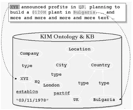
An essential idea for KIM is the semantic (or entity) annotation, depicted on figure 1. It can be seen as a clas-sical named-entity recognition and annotation process. However, in contrast to most of the existing IE system, KIM provides for each entity reference in the text (i) a pointer (URI) to the most specific class in the ontology and (ii) pointer to the specific instance in the knowledge base. The latest is (to the best of our knowledge) an unique KIM feature which allows further indexing and retrieval of documents with respect to entities.
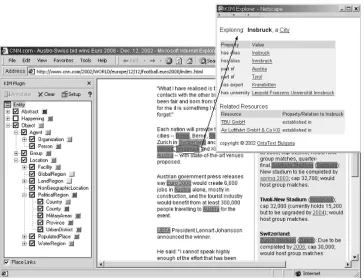
For the end-user, the usage of a KIM-based application is straightforward and simple - one can highlight text in the browser and further explore the available knowledge for the entity, as shown in figure 3. A semantic query web user interface allows for queries such as
”Organization-2
Sesame (http://sesame.aidministrator.nl/) is an open source RDF(S)-based repository and querying facility.
RDF, http://www.w3.org/RDF/. Resource Description Frame-work is an open standard for knowledge exchange over the Web, developed by W3C (www.w3.org).
3
OMM, http://www.ontotext.com/omm. Ontology Middle-ware Module is an enterprise back-end for formal knowledge management.
4
Figure 2: KIM architecture.
locatedIn-Country” to be executed.
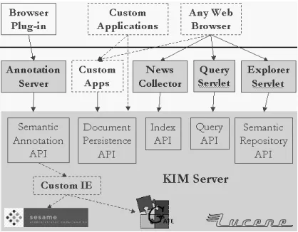
Information retrieval functionality is available, based on Lucene5, which is adapted to measure relevance to
en-tities instead of tokens and stems. The full architecture is shown in figure 2. It is important to note that KIM as a software platform is domain and task independent.
3.1 The ontology
KIM Ontology (KIMO) covers the most general 250 classes of entities and 40 relations. The main classes are
Entity, EntitySource and LexicalResource. The most
im-portant class in the ontology is Entity, further specialized into Object, Abstract and Happening. LexicalResource class and its subclasses are used for different IE-related information. The instances of the Alias class represent different names of instances of Entity. hasAlias relation is used to link Entity to its aliases (one-to-many rela-tion). The hasMainAlias links to the main alias (the of-ficial name). Each instance of Entity is linked to an in-stance of EntitySource via generatedBy relation. There are two types of EntitySource - Trusted and Recognized. The ”trusted” entities are those pre-defined. The recog-nized are the ones which were recogrecog-nized from text as part of the IE tasks.
The upper part of the ontology can be seen on the same figure 3 in the left frame.
For ontology representation we choose RDF(S), mainly because it allows easy extension to OWL6(Lite).
Location sub-ontology
Because the Geographic features (Locations) form a large part of the entities of general importance, we
de-5
Lucene, http://jakarta.apache.org/lucene/, high perfor-mance full text search engine
6
Ontology Web Language (OWL),
http://www.w3.org/TR/owl-semantics/
veloped a Location sub-ontology as part of the KIM on-tology. The goal was to include the most important and frequently used types of Locations (which are specializa-tions of Entity), including relaspecializa-tions between them (such as hasCapital, subRegionOf (more specific than part-of)), relations between Locations and other Entities (Organiza-tion locatedIn Loca(Organiza-tion) and various attributes.
The Location entity denotes an area in 3D space7, which includes geographic entities with physical bound-aries, such as geographical areas and landmasses, bodies of water, geological formations and also politically defined areas (e.g. ”U.S. Administered areas”).
The classification hierarchy (consisting of 97 classes) is based on the ADL Feature Type Thesaurus version 070203. The differences target simplicity; a number of distinctions and unnecessary levels of abstraction were removed where irrelevant to general (non-geographic) context, as we wanted the ontology to be easy to un-derstand for an average user. Examples of sub-classes omitted: Territorial waters, Tribal areas, Administrative Areas (its sub-types are put directly under Location).
The Location ontology provides the following addi-tional information:
• the exact type of a feature, for example to be able to recognize a geographic feature as CountryCapital instead of just Location.
• relations between geographic feature and other en-tities (e.g. ”Diego Garcia” is a MilitaryBase, lo-cated somewhere in the Indian Ocean and it is
sub-RegionOf USA).
• the different names of a location (”Peking” and ”Beijing” are two aliases for one location).
• the transitive subRegionOf relation allows one to search for Entities located in a continent (e.g. ”Mor-gan Stanley” - locatedIn - ”New York” - gionOf - ”NY” - subRegionOf - ”USA” - subRe-gionOf - ”North America”)
• ”trusted” vs ”recognized” sources in generatedBy property of a Location is an extra hint in disam-biguation tasks. The class hierarchy is shown in fig-ure 5.
7
Figure 3: KIM usage - highlight and explore. The upper part of KIM ontology (KIMO) is shown in the left frame.
3.2 The knowledge base
Geographic information usually introduces a high level of ambiguity between named entities, for the following three reasons:
• there could be several Locations with the same name (this includes sharing common alias);
• a name of a Location could match a common En-glish word (e.g. ”Has”, ”The”);
• other named entities (Company, Person, even Date or Numeric data) could share a common alias with a Location (examples: ”Paris Corporation”, ”O’Brian” county, ”10” district, ”Departamento de Nueve de Julio” with alias ”9 de Julio”).
In order to allow easy bootstrapping of applications based on KIM and to eliminate the need for them to write a Geo-gazetteer, the KIM knowledge base pro-vides exhaustive coverage of entities of general impor-tance. By limiting the Locations to only ”important” ones, we also keep the system as generic, domain- and task-independent as possible. The term ”importance” of a location is hard to define, and part of the problem is that it is dependent on the domain where the IE tasks are fo-cused. Yet it is common sense that such locations include continents, countries, big cities, some rivers, mountains, etc. In addition to the above predefined locations, KIM:
• learns from the texts it analyses;
• has a comprehensive set of rules and patterns help-ing it to recognize unknown entities;
• has a Hidden Markov Model learner, capable of cor-recting symbolic patterns.
As a test domain, KIM uses political and economic news articles from leading newswires8.
4
Populating the location knowledge base
As a main source of geographic knowledge we used NIMA’s GEOnet Names Server (GNS) data. GNS database is the official repository of foreign place-name decisions approved by the U.S. Board on Geographic Names (US BGN) and contains approximately 3.9 mil-lion features with 5.37 milmil-lion names. Approximately 20,000 of the database’s features are updated monthly. The data is available for download in standard formatted text files, which contain: unique feature index (UFI), sev-eral names per Location (the official name, short name, sometimes different transcriptions of the name), geo-graphic coordinates (one point; no bounding rectangle). Geographic coverage of the data is worldwide, exclud-ing United States and Antarctica. For U.S. geographic
8
Figure 4: RDF representation of a Location.
data we used partially USGS/GNIS data9, which
fol-lows similar format as GNS data. For country names we followed FIPS10, which was natural choice since GNS data is structured that way. A list of big cities was ob-tained from UN Statistics site, which covers city data (http://unstats.un.org/unsd/citydata/).
We then created a mapping between our location classes and GNS feature designators. Some of the features were completely ignored (e.g. ”abandoned populated places”, ”drainage ditch”), other were combined into one (e.g. ”ADM2”, ”ADMD” into County).
There is some inconsistency in the way the data is entered for different countries, mostly because of improper usage of designators (using different designators for similar ge-ographic features and vice versa). This made creation of the mapping a bit harder, as we needed to include more designators mapped to one class. The per-country files were almost consistently entered (with some exceptions, for example in UK, ”England”, ”Scotland”, ”Northern Ireland” and ”Wales” are entered as AREA, which hints the same importance as the other 40 areas in UK). We expect that a per-country mapping instead of a global one will lead to better performance results, yet we haven’t ex-perimented with this as it will require manual tuning for about 250 countries.
The different names of the geographic features are mapped to aliases of the Location entities, with a main alias pointing to the official name. The RDF represen-tation of a Location is shown in figure 4. Because these names sometimes match common English words and Per-son names a list of stop words is created and the aliases are filtered.
The import procedure uses the mapping described
9
US Geological Survey (UGCS); Geographic Names Infor-mation System (GNIS)
10
Federal Information Processing Standards, http://www.itl.nist.gov/fipspubs/
above but can also be restricted by list of countries and classes to be imported. Currently imported classes are:
Continent, GlobalRegion, Country, Province, County, CountryCapital, LocalCapital, City, Ocean, Sea, Gulf, OilField, Monument, Bridge, Plateau, Mountain, Moun-tainRange, Plain. These classes were selected as
”impor-tant”, based on common sense and statistical information derived from GNS data.
The GNS data has three main problems when it comes to extracting only geographical entities of global impor-tance and the relations between them:
• There is no way to tell the importance of a location (e.g. is Chirpan a big city or a small town);
• The only part-of relations available are between a location and its country, but not province or county;
• Some locations are not country-specific (e. g. oceans, seas, mountains) but are listed as separate locations with different identifiers in different per-country lists.
We addressed the first problem by limiting the types of lo-cations to a small subset of important ones (as explained above). The importance of cities was determined by us-ing a list of all big cities (with population over 100,000). We attempted to solve the second problem by using an al-gorithm to calculate the distance between a location and all provinces/counties in this country, and then to create a part-of relation with the nearest one. However, our ex-periments showed that the accuracy of the results was not satisfactory. This is mostly due to the fact that in GNS data only the location footprint is given, but not the ex-tent. Comparing the geographic coordinates of the loca-tions with a common alias and type and then combining the matching ones into a single entity in the knowledge base solved the third problem.
Currently the KB contains about 50,000 Locations grouped into 6 Continents, 27 GlobalRegions (such as ”Caribbean” or ”Eastern Europe”), 282 Countries, all country capitals and 4,700 Cities (including all the cities with population over 100,000). Each location has sev-eral aliases (usually including English, French and some-times the local transcription of the location), geographic coordinates, the designator (DSG) and Unique Feature Index (UFI), according to GNS. The figures for entities of global importance in KIM KB are shown in table 1.
5
Experiments with direct use for IE
Entities 77,561
Aliases 110,308
Locations 49,348
Cities 4,720
Companies 7,906
Public companies 5,150
Key people 5,500
[image:6.612.104.267.70.171.2]Organizations 8,365
Table 1: Instances per subclass of Entity.
being looked up in the text. Further, unknown or not precisely matching entities are recognized with pattern-based grammars:
• using location pre/post keys to identify locations, e.g. ”The River Thames”
• using location pre/post keys + Location, e.g. ”north Egypt”, ”south Wales”
• context-based recognition, such as: ”in” + Token-with-first-uppercase Number of disambiguation problems (mostly in the case of Location names oc-curring in the composite name of other Entities) are also detected and resolved:
• ambiguity between Person and Organization, e.g. ”U.S. Navy” (this would normally be recognized as a Person name from the pattern ”two initials + Fam-ily name”, but in this case the initials match a loca-tion alias)
• occurrence of locations in person names, e.g. ”Jack London” (disambiguated because in the KB there is
LexicalResource ”Jack” is a first name of Person)
• occurrence of locations in Organization names, e.g. ”Scotland Yard” (disambiguated because in the KB there is such Organization)
Finally, some of the recognized Entities (including Locations), which are not marked as noun by the part of speech tagger are discarded.
Some of the newly recognized Locations appear fre-quently in the analyzed texts. Those, which could be found in the GNS data are potential candidates to be en-tered in the knowledge base, because there is an extra evidence for their importance. This is a way to extend the knowledge base and make it contain all the ”important” Locations in the sense of frequently used in the one or more application domain(s).
The performance of the KIM system was measured on a news corpus using GATE’s evaluation tools. The sys-tem was also compared to an high-precision named entity recognition system, which uses small flat gazetteer lists.
Entity Number Location 792 Organisation 773 Person 764
Date 603
Percent 54
Money 94
Table 2: Distribution of entities in the corpus
5.1 Evaluation Corpus
The corpus was collected from 3 online English news-papers: the Independent, the Guardian and the Financial Times. In total it contains 101 documents with 56,221 words. The corpus was manually annotated with entities. Table 2 shows the number of entities of each type in the corpus.
5.2 Corpus Benchmark Tool
The Corpus Benchmark Tool(CBT) is one of the compo-nents in GATE which enables automatic evaluation of an application in terms of Precision, Recall and F-measure, against a set of ground truths. Furthermore, it also en-ables two versions of a system to be compared against each other (e.g. for regression testing) or two different systems to be compared. Each system is evaluated by comparing the annotations produced with a set of key an-notations (produced manually) and producing a score – two systems can therefore be compared with each other and indications are given as to where they differ from each other.
5.3 MUSE
MUSE is an information extraction system developed within GATE which aims to perform named entity recog-nition on different types of text (Maynard et al, 2002). MUSE recognises the standard MUC entity types of Per-son, Location, Organisation, Date, Time, Percent, and some additional types such as Addresses and Identifiers. The system is based on ANNIE, the default IE system within GATE, but has been extended to deal with a vari-ety of text sources and genres, and incorporates a mecha-nism for automatically selecting the most appropriate set of resources depending on the text type.
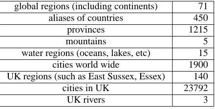
[image:6.612.373.482.70.157.2]global regions (including continents) 71 aliases of countries 450
provinces 1215
mountains 5
water regions (oceans, lakes, etc) 15 cities world wide 1900 UK regions (such as East Sussex, Essex) 140
cities in UK 23792
[image:7.612.75.295.71.183.2]UK rivers 3
Table 3: MUSE Location gazetteer entries
As can be seen from the location entries in the MUSE gazetteers, the system is specifically tailored to recognise UK locations with high recall and precision, whereas the KIM locations KB is not skewed towards any particular country.
We ran the MUSE system over our test corpus to see how KIM matched up to it.
5.4 Results
MUSE vs KIM performance comparison is given in ta-ble 4. When interpreting these results one also must bear in mind that the high-performance IE system is only tag-ging geographical entities as locations, whereas the GNS-based system is actually disambiguating them with re-spect to their specific type (e.g., City, Province, Country). Investigation of the reasons behind the lower recall shows that:
• the KB is too coarse-grained, i.e., there are no ”smaller” locations, such as small towns/counties in UK, we do not import military bases in KB from GNS data (”Diego Garcia”), etc.
• The application was not specifically tuned for the corpus/news texts, e.g. we do not use the fact, that the texts often clarify the locations when they are first mentioned (e.g., Aberdeen, UK).
• there are not any historical Locations, such as ”Soviet Union”.
It is expected that the first two problems will be fixed with enhancement of the KB with regard to domain targeting of a KIM-based application. To check this assumption we did another experiment. Because the corpus contains a lot of UK-related information (the articles are from three English newspapers) and MUSE is specifically tailored to UK locations, we needed extra UK-specific information in the KB. As we mentioned earlier the import procedure is flexible to the extend that allowed to add all the locations from UK GNS data. The performance of this enhanced KB is shown in table 5.
The recall is higher than in MUSE (increased to 95% vs 93%).
The precision is 10% behind MUSE (85% vs 95%). An obvious reason is that we have more entities in KB, and we do not control the aliases (except for stop words list), while all the locations in MUSE gazetteer lists are manually entered and therefore produce very little ambiguity.
6
Discussion
We produced a KB of locations with world wide cover-age using GNS data. The size of about 50,000 Location is more than most other IE systems have. It is not big (com-pared to 4M locations in ADL Gazetteer), but provides good coverage of Locations (91%). Because the KB was not tuned for the test corpus specifics we could expect similar coverage for other corpora.
Our flexible import procedure allows for domain-targeted versions of the KB (by means of importing more Location types) to be produced, which is expected to have good-enough coverage on locations.
The impact of the location KB on the IE performance is still under evaluation and improvement. We are work-ing on improvements in two directions: i) decreaswork-ing the amount of GNS-data entered in KB - for both locations and their aliases; ii) changing the way in which the IE system uses the KB to improve precision. On the latter, we are currently experimenting with applying the regular named entity recognition grammars first and then using the location KB to lookup only the unclassified entities, instead of using it as a gazetteer prior to named entity recognition as we do now.
7
Bootstrapping IE for new languages
from the KB
System Correct Partially Correct Missing Spurious Precision Recall F-Measure
MUSE 744 9 54 37 0.947 0.928 0.937
KIM 726 24 61 113 0.855 0.910 0.881
Table 4: MUSE vs KIM performance comparison
System Correct Partially Correct Missing Spurious Precision Recall F-Measure
MUSE 744 9 54 37 0.947 0.928 0.937
KIM-UK 759 28 27 167 0.810 0.950 0.874
Table 5: MUSE vs KB with all UK locations
Precision, 78% Recall and 76% F-measure. We predict that this kind of information will be very useful for the full Surprise Language Program in June, where partici-pants will have more time (a month) to create resources on another surprise language – not only for Information Extraction but also for tasks such as Cross-Language In-formation Retrieval and Machine Translation.
8
Conclusion and future work
This paper presented work on the creation of a locations knowledge base and its use for information extraction. In order to allow easy bootstrapping of IE to different languages and applications, we are building a knowledge base (KB) with entities of general importance, including geographic locations. The aim is to include the most im-portant and frequently used types of Locations. An evalu-ation and comparison to high performance IE applicevalu-ation was given.
The system is still under development and future im-provements are envisaged, mainly related to implement-ing better disambiguation techniques (e.g., like those de-scribed in (Smith and Crane, 2001)) and experimenting with new ways of using the KB from the IE application.
Acknowledgements
Work on GATE has been supported by the Engineering and Physical Sciences Research Council (EPSRC) un-der grants GR/K25267 and GR/M31699, and by several smaller grants. The last author is currently supported by the EPSRC-funded AKT project (http://www.aktors.org) grant GR/N15764/01.
References
Atanas Kiryakov, Kiril Simov, Damyan Ognyanov. 2002.
Ontology Middleware and Reasoning In the ”Towards
the Semantic Web: Ontology-Driven Knowledge Man-agement”, editors John Davies, Dieter Fensel, Frank van Harmelen. John Wiley & Sons, Europe, 2002.
Beth Sundheim, editor. Proceedings of the Seventh
Message Understanding Conference (MUC-7). ARPA,
Morgan Kaufmann, 1998.
David A. Smith and Gregory Crane 2001.
Disambiguat-ing Geographic Names in a Historical Digital Library.
In Proceedings of ECDL, pages 127-136, Darmstadt, 4-9 September 2001.
Diana Maynard, Valentin Tablan, Hamish Cunningham, Cristian Ursu, Horacio Saggion, Kalina Bontcheva, Yorick Wilks 2002. Architectural Elements of
Lan-guage Engineering Robustness. In Journal of
Natu-ral Language Engineering – Special Issue on Robust Methods in Analysis of Natural Language Data, 8 (1) pp 257-274
Diana Maynard and Hamish Cunningham. 2003.
Multi-lingual Adaptations of a Reusable Information Extrac-tion Tool. In Proceedings of EACL 2003, Budapest,
Hungary, 2003.
Hamish Cunningham, Diana Maynard, Kalina Bontcheva and Valentin Tablan. 2002. GATE: A Framework and
Graphical Development Environment for Robust NLP Tools and Applications. In Proceedings of the 40th
Anniversary Meeting of the Association for Compu-tational Linguistics, 2002.
Linda L. Hill. 2000. Core elements of digital gazetteers:
placenames, categories, and footprints. In J. Borbinha
& T. Baker (Eds.), Research and Advanced Tech-nology for Digital Libraries : Proceedings of the 4th European Conference, ECDL 2000 Lisbon, Por-tugal, September 18-20, 2000 (pp. 280-290). Berlin: Springer.
Nicola Guarino and Christopher Welty. 2000. Towards
a methodology for ontology-based model engineering.
Apendix A. Ontology screenshots
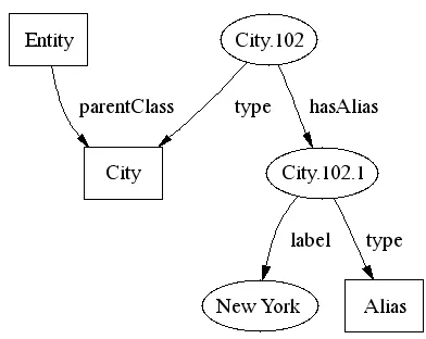
[image:9.612.316.454.274.492.2]Figure 5: Location sub-ontology.