Exploring the Capabilities of Projection Augmented Relief Models
(PARM)
Gary Priestnall
1, Alastair D. Smith
2, James Goulding
2, Nachnoer Arss
11School of Geography, The University of Nottingham 2School of Psychology, The University of Plymouth
2N-LAB, The University of Nottingham
Summary
This paper explores the broad capabilities of physical landscape models when augmented by projection, termed Projection Augmented Relief Models (PARM). This includes experiences of developing PARM displays in public settings such as museums and visitor centres and ongoing research to explore the apparent power of physical representations, both in experimental settings and
when applied to spatial decision support and education.
KEYWORDS: Physical relief model. Landscape Visualization. Public Display. Spatial knowledge acquisition. Geovisualization.
1. Introduction
Physical relief models have a long history of use, both for military planning and for offering visitors to new territories an overview of the landscape around them. They were often modelled in a photorealistic manner allowing subtle details in features, elevation and slope to be appreciated in addition to the broader spatial arrangement of places of interest. An example is Pfyffer’s 1786 model of central Switzerland which was large (26m2) but also relatively accurate as demonstrated through
photogrammetric techniques by Niederoest (2002). Some of the most effective styles of cartographic relief representation also originated in the alpine regions (Collier et al, 2003), though physical relief models maintained a presence in many public settings around the world despite the widespread availability of mapping in both paper and digital form.
The surface representation of relief models has typically been static but through projection there is the opportunity to explore the application of physical models to tell stories, to educate or to support spatial decision making, whilst benefitting from the engaging and effective spatial frame of reference offered by direct viewing of a physical three-dimensional model. The use of projection onto physical models (Dalsgaard and Halskov, 2011) has been termed the Projection Augmented (PA) model technique, a form of Spatial Augmented Reality (Bimber and Raskar, 2005). Projection onto landscape models has been used within the physical sciences, for example the ‘Illuminating Clay’ study (Piper et al, 2002) and subsequent developments (Mitsova et al, 2006), where manipulation of clay or sand models is detected and new contour maps or water flows are projected onto the model.
With milling and 3D printing there are opportunities to create detailed physical representations from digital geographic information and augment this with equally detailed maps, images or animations. This paper will explore Projection Augmented Relief Models (PARM), described in Priestnall et al
(2012) through public display, experimentation and their use in spatial decision support and informal learning.
2. PARM displays in public settings
Wordsworth Trust museum, Cumbria, UK was developed to highlight landscape references within William Wordsworth’s manuscripts. The focus was the connection between significant moments in childhood which influenced poetry written in later life and the characteristics of those locations.
Information was choreographed between a wall-mounted monitor, the projected imagery on the relief model, and an audio shower, organised into three sequences triggered from a touch screen panel (Figure 1, left). From a Human Computer Interaction (HCI) perspective the design had to attract people to interact and then potentially follow-up by visiting the actual physical manuscripts (Müller et al, 2010, Brignull and Rogers, 2003). Also of interest was the way physical relief models might prompt interactions, informed by studies based around flat tabletop displays (Genest and Gutwin, 2011).
[image:2.595.77.517.328.502.2]The design attempted to guide viewer gaze such that at certain times animated mapping and illumination effects on the relief model drew attention to parts of the Lake District landscape in the context of an overarching narrative. To help reveal how visitors interacted with the display video analysis was undertaken as part of a broader observation of the whole exhibition. Over 24 hours of video from a 4 day period was analysed and coded according to dwell time at the installation, completion rates for the three sequences, types of interactions observed, and notes of discussions relating to the display. In all, 141 visitors, or groups of visitors, were seen to engage with the display in some way. From the 57% of visitors, six broad categories of interaction emerged: three non-contact (move, point, hover), three contact, as shown in Figure 1 (right).
Figure 1. [Left] ‘Spots of Time’ installation. [Right] Categories and rates of interaction: (1) Move, 69% (2) Point, 25% (3) Hover, 11% (4) Touch, 69% (5) Stroke, 31% and (6) Trace, 4%.
Many viewers moved to change their perspective to gain new vantage points or discriminate subtle relief through motion. Touching, pointing and tracing were usually in relation to known places and often accompanied by group discussion about past or future routes whereas hovering and stroking appeared to confirm the physicality of the display to the viewer.
Figure 2. [Left] Nottingham Riots 1831 installation. [Centre] Southwell Workhouse National Trust installation. [Right] Lake District National Park Authority installation.
Another opportunity to explore public interaction with PARM came with an exhibition at Keswick Museum & Art Gallery in 2015 which attempted to convey the size and detail of Mayson’s Ordnance Model of the Lake District from 1875 (Figure 3, left), the negative moulds from which had been recently recovered. Moulds were scanned and digitally inverted and several replica tiles constructed and placed over a floor map to the scale of the whole model (Figure 3, centre). A PARM installation was used in this way acting as a ‘You Are Here’ map centred on Keswick (Figure 3, right). The affordance of completely free movement around the models to promote close inspection and wider views was clearly evident.
Figure 3. [Left] Reconstruction of Mayson’s Ordnance Model of the Lake District from 1875. [Centre] Reconstructed tile over floor map. [Right] PARM display over floor map.
Through developing the public PARM displays the protocols for designing the configurations and projection content have been refined. Also observations have confirmed the effectiveness of relief models in promoting interesting engagements with the landscape representations. Efforts to explore this in more detail have involved an experimental approach attempting to isolate some of the measurable benefits of using a physical spatial frame of reference.
3. Understanding the spatial frame of reference offered by physical models
[image:3.595.79.518.348.491.2]An experimental approach has involved direct comparisons between 2D maps and PARM, for both familiar and unfamiliar spaces. In one study, we projected a variety of different maps of part of the Lake District (e.g. satellite, contour, hill-shade) onto either a flat surface or a PARM surface of the same space. For both models, participants were asked to make a variety of comparative judgements, such as the relative height of two points, or the intervisibility between them. For all of these measures, PARM generated more accurate performance across participants particularly when satellite imagery formed the backdrop. PARM was particularly effective when assessing intervisibility where an understanding of egocentric reference frames was key, and judging water flow routes, where an understanding of the complexity of the surface was important. Participants did however take longer to respond using PARM which suggests that the addition of useful information may result in greater processing time when making relative judgements.
Figure 4. [Left] Comparing relative heights, intervisibility and paths of water flow, [Centre] Cones of vision to compare against a first person perspective view, [Right] Testing orientation to landmarks
4. PARM in spatial decision making and learning
The ability of PARM to provide a useful frame of reference to promote spatial knowledge acquisition is being explored through a number of applied case studies. One such example focusses on raising awareness of flood inundation patterns, focussing on Keswick in Cumbria, UK. This includes measuring people’s ability to recall areas that have been flooded, the impact on ‘landmarks’ and the various ways people refer to impact, and finally the patterns of inundation over space and time.
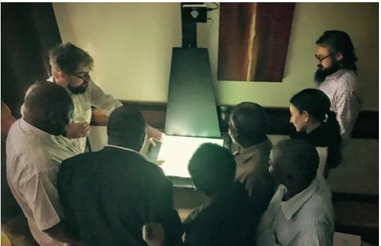
Figure 5. Use of a mobile PARM installation to aid Dar es Salaam city council and World Bank members in discussions of population mobility patterns in Tanzania.
5. Conclusions
Physical relief models offer engaging displays which let viewers explore landscape surfaces in some detail while also conveying the broader spatial context through a natural form of interaction. Evidence from public displays in museums and visitor centres supports this notion and the particular elements of the spatial frame of reference offered by such displays is being explored through a series of simple experiments. Informed by these experiences the technique is now being developed for use both as an aid to spatial decision support and for consultation and education, using flood mapping as a primary case study.
6. Acknowledgments
This abstract features work supported by the AHRC Creative Economy Knowledge Exchange Project “Archives, Assets and Audiences” and by a University of Nottingham Hermes outreach fellowship award. Thanks also to Sarah Beardsley and James Hazzledine at the Centre for 3D Design, School of Architecture and the Built Environment, the University of Nottingham; Ian Conway, School of Geography, the University of Nottingham. Figure 6 contains OS data © Crown copyright and database right (2016) © and Environment Agency copyright and/or database right 2015, All rights reserved.
7. Biography
Gary Priestnall is an Associate Professor within the School of Geography at the University of Nottingham. His research interests focus on digital geographic representation in a range of contexts, and utilising a range of technologies including virtual and augmented realities, Geographical Information Systems and location-aware mobile devices.
James Goulding is Assistant Professor and Deputy Director of N-LAB, a new centre for International Analytics at Nottingham University Business School, specializing in novel forms of data science - time series analysis, summarization and visualization of mass data sets. His work focuses on how closed source, commercial dataset can be harnessed to promote of international development and social good.
[image:5.595.159.437.71.250.2]Nachnoer Arss is a postgraduate research student within the School of Geography at the University of Nottingham. His research focusses on the effectiveness of physical relief models for spatial knowledge acquisition, using the Projection Augmented Relief Model (PARM) technique to explore the nature of the spatial frame of reference offered.
References
Bimber, O., and Raskar, R. (2005) Spatial Augmented Reality: A Modern Approach to Augmented Reality. Proceedings of Annual Conference on Computer Graphics and Interactive Techniques - SIGGRAPH’05. New York.
Brignull, H., Rogers, R. (2003) Enticing people to interact with large public displays in public spaces. INTERACT, 17-24.
Burgess, N. (2006). Spatial memory: how egocentric and allocentric combine. Trends in Cognitive Sciences, 10(12), 551-557.
Collier, P., Forrest, D., and Pearson, A. (2003) The Representation of Topographic Information on Maps: The Depiction of Relief The Cartographic Journal Vol. 40 No. 1, 17–26
Dalsgaard, P. and Halskov, K. 3D projection on physical objects: design insights from five real life cases. In Proc CHI. ACM Press, pp. 1041-1050, 2011.
Genest, A., Gutwin, C. Characterizing Deixis over Surfaces to Improve Remote Embodiments. ECSCW, pp. 253-272, 2011.
Mitsova H, Mitas L, Ratti C, Ishii H, Alonso J and Harmon R (2006) Real-time landscape model interaction using a tangible geospatial modelling environment, IEEE Computer Graphics and Applications, pp. 55-63
Müller, J., Alt, F., Michelis, D. and Schmidt. A. (2010) Requirements and design space for interactive public displays. In Proc. of Multimedia. ACM Press, pp. 1285-1294.
Niederoest, J. (2002) Landscape as a historical object: 3D Reconstruction and Evaluation of a Relief Model from the 18th Century The International Archives of the Photogrammetry, Remote Sensing and Spatial Information Sciences, Vol. XXXIV, Part 5/W3
Piper B, Ratti C and Ishii H: (2002) Illuminating Clay: a 3-D tangible interface for landscape analysis, Proceedings of the Conference on Human Factors in Computing Systems (CHI ’02), Minneapolis, MN, USA
![Figure 1. [Left] ‘Spots of Time’ installation. [Right] Categories and rates of interaction: (1) Move, 69% (2) Point, 25% (3) Hover, 11% (4) Touch, 69% (5) Stroke, 31% and (6) Trace, 4%](https://thumb-us.123doks.com/thumbv2/123dok_us/8565229.366847/2.595.77.517.328.502/figure-spots-installation-right-categories-interaction-point-stroke.webp)
![Figure 2. [Left] Nottingham Riots 1831 installation. [Centre] Southwell Workhouse National Trust installation](https://thumb-us.123doks.com/thumbv2/123dok_us/8565229.366847/3.595.79.518.348.491/figure-nottingham-installation-centre-southwell-workhouse-national-installation.webp)
![Figure 4. [Left] Comparing relative heights, intervisibility and paths of water flow, [Centre] Cones of vision to compare against a first person perspective view, [Right] Testing orientation to landmarks](https://thumb-us.123doks.com/thumbv2/123dok_us/8565229.366847/4.595.82.518.241.348/figure-comparing-relative-intervisibility-perspective-testing-orientation-landmarks.webp)