Northumbria Research Link
Citation: Kuliga, Saskia, Nelligan, Benjamin, Dalton, Ruth, Marchette, Steven, Shelton, Amy, Carlson, Laura and Hölscher, Christoph (2019) Exploring Individual Differences and Building Complexity in Wayfinding: The Case of the Seattle Central Library. Environment and Behavior, 51 (5). pp. 622-665. ISSN 0013-9165
Published by: SAGE
URL: https://doi.org/10.1177/0013916519836149 <https://doi.org/10.1177/0013916519836149> This version was downloaded from Northumbria Research Link: http://nrl.northumbria.ac.uk/39152/
Northumbria University has developed Northumbria Research Link (NRL) to enable users to access the University’s research output. Copyright © and moral rights for items on NRL are retained by the individual author(s) and/or other copyright owners. Single copies of full items can be reproduced, displayed or performed, and given to third parties in any format or medium for personal research or study, educational, or not-for-profit purposes without prior permission or charge, provided the authors, title and full bibliographic details are given, as well as a hyperlink and/or URL to the original metadata page. The content must not be changed in any way. Full items must not be sold commercially in any format or medium without formal permission of the copyright holder. The full policy is available online:
http://nrl.northumbria.ac.uk/pol i cies.html
This document may differ from the final, published version of the research and has been made available online in accordance with publisher policies. To read and/or cite from the published version of the research, please visit the publisher’s website (a subscription may be required.)
Abstract
This article focuses on the interactions between individual differences and building
characteristics that may occur during multi-level wayfinding. Using the Seattle Central
Library as our test case, we defined a series of within-floor and between-floor wayfinding
tasks based on different building analyses of this uniquely designed structure. Tracking our
59 participants while they completed assigned tasks on-site, we examined their wayfinding
performance across tasks and in relation to a variety of individual differences measures and
wayfinding strategies. Both individual differences and spatial configuration, as well as the
organization of the physical space, were related to the wayfinding challenges inherent to this
library. We also found wayfinding differences based on other, non-spatial features, such as
semantic expectations about destinations. Together, these results indicate that researchers and
building planners must consider the interactions among building, human, and task
characteristics in a more nuanced fashion.
Keywords: wayfinding, space syntax, spatial behavior, individual differences,
Exploring individual differences and building complexity in wayfinding: the case of the
Seattle Central Library
Large-scale, multi-level buildings, e.g., libraries, museums, shopping malls, and
hospitals, can be hard to navigate (Dogu & Erkip, 2000; Eaton, 1991; Li & Klippel, 2012;
Mandel, 2017), especially for first-time visitors (Baskaya, Wilson, & Özcan, 2004; Gärling,
Lindberg, & Mäntylä, 1983; Haq & Zimring, 2003; Hölscher, Meilinger, Vrachliotis,
Brösamle, & Knauff, 2006). One approach to a better understanding of the characteristics and
conditions linked to multi-level wayfinding is to identify particularly challenging or unusual
buildings and explore navigational behaviors within those settings.
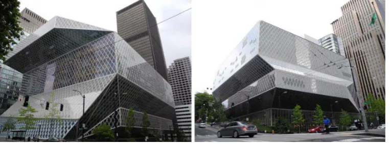
The Seattle Central Library (SCL; designed by Koolhaas, Prince-Ramus, OMA, and
LMN Architects, 2004; Image 1 and Figure 1), is a unique, award-winning structure
(American Library Association, 2005; Lacayo, 2004) that is viewed simultaneously as
architecturally important yet navigationally challenging (Mau, 2005; Murakami, 2006;
Pogrebin, 2004). Researchers from various disciplines have found that, from the perspective
of its users, this library’s spatial configuration, aesthetics, and functionality are complex
(Carlson, Hölscher, Shipley, & Dalton, 2010; Dovey, 2010; Fisher, Saxton, Edwards, & Mai,
2007; Mattern, 2007; Plank & Zisch, 2017; Seamon, 2017; Wang, 2017; Yaneva, 2009; Zook
& Bafna, 2012). One architectural critic even noted that this library is “one of the most
disorienting buildings one can imagine” (Dovey, 2017, p. 60).
In the present study, we examined navigational challenges in this multi-level building
within the context of a theoretical framework for wayfinding complexity (Carlson et al.,
2010; but also cf. Eaton, 1991; Golledge, 1999).
A framework for examining the complexity of multi-level wayfinding
Wayfinding is often framed as a process for active navigation through on-the-fly
immediately in direct view because the destination and/or the path to it is not fully visible
(Montello, 2005). Wayfinding includes self-localization within an environment, route
identification and planning, continuous monitoring while on the route, and recognition of the
destination upon arrival (Golledge, 1999). Accordingly, many factors, such as the building
configuration, and the spatial and orientation skills of building users, or a combination of
these, may determine whether wayfinding is successful.
Consequently, we based our work on a theoretical framework that posits that the
difficulty of a wayfinding task is an interaction between the individual’s and the building’s
characteristics (Carlson et al., 2010); including interactions among (1) the mental
representations of the space (i.e., cognitive maps) that individuals acquire and use during
wayfinding, (2) the building’s characteristics, and (3) the individual’s spatial skills and
wayfinding strategies (Figure 2). We did not evaluate the framework; we used it as a context
within which we could examine why some individuals find the SCL exhilarating while others
consider it distressing (Carlson et al., 2010; Fisher et al., 2007; Murakami, 2006).
Building characteristics and mental representations (cognitive maps)
In unfamiliar buildings, wayfinders must learn the spatial configuration to acquire a
mental representation of their surroundings (Allen, 1999; Arthur & Passini, 1992; Burgess,
Jeffery, & O’Keefe, 1999; Downs & Stea, 2011; Golledge, 1999; Kitchin, 1994; O’Keefe &
Nadel 1978; Tolman, 1948; Tversky, 1993). For multi-level wayfinding, this representation
must also include how different floors relate to each other. However, although individuals
can encode elevation information (Jeffery, Jovalekic, Verriotis, & Hayman, 2013; Lu & Ye,
2017), they may memorize multiple floors as a collection of separate floor layouts (layered
two-dimensionally), rather than one cohesive 3-D model (Büchner, 2010; Montello & Pick
1993; Nardi, Newcombe, & Shipley, 2011; Tlauka, Wilson, Adams, Souter, & Young, 2007;
wayfinders’ expectations during their decision-making process.
A building’s characteristics, such as its overall spatial configuration and local floor
layouts, signage, architectural or aesthetic differentiation, and visual accessibility (i.e., how
well a location is visually connected to the rest of the building) may facilitate or hinder the
formation of a coherent mental representation (Arthur & Passini, 1992; Evans, 1980; Li &
Klippel, 2012; Montello & Pick, 1993; O’Neill, 1991; Peponis, Zimring, & Choi, 1990;
Weisman, 1981). For example, a building’s layout complexity, signage, and visual
connections between locations are associated with the success of finding destinations (Li &
Klippel, 2012; O’Neill, 1991). At the same time, greater architectural variation allows the
wayfinder to distinguish locations more readily (Evans, 1980; Weisman, 1981). The SCL has
high spatial complexity, but substantial architectural and aesthetic variation, both within and
between floors. This may aid the establishment of a mental representation of locations.
In addition, visual accessibility to vertical travel options and other areas means that
more spatial information is available, such that the wayfinder needs less stored spatial
knowledge to act (Haq & Zimring, 2003; Li & Klippel, 2012). The SCL design has strong
visual connections between floors (i.e., an atrium, and glass walls that allow views to other
floors), but only partial visual links to its vertical travel options. For example, yellow
escalators that are visible from highly frequented areas reach specific sub-sets of floors while
bypassing other, more secluded floors. In contrast, the staircases that connect floors bypassed
by those escalators are located in more segregated, remote locations and are not obvious from
these highly frequented areas. Therefore, we would expect that wayfinding is more difficult
when visual accessibility to vertical travel options is limited. Furthermore, wayfinders tend to
prefer navigating through areas that are both more visually accessible and have more
connections to other parts of the building. Such areas can be termed ‘central’ in a building
& Zimring, 2003; Kuipers, Tecuci, & Stankiewicz, 2003; Peponis et al., 1990). Consequently,
we might predict that wayfinding performance is better when start and destination locations
are central in the building, and/or central within an individual floor.
The complexity of multi-level wayfinding can be further increased by the presence of
multiple floor layouts. Changes in the layout from one floor to the next, and a misalignment
of layouts in relation to adjacent floors, can pose a particular challenge when trying to
develop a representation of the building. In Carlson et al.’s framework (2010), this concept is
referred to as the ‘correspondence’ between a mental representation and building
characteristics. When layouts change across floors, wayfinders can experience vertical
disorientation and erroneous navigation (Carlson et al., 2010; Hölscher et al., 2006; Soeda,
Kushiyama, & Ohno, 1997). Within the SCL, Floors 6 through 9 share relatively similar
layouts but Floors 1 through 5, and 10, differ radically from each other. Moreover, many
floors are misaligned in both orientation and shape. As such, the SCL design might encourage
either highly disjointed or grossly incorrect mental representations that might have an impact
on between-floor wayfinding. Thus, we would expect less success and reduced performance
(e.g., longer routes, or more pauses) for between-floor tasks than for within-floor tasks.
Individual differences in spatial reasoning and wayfinding strategies
During the wayfinding process, the wayfinders’ mental representations may also be
affected by differences in their spatial-cognitive abilities. In Carlson et al.’s framework
(2010), the ‘completeness’ intersection defines how strategies and skills influence which
routes wayfinders take or prefer, as these aspects are associated with acquiring more or less
complete mental representations (Figure 2).
Although studies about individual differences in spatial abilities and wayfinding in
large-scale, real-world buildings have been limited (Hegarty, Montello, Richardson,
accepted that spatial skills contribute to differences in navigational behavior (Allen, 1999;
Hartley, Maguire, Spiers, & Burgess, 2003; Kozhevnikov & Hegarty, 2001; Montello & Pick,
1993; Vandenberg & Kuse, 1978; Wolbers & Hegarty, 2010). Here, we adopted a
comprehensive approach to assess those differences in spatial abilities. We took the following
steps to examine mental spatial transformations, self-perceptions, wayfinding strategies, and
spatial preferences:
Mental spatial transformations. Spatial perspective-taking (i.e., the ability to
imagine the world from different vantage points) and mental rotation (the capacity to imagine
objects or arrays rotating about one or more axes) are distinct skills that vary widely across
individuals (Kozhevnikov & Hegarty, 2001; Shelton & Zacks, 2015; Zacks & Michelon,
2005). Both types of skills are connected with environmental learning (Hegarty et al., 2006;
Kozhevnikov, Motes, Rasch, & Blajenkova, 2006). For example, spatial perspective-taking is
associated with various aspects of learning and navigating within an environment (Allen et
al., 1996; Hegarty & Waller, 2004; Kozhevnikov & Hegarty, 2001), whereas mental rotation
is linked to the spatial processing of complex environmental structures (Fields & Shelton,
2006; Hegarty & Waller, 2004; Shelton & Gabrieli, 2004).
For wayfinding in the SCL, we anticipated finding strong relationships among our
wayfinding tasks and these mental spatial transformation skills. This was because the
substantial visual variation and lack of structural alignment, especially when reasoning across
floors, would increase the demands on participants to form, reason about, and manipulate
mental representations of the space.
Self-perceptions: sense of direction and spatial anxiety. In addition to measurable
abilities, people vary in their self-perceptions about space. We considered two aspects: how
‘good’ and how confident am I with spatial challenges, and how comfortable am I with these?
space (Hegarty, Richardson, Montello, Lovelace, & Subbiah, 2002). It is positively related to
various measures of environmental knowledge, e.g., direction-pointing, map-drawing, and
estimates of distance (Allen, 1999; Hegarty et al., 2002), as well as to tasks that require
survey knowledge (Hegarty et al., 2002; Kozlowski & Bryant, 1977). Spatial anxiety is the
stress one might experience when required to reason about space (Lawton, 1994). Higher
levels of anxiety are correlated with more navigational errors (Hund & Minarik, 2006).
Given the wide range of reactions to the SCL in terms of its wayfinding challenges
(e.g., Dalton, Kuliga, & Hölscher, 2013), we anticipated that the building would tax the sense
of direction and be particularly unnerving to those with high spatial anxiety. As such, we
predicted that these self-perception measures would be correlated with wayfinding
performance, especially in our most challenging tasks.
Wayfinding strategies & spatial preferences. Several types of wayfinding strategies
in multi-level buildings have been identified (Allen, 1999; Golledge, 1999). For example,
some wayfinders might first head toward the approximate area of a destination and then
engage in a more detailed local search (Wiener, Schnee, & Mallot, 2004), whereas others
might use salient points in an environment for reference (Hölscher et al., 2006; Tellevik,
1992). It is also likely that wayfinders follow intrinsic heuristics, such as using long sightlines
(Frankenstein, 2015; Hochmair & Karlsson, 2005).
The ability and/or tendency to employ different wayfinding strategies depends upon
individual differences in the types of spatial information that people seem to prefer when
navigating (Lawton, 1994; Meneghetti, Pazzaglia, & De Beni, 2011; Pazzaglia & De Beni,
2001). Here, we measured spatial preferences for these three types: 1) egocentrically oriented
route knowledge, based on previously experienced routes; 2) landmark knowledge, based on
the spatial relations among salient objects (Pazzaglia & De Beni, 2001); and 3) survey
distances, and relationships among objects (Meneghetti, Pazzaglia, & De Beni, 2011). These
spatial preferences would likely interact with the building characteristics and the information
that they afforded, thereby influencing which properties would be represented on a cognitive
map. In Carlson et al.’s framework (2010), this corresponded to the ‘compatibility’ between a
wayfinder’s ability and preferences, and the building’s characteristics (Figure 2).
Taking into account how spatial preferences for wayfinding strategies, and strategy
selection, might be linked to building properties, we hypothesized that preferences for survey
information (rather than route or landmark information) at the SCL were related to
understanding its difficult overall configuration, as manifested in better wayfinding
performance. Moreover, we proposed that the particular advantage/disadvantage of any
preference would vary with the specific type of wayfinding tasks based on building
characteristics for the areas through which a participant would be navigating.
Research aims and hypotheses
Based on our elaboration of the framework for wayfinding complexity (Carlson et al.,
2010), we argued that aspects of this library and individual differences among wayfinders
would predict performance. In particular, we designed this study to examine more closely the
relationships among certain building characteristics (e.g., accessibility and floor navigation)
and an individual’s orientation skills and wayfinding strategies. We selected the SCL due to
its architectural characteristics and began with a spatial analysis to develop appropriate
wayfinding challenges that would address our manipulation of floor navigation (within- vs.
between-floor) with a manipulation for accessibility (high vs. low). The tasks were designed
to carry different wayfinding challenges, and to test the following hypotheses:
H1: Wayfinding performance between and within floors will be related to spatial
analyses of accessibility in the following ways:
b. Performance will be better if visual accessibility is higher.
c. Performance will be better when starts/destinations are located in central areas.
H2: Wayfinding performance between and within floors will be related to individual
differences in spatial reasoning and wayfinding strategies in the following ways:
a. Performance will be better when spatial abilities (mental spatial transformations)
and/or sense of direction are stronger.
b. Performance will be better when spatial anxiety is lower.
c. Performance will be better for wayfinders who show a preference for survey
information (rather than route or landmark information).
d. Performance will be different in each specific type of wayfinding task, as the effects
of skills, strategies, and self-perceptions mentioned in H2a-c will interact.
Method
Research design
Based on this framework, we established a 2 × 2 design, with the factors of floor (within/between) and accessibility (high/low), to test H1 and H2.
The within-floor versus between-floor factor was based on research that multi-level
wayfinding is typically more difficult than wayfinding within a single floor (Hölscher et al.,
2006; Li & Klippel, 2012; Soeda, Kushiyama, & Ohno, 1997). Research indicated that certain
building characteristics (such as complex configurations, substantial visual variation, lack of
structural alignment, and blocked visual access) might hinder the formation of a coherent
mental representation of the building, thus making it harder to find certain destinations (Haq
& Zimring, 2003; Li & Klippel, 2012; Weisman, 1981). We selected visual and spatial
accessibility as the basis of our task classification to capture these factors. Thus, each task
classification was drawn from building analyses of SCL characteristics.
Building analyses to develop a wayfinding task classification
To define origin–destination pairs that fit the floor × accessibility manipulations, we first conducted a building walk-through, photograph-based evaluations, and qualitative
interviews with key library stakeholders (anonymity requested). During the walk-through, we
identified the visual accessibility of route options, signage, and vertical travel options,
including stairs, ramps, and escalators; as well as changes in horizontal/vertical directions
along a route and the saliency of wayfinding cues (e.g., the yellow escalators). These aspects
are posited to be good proxies for wayfinding challenges (cf., Chang, 1998; Montello, 2014).
Second, we used a number of space syntax techniques that quantify an environment’s
spatial characteristics (Hillier & Hanson, 1984). Space syntax is highly predictive of
movement flows, wayfinding decisions, and wayfinders’ understanding of spatial
environments (Dara-Abrams, 2006; Haq & Zimring, 2003; Li & Klippel, 2012; Montello,
2014; Penn, 2003; Peponis et al., 1990). This process i) divides a building into subspaces; ii)
links all of these subspaces into a network and iii) derives quantitative measures that are
either based on a small part of the whole network (local measures) or use the entire network
(global measures) (Bafna, 2003; Hillier & Hanson, 1984). An analysis of both global and
local spatial characteristics is then predictive of wayfinding performance (Li & Klippel,
2016). We implemented the following specific measures for spatial analysis:
Floor manipulation.
Overall building configuration: intelligibility. ‘Intelligibility’ is a space syntax
measure for evaluating a building’s legibility (the relationships between local spatial
characteristics and global network measures). This measure expresses the ease and
predictability of an environment in terms of wayfinding (Bafna, 2003; Dara-Abrams, 2006;
environment (cf., Zhang, Chiaradia, & Zhuang, 2013), intelligibility of the SCL is lower than
that described for other facilities in previous wayfinding studies (cf., Haq & Zimring, 2003;
Hölscher, Brösamle, & Vrachliotis 2012; Mavridou, 2012). This demonstrated the
disorienting spatial complexity of our study site, making the SCL an excellent test case.
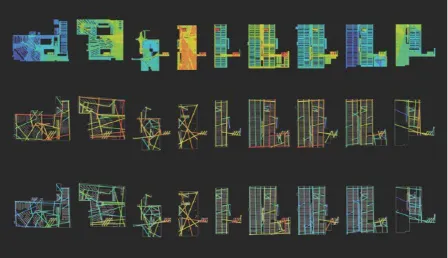
Within- and between-floor configuration: axial line analysis. In axial line analysis
(Figure 3), the network’s subspaces consist of lines of sight and movement that, when
combined into a network, represent the navigable structure of a building (Bafna, 2003; Haq &
Zimring, 2003; Hillier & Hanson, 1984). It reveals how wayfinding is related to a building’s
spatial layout, with unexplained variance often being associated with individual differences
(Penn, 2003).
For examining global accessibility (i.e., the number of spatial connections to a
location from the rest of the building), we applied a measure called integration, which
describes how accessible one location is from all other locations in a building (Bafna, 2003).
To gauge local accessibility (i.e., the number of spatial connections to a location from an
adjacent and subset of the larger network) of within-floor spaces, we used ‘axial line
integration radius three’, a proximal measure that excludes all spaces beyond three
changes-of-direction (Bafna, 2003). The local integration measure enabled us to develop an initial set
of starts/destinations in accessible and central, and in segregated and remote parts of the
building within a floor. These were further refined as follows:
Accessibility manipulation.
Visibility graph and isovist analysis. In visibility graph analysis (VGA, Figure
3), the network’s subspaces consist of mutually visible location-pairs (Turner, Doxa,
O’Sullivan, & Penn, 2001; Turner & Penn, 1999). This allowed us to calculate measures that
identify mutually visible locations across all floors. Using VGA, we again used the measure
integrated while Floor 4 was the least.
The concept of integration can also facilitate further predictions of task difficulty for a
set of origin–destination pairs. Such an approach has been described by Hölscher et al.
(2012). Integrated spaces tend to be anchors for wayfinding (Haq & Zimring, 2003; Peponis
et al., 1990) because a greater number of routes are more likely to pass through such
integrated locations (Batty, 2004, 2004b, 2017). Thus, for a series of tasks, wayfinders will
most likely have already been exposed to these more integrated locations as their tasks
progress. Using this rationale, we developed a system of task classification. This approach
involved assuming that (1) wayfinding from and to an integrated and visually accessible
location would be easy because of high (‘h’) accessibility, and (2) navigating between any
two segregated locations would be hard due to low (‘l’) accessibility. Along with our
within-floor (‘w’) and between-within-floor (‘b’) manipulations, this analysis provided a classification for
our wayfinding tasks: (‘w/h’), (‘w/l’), (‘b/h’), and (‘b/l’).
Refinements. In addition, for each set of potential origin–destination pairs, we
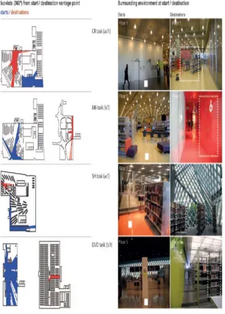
applied an isovist analysis (Benedikt, 1979; Benedikt & Burnham, 1985) to examine local
visual accessibility at the starts and destinations (Figure 4). This was done only to ensure that
destinations were never directly visible from the start locations (Montello, 2005).
We examined whether destinations were distinctive, memorable (Montello, 2017;
Nothegger, Winter, & Raubal, 2004; Presson & Montello, 1988; Steck & Mallot, 2000), and
unambiguous (Grice, 1975; Hölscher, Tenbrink, & Wiener, 2011). We ensured that they were
unique locations and salient (our judgement) and that they were congruent with the building’s
signage (i.e., the names in the library’s signage were replicated in our instructions).
We conducted a walk-through to confirm that the tasks met the floor (within/between)
and accessibility (high/low) manipulations from a wayfinder’s eye-level perspective.
Incorporating the above space syntax analysis, we developed four core trials and two
additional wayfinding tasks that addressed our manipulation of the floor navigation
(within/between) with the manipulation of accessibility (high/low):
The four core tasks covered Floors 1 through to 7 (Table 1): the Children’s
Restrooms, ‘CR’ (w/h); Meeting Room Number Six, ‘M6’ (b/l); a book about Sherlock
Holmes, ‘SH’ (w/l); and the section featuring Non-fiction DVDs, ‘DVD’ (b/h). These
wayfinding trials, conducted with all participants, were the focus of the current analysis.
For the second data collection, we provided extra time to include two extra tasks
covering Floors 7 to 10: the Aviation Room special collection, ‘AR’ (w/l); and the Music
Practice Rooms, ‘MPR’ (b/h). Only the local group had this additional exposure to these two
tasks. We always assigned those additional tasks to be finished after the four core trials were
completed, to prevent contamination of the wayfinding solutions for the critical trials.
To fully disclose our protocol, the above section has mentioned all six wayfinding
tasks. For statistical power and reading clarity, this article focuses only on the outcomes from
the four core trials.
Types of tasks: challenges and demands in each wayfinding task
We designed each task to have specific demands and challenges, as follows:
The CR within-floor/high accessibility(abbreviated as: w/h) task entailed
wayfinding from and to an accessible/central location. Relying on the established task
classification, we expected this task to be easy.
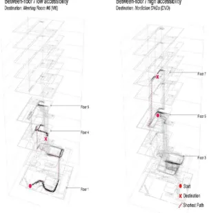
The M6 between-floor/low accessibility (b/l) task called for wayfinding from a
segregated, remote start to a segregated destination with low visual accessibility at the start.
After changing floors, the destination on Floor 4 and the sign indicating room number ‘6’
were already visible from the atrium on Floor 3. However, the shortest route, via a staircase,
participants would bypass the destination floor and subsequently have to find a way to
descend from Floor 5. Relying on our classification, we expected this task to be hard.
As part of the SH within-floor/low accessibility (w/l) task, both the starting point (in
the Teens’ section of the library), and the destination (in the Mystery Fiction section) were
located in segregated areas on Floor 3. Except for bookshelf information, no other relevant
signage was nearby. As such, relying on our classification, we expected this task to be hard.
For the DVD between-floor/high accessibility (b/h) task, participants started in a
highly accessible area on Floor 5 where visual information was abundant in the form of
signage, a directory, and vertical travel options in direct sight. The destination was nearby,
located exactly one floor above a wayfinder’s start position. We expected this task to be easy.
Regardless of whether the task was to find specific media, a book, or a special
collection, these types of tasks were associated with unique locations. Thus, reaching the
intended position in front of a door or shelf would be considered successful wayfinding
because those locations could be inferred and found only if the participant understood how
the library building was spatially organized (cf., Montello, 2005).
The size of the target and its visual salience at the destinations were addressed as part
of the floor manipulation: the CR and M6 destinations had entrance doors of similar size, and
the SH and DVD destinations were bookshelves of similar height with similar visual salience,
and both located within special sections. All destinations were functionally grouped within a
larger semantic category or section (half a floor for only the children; half a floor for only the
meeting rooms; special sections for Fiction and Non-fiction DVDs, or for mystery books).
Participants and recruitment
Participants were recruited on two separate occasions. The conference group
comprised 31 persons who were invited for a one-day experiment as part of an academic
the field of cognitive or experimental psychology. To balance this potentially selective group
with one that might better represent the general population, we assembled a second, local,
sample of 36 volunteers recruited by advertising on a forum for events in the Seattle
community (Craisglist, n.d.). For both groups, we focused on first-time visitors because we
wanted individuals who would need to learn the structure of the building. We considered
participants who self-reported that they had never visited the building before. To ensure the
accuracy of these self-reports, during our post-study questionnaires, we asked again whether
the given participant was previously familiar with the library. After the debriefing procedure,
we informally inquired, once more, about familiarity with the building.
Using this threefold procedure, we identified and then excluded data of three potential
participants who indeed appeared familiar with the building. Another five persons were
dismissed due to technical issues. Thus, the reduced sample involved 31 volunteers in the
local group (16 female; Mage=30.32; SD=12.10; 18-61 years old) plus 28 from the conference
group (15 female, Mage=34.81; SD=12.44; 21-68 years old). This screening procedure
resulted in a final sample size of 59 participants (31 female, Mage=32.41; SD=12.36; 18-68
years old).
Dependent variables
Wayfinding performance. We argued that shorter wayfinding times and distances,
smaller deviations, less sign usage, and fewer pauses reflected a better wayfinding
performance, which was measured in terms of the dependent variables wayfinding time (in
min”sec’), distance (d, in meters), deviation (in percentage), sign usage (as frequency), and
pauses (as frequency). We assumed that the performance was an indirect measure of the
quality of one’s cognitive map and the wayfinding strategies individuals relied upon – and
that it would be associated with specific characteristics of the SCL (Carlson et al., 2010).
i.e., deviation/PAO = (𝑑𝑑𝑐𝑐𝑐𝑐𝑐𝑐𝑐𝑐𝑐𝑐𝑐𝑐𝑑𝑑−𝑑𝑑𝑠𝑠ℎ𝑐𝑐𝑐𝑐𝑜𝑜𝑐𝑐𝑠𝑠𝑜𝑜
𝑑𝑑𝑠𝑠ℎ𝑐𝑐𝑐𝑐𝑜𝑜𝑐𝑐𝑠𝑠𝑜𝑜 ∗100). Deviation/PAO expresses superfluous distances (Büchner, 2010; Peponis et al., 1990; Ruddle, Payne, & Jones, 1997; Wiener et al.,
2004). A value of zero meant that the wayfinder had stayed on the shortest path while a score
of 200 represented twice the distance when the shortest path was subtracted.
We recorded sign usage during a task because we assumed that this component
reflected a particular wayfinding strategy that confirmed the participant was still navigating
the selected path. This was noted as a person glancing at a sign while moving past it (sign
usage), as well as stopping to read a sign (pause + sign usage). Because we knew the
locations of the signs, we separated pause and sign-usage frequencies post-hoc. Here, pauses
were thought to reflect hesitations, uncertainty, and a participant’s need for information.
The above behavioral mapping was conducted by four observers for the conference
sample and one observer for the local sample, all of whom were closely trained with a
protocol. The accompanying observers recorded a participant’s wayfinding performance with
a developer’s version of the iPadapp “PeopleWatcher”(Dalton, Dalton, & Hölscher, 2015).
We cleaned the resulting data sets from the app, and summarized the data obtained for
wayfinding time, distance, deviation/PAO, sign usage, and pauses during each task, using a
custom-made script for Matlab (n.d.)before conducting statistical analysis in SPSS 23 (n.d.).
Individual differences in spatial reasoning and strategies. We categorized the
participants with respect to their skills in reasoning about spatial relations, sense of direction,
wayfinding preferences, and spatial anxiety. This was accomplished through standardized
questionnaires: the Mental Rotation Test (Vandenberg & Kuse, 1978), Spatial
Perspective-taking Scale (Kozhevnikov & Hegarty, 2001), Santa Barbara Sense of Direction Scale
(Hegarty et al., 2002), Questionnaire on Spatial Representation (Pazzaglia, Cornoldi, & De
Beni, 2000), and Spatial Anxiety Scale (Lawton, 1994). These instruments were administered
participants to rank their wayfinding tasks from easiest to hardest (resulting in the dependent
variable ‘ranked task difficulty’), and to describe, briefly, their wayfinding strategies in each
task. Replaying the performance trajectories allowed us to consider variations in paths of the
same length, to determine whether they might represent different approaches and error types.
Wayfinding task instructions
The sequence of the wayfinding tasks was fixed, with the destination of one task
being linked to the start of the next. This sequence was circular, so that we could randomly
select the first task for each participant. This produced four different orders for the four core
trials (i.e., CR-M6-SH-DVD, M6-SH-DVD-CR, SH-DVD-CR-M6, and DVD-CR-M6-SH).
For the local group, the final two trials were counterbalanced following each of these order
(e.g., CR-M6-SH-DVD—AR-MPR, CR-M6-SH-DVD—MPR-AR, etc.). For each of the
tasks, multiple routes with different distances to the destination, were available.
In keeping with our need for communicable locations, the instructions included a hint
about whether the task was within or between floors. Instructing the participants to identify
the shortest way, we cautioned them that they were not allowed to use the elevators or ask
others for directions. This policy was enforced by the observer accompanying the participants
to record behavior. We informed participants that the maximum time for each task
completion was 10 minutes.
Procedure
For the conference group, participants were greeted offsite and escorted to the SCL by
a study team member. Initially arriving in groups of four, each person was tested
individually. During the trial period, participants were kept separate by following a different
order for the tasks. For the local group, the observer welcomed each participant individually
in a quiet nearby café. After providing consent for the study via a standardized form, each
the respective task instructions and made sure that the participant understood the instruction
to find the shortest way. Participants repeated which destination they were asked to find.
The wayfinding procedure was the same for the two groups. If a participant stated
incorrectly that a destination had been reached, the observer asked her or him to continue the
search. We did not use the words ‘error’ or ‘incorrect’ because this could have negatively
affected a person’s self-perceptions during later tasks. If the participant verbally confirmed a
correct destination, or if the time limit was reached, the observer stopped the recording. The
observer then guided the participant to the next start location, using a pre-defined path and
the elevators, in order to limit the amount of additional path information that the participant
might incidentally acquire. The participant then received the instructions for the next task.
After completing her or his four tasks (conference group) or six tasks (local group),
the participant completed a printed set of questionnaires in a room at either the conference
venue (conference group) or the café (local group). The conference venue and the café had
few or no other visitors, and background noise was very low.
We randomized the order of the questionnaires for each participant. Only the Spatial
Perspective-taking Scale and the Mental Rotation Test were timed according to the advised
procedures. The researcher informed participants that there would be no feedback about the
results. All participants were fully debriefed about the study purpose; those from the local
group received $30 each. The entire study procedure took two hours.
Results
Testing for differences between the two sample groups
We first tested whether we could justify merging the conference sample and the local
sample to increase the statistical power for our analyses. A multivariate ANOVA for
individual differences in spatial skills, self-perceptions, and spatial preferences indicated that
sense of direction, spatial anxiety, and spatial preferences (Table 2). Results from a
multivariate ANOVAfor each of the six dependent performance variables demonstrated that
the samples differed little (i.e., only the wayfinding time and pauses variables differed
between groups, for two tasks: locals were less efficient in the SH w/l task; Table 3). Thus,
we merged the samples, and examined only the ‘stable’ dependent variables of distance,
deviation/PAO, sign usage, and ranked task difficulty. To increase power, we analyzed and
present here only the data gained from the four core trials conducted with both groups.
Wayfinding performance in relation to the spatial analyses
Examining the floor and accessibility manipulation. The first hypothesis was that
wayfinding performance between and within floors would be related to the spatial analyses of
accessibility (H1). Our tasks were specifically designed to test the floor × accessibility-related expectations that navigating within floors (H1a), greater visual accessibility (H1b),
and central destinations (H1c) would facilitate performance. According to this rationale,
because those tasks were designed to have the above challenges, CR should have been the
easiest task, followed by SH and DVD, with M6 being the hardest.
To test these assumptions, we ran separaterepeated-measures ANOVAs with the
manipulated within-subject factors floor (within/between) and accessibility (high/low) for
each of the stable dependent variables that expressed performance (i.e., ranked task difficulty,
distances, deviation/PAO, sign usage) for the four core trials. As shown in Table 4, the actual
performance results differed from our preliminary expectations, as follows:
In the ratings of perceived difficulty, participants ranked the CR (w/h) task as the
easiest, as predicted. However, the DVD (b/h) task was ranked as more difficult than all other
tasks. Moreover, the within-floor SH (w/l) task was ranked as more difficult than the M6 (b/l)
task. Therefore, the difficulty (from easy to hard) that we had predicted (CR < SH < DVD <
The same inconsistency with our predictions was evident in performance measures.
Results for distances, as well as for sign usage indicated that the DVD task (b/h) was harder
than predicted. That is, participants traversed longer distances in that task than for the M6
task (b/l), even though they used signage to the same extent for both of these between-floor
tasks. The lowest deviation/PAO was found for the M6 task (b/l), rather than for CR (w/h),
while the highest deviation/PAO came from a within-floor task (SH).
In summary, we did not find support for H1/H1a-c. These reversals in the floor and
accessibility manipulations suggested that our building analysis did not fully capture the
wayfinding complexity of the floor × accessibility manipulation as we had predicted. However, up to this point, it was possible that performance was mainly related to individual
differences in spatial reasoning and wayfinding strategies, so that consistencies across tasks
might indicate good versus less-efficient wayfinders. Thus, our next analysis was intended to
evaluate the consistency of performance across tasks.
Consistency of wayfinding performance across tasks. To assess the consistency of
wayfinding performance across tasks, we conducted Pearson’s correlations.
First, we examined the relationships between pairs of different dependent variables
that measured performance, separately for each task. Given that they were supposed to
indicate performance, they were expected to be interrelated. Table 5 shows more sign usage
was positively associated with a higher deviation/PAO, but only in the SH (w/l) and DVD
(b/h) tasks. We noted that, for the ‘unstable’ pauses measure, more pauses were consistently
and positively associated with higher deviations/PAO. We found no other correlations.
Second, we examined the consistency of behavior across tasks; i.e., the
interrelationships of each singleperformance variable across alltasks (e.g., sign usage in one
task with sign usage in another task). The use of signs was comparable in the M6 (b/l)and
and DVD (b/h) tasks (Table 5). No other correlations were detected. Of particular note is the
absence in the deviation/PAO across tasks that we had anticipated. This demonstrated that
suboptimal decisions about efficient, shortest paths in one task were not related to behavior
during another task. Consistent with Carlson et al.’s framework (2010), this suggested that
categorizing wayfinders’ performance as good versus less efficient was too simplistic.
Individual differences in spatial skills, self-perceptions, and spatial preferences.
To test whether the individual differences in spatial skills (i.e., mental transformations,
self-perceptions, and spatial preferences) were related to performance and interacted with the
types of tasks (Table 5), we examinedPearson’s correlationsbetween the individual
differences measures, in different sets. However, there were few significant correlations, as
follows:
First, we evaluated whether performance improved when spatial abilities (mental
spatial transformations) and/or sense of direction were stronger (H2a) and found that spatial
perspective-taking was associated with fewer pauses in the SH and CR tasks. Mental
rotations were associated with smaller deviations/PAO in the M6 task, but sense of direction
was not associated with any of those measures.
We then investigated whether performance was better when spatial anxiety was lower
(H2b) but identified no such relationship. However, when we analyzed whether performance
was better when individuals preferred survey information over route or landmark information
(H2c), we found that, indeed, shortcut/survey preferences (i.e., the route-survey score) were
linked to smaller deviations/PAO in the DVD task (which proved more difficult than
expected) while route preferences were linked to greater deviations/PAO in that task.
Consequently, we rejected H2/2a-c because the connection between individual
differences and performance was linked to specific tasks rather than to general performance.
and spatial preferences (but not self-perceptions) interacted with the task classification. In
summary, because the relationships between performance-measures indicated contrasting
associations with individual skill, we assumed that the specific tasks required different sets of
skills. This meant that the results pattern was more nuanced than we had expected.
Taken together, based on all the correlations, we argue that distinct components of
spatial ability addressed the requirements of specific tasks, rather than performance across all
tasks. This is also in accord with Carlson et al.’s framework (2010), which stated that
wayfinding experience would depend upon the confluence of the building, the mental
representation (cognitive map) and spatial abilities, and are task-specific – and this is
consistent with our hypothesis H2d.
Wayfinding strategies and error types
In exploring the reasons for this unexpected pattern in statistical results from the floor
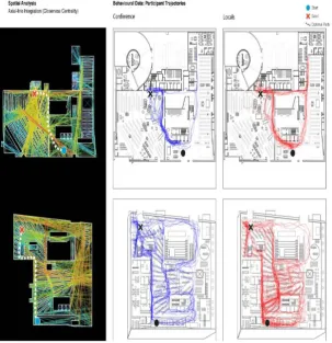
× accessibility manipulation, we examined the wayfinding tasks in more detail (Figures 5 and 6, and Table 6). Based on an custom coding-scheme, we captured sequences of events and
counted how many participants used a certain strategy. This was necessary because the
distance along two paths could statistically be the same, even though participants navigated
different paths. We identified the following explanations for wayfinding complexity:
Within-floor tasks. As expected, the CR (w/h) task was easy because most
participants correctly identified the children’s section, in direct sight, and navigated directly
towards the correct target direction. The only error was navigating in accordance with a
misbelieved target of the adult restrooms, from which one could easily retrace and correct the
error. In this sense, the high visual accessibility facilitated wayfinding.
However, in the SH (w/l) task, we noted that deviations/PAO were very high.
Participants mainly followed bookshelf information, which is normally a useful strategy for
compatible with the non-traditional design of this building, they started wandering through
integrated areas on the floor. In this sense, the SH task (w/l) was most closely aligned with
our building analyses; i.e., wayfinders preferring routes through central areas (cf., Kuipers,
Tecuci, & Stankiewicz, 2003). We reasoned that the segregation of the destination and the
specific spatial organization were probable reasons why the SH task proved more difficult
than we had expected and was even harder than the between-floor M6 task.
Between-floor tasks. In the M6 task (b/l), the view to the optimal shortest-route
travel option was blocked, and so the most common wayfinding error was taking the salient
yellow escalators and bypassing the correct floor. However, one reason why this task was
easier than we anticipated was that, on Floor 5, wayfinders had options to correct their error
by descending one floor in direct sight. Thus, even though the start and destination were in
segregated, remote locations, participants did not rank this task as difficult. We suggest that
one reason was the ease with which a person could correct a suboptimal decision.
The hardest task was that of Non-fiction DVDs (b/h). The suboptimal decision was
that participants navigated to Floor 3 with the semantically related Fiction DVDs. However,
their key challenge was that, on Floor 3, they did not receive feedback about whether the
error was immediate (correct floor, wrong section) or widespread (incorrect floor and
section). To compensate for this suboptimal decision to navigate to the Fiction DVDs on
Floor 3, participants had to ascend four floors on a path that required several disorienting
turns of direction. Reasoning post-hoc, the visual accessibility was high, but using semantic
information from one’s own expectations perhaps overshadowed the information present in
the environment. Thus, semantic organization of the architectural programming (dividing
Fiction from Non-fiction DVDs), and the complex recovery of this particular wayfinding
error were potential reasons why participants experienced challenges. They also appeared to
at a severe memory load imposed by the complex structure (cf., Hölscher et al., 2009).
In summary, considering the effects of building characteristics, as reflected in our
floor ×accessibility manipulation, along with individual differences and strategy outcomes, we made two tentative conclusions. First, each task had unique demands that taxed the skills
and strategies of our wayfinders in different ways. Participants were good or poor at specific
tasks rather than in their overall general performance; and this was associated with building
characteristics, mental transformation components of spatial skills, survey-related
preferences, and strategies compatible with a task’s demands. This is consistent with the
interactive approach postulated in Carlson et al.’s framework (2010). Second, non-spatial
reasons also explained why participants got lost: we reasoned that semantic interpretations
and related expectations about this library influenced making suboptimal decisions. In
addition, the way participants ranked a task’s difficulty reflected the fact that they assigned
worse rankings when it was harder for them to recover from suboptimal decisions and errors.
Discussion
The purpose of this study was to evaluate a known to be disorienting structure, the
Seattle Central Library, and to examine the relationships between certain building
characteristics and an individual’s orientation skills and strategies. Our wayfinding tasks were
devised to address high/low accessibility by between-/within-floor wayfinding. We then
analyzed wayfinding performance in relation to several individual difference measures.
When assessed across all tasks, our statistical and observational results were largely
unpredicted. Instead, the key finding here was that individual wayfinders were good or poor
depending on the specific task (but not in general), and that those outcomes depended upon
their spatial abilities and strategies – but the interplay of strategies and spatial skills was
complex and nuanced. It included non-spatial aspects, such as preconceptions and semantic
task demands, adaptive strategies and skills, and other interactions. These interactions add
refinements to the original Carlson et al. framework (2010).
By investigating the particular tasks in detail, and how their difficulties mapped onto
this specificbuilding, we could illustrate how the current findings might support the
theoretical components defined by Carlson et al. (2010). These components appeared to be
interdependent in terms of predicting wayfinding success. We had assumed that the
characteristics of a building specified within that earlier framework referred to its physical
attributes. Although these are important, we would argue on the basis of various data that
building characteristics should also include its semantic organization and spatial
configuration, the first of which is adequately measured via space syntax methodologies.
Theoretical contributions: defining the factors that contribute to wayfinding complexity
Our results suggest that definitions for the factors from the Carlson et al. (2010)
framework could benefit from the following, more explicit, wording. The ‘building’
component should include not only physical attributes (as reflected in measures of spatial
legibility and lines of sight) but also information about how a building is organized, both
spatially and semantically. The ‘cognitive map’ component should cover cognitive selection
processes that determine, e.g., which information to encode, as dictated by the constraints of
a task. Finally, researchers should recognize that an individual wayfinder employs ‘skills and
strategies’ differently for different contexts, rather than performing generally well or poor.
Future research should be conducted to improve our understanding of this interplay
among building characteristics, user characteristics, task requirements, and individual
expectations, as well as their triggers in multi-level buildings. For example, such studies
could include state and trait variables (e.g., leisure exploration versus a time limit) as
underlying motivational or intrinsic goals, dynamic experiences, and the interplay among
wayfinding complexity in complex environments may be emotional influences, cultural
differences, crowding and attention/depletion (etc.), which we did not examine here. To
engage those facets and interactions, researchers might conduct controlled testing in a virtual
simulation of the environment (i.e., reproducing each spatial complexity in isolation). This
could shed light on the relative impact of building, building user, and contextual factors.
Eye-tracking could enhance the understanding of visual attention and reliance upon signage.
Practical contributions
The SCL is hard to navigate for an uninitiated wayfinder because the building
challenges our understanding or schema of what a library is. The unique characteristics of
this building are likely to trigger a cognitive mismatch between intrinsic expectations of how
a typical library ‘should’ look and the actual mental representation acquired from spatial
learning (cf., Zook & Bafna, 2013). The library thereby plays with semantic expectations (see
work by Frankenstein, 2015, about spatial features that trigger semantic knowledge, as well
as notions that such conceptions and expectations should be central to an individual’s spatial
behavior in built environments, as addressed by Barker (1968) and Canter (1977)). This
disruption might explain why our participants experienced hardship during our most
challenging tasks.
Consequently, our practical implications for building planners are clear: building
users are incredibly diverse, and spatially and semantically complex structures can tax even
the most-skilled wayfinders. It is worth considering, with more nuance, the traits of
individual patrons; applying the ‘one size does not fit all’ approach that involves realizing the
levels of competence, spatial reasoning, and strategies that users bring, including the
perspective of a least-competent user.
The planners of the SCL anticipated types of building users to a certain degree, and
2005; Mattern, 2007; Yaneva, 2009). However, the desire to be unconventional, an interest in
achieving an aesthetic experience, and a desire to change the definitions of a contemporary
library, ultimately, likely were stronger than functional considerations. The SCL evokes
spatial exploration and stimulating experiences beyond efficient, effective point-to-point
navigation. As such, wayfinding can be distressing (Carlson et al., 2010; Murakami, 2006).
Therefore, we suggest that it may be worth developing an integration of building evaluation
methods that captures users’ perspectives while ensuring that basic functional qualities, such
as effective, efficient, and pleasant wayfinding, are not overshadowed by the wish to
introduce unconventional architecture.
Limitations
Although we relied on systematic questions regarding participants’ unfamiliarity
(excluding three volunteers), we cannot rule out the possibility that some participants had
preconceptions before entering the building. Even a rough knowledge of a general floor
layout could have contributed to wayfinding performance. However, the wayfinding
difficulties in both samples clearly discounted familiarity by members of either group.
Given that participants were randomly assigned to their start locations, it was difficult
to account for individual spatial learning or levels of frustration being dependent upon their
successes achieved on previously experienced paths. By necessity, these choices ensured
experimental control. In addition, we did not allow the participants to use the elevators, ask
others for directions, or walk in groups, all of which are typical behaviors in everyday
wayfinding. Although our volunteers did not appear anxious during our observation periods,
we cannot rule out the possibility that any nervousness that emerged after failing one task
may have affected their abilities during subsequent tasks. We initially included classical
cognitive measures, such ‘pointing tasks’ to previously visited locations to assess the
measures and first-time visitors, this was an exploratory, secondary measure for us. First-time
visitors rely on their cognitive skills, information in their immediate environment, and
expectations. We could not analyze the pointing data due to technical problems, but since we
did not aim at formally testing Carlson et al.’s (2010) model, this does not affect our results.
We did not control the number of other visitors and associated operational noise but
collected data during regular opening hours. However, this constraint added realism to the
wayfinding tasks. We did not account for which exact information on signage the participants
might have read because the library staff did not allow us to use eye-tracking or audio
recordings during the study. Therefore, our assumptions about semantic expectations and
strategies arose from post-hoc reasoning. Finally, we intentionally studied wayfinding in an
architecturally unique building that combined several complexities, a situation not likely to
occur in other buildings.
Conclusions
To summarize, our intent was to explore multi-level wayfinding in a real-world
setting featuring a strong variety of visual and spatial features. Our results challenge the
premise that any given individual can be readily and absolutely classified as a good or poor
wayfinder. Instead, a wayfinder’s performance may be good or less efficient as a function of
the interplay among building, cognitive map, individual, and task. Relatedly, the observation
that different persons can excel at different types of tasks has important implications for
user-centered design. That is, ‘one size will not fit all’ suggests that designers must consider an
environment that will allow success in light of multiple different strategies, solutions, or
skills, and that those plans account for the incredible diversity among building users. Taken
together, our research elevates the need to understand the challenges of wayfinding in light of
a more comprehensive and interactive approach.
Allen, G. L., Kirasic, K. C., Dobson, S. H., Long, R. G., & Beck, S. (1996). Predicting
environmental learning from spatial abilities: An indirect route. Intelligence, 22 (3),
327-355. doi: 10.1016/S0160-2896(96)90026-4
Allen, G. L. (1999). Spatial abilities, cognitive maps, and wayfinding. In R. G. Golledge
(Ed.), Wayfinding behavior: Cognitive mapping and other spatial processes (pp. 46–
80). Baltimore: Johns Hopkins University Press.
American Library Association (2005). AIA/ALA Library Buildings Award [award].
Retrieved from http://www.ala.org/llama/awards/aiaalalibrarybuildings
Arthur, P., & Passini, R. (1992). Wayfinding: People, signs, and architecture. New York:
McGraw-Hill Book.
Bafna, S. (2003). Space Syntax: A brief introduction to its logic and analytical techniques.
Environment and Behavior, 35 (1), 17-29. doi: 10.1177/0013916502238863
Barker, R. G. (1968). Ecological Psychology: Concepts and methods for studying the
environment of human behavior. Stanford: Stanford University Press.
Baskaya, A., Wilson, C., & Özcan, Y. Z. (2004). Wayfinding in an unfamiliar environment
different spatial settings of two polyclinics. Environment and Behavior, 36 (6), 839-
867. doi: 1177/0013916504265445
Batty, M. (2004). A new theory of Space Syntax [working paper]. Retrieved from
http://discovery.ucl.ac.uk/211/1/paper75.pdf
Batty, M. (2004b). Distance in Space Syntax [working paper]. Retrieved from
http://discovery.ucl.ac.uk/206/1/paper80.pdf
Batty, M. (2017). Space Syntax and spatial interaction: Comparisons, integrations,
applications [working paper]. Retrieved from
Benedikt, M. L., & Burnham, C. A. (1985). Perceiving architectural space: From optic arrays
to Isovists. In W. H. Warren (Jr.) & R. E. Shaw (Eds.), Persistence and change:
Proceedings of the first international conference on event perception (pp. 103-114).
Hillsdale: Lawrence Erlbaum.
Benedikt, M. L. (1979). To take hold of space: Isovists and Isovist fields. Environment and
Planning B: Planning and Design, 6 (1), 47-65. doi: 10.1068/b060047
Büchner, S. (2010). Environmental structure, mental representations and path choice
heuristics – information processing in wayfinding [unpublished doctoral
dissertation]. Freiburg: University of Freiburg.
Burgess, N. E., Jeffery, K. J., & O’Keefe, J.E. (1999). The hippocampal and parietal
foundations of spatial cognition. Oxford: Oxford University Press.
Canter, D. (1977). The psychology of place. New York: St. Martin Press.
Carlson, L. A., Hölscher, C., Shipley, T. F., & Dalton, R. C. (2010). Getting lost in buildings.
Current Directions in Psychological Science, 19 (5), 284-289.
doi: 10.1177/0963721410383243
Chang, D. (1998). Integrated multi-floor circulation systems in dense urban areas: The
effects of complex spatial designs on multi floor pedestrian movement [unpublished
doctoral dissertation], London: University of London.
Craigslist (n.d.). [website]. Retrieved from https://seattle.craigslist.org/
Dalton, N., Dalton, R., & Hölscher, C. (2015). People Watcher: An app to record and
analyzing spatial behavior of ubiquitous interaction technologies. In A. Gehring,
A. Krüger, F. Alt, & N. Taylor (Eds.), Proceedings of the fourth international
symposium on pervasive displays (pp.1-6). New York: ACM.
Dalton, R. C., Kuliga, S., & Hölscher, C. (2013). POE 2.0: Exploring the potential of social
media for capturing unsolicited post occupancy evaluations. Intelligent
Buildings International, 5(3), 62–180. doi: 10.1080/17508975.2013.800813
Dara-Abrams, D. (2006). Ground truthing Space Syntax. In K. F. Richter, & U. J. Rüetschi
(Eds.), The cognitive approach to modeling environments (pp. 23-28).
Freiburg/Bremen: Report series of the transregional collaborative research center
SFB/TR 8 ‘Spatial Cognition’ (Report No. 009-08/2006).
Dogu, U., & Erkip, F. (2000). Spatial factors affecting wayfinding and orientation: A case
study in a shopping mall. Environment and Behavior, 32 (6), 731-755.
doi: 10.1177/00139160021972775
Dovey, K. (2017). One way street. In R. C. Dalton, & C. Hölscher (Eds.), Take one
building: Interdisciplinary research perspectives of the Seattle Central Library (pp.
53-66). New York: Routledge.
Downs, R. M., & Stea, D. (2011). Chapter 4.3 Cognitive maps and spatial behavior: Process
and products. In M. Dodge, R. Kitchin & C. Perkins, The map reader: Theories of
mapping practice and cartographic representation (pp. 312-317). New Jersey: John
Wiley & Sons / Blackwell. doi: 10.1002/9780470979587.ch41
Eaton, G. (1991). Wayfinding in the library: Book searches and route uncertainty. Reference
Quarterly,30 (4), 519-527. doi: 10.2307/25828878
Evans, G. W. (1980). Environmental cognition. Psychological Bulletin, 88 (2), 259–287.
doi: 10.1006/jevp.1998.0089
Ferré, A., Hwang, I., Kubo, M., Prat, R., Sakamoto, T., Salazar, J., …, & Tetas, A. (2004).
Verb Architecture Boogazine: Connection. The changing status of the city, of
people, and uses. Barcelona: Actar.
Fields, A. W., & Shelton, A. L. (2006). Individual skill differences and large-scale
environmental learning. Journal of Experimental Psychology: Learning, Memory, and
Cognition, 32 (3), 506-515. doi: 10.1037/0278-7393.32.3.506
Fisher, K. E., Saxton, M. L., Edwards, P. M., & Mai, J.-E. (2007). Seattle Public Library as a
place: reconceptualizing space, community, and information at the Central Library. In
J. E. Buschman, & G. J. Leckie (Eds.). The library as place: History, community, and
culture (pp. 135-160). Westport: Libraries Unlimited.
Frankenstein, J. (2015). Human spatial representations and spatial memory retrieval
[doctoral dissertation]. Diss. ETH No. 22980, Zurich: ETH
Zürich. doi: 10.3929/ethz-a-010608257
Gärling, T., Lindberg, E., & Mäntylä, T. (1983). Orientation in buildings: Effects of
familiarity, visual access, and orientation aids. Journal of Applied Psychology, 68 (1),
177-186. doi: 10.1037/0021-9010.68.1.177
Golledge, R. G. (1999). Human wayfinding and cognitive maps. In R.G. Golledge (Ed.),
Wayfinding behavior: Cognitive mapping and other spatial processes, (pp. 5-45).
Baltimore: Johns Hopkins University Press.
Grice, H. P. (1975). Logic and conversation. In P. Cole & J. Morgan (Eds.). Syntax and
semantics 3: Speech acts (pp. 41–58). New York: Academic Press.
Haq, S., & Zimring, C. (2003). Just down the road a piece: The development of topological
knowledge of building layouts. Environment and Behavior, 35 (1), 132-160.
doi: 10.1177/0013916502238868
Hartley, T., Maguire, E. A., Spiers, H. J., & Burgess, N. (2003). The well-worn route and the
path less traveled: Distinct neural bases of route following and wayfinding in humans.
Hegarty, M., Montello, D. R., Richardson, A. E., Ishikawa, T., & Lovelace, K. (2006).
Spatial abilities at different scales: Individual differences in aptitude-test performance
and spatial layout learning. Intelligence, 34 (2), 151-176. doi:
10.1016/j.intell.2005.09.005
Hegarty, M., Richardson, A. E., Montello, D. R., Lovelace, K., & Subbiah, I. (2002).
Development of a self-report measure of environmental spatial ability. Intelligence,
30 (5), 425-447. doi: 10.1016/S0160-2896(02)00116-2
Hegarty, M., & Waller, D. (2004). A dissociation between mental rotation and perspective-
taking spatial abilities. Intelligence, 32 (2), 175-191. doi: 10.1016/j.intell.2003.12.001
Hillier, B., Burdett, R., Peponis, J., & Penn, A. (1987). Creating life: Or, does architecture
determine anything? Architecture and Behaviour, 3 (3), 233-250.
Hillier, B., & Hanson, J. (1984). The social logic of space. Cambridge: Cambridge University
Press. doi.org/10.1017/CBO9780511597237
Hochmair, H., & Karlsson, V. (2005). Investigation of preference between the least-angle
strategy and the initial segment strategy for route selection in unknown environments.
In C. Freksa, M. Knauff, B. Krieg-Brueckner, B. Nebel, & T. Barkowsky (Eds.),
Spatial cognition IV: Reasoning, action, interaction (pp. 79– 97). Berlin: Springer.
Hölscher, C., Meilinger, T., Vrachliotis, G., Brösamle, M., & Knauff, M. (2006). Up the
down staircase: Wayfinding strategies in multi-floor buildings. Journal of
Environmental Psychology, 26 (4), 284-299. doi: 10.1016/j.jenvp.2006.09.002
Hölscher, C., Büchner, S. J., Meilinger, T., & Strube, G. (2009). Adaptivity of wayfinding
strategies in a multi-building ensemble: The effects of spatial structure, task
requirements, and metric information. Journal of Environmental Psychology, 29 (2),
208-219. doi: 10.1016/j.jenvp.2008.05.010